Thayer Township | |
|---|---|
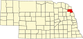
 Location in Thurston County | |
| Coordinates: 42°07′59″N096°46′56″W / 42.13306°N 96.78222°W | |
| Country | United States |
| State | Nebraska |
| County | Thurston |
| Area | |
• Total | 23.95 sq mi (62.03 km2) |
| • Land | 23.95 sq mi (62.03 km2) |
| • Water | 0 sq mi (0 km2) 0% |
| Elevation | 1,381 ft (421 m) |
| Population | |
• Total | 111 |
| • Density | 4.63/sq mi (1.79/km2) |
| ZIP code | 68047 [2] |
| Area codes | 402 and 531 |
| GNIS feature ID | 0838281 |
Thayer Township is one of eleven townships in Thurston County, Nebraska, United States. The population was 111 at the 2020 census. [1]