Oakland, Nebraska

Last updated

Oakland, Nebraska
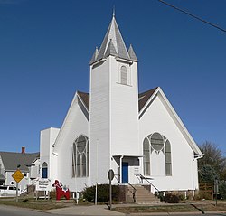
Oakland, Nebraska Swedish Heritage Center.JPG
Swedish Heritage Center, occupying former Swedish Covenant Church in Oakland [1]
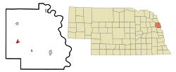
Burt County Nebraska Incorporated and Unincorporated areas Oakland Highlighted.svg
Location of Oakland, Nebraska
Coordinates: 41°50′08″N96°28′01″W / 41.83556°N 96.46694°W / 41.83556; -96.46694
Country United States
State Nebraska
County Burt
Area
[2]
  Total0.95 sq mi (2.46 km2)
  Land0.95 sq mi (2.46 km2)
  Water0.00 sq mi (0.00 km2)
Elevation
[3]
1,293 ft (394 m)
Population
 (2020)
  Total1,369
  Density1,442.57/sq mi (557.21/km2)
Time zone UTC-6 (Central (CST))
  Summer (DST) UTC-5 (CDT)
ZIP code
68045
Area code 402
FIPS code 31-35490
GNIS feature ID838169 [3]
Website www.ci.oakland.ne.us

Oakland is a city in Burt County, Nebraska, United States. The population was 1,244 at the 2010 census. Oakland continues to build on its strong foundation with its bi-annual Swedish Festival and is known by its proclamation from the Swedish Consul-General and the Governor of Nebraska as the "Swedish Capital of Nebraska."

Contents

Geography

According to the United States Census Bureau, the city has a total area of 0.93 square miles (2.41 km2), all land. [4]

History

Downtown Oakland Oakland, Nebraska Oakland from 2nd 2.JPG
Downtown Oakland

Oakland was named after John Oak, an early settler. [5] The village was incorporated April 13, 1881, with 30 businesses, two banks and one printing office in operation. Basic economic activities in the Oakland area soon included farming, cattle and hog production, feed processing, wholesale and retail sales. In 1900, the Chicago, Burlington and Quincy Railroad were built to Oakland. [6]

Oakland was home to the Swedish Basketball Classic from 1993 to 2006, which has since moved to Midland University in Fremont and changed its name to the Warrior Classic. Oakland has also been home to the Burt County Fair since 1913.

A residential street in Oakland, Nebraska c. 1920 A E Hanna.jpg
A residential street in Oakland, Nebraska c. 1920

Demographics

Historical population
CensusPop.Note
1880 345
1890 807133.9%
1900 1,00824.9%
1910 1,0736.4%
1920 1,35626.4%
1930 1,4335.7%
1940 1,380−3.7%
1950 1,4565.5%
1960 1,429−1.9%
1970 1,355−5.2%
1980 1,3932.8%
1990 1,279−8.2%
2000 1,3676.9%
2010 1,244−9.0%
2020 1,36910.0%
U.S. Decennial Census [7]

2010 census

As of the census [8] of 2010, there were 1,244 people, 528 households, and 343 families living in the city. The population density was 1,337.6 inhabitants per square mile (516.5/km2). There were 633 housing units at an average density of 680.6 per square mile (262.8/km2). The racial makeup of the city was 96.0% White, 0.5% African American, 1.3% Native American, 0.9% Asian, and 1.4% from two or more races. Hispanic or Latino of any race were 0.6% of the population.

There were 528 households, of which 28.2% had children under the age of 18 living with them, 54.2% were married couples living together, 7.6% had a female householder with no husband present, 3.2% had a male householder with no wife present, and 35.0% were non-families. 33.0% of all households were made up of individuals, and 20% had someone living alone who was 65 years of age or older. The average household size was 2.28 and the average family size was 2.85.

The median age in the city was 44.9 years. 25.2% of residents were under the age of 18; 3.2% were between the ages of 18 and 24; 21.6% were from 25 to 44; 25.7% were from 45 to 64; and 24.2% were 65 years of age or older. The gender makeup of the city was 48.9% male and 51.1% female.

2000 census

As of the census of 2000, there were 1,367 people, 565 households, and 371 families living in the city. The population density was 1,695.3 inhabitants per square mile (654.6/km2). There were 623 housing units at an average density of 772.6 per square mile (298.3/km2). The racial makeup of the city was 98.68% White, 0.22% Native American, 0.15% Asian, and 0.95% from two or more races. Hispanic or Latino of any race were 0.73% of the population.

There were 565 households, out of which 25.8% had children under the age of 18 living with them, 58.4% were married couples living together, 5.7% had a female householder with no husband present, and 34.2% were non-families. 32.7% of all households were made up of individuals, and 23.2% had someone living alone who was 65 years of age or older. The average household size was 2.32 and the average family size was 2.94.

In the city, the population was spread out, with 24.2% under the age of 18, 5.0% from 18 to 24, 21.4% from 25 to 44, 20.9% from 45 to 64, and 28.5% who were 65 years of age or older. The median age was 45 years. For every 100 females, there were 84.5 males. For every 100 females age 18 and over, there were 80.5 males.

As of 2000 the median income for a household in the city was $32,663, and the median income for a family was $42,938. Males had a median income of $31,600 versus $19,583 for females. The per capita income for the city was $16,916. About 3.8% of families and 6.2% of the population were below the poverty line, including 3.2% of those under age 18 and 9.1% of those age 65 or over.
Notable people

Oakland is the birthplace of Jon Kyl, U.S. Senator from Arizona, and Curt Bromm, the former Speaker of the Nebraska Legislature.

Related Research Articles

<span class="mw-page-title-main">Burt County, Nebraska</span> County in Nebraska, United States

Burt County is a county in the U.S. state of Nebraska, bordering the west bank of the upper Missouri River. As of the 2020 United States Census, the population was 6,722. Its county seat is Tekamah. The county was formed in 1854 and named after Francis Burt, the first governor of Nebraska Territory.

Deerwood Township is a township in Crow Wing County, Minnesota, United States. The population was 1,244 at the 2000 census.

<span class="mw-page-title-main">Mountain Iron, Minnesota</span> City in Minnesota, United States

Mountain Iron is a city in Saint Louis County, Minnesota, United States, in the heart of the Mesabi Range. The population was 2,878 at the 2020 census.

<span class="mw-page-title-main">Lake Waukomis, Missouri</span> City in Missouri, United States

Lake Waukomis is a city in Platte County, Missouri and is part of the Kansas City metropolitan area within the United States. The population was 888 at the 2020 census.

<span class="mw-page-title-main">Oakland, Missouri</span> City in Missouri, United States

Oakland is a city in St. Louis County, Missouri, United States. The population was 1,381 at the 2010 census.

<span class="mw-page-title-main">Saronville, Nebraska</span> Village in Nebraska, United States

Saronville is a village in Clay County, Nebraska, United States. The population was 35 at the 2020 census. It is part of the Hastings, Nebraska Micropolitan Statistical Area.

<span class="mw-page-title-main">Bennington, Nebraska</span> City in Douglas County, Nebraska, United States

Bennington is a city in Douglas County, Nebraska, United States. The population was 2,026 at the 2020 U.S. Census.

<span class="mw-page-title-main">Burwell, Nebraska</span> City in Nebraska, United States

Burwell is a city in Garfield County, Nebraska, United States. The population was 1,210 at the 2010 census. It is the county seat of Garfield County.

<span class="mw-page-title-main">Atkinson, Nebraska</span> City in Nebraska, United States

Atkinson is a city in Holt County, Nebraska, United States. The population was 1,245 at the 2010 census.

<span class="mw-page-title-main">Bloomfield, Nebraska</span> City in Nebraska, United States

Bloomfield is a city in Knox County, Nebraska, United States. The population was 1,028 at the 2010 census.

<span class="mw-page-title-main">Stromsburg, Nebraska</span> City in Polk County, Nebraska, United States

Stromsburg is a city in Polk County, Nebraska, United States. The population was 1,028 as per the 2020 census.

<span class="mw-page-title-main">Bassett, Nebraska</span> City in and county seat of Rock County, Nebraska, United States

Bassett is a city in Rock County, Nebraska, United States. The population was 538 at the 2020 census. It is the county seat of Rock County.

<span class="mw-page-title-main">Bellevue, Nebraska</span> City in Sarpy County, Nebraska, United States

Bellevue is a suburban city in Sarpy County, Nebraska, United States. It is part of the Omaha–Council Bluffs metropolitan area, and had a population of 64,176 as of the 2020 census, making it the 3rd most populous city in Nebraska, behind Omaha and Lincoln, and the second largest city in the U.S. named "Bellevue," behind Bellevue, Washington.

<span class="mw-page-title-main">La Vista, Nebraska</span> City in Sarpy County, Nebraska, United States

La Vista is a city in Sarpy County, Nebraska, United States. The population was 16,746 at the 2020 census, making it the 12th most populous city in Nebraska. The city was incorporated on February 23, 1960.

<span class="mw-page-title-main">Ashland, Nebraska</span> City in Saunders County, Nebraska, United States

Ashland is a city in Saunders County, Nebraska, United States. The population was 3,086 at the 2020 census.

<span class="mw-page-title-main">Malmo, Nebraska</span> Village in Saunders County, Nebraska, United States

Malmo is a village in Saunders County, Nebraska, United States. The population was 94 at the 2020 census.

<span class="mw-page-title-main">Melbeta, Nebraska</span> Village in Scotts Bluff County, Nebraska, United States

Melbeta is a village in Scotts Bluff County, Nebraska, United States. It is part of the Scottsbluff, Nebraska Micropolitan Statistical Area. The population was 112 at the 2010 census.

<span class="mw-page-title-main">Seward, Nebraska</span> City in and county seat of Seward County, Nebraska, United States

Seward is a city and county seat of Seward County, Nebraska, United States. The population was 6,964 at the 2010 census. Seward is part of the Lincoln, Nebraska Metropolitan Statistical Area.

<span class="mw-page-title-main">Fort Calhoun, Nebraska</span> City in Washington County, Nebraska, United States

Fort Calhoun is a city in Washington County, Nebraska, United States. The population was 1,108 at the 2020 census. The city includes Fort Atkinson, the first fort built west of the Missouri River.

<span class="mw-page-title-main">Oakland Township, Susquehanna County, Pennsylvania</span> Township in Pennsylvania, United States

Oakland Township is a township in Susquehanna County, Pennsylvania, United States. The population was 492 at the 2020 census.

References

  1. "Day 377--Oakland". NordicWay.com. Retrieved 2010-11-05.
  2. "ArcGIS REST Services Directory". United States Census Bureau. Retrieved September 18, 2022.
  3. 1 2 U.S. Geological Survey Geographic Names Information System: Oakland, Nebraska
  4. "US Gazetteer files 2010". United States Census Bureau. Archived from the original on January 12, 2012. Retrieved June 24, 2012.
  5. Chicago and North Western Railway Company (1908). A History of the Origin of the Place Names Connected with the Chicago & North Western and Chicago, St. Paul, Minneapolis & Omaha Railways. p. 185.
  6. Valkommen (Welcome) to Oakland,Swedish Capital of Nebraska! (Welcome to Oakland)
  7. United States Census Bureau. "Census of Population and Housing" . Retrieved November 13, 2013.
  8. "U.S. Census website". United States Census Bureau . Retrieved June 24, 2012.