Lyons, Nebraska

Last updated

Lyons, Nebraska
Residential neighborhood, Lyons, Nebraska.jpg
Houses and streets in Lyons
Burt County Nebraska Incorporated and Unincorporated areas Lyons Highlighted.svg
Location of Lyons, Nebraska
Coordinates: 41°56′10″N96°28′20″W / 41.93611°N 96.47222°W / 41.93611; -96.47222
Country United States
State Nebraska
County Burt
Area
[1]
  Total0.69 sq mi (1.79 km2)
  Land0.68 sq mi (1.77 km2)
  Water0.01 sq mi (0.02 km2)
Elevation
[2]
1,293 ft (394 m)
Population
 (2020)
  Total824
  Density1,206.44/sq mi (466.01/km2)
Time zone UTC-6 (Central (CST))
  Summer (DST) UTC-5 (CDT)
ZIP code
68038
Area code 402
FIPS code 31-29855
GNIS feature ID2395794 [2]
Website lyonscity.nebraska.gov

Lyons is a city in Burt County, Nebraska, United States. The population was 851 in the 2010 census. The city is named after its founder.

Contents

History

The first settlers of Lyons came in the summer of 1866. The fertile soil of the Logan Valley, combined with the commercial promise provided by access to the railroad after 1881, assured the life of the town. Incorporated in 1884, the village was named for Waldo Lyon, a prominent citizen upon whose land the plots were laid out. [3] Residents have continued to abide by a provision in Lyons' deed stipulating that liquor not be sold within the town at risk of forfeit of the property. [4]

The Lyons Roller Mill was erected in 1869. The three-story structure was powered by water from a dam built across Logan Creek just west of the town, and was in operation until 1931.

Many of the buildings of the town are constructed of brick manufactured in a brickyard which began operation in 1878. The swimming pool sits in the depression from which the clay was taken.

One of the finest trotting tracks in the country opened in 1891. Just one-fourth mile west of Lyons named the Kite Track. Famous horses broke world records and won large purses on this kite-shaped race track before hard times ended racing after 1893. [5]

Geography

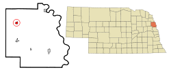
According to the United States Census Bureau, the city has a total area of 0.69 square miles (1.79 km2), of which 0.68 square miles (1.76 km2) is land and 0.01 square miles (0.03 km2) is water. [6]

Lyons is on U.S. Route 77, south of the Omaha Indian Reservation and west of the Missouri River.

Demographics

Historical population
CensusPop.Note
1880 90
1890 532491.1%
1900 84759.2%
1910 8652.1%
1920 1,02518.5%
1930 985−3.9%
1940 1,0334.9%
1950 1,011−2.1%
1960 974−3.7%
1970 1,17720.8%
1980 1,2143.1%
1990 1,144−5.8%
2000 963−15.8%
2010 851−11.6%
2020 824−3.2%
U.S. Decennial Census [7]

2010 census

As of the census [8] of 2010, there were 851 people, 395 households, and 228 families residing in the city. The population density was 1,251.5 inhabitants per square mile (483.2/km2). There were 457 housing units at an average density of 672.1 per square mile (259.5/km2). The racial makeup of the city was 96.7% White, 0.1% African American, 0.9% Native American, 0.2% Pacific Islander, 1.3% from other races, and 0.7% from two or more races. Hispanic or Latino of any race were 3.2% of the population.

There were 395 households, of which 19.2% had children under the age of 18 living with them, 48.6% were married couples living together, 6.8% had a female householder with no husband present, 2.3% had a male householder with no wife present, and 42.3% were non-families. 37.5% of all households were made up of individuals, and 23.1% had someone living alone who was 65 years of age or older. The average household size was 2.05 and the average family size was 2.66.

The median age in the city was 51.7 years. 16.1% of residents were under the age of 18; 7.5% were between the ages of 18 and 24; 16.8% were from 25 to 44; 29.5% were from 45 to 64; and 30.1% were 65 years of age or older. The gender makeup of the city was 45.8% male and 54.2% female.

2000 census

As of the census of 2000, there were 963 people, 423 households, and 280 families residing in the city. The population density was 1,377.2 inhabitants per square mile (531.7/km2). There were 474 housing units at an average density of 677.9 per square mile (261.7/km2). The racial makeup of the city was 98.13% White, 0.31% African American, 0.21% Native American, 0.10% Asian, 0.10% Pacific Islander, 0.93% from other races, and 0.21% from two or more races. Hispanic or Latino of any race were 5.19% of the population.

There were 423 households, out of which 25.3% had children under the age of 18 living with them, 52.0% were married couples living together, 10.6% had a female householder with no husband present, and 33.8% were non-families. 31.0% of all households were made up of individuals, and 21.3% had someone living alone who was 65 years of age or older. The average household size was 2.25 and the average family size was 2.80.

Former water tower in Lyons Old water tower, Lyons, Nebraska.jpg
Former water tower in Lyons
Railroad tracks in Lyons Railroad tracks, Lyons, Nebraska.jpg
Railroad tracks in Lyons

In the city, the population was spread out, with 24.1% under the age of 18, 5.0% from 18 to 24, 21.1% from 25 to 44, 22.4% from 45 to 64, and 27.4% who were 65 years of age or older. The median age was 45 years. For every 100 females, there were 83.8 males. For every 100 females age 18 and over, there were 78.3 males.

The median income for a household in the city was $28,804, and the median income for a family was $35,625. Males had a median income of $27,563 versus $20,250 for females. The per capita income for the city was $16,368. About 6.7% of families and 9.2% of the population were below the poverty line, including 10.3% of those under age 18 and 8.2% of those age 65 or over.

Points of Interest

Center for Rural Affairs

Lyons is home to the Center for Rural Affairs, a private non-profit organization. [9] The organization's mission statement is: "Establish strong rural communities, social and economic justice, environmental stewardship, and genuine opportunity for all while engaging people in decisions that affect the quality of their lives and the future of their communities." [10] It was established in Walthill, Nebraska in 1973, [9] and moved to Lyons in 2004. [11]

Storefront Theater

The Storefront Theater is located on Main Street in Lyons. It is one of four projects that are a part of the Byway of Art project created through a $200,000 ArtPlace America grant awarded to the Center for Rural Affairs. [12] The Byway of Art project was created by former Lyons resident Adele Phillips and conceptual artist Matthew Mazzotta. [13] The Storefront Theater creates a seating and performance area on the street. When not in use the structure appears to be a typical storefront. However, what appears to be a standard building consists of a false facade that lowers down toward the street and over the sidewalk. Bleachers behind the storefront theater pull out for seating. [12] [13] The Storefront Theater was selected as part of the Americans for the Arts 2016 Public Art Network Year in Review program. [14]

See also

Related Research Articles

<span class="mw-page-title-main">Otoe County, Nebraska</span> County in Nebraska, United States

Otoe County is a county in the U.S. state of Nebraska. As of the 2020 United States Census, the population was 15,912. Its county seat is Nebraska City. The county was formed in 1854, and was named tor the Otoe Indian tribe.

<span class="mw-page-title-main">Fairview, Kansas</span> City in Brown County, Kansas

Fairview is a city in Brown County, Kansas, United States. As of the 2020 census, the population of the city was 240.

<span class="mw-page-title-main">Hillsboro, Missouri</span> City in Missouri, United States

Hillsboro is a city in Jefferson County, Missouri, United States. The population was 3,473 at the 2020 census, up from 2,821 in 2010. Hillsboro is the county seat of Jefferson County.

<span class="mw-page-title-main">Tekamah, Nebraska</span> City in Nebraska, United States

Tekamah is a city in Burt County, Nebraska, United States. The population was 1,736 at the 2010 census. It is the county seat of Burt County.

<span class="mw-page-title-main">Avoca, Nebraska</span> Village in Nebraska, United States

Avoca is a village in Cass County, Nebraska, United States. The population was 178 at the 2020 census.

<span class="mw-page-title-main">Belden, Nebraska</span> Village in Nebraska, United States

Belden is a village in Cedar County, Nebraska, United States. The population was 112 at the 2020 census.

<span class="mw-page-title-main">Maskell, Nebraska</span> Village in Dixon County, Nebraska, United States

Maskell is a village in Dixon County, Nebraska, United States. It is part of the Sioux City, IA–NE–SD Metropolitan Statistical Area. The population was 76 at the 2010 census. It is reportedly home to the smallest city hall in the United States.

<span class="mw-page-title-main">Waterbury, Nebraska</span> Village in Dixon County, Nebraska, United States

Waterbury is a village in Dixon County, Nebraska, United States. It is part of the Sioux City, IA–NE–SD Metropolitan Statistical Area. The population was 73 at the 2010 census.

<span class="mw-page-title-main">Bennington, Nebraska</span> City in Douglas County, Nebraska, United States

Bennington is a city in Douglas County, Nebraska, United States. The population was 2,026 at the 2020 U.S. Census.

<span class="mw-page-title-main">Boys Town, Nebraska</span> Village in Douglas County, Nebraska, United States

Boys Town is a village in Douglas County, Nebraska, United States. The population was 410 at the 2020 census. Boys Town is an enclave and a suburb of Omaha.

<span class="mw-page-title-main">Waterloo, Nebraska</span> Village in Douglas County, Nebraska, United States

Waterloo is a village in Douglas County, Nebraska, United States. The population was 935 at the 2020 census.

<span class="mw-page-title-main">Beaver City, Nebraska</span> City in Nebraska, United States

Beaver City is a city in Furnas County, on the southern border of Nebraska, United States. The population was 609 at the 2010 census. It is the county seat of Furnas County.

<span class="mw-page-title-main">Wood River, Nebraska</span> Village in Hall County, Nebraska, United States

Wood River is a city in southwestern Hall County, Nebraska, United States. The population was 1,172 at the 2020 census. It is part of the Grand Island, Nebraska Metropolitan Statistical Area.

<span class="mw-page-title-main">Aurora, Nebraska</span> City in Nebraska, United States

Aurora is a city in Hamilton County, Nebraska, United States. The population was 4,479 at the 2010 census. It is the county seat of Hamilton County.

<span class="mw-page-title-main">Center, Nebraska</span> Village in and county seat of Knox County, Nebraska, United States

Center is a village in, and county seat of, Knox County, Nebraska, United States. The population was 73 at the 2020 census.

<span class="mw-page-title-main">Crofton, Nebraska</span> City in Nebraska, United States

Crofton is a city in Knox County, Nebraska, United States. The population was 726 at the 2010 census.

<span class="mw-page-title-main">Bayard, Nebraska</span> City in Nebraska, United States

Bayard is a city in Morrill County, Nebraska, United States. The population was 1,209 at the 2010 census.

<span class="mw-page-title-main">Pierce, Nebraska</span> City in Nebraska, United States

Pierce is a city in and county seat of Pierce County, Nebraska, United States. The population was 1,767 at the 2010 census.

<span class="mw-page-title-main">Ashland, Nebraska</span> City in Saunders County, Nebraska, United States

Ashland is a city in Saunders County, Nebraska, United States. The population was 3,086 at the 2020 census.

<span class="mw-page-title-main">Ord, Nebraska</span> City in Nebraska, United States

Ord is a city in Valley County, Nebraska, United States. The population was 2,112 at the 2010 census. It is the county seat of Valley County.

References

  1. "ArcGIS REST Services Directory". United States Census Bureau. Retrieved September 18, 2022.
  2. 1 2 U.S. Geological Survey Geographic Names Information System: Lyons, Nebraska
  3. Chicago and North Western Railway Company (1908). A History of the Origin of the Place Names Connected with the Chicago & North Western and Chicago, St. Paul, Minneapolis & Omaha Railways. p. 182.
  4. "Lyons, Burt County". Center for Advanced Land Management Information Technologies. University of Nebraska. Retrieved July 31, 2014.
  5. "History Nebraska". Historical Land Mark Council. Lyons Lions Club, 1967. Retrieved August 13, 2021.
  6. "US Gazetteer files 2010". United States Census Bureau. Archived from the original on January 25, 2012. Retrieved June 24, 2012.
  7. United States Census Bureau. "Census of Population and Housing" . Retrieved November 13, 2013.
  8. "U.S. Census website". United States Census Bureau . Retrieved June 24, 2012.
  9. 1 2 "Frequently Asked Questions". Center for Rural Affairs. Retrieved 2010-10-30.
  10. "Our Mission and Our Values". Center for Rural Affairs. Retrieved 2010-10-30.
  11. "History of the Center". Center for Rural Affairs. Retrieved 2010-10-30.
  12. 1 2 Journal, NICK HYTREK / Sioux City. "Lyons turns storefront into outdoor theater". JournalStar.com. Retrieved December 9, 2017.
  13. 1 2 Brocious, Ariana (November 17, 2015). "Public Art Projects Aim to Create Community on Main Street | netnebraska.org". netnebraska.org. Retrieved December 9, 2017.
  14. Smith, Elisha (June 17, 2016). "Lyons Storefront Theater Honored with National Award". Center for Rural Affairs. Retrieved December 9, 2017.
  15. Former Autovon Switching Centers.