Native American tribes in Nebraska

Last updated

An 1852 illustration of a Winnebago family encampment. Winnebago wigwam.jpg
An 1852 illustration of a Winnebago family encampment.

Native American tribes in the U.S. state of Nebraska have been Plains Indians, descendants of succeeding cultures of indigenous peoples who have occupied the area for thousands of years. More than 15 historic tribes have been identified as having lived in, hunted in, or otherwise occupied territory within the current state boundaries. [1]

Contents

The 19th-century history of the state included the establishment of eight Indian reservations, including a half-breed tract. Today six tribes, (Omaha, Winnebago, Ponca, Iowa, Santee Sioux, Sac and Fox), have reservations in Nebraska. In 2006 American Indian and Alaska Native persons comprised one percent of the state's population. [2] Towns at the northern border also have relations within reservations within South Dakota.

Tribes

Tribal territory of several tribes in Nebraska Pawnee01.png
Tribal territory of several tribes in Nebraska
This section from the Lewis and Clark map of 1804 shows period Indian villages in southwest Iowa, southeast Nebraska, and northwest Missouri. The Otoe, Iowa, Missouri and Kansas tribes are specifically identified. Nodaway-lewis.jpg
This section from the Lewis and Clark map of 1804 shows period Indian villages in southwest Iowa, southeast Nebraska, and northwest Missouri. The Otoe, Iowa, Missouri and Kansas tribes are specifically identified.

Several language groups were represented by the American Indians in present-day Nebraska. The Algonquian-speaking Arapaho lived for more than 1,000 years throughout the western part of Nebraska. [3] In a prehistoric period; Nebraska was home to the Arikara, who spoke a Caddoan language, as did the Pawnee; after 1823 they returned from present-day North Dakota to live with the Skidi Pawnee for two years. [4] The Kiowa once occupied western Nebraska. [5] The eastern range of the Algonquian-speaking Cheyenne included western Nebraska, after the Comanche who had formerly lived in the territory had moved south toward Texas. [6]

The Great Sioux Nation, including the Ihanktowan-Ihanktowana and the Lakota located to the north and west, used Nebraska as a hunting and skirmish ground, although they did not have any long-term settlements in the state. [7] [8]

The Omaha belong to the Siouan-language family of the Dhegihan branch, and have been located along the Missouri River in northeastern Nebraska since the late 17th century, after having migrated from eastern areas together with other tribes. Originally living along the Ohio and Wabash rivers to the east, the Omaha, along with the Dhegihan Ponca, moved into Nebraska in the 1670s. Other Siouan-Dheigihan tribes who moved west from the Ohio River about then were the Osage, Kansa and Quapaw, who settled to the southwestern part of the territory. At that point the Ponca split, and the Omaha settled on Bow Creek in present-day Cedar County. [9] Before 1700, the Iowa, a Siouan people whose language was Chiwere, moved from the Red Pipestone Quarry into Nebraska. [10]

The Omaha separated from the Ponca at the mouth of White River in present-day South Dakota. The latter moved west into the Black Hills, but later they rejoined the Omaha. The Ponca settled at the Nemaha River while the Omaha became established to the south at Bow Creek.

By the Treaty of 1854, the Omaha ceded most of their land to the United States. They moved to a reservation within two years and later shared their land with the Winnebago. Also known by their autonym of Ho-Chunk, the latter moved to the reservation in 1862 after an uprising by the Lakota. The US government later granted land within the Omaha reservation boundaries to the Ho-Chunk, whose descendants still live there. [11]

In 1877 the United States forced the Ponca tribe to move south to Indian Territory in Oklahoma, although they had wanted to stay on a reservation in Nebraska. The failure of the government to support the people adequately after the removal and poor conditions on the reservation led to many deaths. The US Army's detention of some Ponca leaders who returned to Nebraska was challenged in court and the case followed nationally by many Americans. It resulted in the landmark civil rights case of Standing Bear v. Crook (1872), which established that American Indians shared in certain rights under the constitution. Following the court case, the US assigned the tribe some land in Nebraska. Today the Ponca Tribe of Nebraska live in Knox County; another part of the people live on their federally recognized reservation in Oklahoma.

The Missouri lived south of the Platte River and, along with the Otoe, met with the Lewis and Clark Expedition at the Council Bluff. Like the Iowa, both tribes are part of the Chiwere branch of the Siouan-language family. [12] In 1804 the Otoe had a town on the south side of the Platte River not far from its mouth on the Missouri. On March 3, 1881 the tribe sold all of their land in Nebraska to the federal government and moved to Indian Territory (now Oklahoma).

In 1830 the Fox Meskwaki and the Sauk, distinct Algonquian-speaking tribes that were closely related, ceded a great deal of land in Nebraska to the United States. [13] Today the tribes are federally recognized together.

The Pawnee, which included four tribes, lived in villages along the Platte River. In the mid-nineteenth century, they ceded all of their lands in Nebraska to the United States except one reservation; in 1876 they surrendered this tract and moved to Indian Territory. The battle of Massacre Canyon on August 5, 1873, was the last major battle between the Pawnee and the Sioux. About 70 Pawnee were killed, mostly women and children. [14]

Loss of land

Between 1857 and 1862 tribes were forced to give up, or ceded, land for sale in Nebraska in five separate treaties with the U.S. government in the years immediately leading up to the passage of the Homestead Act. [15] In 1854 Logan Fontenelle was chief and also translated the negotiations that led the Omaha to the first of five cessions of their lands to the United States. During the same negotiations, the tribe agreed to move to their present reservation to the north in Thurston County. [16] The Otoe and Missouri tribes negotiated the last of four treaties that same year, and the Pawnee, Arapaho and Cheyenne all signed treaties within a few years. [17]

In the 1870s the Nebraska Legislature petitioned the U.S. Congress for the extinction of the original holders' land rights in the state by drafting the following statement:

Whereas, the Indians now on special reservations in Nebraska hold and occupy valuable and important tracts of land, which while occupied will not be developed and improved; and Whereas the demand for lands which will be improved and made useful, are such that these Indian lands should no longer be held, but should be allowed to pass into the hands of enterprising and industrious citizens; ... [W]e urge upon our delegation in Congress to secure the removal of all Indians now on special reservations in Nebraska to other ... localities, where their presence will not retard settlements by the whites. [18]

Tribes and treaties

There are 18 separate treaties between American Indian tribes and the U.S. government for land in Nebraska which were negotiated between 1825 and 1892. By the 1850s the Pawnee, Omaha, Oto-Missouri, Ponca, Lakota, and Cheyenne were the main Great Plains tribes living in the Nebraska Territory. [19]

U.S. government treaties with American Indian tribes for land in Nebraska. [17]
TribeYearNotes
Kansas1825Ceded much of severe southeast Nebraska.
Oto1830The severe southeastern corner of Nebraska.
Oto1833Southeast Nebraska, near the mouth of the Platte, included land where the Moses Merill Mission was located.
Pawnee1833South-central Nebraska.
Pawnee1848A small tract along the Platte River in central Nebraska.
Omaha1854Almost all of east-central and northeast Nebraska.
Oto and Missouri1854East-central Nebraska immediately south of the Platte River.
Pawnee1857All of north-central Nebraska between the Platte River and the South Dakota border.
Arapaho and Cheyenne1861All of southwestern and some of west-central Nebraska south of the North Platte River.
Omaha1865A small parcel of land compromising 1/4 of their reservation.
Lakota1875All of west-central Nebraska north of the North Platte River.
Pawnee1875A small tract north of the Platte River that included the land that became the Genoa Indian Industrial School.
Lakota, Northern Cheyenne and Arapaho1876All of severe northwestern Nebraska.
Omaha1882Two parcels of land in two treaties comprising 1/2 of their reservation lands, including land for the Winnebago reservation.
Lakota1892Ceded a parcel of land including Pine Ridge, Nebraska.

Federal recognition

Today the United States government recognizes several tribes in Nebraska. They include the Iowa Tribe of Kansas and Nebraska, the Omaha Tribe of Nebraska, the Ponca Tribe of Nebraska, the Sac & Fox Nation of Missouri in Kansas and Nebraska, the Santee Sioux Tribe of the Santee Reservation of Nebraska, and the Winnebago Tribe of Nebraska. [20]

Reservations

Indian reservations in Nebraska currently include land of the Ioway, Santee Sioux, Omaha, Sac and Fox, Winnebago, and Ponca. The Omaha were forced to cede their Boone County lands to the U.S. government in 1854. The Pawnee were forced to gave up their Boone County lands in 1857. Nance County was a Pawnee reservation until 1875, when harassment by the whites and Sioux helped convince by force the Pawnee to relocate to Oklahoma. [21] The Oto, Omaha, and Ioway were forced to cede much of their land to the U.S. government in 1854, resulting in moving onto reservations in eastern Nebraska. That year the Nebraska Territory was organized and opened to settlement. [22]

Indian reservations in Nebraska. [23]
Reservation nameTribeEstablishedSizeHistoryNotes
Niobrara Reservation Santee Sioux 186341,000 acres (17,000 ha)Established by Act of March 3, 1863 (12  Stat.   819); treaty of April 29, 1868 (15  Stat.   637); Executive orders, February 27, 1866, November 16, 1867, August 31, 1869, December 31, 1873, and February 9, 1885. 32,875.75 acres (133.0434 km2) were selected as homesteads, 38,908.01 acres (157.4551 km2) as allotments, find 1,130.70 acres (4.5758 km2) for Indian agency, school, and mission purposes; unratified agreement of October 17, 1882.The tribal offices are located in Niobrara, with reservation lands in Knox County. [24]
Omaha Reservation Omaha185412,421 acres (5,027 ha)Established by Treaty of March 16, 1854 (10  Stat.   1043); selection by Indians with the President's approval, May 11, 1855; treaty of March 6, 1865 (14  Stat.   667); act of June 10, 1872 (17  Stat.   391); act of June 22, 1874 (18  Stat.   170); deed to the Winnebago, dated July 31, 1874: act of August 7, 1882 (22  Stat.   341): act of March 3, 1893 (27  Stat.   612); 129,470 acres (523.9 km2) allotted to 1,577 Indians; the residue, 12,421 acres (50.27 km2), unallotted.The reservation is located mostly in Thurston County, with sections in Cuming County and Burt County. [25] The tribal council offices are in Macy, [26] with the towns of Rosalie, Thurston, Pender and Walthill located in reservation boundaries.
Ogallala Sioux reservation Ogallala Sioux1882640 acres (260 ha)Established by Executive order on January 24, 1882 and sold to the U.S. government in 1899.
Oto Reservation Oto 1834160,000 acres (65,000 ha)Located near the Platte River in eastern Nebraska, the reservation was the site of the Moses Merrill Mission. It was completely sold to the U.S. government by 1884.
Pawnee Reservation Pawnee 183319,200 acres (7,800 ha)The Pawnee sold all of their land to the U.S. government by 1870.Located along the Loup River.
Ponca Reservation Ponca185827,500 acres (11,100 ha)Established by Treaty of March 12, 1858 (12  Stat.   997), and supplemental treaty March 10, 1865 (14  Stat.   675); act of March 2, 1899 (25  Stat.   892). 27,202.08 acres (110.0829 km2) were allotted to 167 Indians, and 160 acres (0.65 km2) reserved and occupied by agency and school buildings.The tribal council offices are located in Niobrara. [27] This is also the location of the historic Ponca Fort called Nanza.
Sac and Fox Reservation Sac and Fox 15,129 acres (6,122 ha)Located in southeastern Richardson County, Nebraska and northeastern Brown County, Kansas
Winnebago Reservation Winnebago18631,711 acres (692 ha)Established by Act of February 21, 1863 (12  Stat.   658): treaty of March 8, 1865 (14  Stat.   671): act of June 22, 1874 (18  Stat.   170); deed from the Omaha, dated July 31, 1874 (Indian Deeds, VI, 215). 106,040.82 acres (429.1320 km2) were allotted to 1,200 Indians; 480 acres (1.9 km2) reserved for agency, etc.; the residue, 1,710.80 acres (6.9234 km2), unallotted.The tribal council offices are located in the town of Winnebago. [28] The city of Emerson, south of First Street, as well as Thurston, is located on the reservation, as well. The reservation occupies northern Thurston County, Nebraska, as well as southeastern Dixon County and Woodbury County, Iowa, and a small plot of off-reservation land of southern Craig Township in Burt County, Nebraska.

Nemaha Half-Breed Reservation

The Nemaha Half-Breed Reservation was located between the Great and Little Nemaha rivers in Nemaha County. Because the Omaha and some other tribes had patrilineal systems, mixed-race children with white fathers had no place in the tribe; they were considered white. When it came to land allocation, they could not take part. At the same time, many frontier societies were prejudiced against such mixed-race people. The tribes asked the federal government to allot land to their mixed-race descendants, so they would be provided for. On September 10, 1860, Louis Neal received the first patent to own land there. Owners were never required to live on their property. After many sold their lands to whites, the formal designation of the reservation was eliminated in 1861. Descendants of mixed-blood pioneers still live in the area. [29] [30] The town of Barada is named in honor of Antoine Barada, an early settler who became a folk hero. [31]

Taxation

Generally, no Nebraska state taxes are imposed on an American Indian living on an Indian reservation located within the state of Nebraska. A Nebraska State Tax Exemption Identification Card and number will be issued by the Nebraska Department of Revenue, upon request to any "reservation Indian". A reservation Indian registering a motor vehicle at a location within the boundaries of an Indian reservation in Nebraska is exempt from the state motor vehicle tax but is not exempt from license and registration fees. [32]

Tribal administration

The Omaha Tribal Council office is located in Macy, with the Winnebago Tribal Council in nearby Winnebago. The offices of the Ponca Tribe of Nebraska and the Santee Sioux Tribal Council offices are in Niobrara. The Bureau of Indian Affairs office serving Nebraska is located in Aberdeen, South Dakota, while the Winnebago Agency office serves the Omaha and Winnebago. [33]

Contemporary issues

See also

Related Research Articles

<span class="mw-page-title-main">Lakota people</span> Indigenous people of the Great Plains

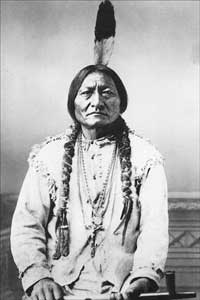
The Lakota are a Native American people. Also known as the Teton Sioux, they are one of the three prominent subcultures of the Sioux people, with the Eastern Dakota (Santee) and Western Dakota (Wičhíyena). Their current lands are in North and South Dakota. They speak Lakȟótiyapi—the Lakota language, the westernmost of three closely related languages that belong to the Siouan language family.

<span class="mw-page-title-main">Indian Territory</span> Evolving areas set aside by the US government for relocation of Native Americans

Indian Territory and the Indian Territories are terms that generally described an evolving land area set aside by the United States government for the relocation of Native Americans who held original Indian title to their land as a sovereign independent state. The concept of an Indian territory was an outcome of the U.S. federal government's 18th- and 19th-century policy of Indian removal. After the American Civil War (1861–1865), the policy of the U.S. government was one of assimilation.

<span class="mw-page-title-main">Iowa people</span> Native American Siouan people

The Iowa, also known as Ioway, and the Bah-Kho-Je or Báxoje are a Native American Siouan people. Today, they are enrolled in either of two federally recognized tribes, the Iowa Tribe of Oklahoma and the Iowa Tribe of Kansas and Nebraska.

<span class="mw-page-title-main">Treaty of Fort Laramie (1868)</span> US-Sioux treaty ending Red Clouds War

The Treaty of Fort Laramie is an agreement between the United States and the Oglala, Miniconjou, and Brulé bands of Lakota people, Yanktonai Dakota, and Arapaho Nation, following the failure of the first Fort Laramie treaty, signed in 1851.

<span class="mw-page-title-main">Otoe</span> Native American people of the Midwestern United States

The Otoe are a Native American people of the Midwestern United States. The Otoe language, Chiwere, is part of the Siouan family and closely related to that of the related Iowa, Missouria, and Ho-Chunk tribes.

<span class="mw-page-title-main">Ponca</span> Plains Native American tribe

The Ponca are a Midwestern Native American tribe of the Dhegihan branch of the Siouan language group. There are two federally recognized Ponca tribes: the Ponca Tribe of Nebraska and the Ponca Tribe of Indians of Oklahoma. Their oral history states they originated as a tribe east of the Mississippi River in the Ohio River valley area and migrated west for game and as a result of Iroquois wars.

<span class="mw-page-title-main">Omaha people</span> Native American tribe

The Omaha are a federally recognized Midwestern Native American tribe who reside on the Omaha Reservation in northeastern Nebraska and western Iowa, United States. There were 5,427 enrolled members as of 2012. The Omaha Reservation lies primarily in the southern part of Thurston County and northeastern Cuming County, Nebraska, but small parts extend into the northeast corner of Burt County and across the Missouri River into Monona County, Iowa. Its total land area is 307.03 sq mi (795.2 km2) and the reservation population, including non-Native residents, was 4,526 in the 2020 census. Its largest community is Pender.

<span class="mw-page-title-main">Iowa Tribe of Oklahoma</span> One of two federally recognized tribes for the Iowa people

The Iowa Tribe of Oklahoma is one of two federally recognized tribes for the Iowa people. The other is the Iowa Tribe of Kansas and Nebraska. Traditionally Iowas spoke the Chiwere language, part of the Siouan language family. Their own name for their tribe is Bahkhoje, meaning, "grey snow," a term inspired by the tribe's traditional winter lodges covered with snow, stained grey from hearth fires.

<span class="mw-page-title-main">Joseph LaFlesche</span>

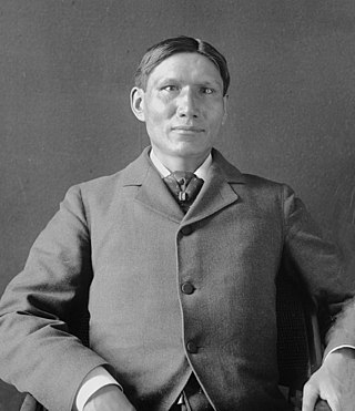
Joseph LaFlesche, also known as E-sta-mah-za or Iron Eye (1822–1888), was the last recognized head chief of the Omaha tribe of Native Americans who was selected according to the traditional tribal rituals. The head chief Big Elk had adopted LaFlesche as an adult into the Omaha and designated him in 1843 as his successor. LaFlesche was of Ponca and French Canadian ancestry; he became a chief in 1853, after Big Elk's death. An 1889 account said that he had been the only chief among the Omaha to have known European ancestry.

<span class="mw-page-title-main">Dakota people</span> Native American people in the mid northern U.S. and mid southern Canada

The Dakota are a Native American tribe and First Nations band government in North America. They compose two of the three main subcultures of the Sioux people, and are typically divided into the Eastern Dakota and the Western Dakota.

<span class="mw-page-title-main">Ponca Tribe of Indians of Oklahoma</span>

The Ponca Tribe of Indians of Oklahoma, also known as the Ponca Nation, is one of two federally recognized tribes of Ponca people. The other is the Ponca Tribe of Nebraska. Traditionally, peoples of both tribes have spoken the Omaha-Ponca language, part of the Siouan language family. They share many common cultural norms and characteristics with the Omaha, Osage, Kaw, and Quapaw peoples.

A Half-Breed Tract was a segment of land designated in the western states by the United States government in the 19th century specifically for Métis of American Indian and European or European-American ancestry, at the time commonly known as half-breeds. The government set aside such tracts in several parts of the Midwestern prairie region, including in Iowa Territory, Nebraska Territory, Kansas Territory, Minnesota Territory, and Wisconsin Territory.

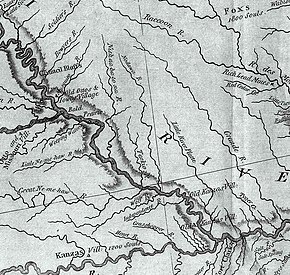
The Nemaha Half-Breed Reservation was established by the Fourth Treaty of Prairie du Chien of 1830, which set aside a tract of land for the mixed-ancestry descendants of French-Canadian trappers and women of the Oto, Iowa, and Omaha, as well as the Yankton and Santee Sioux tribes.

The Niobrara Reservation is a former Indian Reservation in northeast Nebraska. It originally comprised lands for both the Santee Sioux and the Ponca, both Siouan-speaking tribes, near the mouth of the Niobrara River at its confluence with the Missouri River. In the late nineteenth century the United States government built a boarding school at the reservation for the Native American children in the region. By 1908 after allotment of plots to individual households of the tribes under the Dawes Act, 1,130.7 acres (4.576 km2) were reserved for an agency, school and mission for a distinct Santee Sioux Reservation; the neighboring Ponca Reservation had only 160 acres (0.65 km2) reserved for agency and school buildings.

<span class="mw-page-title-main">Omaha Reservation</span> Indian reservation in United States, Omaha

The Omaha Reservation of the federally recognized Omaha tribe is located mostly in Thurston County, Nebraska, with sections in neighboring Cuming and Burt counties, in addition to Monona County in Iowa. As of the 2020 federal census, the reservation population was 4,526. The tribal seat of government is in Macy. The villages of Rosalie, Pender and Walthill are located within reservation boundaries, as is the northernmost part of Bancroft. Due to land sales in the area since the reservation was established, Pender has disputed tribal jurisdiction over it, to which the Supreme Court ruled unanimously in 2016 that "the disputed land is within the reservation’s boundaries."

<span class="mw-page-title-main">Winnebago Reservation</span> Indian reservation in United States, Winnebago

The Winnebago Reservation of the Winnebago Tribe of Nebraska is located in Thurston County, Nebraska, United States. The tribal council offices are located in the town of Winnebago. The villages of Emerson, south of First Street, as well as Thurston, are also located on the reservation. The reservation occupies northern Thurston County, Nebraska, as well as southeastern Dixon County and Woodbury County, Iowa, and a small plot of off-reservation land of southern Craig Township in Burt County, Nebraska. The other federally recognized Winnebago tribe is the Ho-Chunk Nation of Wisconsin.

<span class="mw-page-title-main">Sac and Fox Nation of Missouri in Kansas and Nebraska</span> Sauk and Meskwaki tribe based in Kansas

The Sac and Fox Nation of Missouri in Kansas and Nebraska is one of three federally recognized Native American tribes of Sac and Meskwaki (Fox) peoples. Their name for themselves is Nemahahaki and they are an Algonquian people and Eastern Woodland culture.

The fourth Treaty of Prairie du Chien was negotiated between the United States and the Sac and Fox, the Mdewakanton, Wahpekute and Sisseton Sioux, Omaha, Ioway, Otoe and Missouria tribes. The treaty was signed on July 15, 1830, with William Clark and Willoughby Morgan representing the United States. Through additional negotiations conducted in St. Louis on October 13, 1830, Yankton Sioux and Santee Sioux agreed to abide by the 1830 Treaty of Prairie du Chien. The US government announced the treaty and its numerous adherents on February 24, 1831.

References

  1. Swanton, J.R. (1952) The Indian Tribes of North America. Washington, DC: General Printing Office. p 283.
  2. "Nebraska Quickfacts" Archived 2012-10-14 at the Wayback Machine , U.S. Census. Retrieved 6/28/08.
  3. Andersen, J.D. (2001) The Four Hills of Life: Northern Arapaho Knowledge and Life Movement. Lincoln: University of Nebraska Press.
  4. Deetz, J. (1965) "The Dynamics of Stylistic Change in Arikara Ceramics", Illinois Studies in Anthropology No. 4. University of Illinois Press, Urbana.
  5. Morton, J.S. (1918) History of Nebraska. Western Publishing and Engraving Company. p 29.
  6. Swanton, J.R. (1952) p 283.
  7. DeMallie, R.J. (2001a). "Sioux until 1850", in Handbook of North American Indians: Plains. Volume 13, Part 2. Washington, D.C.: Smithsonian Institution. p 740.
  8. DeMallie, R.J. (2001b). "Teton", in Handbook of North American Indians: Plains. Volume 13, Part 2. Washington, D.C.: Smithsonian Institution. p 810.
  9. Fletcher, A.C. (1885) Historical Sketch of the Omaha Tribe of Indians in Nebraska. Washington: Judd & Detweiler.
  10. Swanton, J.R. (1952) p 264.
  11. "History", Winnebago Tribe of Nebraska. Retrieved 6/27/08. Archived May 16, 2008, at the Wayback Machine
  12. "Fort Atkinson State Historical Park" Archived 2008-10-07 at the Wayback Machine , Nebraska Economic Development Council. Retrieved 6/27/08.
  13. (1937) Corporate charter of the Sac and Fox Tribe of Missouri of the Sac and Fox Reservation in Kansas and Nebraska. United States Department of the Interior, Office of Indian Affairs. Retrieved 6/27/08.
  14. "Massacre Canyon Monument"
  15. "Tribes in Nebraska Give Up Lands in Treaties 1854 - 1857", NebraskaStudies.org. Retrieved 6/27/08.
  16. Logan Fontenelle Archived 2008-04-20 at the Wayback Machine . Nebraska Department of Education. Retrieved 6/22/07.
  17. 1 2 Royce, C.C. (1899) "Indian Land Cessions in the United States," in Powell, J.W. 18th Annual Report of the Bureau of American Ethnology to the Secretary of the Smithsonian Institution, 1896-97, Part 2. Washington, D.C.: Government Printing Office.
  18. (Laws of Nebraska, 1879-71, quoted in Sheldon 1936, 10-11.)
  19. "Native Americans meet challenges", NebraskaStudies.org. Retrieved 6/28/08.
  20. "Alphabetical List of Federally Recognized Native American Tribes", Retrieved 6/28/08.
  21. Fink, D. (1992) Agrarian Women: Wives and Mothers in Rural Nebraska, 1880-1940. University of North Carolina Press. p. 37.
  22. Fowler, L. (2005) The Columbia Guide to American Indians of the Great Plains. Columbia University Press. p. 201.
  23. "Nebraska Indian reservations", Retrieved 6/28/08.
  24. Santee Sioux Archived 2007-07-29 at the Wayback Machine , Nebraska Indian Commission. Retrieved 6/28/08.
  25. "Brancroft, Cuming County" Archived 2008-10-07 at the Wayback Machine , University of Nebraska. Retrieved 6/28/08.
  26. "Omaha Tribe" Archived 2007-07-29 at the Wayback Machine , Nebraska Indian Commission. Retrieved 6/28/08.
  27. "Ponca Tribe" Archived 2007-07-29 at the Wayback Machine , Nebraska Indian Commission. Retrieved 6/28/08.
  28. "Winnebago Tribe" Archived 2007-07-29 at the Wayback Machine , Nebraska Indian Commission. Retrieved 6/28/08.
  29. "Half-Breed Tract" [Usurped!], Nebraska State Historical Society. Retrieved 1/28/08.
  30. Foster, L.M. (1965) "The Nemaha Half-Breed Reservation, 1830-1860", Ioway Cultural Institute. Retrieved 1/28/08.
  31. "Barada" Archived 2011-07-20 at the Wayback Machine , University of Nebraska-Lincoln. Retrieved 1/28/08.
  32. (2007) "Nebraska Taxation of Native American Reservation Indians", Nebraska Department of Revenue. Retrieved 6/29/08.
  33. Nebraska Indian Tribes. Retrieved 8/17/08.
  34. Schulte, Grant (9 February 2012). "Tribe suing beer companies for alcohol problems". Boston Globe. Associated Press. Retrieved 9 February 2012.
  35. KEVIN ABOUREZK, "Winnebago business leader: Poverty at heart of Whiteclay debacle", Lincoln Journal Star, 7 April 2010, accessed 29 February 2012