Related Research Articles

Indian Territory and the Indian Territories are terms that generally described an evolving land area set aside by the United States government for the relocation of Native Americans who held original Indian title to their land as an independent nation-state. The concept of an Indian territory was an outcome of the U.S. federal government's 18th- and 19th-century policy of Indian removal. After the American Civil War (1861–1865), the policy of the U.S. government was one of assimilation.

The Iowa, also known as Ioway, and the Bah-Kho-Je or Báxoje, are a Native American Siouan people. Today, they are enrolled in either of two federally recognized tribes, the Iowa Tribe of Oklahoma and the Iowa Tribe of Kansas and Nebraska.

The Otoe are a Native American people of the Midwestern United States. The Otoe language, Chiwere, is part of the Siouan family and closely related to that of the related Iowa, Missouria, and Ho-Chunk tribes.

The Ponca people are a nation primarily located in the Great Plains of North America that share a common Ponca culture, history, and language, identified with two Indigenous nations: the Ponca Tribe of Indians of Oklahoma or the Ponca Tribe of Nebraska.
The Omaha Tribe of Nebraska are a federally recognized Midwestern Native American tribe who reside on the Omaha Reservation in northeastern Nebraska and western Iowa, United States. There were 5,427 enrolled members as of 2012. The Omaha Reservation lies primarily in the southern part of Thurston County and northeastern Cuming County, Nebraska, but small parts extend into the northeast corner of Burt County and across the Missouri River into Monona County, Iowa. Its total land area is 307.03 sq mi (795.2 km2) and the reservation population, including non-Native residents, was 4,526 in the 2020 census. Its largest community is Pender.

Joseph LaFlesche, also known as E-sta-mah-za or Iron Eye, was the last recognized head chief of the Omaha tribe of Native Americans who was selected according to the traditional tribal rituals. The head chief Big Elk had adopted LaFlesche as an adult into the Omaha and designated him in 1843 as his successor. LaFlesche was of Ponca and French Canadian ancestry; he became a chief in 1853, after Big Elk's death. An 1889 account said that he had been the only chief among the Omaha to have known European ancestry.

The Otoe–Missouria Tribe of Indians is a federally recognized tribe, located in Oklahoma. The tribe is made up of Otoe and Missouria peoples. Their language, the Chiwere language, is part of the Siouan language family.
The timeline of Kansas details past events that happened in what is present day Kansas. Located on the eastern edge of the Great Plains, the U.S. state of Kansas was the home of sedentary agrarian and hunter-gatherer Native American societies, many of whom hunted American bison. The region first appears in western history in the 16th century at the time of the Spanish conquest of the Aztec Empire, when Spanish conquistadors explored the unknown land now known as Kansas. It was later explored by French fur trappers who traded with the Native Americans. It became part of the United States in the Louisiana Purchase of 1803. In the 19th century, the first American explorers designated the area as the "Great American Desert."
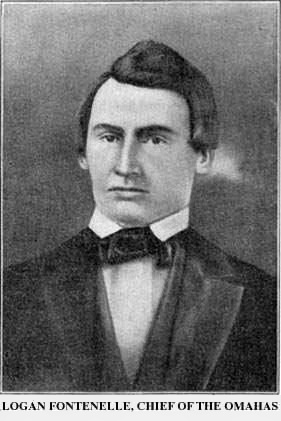
Logan Fontenelle, also known as Shon-ga-ska, was a trader of Omaha and French ancestry, who served for years as an interpreter to the US Indian agent at the Bellevue Agency in Nebraska. He was especially important during the United States negotiations with Omaha leaders in 1853–1854 about ceding land to the United States prior to settlement on a reservation. His mother was a daughter of Big Elk, the principal chief, and his father was a respected French-American fur trader.
A Half-Breed Tract was a segment of land designated in the western states by the United States government in the 19th century specifically for Métis of American Indian and European or European-American ancestry, at the time commonly known as half-breeds. The government set aside such tracts in several parts of the Midwestern prairie region, including in Iowa Territory, Nebraska Territory, Kansas Territory, Minnesota Territory, and Wisconsin Territory.

Native American tribes in the U.S. state of Nebraska have been Plains Indians, descendants of succeeding cultures of indigenous peoples who have occupied the area for thousands of years. More than 15 historic tribes have been identified as having lived in, hunted in, or otherwise occupied territory within the current state boundaries.
The Nemaha Half-Breed Reservation was established by the Fourth Treaty of Prairie du Chien of 1830, which set aside a tract of land for the mixed-ancestry descendants of French-Canadian trappers and women of the Oto, Iowa, and Omaha, as well as the Yankton and Santee Sioux tribes.
The Otoe Reservation was a twenty-four square-mile section straddling the Kansas-Nebraska state line. The majority of the reservation sat in modern-day southeast Jefferson County, Nebraska.
Several Native American tribes hold or have held territory within the lands that are now the state of Iowa.

Pahuk, also written Pahaku, or Pahuk Hill, is a bluff on the Platte River in eastern Nebraska in the United States. In the traditional Pawnee religion, it was one of five dwellings of spirit animals with miraculous powers. The Pawnee occupied three villages near Pahuk in the decade prior to their removal to the Pawnee Reservation on the Loup River in 1859.

St. Deroin is a ghost town in Nemaha County, Nebraska, United States, originally located below the river bluffs on the Missouri River. Formally chartered in 1854, the town had a popular ferry crossing over the Missouri River for more than three decades. The river changed course, ending the ferry. After a railroad spur bypassed the town, it drew off more commerce. The community rebuilt its school on the river bluff when it was threatened by flooding; this area was also used for the cemetery. The town was completely abandoned by 1920, as flooding had destroyed much of the townsite. The site is at the northern edge of Indian Cave State Park.

The Cherokee Commission, was a three-person bi-partisan body created by President Benjamin Harrison to operate under the direction of the Secretary of the Interior, as empowered by Section 14 of the Indian Appropriations Act of March 2, 1889. Section 15 of the same Act empowered the President to open land for settlement. The Commission's purpose was to legally acquire land occupied by the Cherokee Nation and other tribes in the Oklahoma Territory for non-indigenous homestead acreage.

French people have been present in the U.S. state of Nebraska since before it achieved statehood in 1867. The area was originally claimed by France in 1682 as part of La Louisiane, the extent of which was largely defined by the watershed of the Mississippi River and its tributaries. Over the following centuries, explorers of French ethnicity, many of them French-Canadian, trapped, hunted, and established settlements and trading posts across much of the northern Great Plains, including the territory that would eventually become Nebraska, even in the period after France formally ceded its North American claims to Spain. During the 19th century, fur trading gave way to settlements and farming across the state, and French colonists and French-American migrants continued to operate businesses and build towns in Nebraska. Many of their descendants continue to live in the state.
The fourth Treaty of Prairie du Chien was negotiated between the United States and the Sac and Fox, the Mdewakanton, Wahpekute and Sisseton Sioux, Omaha, Ioway, Otoe and Missouria tribes. The treaty was signed on July 15, 1830, with William Clark and Willoughby Morgan representing the United States. Through additional negotiations conducted in St. Louis on October 13, 1830, Yankton Sioux and Santee Sioux agreed to abide by the 1830 Treaty of Prairie du Chien. The US government announced the treaty and its numerous adherents on February 24, 1831.
References
- ↑ The Journal of American Indian Family Research. Vol. I, No. 4. Larry S. Watson, Editor. p 13-16.
- ↑ NRHS sites in Richardson County [usurped] , Nebraska State Historical Society.
- ↑ The Journal of American Indian Family Research. Vol. I, No. 4. Larry S. Watson, Editor. p 13-16.
- 1 2 Judith A. Boughter, Betraying the Omaha Nation, 1790-1916, University of Oklahoma Press, 1998, pp. 61-63
- ↑ Melvin Randolph Gilmore, "The True Logan Fontenelle", Publications of the Nebraska State Historical Society, Vol. 19, edited by Albert Watkins, Nebraska State Historical Society, 1919, p. 64, at GenNet, accessed 25 August 2011
- ↑ The Journal of American Indian Family Research. Vol. I, No. 4. Larry S. Watson, Editor. p 13-16.
- ↑ The Journal of American Indian Family Research. Vol. I, No. 4. Larry S. Watson, Editor. p 13-16.
- ↑ "Great Nemaha Indian Agency (Kansas)", Indian Agencies, Family Search, accessed 6 December 2011