
Fort Snelling is a former military fortification and National Historic Landmark in the U.S. state of Minnesota on the bluffs overlooking the confluence of the Minnesota and Mississippi Rivers. The military site was initially named Fort Saint Anthony, but it was renamed Fort Snelling once its construction was completed in 1825.

Crazy Horse was a Lakota war leader of the Oglala band in the 19th century. He took up arms against the United States federal government to fight against encroachment by white American settlers on Native American territory and to preserve the traditional way of life of the Lakota people. His participation in several famous battles of the Black Hills War on the northern Great Plains, among them the Fetterman Fight in 1866, in which he acted as a decoy, and the Battle of the Little Bighorn in 1876, in which he led a war party to victory, earned him great respect from both his enemies and his own people.

Fort Ridgely was a frontier United States Army outpost from 1851 to 1867, built 1853–1854 in Minnesota Territory. The Sioux called it Esa Tonka. It was located overlooking the Minnesota river southwest of Fairfax, Minnesota. Half of the fort's land was part of the south reservation in the Minnesota river valley for the Mdewakanton and Wahpekute tribes. Fort Ridgely had no defensive wall, palisade, or guard towers. The Army referred to the fort as the "New Post on the Upper Minnesota" until it was named for three Maryland Army Officers named Ridgely, who died during the Mexican–American War.

Fort Robinson is a former U.S. Army fort and now a major feature of Fort Robinson State Park, a 22,000-acre (8,900 ha) public recreation and historic preservation area located 2 miles (3.2 km) west of Crawford on U.S. Route 20 in the Pine Ridge region of northwest Nebraska.

Fort Atkinson was the first United States Army post to be established west of the Missouri River in the unorganized region of the Louisiana Purchase of the United States. Located just east of present-day Fort Calhoun, Nebraska, the fort was erected in 1819 and abandoned in 1827. The site is now known as Fort Atkinson State Historical Park and is a National Historic Landmark. A replica fort was constructed by the state at the site during the 1980s–1990s.

Fort Supply was a United States Army post established on November 18, 1868, in Indian Territory to protect the Southern Plains. It was located just east of present-day Fort Supply, Oklahoma, in what was then the Cherokee Outlet.

Touch the Clouds was a chief of the Minneconjou Teton Lakota known for his bravery and skill in battle, physical strength and diplomacy in counsel. The youngest son of Lone Horn, he was brother to Spotted Elk, Frog, and Roman Nose. There is evidence suggesting that he was a cousin to Crazy Horse.
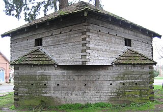
Fort Yamhill was an American military fortification in the state of Oregon. Built in 1856 in the Oregon Territory, it remained an active post until 1866. The Army outpost was used to provide a presence next to the Grand Ronde Agency Coastal Reservation. Several officers stationed at the United States Army post prior to the American Civil War would later serve as generals in that war.

Fort Omaha, originally known as Sherman Barracks and then Omaha Barracks, is an Indian War-era United States Army supply installation. Located at 5730 North 30th Street, with the entrance at North 30th and Fort Streets in modern-day North Omaha, Nebraska, the facility is primarily occupied by Metropolitan Community College. A Navy Operational Support Center and Marine Corps Reserve unit, along with an Army Reserve unit occupy the periphery of the 82.5 acres (33.4 ha) fort. The government deeded all but four parcels of the land to Metropolitan Community College in 1974.
A private in the Fourth Infantry, Charles Howard served as photographer for the Stanton Expedition in 1877, traveling throughout eastern Wyoming, western Nebraska and into the Black Hills of Dakota Territory.

Fontenelle Forest is a 1,400-acre (6 km2) forest, located in Bellevue, Nebraska. Its visitor features include hiking trails, a nature center, children's camps, a gift shop, and picnic facilities. The forest is listed as a National Natural Landmark and a National Historic District. The forest includes hardwood deciduous forest, extensive floodplain, loess hills, and marshlands.

The Great Sioux War of 1876, also known as the Black Hills War, was a series of battles and negotiations that occurred in 1876 and 1877 in an alliance of Lakota Sioux and Northern Cheyenne against the United States. The cause of the war was the desire of the US government to obtain ownership of the Black Hills. Gold had been discovered in the Black Hills, settlers began to encroach onto Native American lands, and the Sioux and the Cheyenne refused to cede ownership. Traditionally, American military and historians place the Lakota at the center of the story, especially because of their numbers, but some Native Americans believe the Cheyenne were the primary target of the American campaign.

Fort Arbuckle was constructed by the US Army in 1850 to counter raids by Plains Indian tribes on immigrant trains heading west to California and on the settlements of Choctaw and Chickasaw nations in Indian Territory.
William Gentles (c.1830–1878) was a private in the U.S. Army who is generally acknowledged as the soldier who bayoneted the Oglala war leader Crazy Horse in 1877.
The Sidney Black Hills Stage Road or Route was a trail connecting Sidney, Nebraska, Sidney Barracks, and the Union Pacific Railroad with Fort Robinson, Red Cloud Agency, Spotted Tail Agency, Custer City, Dakota Territory, and Deadwood, Dakota Territory between 1876 and 1887, when it was replaced.

This is a list of the National Register of Historic Places listings in Sheridan County, Nebraska.

Fort Clark was a frontier fort located just off U.S. Route 90 near Brackettville, in Kinney County, Texas, United States. It later became the headquarters for the 2nd Cavalry Division. The Fort Clark Historic District was added to the National Register of Historic Places on December 6, 1979. The Commanding Officer's Quarters at Fort Clark were designated a Recorded Texas Historic Landmark in 1988. The Fort Clark Guardhouse became a Recorded Texas Historic Landmark in 1962. The Fort Clark Officers' Row Quarters were designated a Recorded Texas Historic Landmark in 1991.
Fort Niobrara (1880–1906) was a military post located in north central Nebraska.

The Philip H. Sheridan Reserve Center is the former Fort Sheridan now in Lake Forest, Highwood, and Highland Park in Lake County, Illinois, United States. It was originally established as a United States Army Post named after Civil War Cavalry General Philip Sheridan, to honor his services to Chicago. When the main fort was officially closed by the Army on May 3, 1993, the majority of the property was sold by the Department of Defense to commercial land developers. Most of the original housing structures were then refurbished and resold as a residential community. Other buildings were given to cultural organizations like Midwest Young Artists, the largest youth music program in the Midwest. Approximately 90 acres (36 ha) of the southern end of the original post were retained by the Army; there the Army now operates the Sheridan Reserve Center complex.


