Effigy Mounds National Monument preserves more than 200 prehistoric mounds built by pre-Columbian Mound Builder cultures, mostly in the first millennium AD, during the later part of the Woodland period of pre-Columbian North America. Numerous effigy mounds are shaped like animals, including bears and birds.

Gage County is a county in the U.S. state of Nebraska. As of the 2010 United States Census, the population was 22,311. Its county seat is Beatrice. The county was created in 1855 and organized in 1857. It was formed from land taken from the Otoe in an 1854 treaty. The county was named for W. D. Gage, a Methodist minister.

Scotts Bluff National Monument is located west of the City of Gering in western Nebraska, United States. This National Park Service site protects over 3,000 acres of historic overland trail remnants, mixed-grass prairie, rugged badlands, towering bluffs and riparian area along the North Platte River. The park boasts over 100,000 annual visitors.

The Wupatki National Monument is a United States National Monument located in north-central Arizona, near Flagstaff. Rich in Native American archaeological sites, the monument is administered by the National Park Service in close conjunction with the nearby Sunset Crater Volcano National Monument. Wupatki was established as a national monument in 1924 and was listed on the National Register of Historic Places on October 15, 1966. The listing included three contributing buildings and 29 contributing structures on 35,422 acres (14,335 ha).

Agate Fossil Beds National Monument is a U.S. National Monument near Harrison, Nebraska. The main features of the monument are a valley of the Niobrara River and the fossils found on Carnegie Hill and University Hill.

The Aztec Ruins National Monument in northwestern New Mexico, USA consists of preserved structures constructed by the Pueblo Indians. The national monument lies on the western bank of the Animas River in Aztec, New Mexico, about 12 miles (19 km) northeast of Farmington. Additional Puebloan structures can be found in Salmon Ruins and Heritage Park, about 9.5 miles (15.3 km) south. Archaeological evidence puts the construction of the ruins in the 12th and 13th centuries. The Puebloan-built ruins were dubbed the "Aztec Ruins" by 19th century American settlers who misattributed their construction to the Aztecs.

The George Washington Birthplace National Monument is a national monument in Westmoreland County, Virginia, United States. This site was a colonial tobacco plantation developed by Englishman John Washington in the mid-17th century. John Washington was a great-grandfather of George Washington, general of the Continental Army and first president of the United States of America. George Washington was born in this house on February 22, 1732. He lived here until age three, returning later to live here as a teenager.
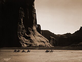
Canyon de Chelly National Monument was established on April 1, 1931, as a unit of the National Park Service. Located in northeastern Arizona, it is within the boundaries of the Navajo Nation and lies in the Four Corners region. Reflecting one of the longest continuously inhabited landscapes of North America, it preserves ruins of the indigenous tribes that lived in the area, from the Ancestral Puebloans to the Navajo. The monument covers 83,840 acres and encompasses the floors and rims of the three major canyons: de Chelly, del Muerto, and Monument. These canyons were cut by streams with headwaters in the Chuska Mountains just to the east of the monument. None of the land is federally owned. Canyon de Chelly is one of the most visited national monuments in the United States.
Homestead National Historical Park, a unit of the National Park System known as the Homestead National Monument of America prior to 2021, commemorates passage of the Homestead Act of 1862, which allowed any qualified person to claim up to 160 acres (0.65 km2) of federally owned land in exchange for five years of residence and the cultivation and improvement of the property. The Act eventually transferred 270,000,000 acres (1,100,000 km2) from public to private ownership.

The National Register of Historic Places in the United States is a register including buildings, sites, structures, districts, and objects. The Register automatically includes all National Historic Landmarks as well as all historic areas administered by the U.S. National Park Service. Since its introduction in 1966, more than 90,000 separate listings have been added to the register.
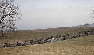
Antietam National Battlefield is a National Park Service-protected area along Antietam Creek in Sharpsburg, Washington County, northwestern Maryland. It commemorates the American Civil War Battle of Antietam that occurred on September 17, 1862.
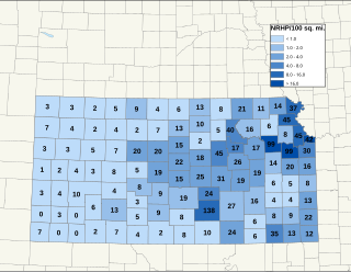
There are over 1,400 buildings, sites, districts, and objects in Kansas listed on the National Register of Historic Places in Kansas. NRHP listings appear in 101 of the state's 105 counties.

This is a list of more than 1,100 properties and districts in Nebraska that are on the National Register of Historic Places. Of these, 20 are National Historic Landmarks. There are listings in 90 of the state's 93 counties.

Monument Hill and Kreische Brewery State Historic Sites is a historic state park located at 29.888° -96.876°, just off U.S. Route 77, south of La Grange, Texas. The park sits on a sandstone bluff above the Colorado River. Monument Hill is a crypt and memorial to the men who died in the Dawson Massacre and in the Black Bean Episode of the ill-fated Mier Expedition.

This is a list of the National Register of Historic Places listings in McPherson County, Kansas.

The Pawnee Indian Museum State Historic Site, designated by the Smithsonian trinomial 14RP1, is an archaeological site and museum located near the city of Republic in the state of Kansas in the Midwestern United States. It is listed in the National Register of Historic Places under the name Pawnee Indian Village Site.

The Marais des Cygnes Massacre Site, also known as Marais des Cygnes Massacre Memorial Park, is a state historic site near Trading Post, Kansas that commemorates the 1858 massacre of the same name. On May 19, 1858, during a period of political instability and sporadic violence known as Bleeding Kansas, a group of pro-slavery border ruffians captured 11 abolitionist free-staters. The prisoners were forced to a nearby ravine, where 10 of them were shot, resulting in five fatalities. The abolitionist John Brown later built a fort near the site. The first commemoration at the site was two stone markers erected by men of the 3rd Iowa Cavalry Regiment in 1864, although these monuments had been destroyed by souvenir hunters by 1895. In 1941, the land where the massacre occurred, as well as an 1870s-era house constructed by a friend of Brown, were transferred to the state of Kansas. The site was listed on the National Register of Historic Places in 1971 and designated a National Historic Landmark in 1974. The Kansas Historical Society administers the site, which is interpreted by signage and a hand-cranked audio recording.

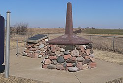
Site No. RH00-062 is a survey monument located at the tripoint of Richardson County, Nebraska, and Brown and Doniphan counties in Kansas. The cast iron monument is 6 feet (1.8 m) tall and 16 inches (410 mm) square at its base. The monument marks the starting point of the land survey of the Kansas-Nebraska border along the 40th parallel north, which intersects the top of the Missouri River's western bluff at this spot. U.S. Deputy Surveyor Charles A. Manners erected the monument in 1855 at the beginning of the survey. In 1924, the monument was displaced and reset at the wrong location before Leo M. Petersen reset it in a sturdier base.
OKKAMO Tri-State Marker is a monument showing the tripoint of Oklahoma, Kansas and Missouri. It is located at an elevation of 1,016 feet,(one source says 1,024 feet) and is located about 300 feet north of I-44 and about 1000 feet east of the Downstream Casino and Resort, that is operated by the Quapaw Nation.