
The Public Land Survey System (PLSS) is the surveying method developed and used in the United States to plat, or divide, real property for sale and settling. Also known as the Rectangular Survey System, it was created by the Land Ordinance of 1785 to survey land ceded to the United States by the Treaty of Paris in 1783, following the end of the American Revolution. Beginning with the Seven Ranges in present-day Ohio, the PLSS has been used as the primary survey method in the United States. Following the passage of the Northwest Ordinance in 1787, the Surveyor General of the Northwest Territory platted lands in the Northwest Territory. The Surveyor General was later merged with the General Land Office, which later became a part of the U.S. Bureau of Land Management (BLM). Today, the BLM controls the survey, sale, and settling of lands acquired by the United States.

The San Bernardino meridian, established in 1852, is one of three principal meridians in the state of California. Because of the state's shape, three meridian–baseline sets are required for surveys in all parts of the state. The San Bernardino meridian is used for Southern California, and some townships in Arizona are also referenced to it.

The Mount Diablo meridian, established in 1851, is a principal meridian extending north and south from its initial point atop Mount Diablo in California at W 121° 54.845. Established under the U.S. Public Land Survey System, it is used to describe lands in most of northern California and all of Nevada. Mount Diablo also marks the baseline at latitude 37°52′54″N.

The Humboldt meridian in California, longitude 124° 07' 10" west from Greenwich, intersects the base line on the summit of Mount Pierce at latitude 40° 25' 02" north, and governs the surveys in the northwestern corner of California, lying west of the Coast Range of mountains, and north of township 5 south, of the Humboldt meridian system. This principal meridian was established in 1853.

The first principal meridian is a meridian that began at the junction of the Ohio River and Great Miami River. It extends north on the boundary line between the states of Ohio and Indiana, and roughly approximates to the meridian of longitude 84° 48′ 50″ west from Greenwich. The ranges of the public surveys in the state of Ohio, west of the Scioto River, are numbered from this meridian.
The second principal meridian, or Paoli Meridian, coincides with 86° 28′ of longitude west from Greenwich, starts from a point two and one half miles west of the confluence of the Little Blue and Ohio rivers, runs north to the northern boundary of Indiana, and, with the base line in latitude 38° 28′ 20″, governs the surveys in Indiana and part of those in Illinois.
The fourth principal meridian, set in 1815, is the principal meridian for land surveys in northwestern Illinois and west-central Illinois, and its 1831 extension is the principal meridian for land surveys in Wisconsin and northeastern Minnesota. It is part of the Public Land Survey System that covers most of the United States.

The Fifth principal meridian, often denoted the "5th Meridian" or "PM 05," is a principal meridian survey line used in the United States for land claims in the Public Land Survey System (PLSS). It was first surveyed in 1815. The meridian, a north-south line, starts from the old mouth of the Arkansas River and runs north. Another survey line related to it is the base line running west from the old mouth of the St. Francis River. These survey lines govern all land surveys in four states and a large portion of the land surveys for two more. Monuments have been erected where the two lines meet at 34°38′44″N91°3′42″W, and the surveyors' skill has been commemorated at the Louisiana Purchase State Park in eastern Arkansas. The Fifth principal meridian is nearly coincident with 91° 3′ 42″ longitude west from the Greenwich meridian.

The Tallahassee meridian, in longitude 84° 16′ 37.59″ west from the prime meridian at Greenwich, runs north and south from the initial point on the base line at Tallahassee, in latitude 30° 26′ 04.12″ north, and as a principal meridian governs the surveys in Florida and Alabama as part of the Public Land Survey System.

The Saint Stephens meridian, in longitude 88° 02′ west from Greenwich, begins at the initial point, on the base line, in latitude 31° north, passes through Saint Stephens, Alabama, extends south to Mobile Bay and north to latitude 33° 06′ 20″, and governs the surveys in the southern district of Alabama, and in Pearl River district lying east of the river and south of the Choctaw Baseline, in latitude 31° 52′ 40″ north, in the state of Mississippi.
Saint Helena meridian begins at the initial point of the Washington meridian, in latitude 31° north, and longitude 91° 09′ 15″ west of Greenwich, passing one mile east of Baton Rouge, extends south to the Mississippi River, and governs the surveys in the Greensburg and southeastern districts of Louisiana, east of the Mississippi River.

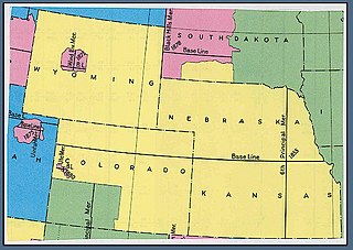
The Salt Lake meridian, established in 1855, in longitude 111° 54′ 00″ west from Greenwich, has its initial point at southeast corner of Temple Square, in Salt Lake City, Utah, extends north and south through the state, and, with the base line, through the initial, and coincident with the parallel of 40° 46′ 04″ north latitude, governs the surveys in the territory, except those referred to the Uintah meridian and Baseline projected from an initial point in latitude 40° 26′ 20″ north, longitude 109° 57′ 30″ west from Greenwich.
The Boise meridian is one of the 35 principal meridians of the Public Land Survey System of the United States. Adopted in 1867, its longitude is 116° 23′ 35″ west from Greenwich and its principal baseline is latitude 43° 22′ 21″ north. The meridian and baseline intersect approximately 19 miles (31 km) from Boise, between the Snake River and the Boise River. The Boise meridian governs land surveys in the state of Idaho.
The Gila and Salt River Meridian intersects the initial point on the south side of the Gila River, opposite the mouth of Salt River, at latitude 33° 22′ 37.82733″ north, longitude 112° 18′ 21.99931″ west from Greenwich based on NAD 83, and governs the surveys in the territory of Arizona. The current declination for the initial point is 12° east. It is located on Monument Hill, an easily visible hill just south of the confluence of the Gila and Salt Rivers, in Avondale, Arizona, about 14 miles southwest of downtown Phoenix.

The Indian meridian, in longitude 97° 14′ 30″ west from Greenwich, extends from Red River to the south boundary of Kansas, and, with the base line in latitude 34° 30′ north, governs the surveys in Oklahoma east of 100° west longitude from Greenwich.
The Navajo meridian, established in 1869, is one of the two principal meridians for Arizona, the other being the Gila and Salt River meridian. Its initial point was stated as latitude 35° 45' north, longitude 108° 32' 45" west from Greenwich, but has been revised as 35°44′56″N108°31′59″W The Navajo meridian and baseline were used to set townships and ranges in a special survey for the original Navajo Reservation, and was set at the eastern boundary of that reservation. The Arizona lands surveyed using the Navajo meridian and baseline were ranges six west to ten west and townships one north to fourteen north, and included Canyon de Chelly National Monument.
The Wind River meridian, established in 1875, is one of the principal meridians for Wyoming. The initial point is near Fort Washakie, Wyoming.
The Ute meridian, also known as the Grand River meridian, was established in 1880 and is a principal meridian of Colorado. The initial point lies inside the boundaries of Grand Junction Regional Airport, Grand Junction, Colorado.
The Washington Meridian is one of the 38 principal meridians governing cadastral surveys in the United States. The meridian line was surveyed and established in 1803 by surveyor Isaac Briggs. Briggs named the meridian the Washington Meridian, likely because the meridian passed near his offices in the community of Washington, Mississippi.


