Initial Point of Boundary Between U.S. and Mexico

Last updated
Initial Point of Boundary Between U.S. and Mexico
Monument marking the Initial Point of Boundary Between U.S. and Mexico (1974 photo).jpg
The monument in a 1974 photo
LocationS of Imperial Beach off Monument Rd., Imperial Beach, California
Coordinates 32°32′4″N117°7′19″W / 32.53444°N 117.12194°W / 32.53444; -117.12194
Area0.1 acres (0.040 ha)
Built1851 (1851)
Governing bodyFederal
DesignatedSeptember 6, 1974
Reference no.74000550 [1]
Location map Southern San Diego.png
Red pog.svg
location in Imperial Beach, California

The Initial Point of Boundary Between U.S. and Mexico (Monument No. 258) is the westernmost boundary marker on the international boundary between the United States and Mexico and as such has since its erection marked the southwestern corner of the Continental United States. [2] According to the 1848 Treaty of Guadalupe Hidalgo, the initial border point is set as one marine league (three nautical miles) south of the southernmost point of San Diego Bay, and the border proceeds in a straight line towards the confluence of the Colorado River and Gila River. [3]

Contents

The significance of the monument is stated in the inscription on the west side of the original marble shaft: [2]

"Initial point of Boundary between the United States and Mexico, established by the Joint Commission, 10 October, A.D. 1849, Agreeably to the Treaty dated at the City of Guadalupe, Hidalgo, February 2, A.D. 1848. John B. Weller, U.S. Commissioner. Andrew B. Gray, U.S. Surveyor.

History

The boundary marker was first established as a cairn of rocks in 1849 following the signing of the Treaty of Guadalupe Hidalgo. A white marble shaft was manufactured in New York, transported around Cape Horn on the USS Supply to San Diego, and erected and dedicated at the site in Imperial Beach in June, 1851. The marble monument was an obelisk about 20 feet (6 metres) in height, resting on a marble pedestal. On its top was an inverted acorn to symbolize the strength and stature of the California live oak tree. [2]

The monument in the 1890s Report of the Boundary commission upon the survey and re-marking of the boundary between the United States and Mexico west of the Rio Grande, 1891-1896 (1898) (14763270471).jpg
The monument in the 1890s

In 1894 it was found that the initial monument had become so mutilated by visitors that its outlines were nearly destroyed, and its inscriptions partly obliterated. The Barlow-Blanco Commission had the monument renovated in San Diego, reconstructed at the site, and protected with an enclosure in 1894. Excepting for normal wear and tear and some slight vandalism, as of 1974 the marble monument as reconstructed in 1894 still stood at its original site. [2]

Monument in 2017 seen from Friendship Park. Border monument seen through the US-Mexico barrier.jpg
Monument in 2017 seen from Friendship Park.

Pursuant to President Richard Nixon's "Legacy of Parks", Mrs. Pat Nixon in August 1971 turned over 372 acres (151 ha) of surplus Navy land, formerly known as Border Field, to the people of California as a beach park. The area is now known as Border Field State Park. [2]

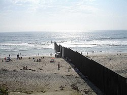
Prior to 1994, the US-Mexico border fence bisected the marker. In 1994, access to the marker was inhibited from the United States side by Operation Gatekeeper. [4] The current border fence passes several feet to the north of the marker, and it is possible to fully circumambulate the monument from Playas de Tijuana in Mexico, where it remains a popular attraction.

The border site in 2011 facing northeast from Mexico. The monument, now completely south of the border fence, can be seen in the background to the left of the Tijuana Lighthouse. TJLighthouse.jpg
The border site in 2011 facing northeast from Mexico. The monument, now completely south of the border fence, can be seen in the background to the left of the Tijuana Lighthouse.

See also

Related Research Articles

<span class="mw-page-title-main">Four Corners Monument</span> National monument in the Southwestern United States

The Four Corners Monument marks the quadripoint in the Southwestern United States where the states of Arizona, Colorado, New Mexico, and Utah meet. It is the only point in the United States shared by four states, leading to the area being named the Four Corners region. The monument also marks the boundary between two semi-autonomous Native American governments, the Navajo Nation, which maintains the monument as a tourist attraction, and the Ute Mountain Ute Tribe Reservation.

<span class="mw-page-title-main">Treaty of Guadalupe Hidalgo</span> 1848 agreement ending the Mexican–American War

The Treaty of Guadalupe Hidalgo officially ended the Mexican–American War (1846–1848). It was signed on 2 February 1848 in the town of Guadalupe Hidalgo.

<span class="mw-page-title-main">Baja California</span> State of Mexico

Baja California, officially Estado Libre y Soberano de Baja California, is a state in Mexico. It is the northernmost and westernmost of the 32 federal entities of Mexico. Before becoming a state in 1952, the area was known as the North Territory of Baja California. It has an area of 70,113 km2 (27,071 sq mi) and comprises the northern half of the Baja California Peninsula, north of the 28th parallel, plus oceanic Guadalupe Island. The mainland portion of the state is bordered on the west by the Pacific Ocean; on the east by Sonora, the U.S. state of Arizona, and the Gulf of California; on the north by the U.S. state of California; and on the south by Baja California Sur.

<span class="mw-page-title-main">Border Field State Park</span> State park in San Diego, California

Border Field State Park is a state park of California, United States, containing beach and coastal habitat on the Mexico–United States border. The park is within the city limits of Imperial Beach in San Diego County, next to the suburb of Playas de Tijuana in Mexico. It contains the southernmost point in the state of California. The refuge forms the southern part of the Tijuana River National Estuarine Research Reserve.

<span class="mw-page-title-main">Tijuana River</span> River in Mexico and California

The Tijuana River is an intermittent river, 120 mi (195 km) long, near the Pacific coast of northern Baja California state in northwestern Mexico and Southern California in the western United States. The river is heavily polluted with raw sewage from the city of Tijuana, Mexico.

<span class="mw-page-title-main">International Boundary and Water Commission</span>

The International Boundary and Water Commission is an international body created by the United States and Mexico in 1889 to apply the rules for determining the location of their international boundary when meandering rivers transferred tracts of land from one bank to the other, as established under the Convention of November 12, 1884.

<span class="mw-page-title-main">Mexico–United States border</span> International border in North America

The Mexico–United States border is an international border separating Mexico and the United States, extending from the Pacific Ocean in the west to the Gulf of Mexico in the east. The border traverses a variety of terrains, ranging from urban areas to deserts. The Mexico–U.S. border is the most frequently crossed border in the world with approximately 350 million documented crossings annually. Illegal crossing of the border to enter the United States has been a top issue in the States and is causing a border crisis. It is one of two international borders that the United States has, the other being the Canada–United States border to the north. It is the tenth-longest border between two countries in the world.

<span class="mw-page-title-main">Campo de Cahuenga</span> Historic house in California, United States

The Campo de Cahuenga, near the historic Cahuenga Pass in present-day Studio City, California, was an adobe ranch house on the Rancho Cahuenga where the Treaty of Cahuenga was signed between Lieutenant Colonel John C. Frémont and General Andrés Pico in 1847, ending hostilities in California between Mexico and the United States. The subsequent Treaty of Guadalupe Hidalgo of 1848, ceding California, parts of Colorado, Nevada, New Mexico, and Arizona to the United States, formally ended the Mexican–American War. From 1858 to 1861 the Campo de Cahuenga became a Butterfield Stage Station.

<span class="mw-page-title-main">San Diego–Tijuana</span> Transborder agglomeration of the Californias

San Diego–Tijuana is an international transborder agglomeration, straddling the border of the adjacent North American coastal cities of San Diego, California, United States, and Tijuana, Baja California, Mexico. The 2020 population of the region was 5,456,577, making it the largest bi-national conurbation shared between the United States and Mexico, and the second-largest shared between the US and another country. The conurbation consists of the San Diego metropolitan area, in the United States and the municipalities of Tijuana, Rosarito Beach (126,980), and Tecate (108,440) in Mexico. It is the third most populous region in the California–Baja California region, smaller only than the metropolitan areas of Greater Los Angeles and the San Francisco Bay Area.

<span class="mw-page-title-main">Ranchos of California</span> Land concessions by Spain and land grants by Mexico in the 18th and 19th centuries in California

The Spanish and Mexican governments made many concessions and land grants in Alta California and Baja California from 1775 to 1846. The Spanish Concessions of land were made to retired soldiers as an inducement for them to settle in the frontier. These Concessions reverted to the Spanish crown upon the death of the recipient.

The California Land Act of 1851, enacted following the Treaty of Guadalupe Hidalgo and the admission of California as a state in 1850, established a three-member Public Land Commission to determine the validity of prior Spanish and Mexican land grants. It required landowners who claimed title under the Mexican government to file their claim with a commission within two years. Contrary to the Treaty of Guadalupe Hidalgo, which guaranteed full protection of all property rights for Mexican citizens, it placed the burden on landholders to prove their title.

Rancho Guadalupe was a 43,682-acre (176.77 km2) Mexican land grant in present-day northwestern Santa Barbara County and southwestern San Luis Obispo County, California given in 1840 by Governor Juan B. Alvarado to Diego Olivera and Teodoro Arellanes. The grant extended along the Pacific coast, and encompassed present-day Guadalupe.

<span class="mw-page-title-main">Baja California Territory</span> Mexican territory from 1824-1853 and 1854-1931

Baja California Territory was a Mexican territory from 1824 to 1853, and 1854 to 1931, that encompassed the Baja California peninsula of present-day northwestern Mexico. It replaced the Baja California Province (1773–1824) of the Spanish colonial Viceroyalty of New Spain, after Mexican independence. Along with Alta California, the two territories were split from the Spanish Californias region.

Friendship Park is a half-acre (0.20 ha) binational park located along the United States-Mexico border in the San Diego–Tijuana region. Located within the larger Border Field State Park in California's San Diego county, the park includes the border fence dividing the two countries where residents of both countries can meet in person. On the U.S. side, the park used to be part of the Monument Mesa picnic area but is now wholly located on federal property under the Department of Homeland Security and is heavily monitored by U.S. Border Patrols 24 hours a day. To the south of this place is the Playas de Tijuana, Baja California. In 2022 the U.S. approved the construction of a wall, but announced soon after plans for the construction had been put on hold. In January 2023, it was announced that construction would proceed.

<span class="mw-page-title-main">United States and Mexican Boundary Commission</span>

The Joint United States and Mexican Boundary Commission was stipulated by the Treaty of Guadalupe Hidalgo which ended the Mexican–American War in 1848. The Joint Commission was required to carefully survey and mark the new boundary which had only been imprecisely described in the treaty between the two countries.

<span class="mw-page-title-main">Goat Canyon (Tijuana River Valley)</span> Canyon in the Mexican state of Baja California and the US state of California

Goat Canyon also known as Cañón de los Laureles, begins in Tijuana, Mexico, and ends in the United States just north of the Mexico–U.S. border. The canyon is formed by Goat Canyon Creek, which receives water and other runoff from areas south of the border. Most of the canyon and its watershed lies within Baja California.

<span class="mw-page-title-main">Smuggler's Gulch</span> Canyon located in the U.S. state of California and the Mexican state of Baja California

The Smuggler's Gulch is part of a steep walled canyon about 2 miles (3.2 km) inland of the Pacific Ocean. The canyon crosses the Mexico–United States border, between Tijuana, Baja California, and San Diego, California, and Smuggler's Gulch is the part of the canyon on the US side of the border. It may also be called Cañón del Matadero or Valle Montezuma in Spanish, but these names apply more generally to the whole canyon. Smuggling activities within Smuggler's Gulch have occurred since the 19th century, giving this part of the canyon its name.

Several Indigenous peoples who live on the United States–Mexico border have objected to the construction of a border wall on their territories and the militarization of the border by the United States government. The US–Mexico border crosses several Indigenous territories and divides these communities. The barrier erected between the United States and Mexico cuts through and/or affects at least 29 Indigenous tribes, which include Kumeyaay Nation and Tohono O'odham.

<span class="mw-page-title-main">Palóu Line</span>

The Palóu Line was the boundary between Alta California and Baja California, demarcated by Franciscan missionary, Francisco Palóu to distinguish Franciscan and Dominican areas of mission control during the Spanish colonial era.

References

  1. "National Register Information System". National Register of Historic Places . National Park Service. July 9, 2010.
  2. 1 2 3 4 5 Raney, Morris H. International Boundary and Water Commission, U.S. Section. Nomination form to the National Register of Historic Places (copied verbatim, allowed as per WP:PD, as the author is a federal employee acting in an official capacity)
  3. Levanetz, Joel. "A Compromised Country: Redefining the U.S.-Mexico Border" (PDF). San Diego History Center. Retrieved 2019-08-27.
  4. Zaragoza, Barbara (23 June 2015). "The San Diego-Tijuana Boundary Monuments". San Diego Free Press. Retrieved 2 May 2017.
    "Friendship Park and Boundary Monument 258". San Diego Compass. Barbara Zaragoza. 5 November 2014. Retrieved 2 May 2017.
    Zaragoza, Barbara (April 2015). "The San Diego-Tijuana Boundary Monuments". South Bay Historical Society Bulletin (8): 1–13. Retrieved 2 May 2017.