Tijuana is the largest city in the state of Baja California located on the northwestern Pacific Coast of Mexico. Tijuana is the municipal seat of the Tijuana Municipality and the hub of the Tijuana metropolitan area. It has a close proximity to the Mexico–United States border, which is part of the San Diego-Tijuana metro area.

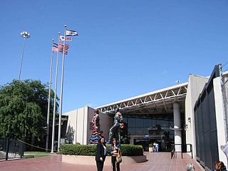
General Abelardo L. Rodríguez International Airport or simply Tijuana International Airport, is an international airport three miles northeast of Downtown Tijuana. It is the main International Airport in Tijuana, Baja California, Mexico, and serves the Metropolitan Area of San Diego-Tijuana. It is the fourth busiest in Mexico after Mexico City, Cancun, and Guadalajara airports, and Latin America's 13th-busiest airport. It handled 8,925,900 passengers in 2019, and 12,324,600 in 2022, becoming the fifth airport in the country to transport more than ten million passengers in a year. The airport can handle up to 10 million passengers per year and 360 flights per day.
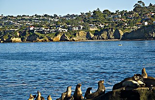
San Ysidro is a district of the City of San Diego, immediately north of the Mexico–United States border. It neighbors Otay Mesa West to the north, Otay Mesa to the east, and Nestor and the Tijuana River Valley to the west; together these communities form South San Diego, a practical exclave of the City of San Diego. Major thoroughfares include Beyer Boulevard and San Ysidro Boulevard.
Tecate is a city in Tecate Municipality, Baja California. It is across the Mexico–US border from Tecate, California. As of 2019, the city had a population of 108,860 inhabitants, while the metropolitan area has a population of 132,406 inhabitants. Tecate is part of the San Diego-Tijuana metropolitan area and the largest city between Tijuana and Mexicali. Tecate is a regional economic hub and popular tourist destination, known as home to the Tecate Port of Entry and to Tecate Beer.

Federal Highway 1 is a free (libre) part of the federal highway corridors of Mexico, and the highway follows the length of the Baja California Peninsula from Tijuana, Baja California, in the north to Cabo San Lucas, Baja California Sur, in the south. The road connects with Via Rapida, which merges into the American Interstate 5 (I-5) at the San Ysidro Port of Entry, which crosses the international border south of San Ysidro, California.
Otay Mesa is a community in the southern section of the city of San Diego, just north of the U.S.–Mexico border.
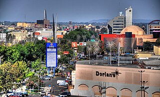
Zona Río is an official zone, and the main modern business district, of the city of Tijuana, Mexico.

Tijuana River National Estuarine Research Reserve is a natural reserve in Imperial Beach, California and San Ysidro, San Diego. It encompasses the Tijuana River Estuary, located on the Mexico–United States border. It is divided into two parts: the Tijuana Slough National Wildlife Refuge on the north, and Border Field State Park in the south.

The San Ysidro Port of Entry is the largest land border crossing between San Diego and Tijuana, and the fourth-busiest land border crossing in the world with 70,000 northbound vehicles and 20,000 northbound pedestrians crossing each day, in addition to southbound traffic. It connects Mexican Federal Highway 1 on the Mexican side with Interstate 5 on the American side. The San Ysidro Port of Entry is one of three ports of entry in the San Diego–Tijuana metropolitan region.
The Tijuana River Valley is a rural community in the southern section of San Diego, California. It neighbors Imperial Beach to the north and west, Egger Highlands and Nestor to the north, San Ysidro to the east, and the U.S.-Mexico border to the south. Major thoroughfares include Hollister Street, Monument Road, and Dairy Mart Road.
The Otay Mesa Port of Entry is one of three ports of entry (POE) in the San Diego–Tijuana metropolitan region, in the U.S. state of California, connecting Otay Mesa in the City of San Diego with the Otay Centenario borough of Tijuana. The facility was opened in 1983, and was constructed primarily to divert growing commercial truck traffic from the busy San Ysidro Port of Entry, located 5.2 miles (8.4 km) west. Since then, significant passenger vehicle and pedestrian traffic has grown as development in the area around the crossing has grown. Commercial importations through Otay Mesa accounts for billions of dollars' worth of freight.

The Tecate Port of Entry is one three ports of entry in the San Diego–Tijuana metropolitan region. The land port is located between Tecate, California in San Diego County's Mountain Empire and Tecate Municipality in Baja California. It connects California State Route 188 with Paseo Lázaro Cárdenas, a spur of Mexico Federal Highway 2, as well as Federal Highway 3 to the south. It is a minor port in comparison to the larger San Ysidro Port of Entry and Otay Mesa Port of Entry. This is attributed in part to the fact that reaching the crossing on the US side requires driving on narrow, winding mountain roads.
Friendship Park is a half-acre (0.20 ha) binational park located along the United States-Mexico border in the San Diego–Tijuana region. Located within the larger Border Field State Park in California's San Diego county, the park includes the border fence dividing the two countries where residents of both countries can meet in person. On the U.S. side, the park used to be part of the Monument Mesa picnic area but is now wholly located on federal property under the Department of Homeland Security and is heavily monitored by U.S. Border Patrols 24 hours a day. To the south of this place is the Playas de Tijuana, Baja California. In 2022 the U.S. approved the construction of a wall, but announced soon after plans for the construction had been put on hold. In January 2023, it was announced that construction would proceed.
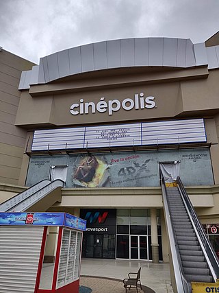
Plaza Río Tijuana is an open-air shopping center in the Zona Río of Tijuana, Baja California, Mexico. It has a surface area of 792,000 square feet (73,579 m2). It opened in 1981 as the first large American-style mall in the city; previously Downtown Tijuana was the leading shopping area. Currently, it has the anchors Soriana, Sears, and Cinépolis. There was a Dorian's department store here until 2009 when it became Sears. Comercial Mexicana was also in the mall until it became Soriana in 2018.
The following is a timeline of the history of the city of Tijuana, Baja California, Mexico.

Las Americas Premium Outlets is a 560,000 square feet (52,000 m2) outlet mall in San Ysidro, San Diego, California located directly on the Mexico–United States border just west of the San Ysidro Port of Entry at the new PedWest crossing from Tijuana to Virginia Avenue on the U.S. side.

The El Chaparral port of entry or border crossing is as of 2012 the main vehicle crossing point from San Diego into Tijuana, Mexico, replacing the former entry point known as Puerta México which stood immediately east of El Chaparral. It is part of the San Ysidro Port of Entry. It is roughly in the same location as the former Virginia Avenue crossing, where trucks entering the US from Mexico prior to 1983, was located. The opening of El Chaparral roughly tripled the number of traffic lanes to 22, reducing wait times for vehicles entering Mexico.

Cross Border Xpress (CBX), historically also called the Tijuana Cross-border Terminal and the Puerta de las Californias, is an airport terminal located in the Otay Mesa area of southern San Diego, California, United States, with an access bridge connecting it to the Tijuana International Airport in Tijuana, Baja California, Mexico. It opened on December 9, 2015. It makes Tijuana Airport a geographically binational airport. Unlike the binational airports serving the Swiss cities of Basel and Geneva, the CBX terminal is physically located in the United States but serves an airport whose main terminal and runways are in Mexico. A pedestrian bridge spans the United States–Mexico border and Via de la Juventud Oriente in Tijuana, connecting passenger terminals between the two countries. It was the creation of Ralph Nieders, who introduced the concept and infrastructure design in Mexico City in 1989 and San Diego in 1990. The structural scheme allows passengers originating in, and destined to the United States direct access to the Tijuana airport and equally gives Mexican and international carriers operating from the Tijuana airport direct access to the U.S. passenger market.

La Cinco y Diez, is the name of an intersection, pedestrian overpass over that intersection, public transportation hub and major retail district in La Mesa borough, Tijuana, Mexico. The name exists because a branch of the Luján/Cardenas family's "La Cinco y Diez" five and dime store once stood here, and Tijuana residents taking taxis or buses would ask to be let off by "La Cinco y Diez".