
The following are the principal and guide meridians and base lines of the United States, with the year established and a brief summary of what areas' land surveys are based on each.
The following are the principal and guide meridians and base lines of the United States, with the year established and a brief summary of what areas' land surveys are based on each.
Primarily from the United States Government Printing Office Style Manual. [1] State names usually signify only parts of each listed state, unless otherwise indicated.
Based on the BLM manual's 1973 publication date, and the reference to Clarke's Spheroid of 1866 in section 2-82, coordinates appear to be in the NAD27 datum.
| Meridian | Longitude | Associated Baseline | Latitude | Adopted | Area surveyed |
|---|---|---|---|---|---|
| First principal | 84°48′11″W | 40°59′22″N | 1819 [2] | Ohio (NW) | |
| Indiana (sliver of SE) | |||||
| Second principal | 86°27′21″W | 38°28′14″N | 1805 [2] | Illinois (far E) | |
| Indiana (almost all) | |||||
| Third principal | 89°08′54″W | Centralia | 38°28′27″N | 1805 [2] | Illinois (most) |
| Fourth principal | 90°27′11″W | Beardstown | 40°00′50″N | 1815 [2] | Illinois (W of Illinois River and 3rd principal meridian) |
| Fourth principal (extended) | 90°25′37″W | Illinois–Wisconsin border | 42°30′27″N | 1831 [2] | Minnesota (NE) |
| Wisconsin (all) | |||||
| Fifth principal | 91°03′07″W | 34°38′45″N | 1815 [3] | Arkansas (all) | |
| Iowa (all) | |||||
| Minnesota (most) | |||||
| Missouri (all) | |||||
| North Dakota (all) | |||||
| South Dakota (E half) | |||||
| Sixth principal | 97°22′08″W | 40°00′07″N | 1855 [4] | Colorado (most) | |
| Kansas (all) | |||||
| Nebraska (all) | |||||
| South Dakota (some of S) | |||||
| Wyoming (most) | |||||
| Black Hills | 104°03′16″W | Black Hills | 43°59′44″N | 1878 [3] | South Dakota (W) |
| Boise [1] | 116°23′35″W | 43°22′21″N | 1867 [5] | Idaho (all) | |
| Chickasaw | 89°14′47″W | 35°01′58″N | 1833 [6] | Mississippi | |
| Choctaw | 90°14′41″W | Choctaw | 31°52′32″N | 1821 [6] | Mississippi |
| Cimarron | 103°00′07″W | 36°30′05″N | 1881 [7] | Oklahoma (panhandle) | |
| Copper River | 145°18′37″W | 61°49′04″N | 1905 [8] | Alaska | |
| Fairbanks | 147°38′25.949″W | 64°51′50.048″N | 1910 [8] | Alaska | |
| Gila and Salt River | 112°18′19″W | 33°22′38″N | 1865 [9] | Arizona (most) | |
| Humboldt | 124°07′10″W | 40°25′02″N | 1853 [10] | California | |
| Huntsville | 86°34′16″W | 34°59′27″N | 1807 [6] | Alabama | |
| Mississippi | |||||
| Indian | 97°14′49″W | 34°29′32″N | 1870 | Oklahoma (most) [7] | |
| Kateel River | 158°45′31.014″W | 65°26′16.374″N | 1956 | Alaska [8] | |
| Louisiana | 92°24′55″W | 31°00′31″N | 1807 [6] | Louisiana | |
| Michigan | 84°21′53″W | 42°25′28″N | 1815 [2] | Michigan | |
| Ohio | |||||
| Montana | 111°39′33″W | 45°47′13″N | 1867 [11] | Montana | |
| Mount Diablo | 121°54′47″W | 37°52′54″N | 1851 [10] | California | |
| Nevada | |||||
| Navajo | 108°31′59″W | Navajo | 35°44′56″N | 1869 [1] [9] [12] | Arizona (NE) |
| New Mexico (NW, formerly) | |||||
| New Mexico principal | 106°53′12″W | 34°15′35″N | 1855 [13] | New Mexico | |
| Colorado (SW) | |||||
| St. Helena | 91°09′36″W | 30°59′56″N | 1819 [6] | Louisiana | |
| St. Stephens | 88°01′20″W | St. Stephens | 30°59′51″N | 1805 [6] | Alabama |
| Mississippi | |||||
| Salt Lake | 111°53′27″W | 40°46′11″N | 1855 [14] | Utah (most) | |
| San Bernardino [10] | 116°55′48″W | 34°07′13″N | 1852 [1] [5] | California | |
| Arizona (some townships) | |||||
| Seward | 149°21′26″W | 60°07′37″N | 1911 [8] | Alaska | |
| Tallahassee | 84°16′38″W | 30°26′03″N | 1824 [6] | Florida | |
| Alabama | |||||
| Uintah | 109°56′06″W | 40°25′59″N | 1875 [14] | Utah (part of NE) | |
| Umiat | 152°00′04.551″W | 69°23′29.654″N | 1956 [8] | Alaska | |
| Ute | 108°31′59″W | 39°06′23″N | 1880 [4] | Colorado | |
| Washington (Mississippi) | 91°09′36″W | 30°59′56″N | 1803 [6] | Mississippi | |
| Willamette | 122°44′34″W | Willamette | 45°31′11″N | 1851 [15] | Oregon |
| Washington | |||||
| Wind River | 108°48′49″W | 43°00′41″N | 1875 [4] | Wyoming (part of W) | |
| Meridian | Longitude | Associated Baseline | Latitude | Adopted | Area surveyed | Notes |
|---|---|---|---|---|---|---|
| Ashley guide meridian | Utah [1] | |||||
| Beaverhead guide meridian | Montana [1] | |||||
| Belt Mountain guide meridian | Montana [1] | |||||
| Big Hole guide meridian | Montana [1] | |||||
| Bitterroot guide meridian | Montana [1] | |||||
| Boulder guide meridian | Montana [1] | |||||
| Browning guide meridian | Montana [1] | |||||
| Buffalo Creek guide meridian | Montana [1] | |||||
| Carson River guide meridian | Nevada [1] | |||||
| Castle Valley guide meridian | Utah [1] | |||||
| Colorado guide meridian | Utah [1] | |||||
| Columbia guide meridian | Washington [1] | |||||
| Colville guide meridian | Washington [1] | |||||
| Coulson guide meridian | Montana [1] | |||||
| Deer Lodge guide meridian | Montana [1] | |||||
| Deschutes meridian | Oregon [1] | |||||
| Emery Valley guide meridian | Utah [1] | |||||
| Flathead guide meridian | Montana [1] | |||||
| Fort Belknap guide meridian | Montana [1] | |||||
| Fremont Valley guide meridian | Utah [1] | |||||
| Grand River guide meridian | Utah [1] | |||||
| Grande Ronde guide meridian | Oregon [1] | |||||
| Green River guide meridian | Utah [1] | |||||
| Haystack Butte guide meridian | Montana [1] | |||||
| Helena guide meridian | Montana [1] | |||||
| Henry Mountain guide meridian | Utah [1] | |||||
| Horse Plains guide meridian | Montana [1] | |||||
| Humboldt River guide meridian | Nevada [1] | |||||
| Jefferson guide meridian | Montana [1] | |||||
| Judith guide meridian | Montana [1] | |||||
| Kanab guide meridian | Utah [1] | |||||
| Kolob guide meridian | Utah [1] | |||||
| Little Porcupine guide meridian | Montana [1] | |||||
| Maginnis guide meridian | Montana [1] | |||||
| Musselshell guide meridian | Montana [1] | |||||
| New Mexico guide meridian | New Mexico and Colorado [1] | |||||
| Panguitch guide meridian | Utah [1] | |||||
| Passamari guide meridian | Montana [1] | |||||
| Pine Valley guide meridian | Utah [1] | |||||
| Red Rock guide meridian | Montana [1] | |||||
| Reese River guide meridian | Nevada [1] | |||||
| Ruby Valley guide meridian | Nevada [1] | |||||
| Sevier Lake guide meridian | Utah [1] | |||||
| Shields River guide meridian | Montana [1] | |||||
| Smith River guide meridian | Montana [1] | |||||
| Snake Valley guide meridian | Utah [1] | |||||
| Square Butte guide meridian | Montana [1] | |||||
| Sweet Grass guide meridian | Montana [1] | |||||
| Teton guide meridian | Montana [1] | |||||
| Valley Creek guide meridian | Montana [1] | |||||
| Wah Wah guide meridian | Utah [1] | |||||
| Whatcom County guide meridian | 122°30' | Willamette Meridian | Whatcom County, Washington | 12 miles east of Willamette Meridian, much of which is in Salish Sea at this latitude. [16] Followed by Guide Road / Old Guide Road / Washington State Route 539 in Whatcom County, Meridian Street in Bellingham, Washington. | ||
| Willow Springs guide meridian | Utah [1] | |||||
| Yantic guide meridian | Montana [1] | |||||
| Yellowstone guide meridian | Montana [1] |
Some parts of the Ohio Lands (now Ohio) were laid out in survey townships, but based on other points not listed above:

The Bureau of Land Management (BLM) is an agency within the United States Department of the Interior responsible for administering U.S. federal lands. Headquartered in Washington, D.C., the BLM oversees more than 247.3 million acres (1,001,000 km2) of land, or one-eighth of the United States's total landmass.

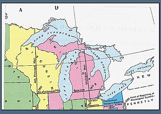
The Public Land Survey System (PLSS) is the surveying method developed and used in the United States to plat, or divide, real property for sale and settling. Also known as the Rectangular Survey System, it was created by the Land Ordinance of 1785 to survey land ceded to the United States by the Treaty of Paris in 1783, following the end of the American Revolution. Beginning with the Seven Ranges in present-day Ohio, the PLSS has been used as the primary survey method in the United States. Following the passage of the Northwest Ordinance in 1787, the Surveyor General of the Northwest Territory platted lands in the Northwest Territory. The Surveyor General was later merged with the United States General Land Office, which later became a part of the U.S. Bureau of Land Management (BLM). Today, the BLM controls the survey, sale, and settling of lands acquired by the United States.

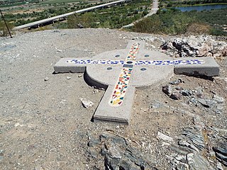
The Willamette Stone was a small stone obelisk originally installed by the Department of Interior in 1885 in the western hills of Portland, Oregon in the United States to mark the intersection and origin of the Willamette meridian and Willamette baseline. It replaced a cedar stake placed by the Surveyor General of the Oregon Territory in 1851; this stake defined the grid system of sections and townships from which all real property in the states of Oregon and Washington has been measured following the Donation Land Claim Act of 1850. The Willamette meridian runs north–south, and the Willamette baseline runs east–west through the marker. The easternmost northeast corner of Washington County is sited on the marker.
The 41st parallel north is a circle of latitude that is 41 degrees north of the Earth's equatorial plane. It crosses Europe, the Mediterranean Sea, Asia, the Pacific Ocean, North America, and the Atlantic Ocean.
The Michigan meridian is the principal meridian used as a reference in the Michigan Survey, the survey of the U.S. state of Michigan in the early 19th century. It is located at 84 degrees, 21 minutes and 53 seconds west longitude at its northern terminus at Sault Ste. Marie, and varies very little from that line down the length of the state.

The San Bernardino meridian, established in 1852, is one of three principal meridians in the state of California. Because of the state's shape, three meridian–baseline sets are required for surveys in all parts of the state. The San Bernardino meridian is used for Southern California, and some townships in Arizona are also referenced to it.

The Humboldt meridian in California, longitude 124° 07' 10" west from Greenwich, intersects the base line on the summit of Mount Pierce at latitude 40° 25' 02" north, and governs the surveys in the northwestern corner of California, lying west of the Coast Range of mountains, and north of township 5 south, of the Humboldt meridian system. This principal meridian was established in 1853.
The Choctaw meridian is a meridian that governs the surveys in most of central Mississippi, USA. It begins on the Choctaw baseline, latitude 31° 54' 40" north, longitude 90° 14' 45" west from Greenwich and runs north to the south boundary of the Chickasaw cession, at latitude 34° 19' 40" north. The surveys of Mississippi by the United States General Land Office begun in 1831 "used the 'Old Choctaw Line' as the 'base meridian' of their efforts to transform the landscape from a landscape of imperial violence to a field of national development."

The second principal meridian, or Paoli Meridian, coincides with 86° 28′ of longitude west from Greenwich, starts from a point two and one half miles west of the confluence of the Little Blue and Ohio rivers, runs north to the northern boundary of Indiana, and, with the base line in latitude 38° 28′ 20″, governs the surveys in Indiana and part of those in Illinois.
The fourth principal meridian, set in 1815, is the principal meridian for land surveys in northwestern Illinois and west-central Illinois, and its 1831 extension is the principal meridian for land surveys in Wisconsin and northeastern Minnesota. It is part of the Public Land Survey System that covers most of the United States.

The Fifth principal meridian, often denoted the "5th Meridian" or "PM 05," is a principal meridian survey line used in the United States for land claims in the Public Land Survey System (PLSS). It was first surveyed in 1815. The meridian, a north-south line, starts from the old mouth of the Arkansas River and runs north. Another survey line related to it is the base line running west from the old mouth of the St. Francis River. These survey lines govern all land surveys in four states and a large portion of the land surveys for two more. Monuments have been erected where the two lines meet at 34°38′44″N91°3′42″W, and the surveyors' skill has been commemorated at the Louisiana Purchase State Park in eastern Arkansas. The Fifth principal meridian is nearly coincident with 91° 3′ 42″ longitude west from the Greenwich meridian.

The Saint Stephens meridian, in longitude 88° 02′ west from Greenwich, begins at the initial point, on the base line, in latitude 31° north, passes through Saint Stephens, Alabama, extends south to Mobile Bay and north to latitude 33° 06′ 20″, and governs the surveys in the southern district of Alabama, and in Pearl River district lying east of the river and south of the Choctaw Baseline, in latitude 31° 52′ 40″ north, in the state of Mississippi.
Saint Helena meridian begins at the initial point of the Washington meridian, in latitude 31° north, and longitude 91° 09′ 15″ west of Greenwich, passing one mile east of Baton Rouge, extends south to the Mississippi River, and governs the surveys in the Greensburg and southeastern districts of Louisiana, east of the Mississippi River.
The Louisiana meridian, in longitude 92° 24′ 15″ west of Greenwich, extends from the Gulf of Mexico to the north boundary of Louisiana, and with the baseline through the initial point conforming to the parallel of 31° north latitude, governs all the surveys in the state west of the Mississippi River.
The Boise meridian is one of the 35 principal meridians of the Public Land Survey System of the United States. Adopted in 1867, its longitude is 116° 23′ 35″ west from Greenwich and its principal baseline is latitude 43° 22′ 21″ north. The meridian and baseline intersect approximately 19 miles (31 km) from Boise, between the Snake River and the Boise River. The Boise meridian governs land surveys in the state of Idaho.
The Black Hills meridian, longitude 104°03′ west from Greenwich, with the baseline in latitude 44° north, is the principal meridian that governs surveys in the state of South Dakota north and west of White River, and west of the Missouri River, the north and west boundaries of the Lower Brule Indian Reservation, and the west boundary of range 79 west, of the Fifth Principal Meridian system. It is named for the Black Hills of South Dakota and Wyoming.
The Montana meridian extends north and south from the initial monument on the summit of a limestone hill, 800 feet high, longitude 111° 39′ 33″ west from Greenwich, and, with the base line on the parallel of 45° 47′ 13″ north latitude, governs the surveys in the state of Montana. The initial point lies near Willow Creek, Montana.
The Gila and Salt River Meridian intersects the initial point on the south side of the Gila River, opposite the mouth of Salt River, at latitude 33° 22′ 37.82733″ north, longitude 112° 18′ 21.99931″ west from Greenwich based on NAD 83, and governs the surveys in the territory of Arizona. The current declination for the initial point is 12° east. It is located on Monument Hill, an easily visible hill just south of the confluence of the Gila and Salt Rivers, in Avondale, Arizona, about 14 miles southwest of downtown Phoenix.
The Navajo meridian, established in 1869, is one of the two principal meridians for Arizona, the other being the Gila and Salt River meridian. Its initial point was stated as latitude 35° 45' north, longitude 108° 32' 45" west from Greenwich, but has been revised as 35°44′56″N108°31′59″W The Navajo meridian and baseline were used to set townships and ranges in a special survey for the original Navajo Reservation, and was set at the eastern boundary of that reservation. The Arizona lands surveyed using the Navajo meridian and baseline were ranges six west to ten west and townships one north to fourteen north, and included Canyon de Chelly National Monument.

The Congress Lands was a group of land tracts in Ohio that made land available for sale to members of the general public through land offices in various cities, and through the United States General Land Office. It consisted of three groups of surveys: