Congress Lands

Last updated
Congress Lands in Ohio Congress Lands in Ohio.png
Congress Lands in Ohio

The Congress Lands was a group of land tracts in Ohio that made land available for sale to members of the general public through land offices in various cities, and through the General Land Office. It consisted of three groups of surveys: [1]

Ohio State of the United States of America

Ohio is a Midwestern state in the Great Lakes region of the United States. Of the fifty states, it is the 34th largest by area, the seventh most populous, and the tenth most densely populated. The state's capital and largest city is Columbus.

General Land Office former agency of the US Department of the Interior

The General Land Office (GLO) was an independent agency of the United States government responsible for public domain lands in the United States. It was created in 1812 to take over functions previously conducted by the United States Department of the Treasury. Starting with the passage of the Land Ordinance of 1785, which created the Public Land Survey System, the Treasury Department had already overseen the survey of the "Northwest Territory", including what is now the state of Ohio.

Contents

Congress Lands East of Scioto River

The Congress Lands East of Scioto River was a land tract in southern Ohio that was established by the Congress late in the 18th century. It is located south of the United States Military District and Refugee Tract, west of the Old Seven Ranges, east of the Virginia Military District and north of the Ohio River, French Grant, and the Ohio Company of Associates.

Congress Lands North of Old Seven Ranges

The Congress Lands North of the Old Seven Ranges was a land tract in northeast Ohio that was established by the Congress early in the 19th century. It is located south of the Connecticut Western Reserve and Firelands, east of the Congress Lands South and East of the First Principal Meridian, north of the United States Military District and Seven Ranges, and west of Pennsylvania.

Congress Lands West of Miami River

The Congress Lands West of Miami River was a land tract in southwest Ohio that was established by the Congress late in the 18th century. It is located south of the Greenville Treaty Line, east of Indiana, and north of the Great Miami River. The original survey in 1798 contained a triangular shaped slice of land, now located in Indiana, that extended to the Greenville line as it ran from Fort Recovery to opposite the mouth of the Kentucky River.

Ohio River Base

The Ohio River Base consisted of the Congress Lands East of Scioto River, and Congress Lands North of Old Seven Ranges. These surveys had vertical rows of six mile square townships called Ranges. These ranges were numbered from Ellicott’s Line , the boundary between Ohio and Pennsylvania, also known as the Eastern Ohio Meridian . The townships within each range were surveyed north and south from the baseline called the “Geographer’s Line” at 40 degrees 38 minutes north, which runs west from the north bank of the Ohio River where it exits Pennsylvania, at a place now called the Beginning Point of the U.S. Public Land Survey. The townships were not numbered from the baseline, but from south to north beginning with the first partial township in each range formed next to the Ohio River. Thus, townships in adjacent ranges rarely had the same number. This system extended the original numbering plan from the Seven Ranges. There being no east ranges or south townships, plats are designated “Township X of Range Y of Ohio River Survey” with no need for north or west designations. Surveys on the Ohio River Base also consist of the Ohio Company and the Seven Ranges. The Seven Ranges were sold in the same manner, and could be considered Congress Lands, but get a special category to itself.

Survey township mostly-square areas used for land descriptions in the U.S.

Survey township, sometimes called Congressional township, as used by the United States Public Land Survey System, refers to a square unit of land, that is nominally six miles (~9.7 km) on a side. Each 36-square-mile (~93 km2) township is divided into 36 one-square-mile (~2.6 km2) sections, that can be further subdivided for sale, and each section covers a nominal 640 acres (2.6 km2). The townships are referenced by a numbering system that locates the township in relation to a principal meridian (north-south) and a base line (east-west). For example, Township 2 North, Range 4 East is the 4th township east of the principal meridian and the 2nd township north of the base line. Township (exterior) lines were originally surveyed and platted by the US General Land Office using contracted private survey crews. Later survey crews subdivided the townships into sections (interior) lines. Virtually all lands covered by this system were sold according to these boundaries. They are marked on the U.S. Geological Survey topographic maps.

Andrew Ellicott American surveyor

Andrew Ellicott was a U.S. surveyor who helped map many of the territories west of the Appalachians, surveyed the boundaries of the District of Columbia, continued and completed Pierre (Peter) Charles L'Enfant's work on the plan for Washington, D.C., and served as a teacher in survey methods for Meriwether Lewis.

Pennsylvania State of the United States of America

Pennsylvania, officially the Commonwealth of Pennsylvania, is a state located in the northeastern and Mid-Atlantic regions of the United States. The Appalachian Mountains run through its middle. The Commonwealth is bordered by Delaware to the southeast, Maryland to the south, West Virginia to the southwest, Ohio to the west, Lake Erie and the Canadian province of Ontario to the northwest, New York to the north, and New Jersey to the east.

Congress Lands West of Miami River

The Congress Lands West of Miami River consists of lands between the Great Miami River and Indiana, and south of the Greenville Treaty Line. Ranges are designated as east of the First Principal Meridian which is at the Ohio-Indiana border. Townships are numbered from south to north, with irregularities caused by the course of the Great Miami River.

Great Miami River river in the United States of America

The Great Miami River is a tributary of the Ohio River, approximately 160 miles (260 km) long, in southwestern Ohio and Indiana in the United States. The Great Miami flows through Dayton, Piqua, Troy, Hamilton, and Sidney.

Indiana State of the United States of America

Indiana is a U.S. state located in the Midwestern and Great Lakes regions of North America. Indiana is the 38th largest by area and the 17th most populous of the 50 United States. Its capital and largest city is Indianapolis. Indiana was admitted to the United States as the 19th U.S. state on December 11, 1816. Indiana borders Lake Michigan to the northwest, Michigan to the north, Ohio to the east, Kentucky to the south and southeast, and Illinois to the west.

Northwest Ohio

Congress Lands in northwest Ohio consist of North and East of the First Principal Meridian and South and East of the First Principal Meridian. These lands are south of a narrow strip next to the Michigan border, west of the Firelands and the Congress Lands North of Old Seven Ranges, North of the Greenville Treaty Line and the Virginia Military District, and east of Indiana. Townships are surveyed north and south from the baseline at 41 degrees north, and are designated “Township X N, Range Y E of First Principal Meridian” or “Township X S, Range Y E of First Principal Meridian”.

Township Subdivision

General Land Office plan for numbering sections of a standard survey township, adopted May 18, 1796 Theoreticaltownshipmap.gif
General Land Office plan for numbering sections of a standard survey township, adopted May 18, 1796

In all five of Ohio’s Congress Lands, townships are divided into 36 one mile square sections. These sections are numbered by the method established May 18, 1796. [2] Section sixteen of each survey township was set aside for support of public schools.

Other Lands

Lands that were not dispersed in the United States Military District [3] [4] or the Refugee Tract [5] [6] were made available for sale through the various Land Offices, and treated the same as Congress Lands.

See also

Notes

  1. Knepper, p. 43-45.
  2. 1  Stat.   464 - Text of Act of May 18, 1796 Library of Congress
  3. Peters, p. 129-144.
  4. 2  Stat.   236 - Text of Act of March 3, 1803 Library of Congress
  5. Peters, p. 284-292.
  6. 3  Stat.   326 - Text of Act of April 29, 1816 Library of Congress

Related Research Articles

Public Land Survey System system of dividing most of the U.S. into squares

The Public Land Survey System (PLSS) is the surveying method developed and used in the United States to plat, or divide, real property for sale and settling. Also known as the Rectangular Survey System, it was created by the Land Ordinance of 1785 to survey land ceded to the United States by the Treaty of Paris in 1783, following the end of the American Revolution. Beginning with the Seven Ranges, in present-day Ohio, the PLSS has been used as the primary survey method in the United States. Following the passage of the Northwest Ordinance, in 1787, the Surveyor General of the Northwest Territory platted lands in the Northwest Territory. The Surveyor General was later merged with the General Land Office, which later became a part of the U.S. Bureau of Land Management (BLM). Today, the BLM controls the survey, sale, and settling of the new lands. Contrary to what some believe, the BLM does not manage the State Plane Coordinate System (SPCS). The SPCS is managed by the National Geodetic Survey (NGS), known as the U.S. Coast and Geodetic Survey (USC&GS) when the system was created.

Land Ordinance of 1785

The Land Ordinance of 1785 was adopted by the United States Congress of the Confederation on May 20, 1785. It set up a standardized system whereby settlers could purchase title to farmland in the undeveloped west. Congress at the time did not have the power to raise revenue by direct taxation, so land sales provided an important revenue stream. The Ordinance set up a survey system that eventually covered over 3/4 of the area of the continental United States.

Ohio Company of Associates

The Ohio Company of Associates, also known as the Ohio Company, was a land company whose members are today credited with becoming the first non-Native American group to settle in the present-day state of Ohio. In 1788 they established Marietta, Ohio as the first permanent settlement of the new United States in the newly organized Northwest Territory.

Ohio Lands

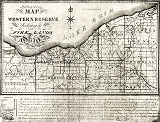
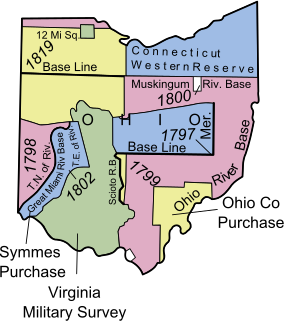
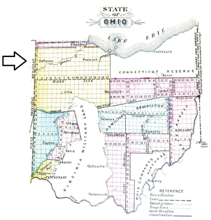
The Ohio Lands were the several grants, tracts, districts and cessions which make up what is now the U.S. state of Ohio. The Ohio Country was one of the first settled parts of the Midwest, and indeed one of the first settled parts of the United States beyond the original 13 colonies. The land that became first the anchor of the Northwest Territory and later Ohio was cobbled together from a variety of sources and owners.

First principal meridian survey line

The first principal meridian is a meridian that began at the junction of the Ohio River and Great Miami River. It extends north on the boundary line between the states of Ohio and Indiana, and roughly approximates to the meridian of longitude 84° 48′ 50″ west from Greenwich. The ranges of the public surveys in the state of Ohio, west of the Scioto River, are numbered from this meridian.

Seven Ranges

The Seven Ranges was a land tract in eastern Ohio that was the first tract to be surveyed in what became the Public Land Survey System. The tract is 42 miles (68 km) across the northern edge, 91 miles (146 km) on the western edge, with the south and east sides along the Ohio River. It consists of all of Monroe, Harrison, Belmont and Jefferson, and portions of Carroll, Columbiana, Tuscarawas, Guernsey, Noble, and Washington County.

Seven Ranges Terminus benchmark

Seven Ranges Terminus is a stone surveying marker near Magnolia, Ohio that marks the completion of the first step in opening the lands northwest of the Ohio River to sale and settlement by Americans. This survey marked the first application of the rectangular plan for subdividing land.

United States Military District

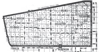
The United States Military District was a land tract in central Ohio that was established by the Congress to compensate veterans of the American Revolutionary War for their service. The tract contains 2,539,110 acres (10,275.4 km2) in Noble, Guernsey, Tuscarawas, Muskingum, Coshocton, Holmes, Licking, Knox, Franklin, Delaware, Morrow, and Marion Counties.

Salt Reservations

The Salt Reservations were a collection of land tracts surrounding salt springs in Ohio and some other states that were donated to the states by the federal government early in the 19th century.

Twelve Mile Square Reservation

The Twelve Mile Square Reservation, also called the Twelve Mile Square Reserve, was a tract of land in Ohio ceded by Indians to the United States of America in the Treaty of Greenville in 1795. This particular area of land immediately surrounding Fort Miami was considered to be of strategic importance by the United States government representatives. It was subsequently surveyed in a manner different from surrounding land, and lots sold, or granted, to settlers.

Two Mile Square Reservation

The Two Mile Square Reservation or Two Mile Square Reserve was a tract of land in Ohio ceded by Native Americans to the United States of America in the Treaty of Greenville in 1795. It was subsequently surveyed in a manner different from surrounding land, and lots sold to settlers.

North and East of First Principal Meridian

North and East of the First Principal Meridian is a survey and land description in the northwest part of the American state called Ohio.

Zanes Tracts

Zane's Tracts were three parcels of land in the Northwest Territory of the United States, later Ohio, that the federal government granted to Ebenezer Zane late in the 18th century, as compensation for establishing a road with ferry service over several rivers.

Indian Land Grants

Indian Land Grants were land tracts granted to various Indians by Treaty or by United States Congressional action in the Nineteenth century in northwestern Ohio.

Israel Ludlow American surveyor

Israel Ludlow was a government surveyor who helped found Cincinnati, Dayton and Hamilton in southwest Ohio.

References

Coordinates: 40°21′29″N80°36′51″W / 40.35806°N 80.61417°W / 40.35806; -80.61417