South and East of the First Principal Meridian

Last updated

South and East of the First Principal Meridian is a land description in the American Midwest.

Contents

Arrow points to tract South & East of First Principal Meridian.png
Arrow points to tract

In 1812, Congress authorized the Surveyor General to survey the northern and western border of Ohio “as soon as the consent of the Indians can be obtained.“ [1] In 1817, the northern portion of the Ohio-Indiana border was surveyed and became known as the First Principal Meridian for lands surveyed in the northwest part of Ohio. The 41st parallel north latitude became the base line. Congress Lands lying east of the meridian and south of the base line were first surveyed in 1819 under the direction of Edward Tiffin, Surveyor General of the United States. The tract included Indian reservations surveyed after the tribes left. This survey used the standard six-mile-square township, but townships were numbered north to south. Surveyed ranges were numbered west to east. Before this, land had been surveyed using several inconsistent and less satisfactory systems

The Surveyor General is an official responsible for government surveying in a specific country or territory. Historically this would often have been a military appointment, but it is now more likely to be a civilian post.

Ohio State of the United States of America

Ohio is a Midwestern state in the Great Lakes region of the United States. Of the fifty states, it is the 34th largest by area, the seventh most populous, and the tenth most densely populated. The state's capital and largest city is Columbus.

Indiana State of the United States of America

Indiana is a U.S. state located in the Midwestern and Great Lakes regions of North America. Indiana is the 38th largest by area and the 17th most populous of the 50 United States. Its capital and largest city is Indianapolis. Indiana was admitted to the United States as the 19th U.S. state on December 11, 1816. Indiana borders Lake Michigan to the northwest, Michigan to the north, Ohio to the east, Kentucky to the south and southeast, and Illinois to the west.

Allen, Auglaize, Crawford, Hancock, Van Wert, and Wyandot counties as well as portions of Hardin, Logan, Marion, Mercer, Morrow, and Putnam counties are included in the survey.

Allen County, Ohio county in Ohio, United States

Allen County is a county in the U.S. state of Ohio. As of the 2010 census, the population was 106,331. The county seat is Lima. The county was created in 1820 and organized in 1831. The county is named for Colonel John Allen, who was killed leading his men at the Battle of Frenchtown, during the War of 1812. It has also been claimed the county was named for Revolutionary War soldier Ethan Allen, but the weight of the evidence in favor of John Allen led the General Assembly to declare in 1976 that the county was named for him.

Auglaize County, Ohio county in Ohio, United States

Auglaize County is a county located in the U.S. state of Ohio. As of the 2010 census, the population was 45,949. Its county seat is Wapakoneta.

Crawford County, Ohio county in Ohio, United States

Crawford County is a county located in the U.S. state of Ohio. As of the 2010 census, the population was 43,784. The approximate population as of 2014 is 42,480, causing a -3.00% change over the past 4 years, according to the United States Census Bureau. Its county seat is Bucyrus. The county was created in 1820 and later organized in 1836. It was named for Colonel William Crawford, a soldier during the American Revolution.

Land Sales

The Act of March 3, 1819 [2] established the Piqua Land District, with a Land Office in that town for sale of lands in this survey within 48 miles of the state of Indiana. For lands in this survey more than 48 miles from Indiana, a land office and land district were established at Delaware. The Piqua office was moved to ”Wapaughkoneta“, then, on March 3, 1835, [3] to Lima, and finally, on March 3, 1843, [4] to a consolidated land district at Upper Sandusky. Sales were also conducted from the nation’s capital at the General Land Office. Local offices were eventually closed. The State of Ohio also eventually sold lands granted to them by the federal government, such as section 16 of each township, and the Turnpike Lands.

Piqua, Ohio City in Ohio, United States

Piqua is a city in Miami County, southwest Ohio, United States, 27 miles north of Dayton. The population was 20,522 at the 2010 census. It is part of the Dayton Metropolitan Statistical Area.

Delaware, Ohio City in Ohio, United States

Delaware is a city in and the county seat of Delaware County, Ohio, United States. Delaware was founded in 1808 and was incorporated in 1816. It is located near the center of Ohio, is about 30 miles (48 km) north of Columbus, and is part of the Columbus, Ohio Metropolitan Area. The population was 34,753 at the 2010 census, while the Columbus-Marion-Chillicothe, OH Combined Statistical Area has 2,002,604 people.

Wapakoneta, Ohio Place in Ohio, United States

Wapakoneta, is a city in and the county seat of Auglaize County, Ohio, United States, about 56 mi north of Dayton and 83 mi south of Toledo. The population was 9,867 at the 2010 census. It is the principal city of and is included in the Wapakoneta, Ohio Micropolitan S A, which is included in the Lima-Van Wert-Wapakoneta, Ohio CSA. The community is served by the Wapakoneta City School District.

See also

Ohio Lands

The Ohio Lands were the several grants, tracts, districts and cessions which make up what is now the U.S. state of Ohio. The Ohio Country was one of the first settled parts of the Midwest, and indeed one of the first settled parts of the United States beyond the original 13 colonies. The land that became first the anchor of the Northwest Territory and later Ohio was cobbled together from a variety of sources and owners.

Historic regions of the United States Wikimedia list article

This is a list of historic regions of the United States that existed at some time during the territorial evolution of the United States and its overseas possessions, from the colonial era to the present day. It includes formally organized territories, proposed and failed states, unrecognized breakaway states, international and interstate purchases, cessions, and land grants, and historical military departments and administrative districts. The last section lists informal regions from American vernacular geography known by popular nicknames and linked by geographical, cultural, or economic similarities, some of which are still in use today.

Related Research Articles

Land Ordinance of 1785

The Land Ordinance of 1785 was adopted by the United States Congress of the Confederation on May 20, 1785. It set up a standardized system whereby settlers could purchase title to farmland in the undeveloped west. Congress at the time did not have the power to raise revenue by direct taxation, so land sales provided an important revenue stream. The Ordinance set up a survey system that eventually covered over 3/4 of the area of the continental United States.

Lucius Lyon American politician

Lucius Lyon was a U.S. statesman from the state of Michigan. He was born in Shelburne, Vermont, where he received a common school education and studied engineering and surveying. He moved to Bronson, Michigan, in 1821 where he became a land surveyor, eventually becoming the Deputy Surveyor General of the Michigan Territory.

College Township

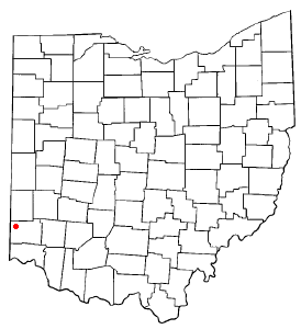
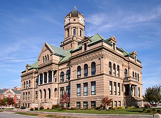
The "College Township" was the full survey township located in the northwest corner of Butler County, Ohio, now corresponding to the civil township of Oxford, designated by the Ohio General Assembly to be the site of the state university now called Miami University. When Congress, on May 5, 1792, authorized the sale to John Cleves Symmes of the land known as the Symmes Purchase, one of the terms was that he would allocate a full township of land to support a university, a promise he never fulfilled. The United States Congress subsequently allowed the State of Ohio to pick a township in the public domain for a college. They chose a township in the first range in the Congress Lands, namely R1E T5.

Michigan meridian

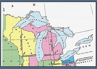
The Michigan meridian is the principal meridian used as a reference in the Michigan Survey, the survey of the U.S. state of Michigan in the early 19th century. It is located at 84 degrees, 21 minutes and 53 seconds west longitude at its northern terminus at Sault Ste. Marie, and varies very little from that line down the length of the state.

Surveyor General of the Northwest Territory former appointed political position in the US

The Surveyor General of the Northwest Territory was a United States government official responsible for surveying land in the Northwest Territory in the United States late in the late eighteenth and early nineteenth century. The position was created in the Land Act of 1796 to survey lands ceded by Indians northwest of the Ohio River and above the mouth of the Kentucky River. This act, and those that followed evolved into the Public Land Survey System.

Military Tract of 1812

On May 6, 1812, an act of Congress was passed 2 Stat. 729 (PDF) which set aside bounty lands as payment to volunteer soldiers for the War against the British. The land was set aside in western territories that became part of the present states of Arkansas, Michigan and Illinois.

Seven Ranges

The Seven Ranges was a land tract in eastern Ohio that was the first tract to be surveyed in what became the Public Land Survey System. The tract is 42 miles (68 km) across the northern edge, 91 miles (146 km) on the western edge, with the south and east sides along the Ohio River. It consists of all of Monroe, Harrison, Belmont and Jefferson, and portions of Carroll, Columbiana, Tuscarawas, Guernsey, Noble, and Washington County.

Congress Lands

The Congress Lands was a group of land tracts in Ohio that made land available for sale to members of the general public through land offices in various cities, and through the General Land Office. It consisted of three groups of surveys:

United States Military District

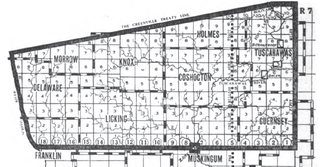
The United States Military District was a land tract in central Ohio that was established by the Congress to compensate veterans of the American Revolutionary War for their service. The tract contains 2,539,110 acres (10,275.4 km2) in Noble, Guernsey, Tuscarawas, Muskingum, Coshocton, Holmes, Licking, Knox, Franklin, Delaware, Morrow, and Marion Counties.

Congress Lands North of Old Seven Ranges

The Congress Lands North of the Old Seven Ranges was a land tract in northeast Ohio that was established by the Congress early in the 19th century. It is located south of the Connecticut Western Reserve and Firelands, east of the Congress Lands South and East of the First Principal Meridian, north of the United States Military District and Seven Ranges, and west of Pennsylvania.

Congress Lands West of Miami River

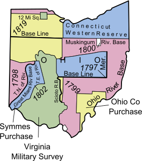
The Congress Lands West of Miami River was a land tract in southwest Ohio that was established by the Congress late in the 18th century. It is located south of the Greenville Treaty Line, east of Indiana, and north of the Great Miami River. The original survey in 1798 contained a triangular shaped slice of land, now located in Indiana, that extended to the Greenville line as it ran from Fort Recovery to opposite the mouth of the Kentucky River.

Congress Lands East of Scioto River

The Congress Lands East of Scioto River was a land tract in southern Ohio that was established by the Congress late in the 18th century. It is located south of the United States Military District and Refugee Tract, west of the Old Seven Ranges, east of the Virginia Military District and north of the Ohio River, French Grant, and the Ohio Company of Associates.

Maumee Road Lands

Maumee Road Lands were a group of land tracts granted by the United States Congress to the state of Ohio in 1823 along the path of a proposed road in the northwest corner of the state.

Turnpike Lands were a group of land tracts granted by the United States Congress to the state of Ohio in 1827 along the path of a proposed road in the northwest corner of the state.

Salt Reservations

The Salt Reservations were a collection of land tracts surrounding salt springs in Ohio and some other states that were donated to the states by the federal government early in the 19th century.

Twelve Mile Square Reservation

The Twelve Mile Square Reservation, also called the Twelve Mile Square Reserve, was a tract of land in Ohio ceded by Indians to the United States of America in the Treaty of Greenville in 1795. This particular area of land immediately surrounding Fort Miami was considered to be of strategic importance by the United States government representatives. It was subsequently surveyed in a manner different from surrounding land, and lots sold, or granted, to settlers.

Two Mile Square Reservation

The Two Mile Square Reservation or Two Mile Square Reserve was a tract of land in Ohio ceded by Native Americans to the United States of America in the Treaty of Greenville in 1795. It was subsequently surveyed in a manner different from surrounding land, and lots sold to settlers.

North and East of First Principal Meridian

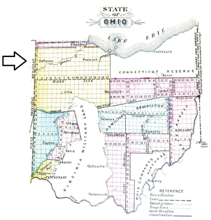
North and East of the First Principal Meridian is a survey and land description in the northwest part of the American state called Ohio.

Indian Land Grants

Indian Land Grants were land tracts granted to various Indians by Treaty or by United States Congressional action in the Nineteenth century in northwestern Ohio.

References

  1. 2  Stat.   741 - Text of Act of May 20, 1812 Library of Congress
  2. 3  Stat.   521 - Text of Act of March 3, 1819 Library of Congress
  3. 4  Stat.   774 - Text of Act of March 3, 1835 Library of Congress
  4. 5  Stat.   624 - Text of Act of March 3, 1843 Library of Congress

Coordinates: 40°54′N84°0′W / 40.900°N 84.000°W / 40.900; -84.000

Geographic coordinate system Coordinate system

A geographic coordinate system is a coordinate system that enables every location on Earth to be specified by a set of numbers, letters or symbols. The coordinates are often chosen such that one of the numbers represents a vertical position and two or three of the numbers represent a horizontal position; alternatively, a geographic position may be expressed in a combined three-dimensional Cartesian vector. A common choice of coordinates is latitude, longitude and elevation. To specify a location on a plane requires a map projection.