Ohio Company of Associates

Last updated
Map of Ohio showing the boundaries of the Ohio Company Purchase on the lower right. Ohio Lands.svg
Map of Ohio showing the boundaries of the Ohio Company Purchase on the lower right.
Rufus Putnam PUTNAM exb.jpg
Rufus Putnam
Pioneer wagon ForTheOhio.jpg
Pioneer wagon

The Ohio Company of Associates, also known as the Ohio Company, was a land company whose members are today credited with becoming the first non-Native American group to permanently settle west of the Allegheny mountains. In 1788 they established Marietta, Ohio, as the first permanent settlement of the new United States in the newly organized Northwest Territory. [1]

Contents

Creation of the company

The company was formed between March 1 and March 3, 1786, by Rufus Putnam, Benjamin Tupper, Samuel Holden Parsons and Manasseh Cutler in Boston, Massachusetts. They had met at The Bunch-of-Grapes tavern, located on King Street, to discuss the settlement of the territory around the Ohio River. [2] On March 8, 1787, Parsons, Putnam, and Cutler were chosen as directors, and Winthrop Sargent was elected secretary. [3] On August 30, 1787, James Mitchell Varnum was elected as a director, and Richard Platt as treasurer. [4] Later directors included Griffin Greene upon the death of Varnum, [5] and Robert Oliver upon the death of Parsons. [6]

Negotiations with the government

Cutler was sent to New York to negotiate with the Congress of the Confederation to help the company secure a claim on a portion of the land. While there, Cutler aligned himself with William Duer, secretary of the U.S. Treasury Board. Duer and his associates formed a group of New York speculators who were determined to see settlement of the area west of the Appalachians. [7] At this time, Congress desperately needed revenue. The prospect of sales of land helped settle controversy and secure the incorporation in the Northwest Ordinance of the paragraphs that prohibited slavery, provided for land for public education and for the support of the ministry. [8]

The Ohio Company's purchase was enabled first by the passage on July 13, 1787, of the "Ordinance for the Government of the Territory of the United States Northwest of the River Ohio," commonly known as the Northwest Ordinance, and second, by the Act of October 23, 1787, which authorized Congress to make contracts of public lands for not less than one million acres. On October 27, 1787, the Treasury Board under Secretary William Duer finalized the Ohio Company's purchase. Their first contract was for the Ohio Company to purchase 1,500,000 acres (6,000 km²) of land at the confluence of the Ohio and Muskingum rivers, from a point near the site of present-day Marietta, to a point nearly opposite present-day Huntington, West Virginia, for a payment of $1 million in government securities, then worth about 12¢ specie to the dollar. [2] The contract also provided that one section of land in every township be devoted to the maintenance of public schools, another section be set apart for religious uses, and two entire townships be reserved for a university.

The proposed purchase by the Scioto Company is shown in red. The proposed purchase of 1,500,000 acres (6,100 km) by the Ohio Company is in blue. The final dimensions of the Ohio Company is in green, including the First Purchase, Second Purchase, and Donation Tract. Ohio-scioto lands.png
The proposed purchase by the Scioto Company is shown in red. The proposed purchase of 1,500,000 acres (6,100 km) by the Ohio Company is in blue. The final dimensions of the Ohio Company is in green, including the First Purchase, Second Purchase, and Donation Tract.

The second contract was an option to buy all the land between the Ohio and the Scioto rivers and the western boundary line of the Ohio Company's tract, extending north of the tenth survey township from the Ohio, this tract being preempted by Manasseh Cutler and Winthrop Sargent for themselves and others for the Scioto Company. Cutler's original intent was to buy only about 1,500,000 acres (6,000 km²) for the Ohio Company, but on the July 27, Congress authorized a grant of about 5,000,000 acres (20,000 km²) of land for $3,500,000; a reduction of one-third was allowed for bad tracts, and it was also provided that the lands could be paid for in United States securities. On the same day, Cutler and Sargent for themselves and associates transferred to William Duer, then Secretary of the Treasury Board, and his associates one equal moiety of the Scioto tract of land mentioned in the second contract. Both parties were to be equally interested in the sale of the land, and were to share equally any profit or loss. But, the Scioto Company interest was speculative, and their contract lapsed before they purchased any land. In contrast, the Ohio Company had a genuine plan of settlement.

The company made its first installment of $500,000, but was unable to raise the second $500,000. It settled for a purchase of 750,000 acres (3,000 km2), plus the two townships for College Lands and the reserved School Lands and Ministerial Lands sections in each township, for a total area of 913,833 acres (3,698.15 km2), called the First Purchase. [9] The lands were privately surveyed, but on the same plan of townships, ranges, and sections as the adjacent Seven Ranges under the procedure of the Land Ordinance of 1785. [10] [11]

Settlement at Marietta, Ohio

In 1788, General Rufus Putnam laid out the plans for Marietta, the first permanent settlement in the present state of Ohio. [12] The Ohio Company sent pioneers from New England to the Northwest Territory. Their first purchase was in Washington, Meigs, Gallia, Lawrence and Athens counties.

Difficulties with Native Americans during the Northwest Indian War, including the Big Bottom Massacre, led Congress in 1792 to donate 100,000 acres (400 km2) on the north edge of the first purchase as a buffer against incursion. The Donation Tract incorporated much of present-day Washington and Morgan counties. Many associates of the company held army bounty warrants, which they could exchange for federal land, totaling 142,900 acres (578 km2).

Later in 1792, the Ohio Company purchased another 214,285 acres (867.18 km2) in Morgan, Hocking, Vinton and Athens counties, using these bounties, with the 1/3 discount for bad lands, as in the first purchase. [13] The Second Purchase had no sections set aside for schools or ministry. The Second Purchase is also known as the Purchase on the Muskingum. [11]

In 1796, the Ohio Company divided its shares and ceased to be a genuine land company.

TRACTAREA
(acres)
AREA
(Hectares)
First
Purchase
913833369816
Second
Purchase
21428586718
Donation
Tract
10000040469
Total1228118497002

See also

Notes

  1. Hubbard, Robert Ernest. General Rufus Putnam: George Washington's Chief Military Engineer and the "Father of Ohio," pp. 2-4, 80, McFarland & Company, Inc., Jefferson, North Carolina, 2020. ISBN   978-1-4766-7862-7.
  2. 1 2 Hubbard, Robert Ernest. General Rufus Putnam: George Washington's Chief Military Engineer and the "Father of Ohio," p. 104, McFarland & Company, Inc., Jefferson, North Carolina, 2020. ISBN   978-1-4766-7862-7.
  3. Hildreth, Pioneer History, 199.
  4. Hildreth, Pioneer History, 200-01.
  5. Hildreth, Pioneer History, 249.
  6. Hildreth, Pioneer History, 259.
  7. A bronze historical plaque on the wall of Federal Hall National Memorial in New York commemorates the Ohio Company, with a map of Ohio.
  8. Hubbard, Robert Ernest. General Rufus Putnam: George Washington's Chief Military Engineer and the "Father of Ohio," pp. 2-4, McFarland & Company, Inc., Jefferson, North Carolina, 2020. ISBN   978-1-4766-7862-7.
  9. Knepper, George W (2002). The Official Ohio Lands Book (PDF). The Auditor of the State of Ohio. pp. 27–30.
  10. Text of Ordinance of May 20, 1785 Library of Congress
  11. 1 2 Peters, William E (1918). Ohio Lands and Their Subdivision. W.E. Peters. pp. 237–258.
  12. Hubbard, Robert Ernest. General Rufus Putnam: George Washington's Chief Military Engineer and the "Father of Ohio," pp. 2-4, 80, 107, McFarland & Company, Inc., Jefferson, North Carolina, 2020. ISBN   978-1-4766-7862-7.
  13. 6  Stat.   8 - Text of Act of April 21, 1792 Library of Congress

Related Research Articles

<span class="mw-page-title-main">Marietta, Ohio</span> City in Ohio, United States

Marietta is a city in, and the county seat of, Washington County, Ohio, United States. It is located in southeastern Ohio at the confluence of the Muskingum and Ohio Rivers, 11 miles (18 km) northeast of Parkersburg, West Virginia. As of the 2020 census, Marietta has a population of 13,385 people and is the principal city of the Marietta Micropolitan Statistical Area, which includes all of Washington County, and is the second-largest city in the Parkersburg–Marietta–Vienna, WV–OH Combined Statistical Area.

<span class="mw-page-title-main">Northwest Ordinance</span> American organic legislation creating Northwest Territory

The Northwest Ordinance, enacted July 13, 1787, was an organic act of the Congress of the Confederation of the United States. It created the Northwest Territory, the new nation's first organized incorporated territory, from lands beyond the Appalachian Mountains, between British North America and the Great Lakes to the north and the Ohio River to the south. The upper Mississippi River formed the territory's western boundary. Pennsylvania was the eastern boundary.

<span class="mw-page-title-main">Northwest Territory</span> United States territory (1787–1803)

The Northwest Territory, also known as the Old Northwest and formally known as the Territory Northwest of the River Ohio, was formed from unorganized western territory of the United States after the American Revolutionary War. Established in 1787 by the Congress of the Confederation through the Northwest Ordinance, it was the nation's first post-colonial organized incorporated territory.

<span class="mw-page-title-main">Scioto Company</span>

The Scioto Company was led by American colonel William Duer, a speculator who worked with a British colleague and several French men to register and organize the company in Paris, France. Ostensibly working with the Ohio Company to purchase land in the Northwest Territory, agents of this institution sold worthless deeds to French people intending to emigrate to the United States. Many were refugees from the excesses of the French Revolution, and the émigrés were made up of minor aristocrats, merchants, artisans and craftsmen. The Scioto Company did not own the land it was selling.

<span class="mw-page-title-main">Rufus Putnam</span> American general and pioneer (1738–1824)

Brigadier-General 
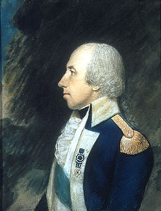
Rufus Putnam was an American military officer who fought during the French and Indian War and the American Revolutionary War. As an organizer of the Ohio Company of Associates, he was instrumental in the initial colonization of the Northwest Territory in present-day Ohio following the war. He was known as "Father of the Northwest Territory".

<span class="mw-page-title-main">Manasseh Cutler</span> American politician (1742–1823)

Manasseh Cutler was an American clergyman involved in the American Revolutionary War. He was influential in the passage of the Northwest Ordinance of 1787 and wrote the section prohibiting slavery in the Northwest Territory. Cutler was also a member of the United States House of Representatives. Cutler is "rightly entitled to be called 'The Father of Ohio University.'"

<span class="mw-page-title-main">Big Bottom massacre</span> 1791 mass killing of settlers by Native Americans near present-day Stockport, Ohio, USA

The Big Bottom massacre occurred on January 2, 1791, near present-day Stockport now in Morgan County, Ohio, United States. It is considered part of the Northwest Indian Wars, in which native Americans in the Ohio Country confronted American settlers, regular soldiers and militia, seeking to expel them from their territory.

<span class="mw-page-title-main">Mound Cemetery (Marietta, Ohio)</span> Historic site in Washington County, Ohio

Mound Cemetery in Marietta, Ohio, is a historic cemetery developed around the base of a prehistoric Adena burial mound known as the Great Mound or Conus. The city founders preserved the Great Mound from destruction by establishing the city cemetery around it in 1801.

<span class="mw-page-title-main">Benjamin Tupper</span> American soldier and pioneer (1738–1792)

Benjamin Tupper was a soldier in the French and Indian War, and an officer of the Continental Army during the American Revolutionary War, achieving the rank of brevet brigadier general. Subsequently, he served as a Massachusetts legislator, and he assisted Gen. William Shepard in stopping Shays' Rebellion. Benjamin Tupper was a co-founder of the Ohio Company of Associates, and was a pioneer to the Ohio Country, involved in establishing Marietta, Ohio as the first permanent settlement in the Northwest Territory.

<span class="mw-page-title-main">Rufus Putnam House</span> Historic house in Ohio, United States

The Rufus Putnam House, also known as Campus Martius or Campus Martius Museum State Memorial, is a historic building in Marietta, Ohio. It was built as part of the Campus Martius fortification by General Rufus Putnam, during the early settlement of Ohio by the Ohio Company of Associates.

<span class="mw-page-title-main">Campus Martius (Ohio)</span>

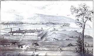
Campus Martius was a defensive fortification at the Marietta, Ohio settlement, and was home to Rufus Putnam, Benjamin Tupper, Arthur St. Clair, and other pioneers from the Ohio Company of Associates during the Northwest Indian War. Major Anselm Tupper was commander of the Campus Martius during the war. Construction began in 1788 and was fully completed in 1791. The Campus Martius was located on the east side of the Muskingum River, and upriver from its confluence with the Ohio River. A firsthand description of the fort is provided in Hildreth's Pioneer History,

Campus Martius is the handsomest pile of buildings on this side of the Alleghany mountains, and in a few days will be the strongest fortification in the territory of the United States. It stands on the margin of the elevated plain on which are the remains of the ancient works [mounds], mentioned in my letter of May last, thirty feet above the high bank of the Muskingum, twenty-nine perches distant from the river, and two hundred and seventy-six from the Ohio. It consists of a regular square, having a block house at each angle, eighteen feet square on the ground, and two stories high; the upper story on the outside or face, jutting over the lower one, eighteen inches. These block houses serve as bastions to a regular fortification of four sides. The curtains are composed of dwelling houses two stories high, eighteen feet wide, and of different lengths.

<span class="mw-page-title-main">Seven Ranges</span>

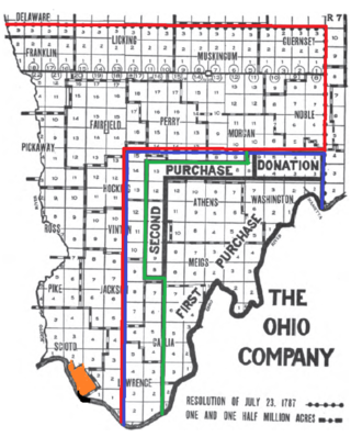
The Seven Ranges was a land tract in eastern Ohio that was the first tract to be surveyed in what became the Public Land Survey System. The tract is 42 miles (68 km) across the northern edge, 91 miles (146 km) on the western edge, with the south and east sides along the Ohio River. It consists of all of Monroe, Harrison, Belmont and Jefferson, and portions of Carroll, Columbiana, Tuscarawas, Guernsey, Noble, and Washington County.

<span class="mw-page-title-main">Donation Tract</span>

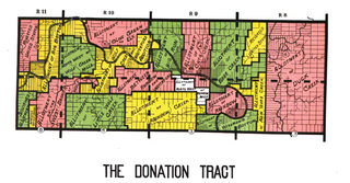
The Donation Tract was a land tract in southern Ohio that was established by the Congress late in the 18th century to buffer Ohio Company lands against local indigenous people. Congress gave 100-acre (0.40 km2) lots to men who settled on the land. This marked the first time that federal land was given without charge to specified settlers, predating the more famous Homestead Act of 1862 by seventy years.

<span class="mw-page-title-main">Congress Lands East of Scioto River</span>

The Congress Lands East of Scioto River was a land tract in southern Ohio that was established by the Congress late in the 18th century. It is located south of the United States Military District and Refugee Tract, west of the Old Seven Ranges, east of the Virginia Military District and north of the Ohio River, French Grant, and the Ohio Company of Associates.

<span class="mw-page-title-main">Ebenezer Sproat</span>

Ebenezer Sproat, surname also spelled Sprout, was an officer of the Continental Army during the American Revolutionary War, a pioneer to the Ohio Country, and one of the founders of Marietta, Ohio, the first permanent American settlement in the Northwest Territory. He served throughout the entire American war of independence, from April 1775 through November 1783, achieving the rank of colonel. After the war, he was a pioneer and surveyor in the Northwest Territory, and became a leader of the militia at Marietta during the Northwest Indian War. He was the first sheriff in the Northwest Territory and Ohio, serving fourteen years as sheriff of Washington County, the oldest county in Ohio.

<span class="mw-page-title-main">Purchase on the Muskingum</span>

The Purchase on the Muskingum also called Ohio Company's Second Purchase, was a tract of land in the Northwest Territory, later Ohio, that the Ohio Company of Associates purchased from the United States federal government in 1792.

<span class="mw-page-title-main">College Lands</span>

The College Lands were a tract of land in the Northwest Territory, later Ohio, that the Congress donated for the support of a university. Ohio University became the first college northwest of the Ohio River as a beneficiary of this tract.
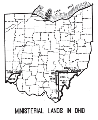
<span class="mw-page-title-main">Ephraim Cutler</span> American politician

Ephraim Cutler was an early Northwest Territory and Ohio political leader and jurist.

Robert Richard Oliver was a lieutenant colonel in the American Revolutionary War and a representative and president of the council of the Northwest Territory's first general assembly.

References

Attribution