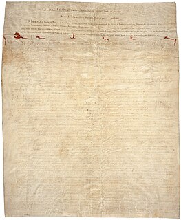
The Treaty of Greenville, formally titled Treaty with the Wyandots, etc., was a 1795 treaty between the United States and indigenous nations of the Northwest Territory, including the Wyandot and Delaware peoples, that redefined the boundary between indigenous peoples' lands and territory for European American community settlement.

The Maumee River is a river running in the United States Midwest from northeastern Indiana into northwestern Ohio and Lake Erie. It is formed at the confluence of the St. Joseph and St. Marys rivers, where Fort Wayne, Indiana, has developed, and meanders northeastwardly for 137 miles (220 km) through an agricultural region of glacial moraines before flowing into the Maumee Bay of Lake Erie. The city of Toledo is located at the mouth of the Maumee. The Maumee was designated an Ohio State Scenic River on July 18, 1974. The Maumee watershed is Ohio’s breadbasket; it is two-thirds farmland, mostly corn and soybeans. It is the largest watershed of any of the rivers feeding the Great Lakes, and supplies five percent of Lake Erie’s water.

The Treaty of St. Mary's may refer to one of six treaties concluded in fall of 1818 between the United States and Natives of central Indiana regarding purchase of Native land. The treaties were

The Treaty of Fort Meigs, also called the Treaty of the Maumee Rapids, formally titled, "Treaty with the Wyandots, etc., 1817", was the most significant Indian treaty in Ohio since the Treaty of Greenville in 1795, and resulted in cession by the Indians of nearly all remaining Indian lands in northwestern Ohio. It was the last but one and largest wholesale purchase of Indian land in Ohio.
The Treaty of Fort Industry was a successor treaty to the Treaty of Greenville, which moved the eastern boundary of Indian lands in northern Ohio from the Tuscarawas River and Cuyahoga River westward to a line 120 miles west of the Pennsylvania boundary, which coincided with the western boundary of the Firelands of the Connecticut Western Reserve. In return, the United States agreed "every year forever hereafter, at Detroit, or some other convenient place" to pay $825 for the ceded lands south of the 41st degree of north latitude, and an additional $175 for the Firelands, which lie north of 41 degrees north, which the President would secure from the Connecticut Land Company, for a total of annuity $1000.00, to be "divided between said nations, from time to time, in such proportions as said nations, with the approbation of the President, shall agree."
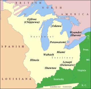
The Northwestern Confederacy, or Northwestern Indian Confederacy, was a loose confederacy of Native Americans in the Great Lakes region of the United States created after the American Revolutionary War. Formally, the confederacy referred to itself as the United Indian Nations, at their Confederate Council. It was known infrequently as the Miami Confederacy since many contemporaneous federal officials overestimated the influence and numerical strength of the Miami tribes based on the size of their principal city, Kekionga.

The Treaty of Fort Wayne was a treaty between the United States and several groups of Native Americans. The treaty was signed on June 7, 1803 and proclaimed December 26, 1803. It more precisely defined the boundaries of the Vincennes tract ceded to the United States by the Treaty of Greenville, 1795.
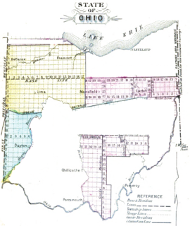
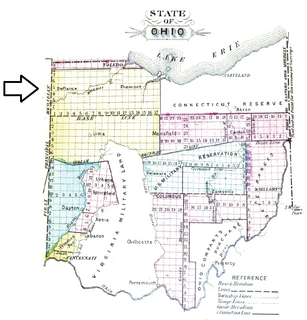
The Congress Lands was a group of land tracts in Ohio that made land available for sale to members of the general public through land offices in various cities, and through the General Land Office. It consisted of three groups of surveys:
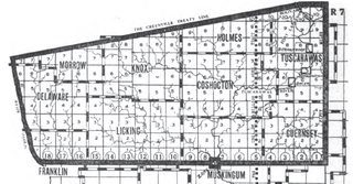
The United States Military District was a land tract in central Ohio that was established by the Congress to compensate veterans of the American Revolutionary War for their service. The tract contains 2,539,110 acres (10,275.4 km2) in Noble, Guernsey, Tuscarawas, Muskingum, Coshocton, Holmes, Licking, Knox, Franklin, Delaware, Morrow, and Marion Counties.

The Congress Lands North of the Old Seven Ranges was a land tract in northeast Ohio that was established by the Congress early in the 19th century. It is located south of the Connecticut Western Reserve and Firelands, east of the Congress Lands South and East of the First Principal Meridian, north of the United States Military District and Seven Ranges, and west of Pennsylvania.
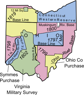
The Congress Lands West of Miami River was a land tract in southwest Ohio that was established by the Congress late in the 18th century. It is located south of the Greenville Treaty Line, east of Indiana, and north of the Great Miami River. The original survey in 1798 contained a triangular shaped slice of land, now located in Indiana, that extended to the Greenville line as it ran from Fort Recovery to opposite the mouth of the Kentucky River.

The Treaty of Brownstown was between the United States and the Council of Three Fires, Wyandott, and Shawanoese Indian Nations. It was concluded November 25, 1808 at Brownstown in Michigan Territory, and provided cession of a strip of Indian land for a road to connect two disconnected areas of land previously ceded by Indians in Michigan and Ohio.
Maumee Road Lands were a group of land tracts granted by the United States Congress to the state of Ohio in 1823 along the path of a proposed road in the northwest corner of the state.
The Twelve Mile Square Reservation, also called the Twelve Mile Square Reserve, was a tract of land in Ohio ceded by Indians to the United States of America in the Treaty of Greenville in 1795. This particular area of land immediately surrounding Fort Miami was considered to be of strategic importance by the United States government representatives. It was subsequently surveyed in a manner different from surrounding land, and lots sold, or granted, to settlers.
The Two Mile Square Reservation or Two Mile Square Reserve was a tract of land in Ohio ceded by Native Americans to the United States of America in the Treaty of Greenville in 1795. It was subsequently surveyed in a manner different from surrounding land, and lots sold to settlers.
North and East of the First Principal Meridian is a survey and land description in the northwest part of the U.S. state of Ohio.
Canal Lands were tracts of land donated by the federal government to several Great Lakes states in the 19th century to encourage internal improvements and aid in funding the construction of Canals. These states sold the land tracts to private parties to raise funds for canal construction.
Indian Land Grants were land tracts granted to various Indians by Treaty or by United States Congressional action in the Nineteenth century in northwestern Ohio.
Indian removals in Ohio started in the late eighteenth century after the American victory in the Revolutionary War and the consequent opening of the Northwestern United States to European-American settlement. Native American tribes residing in the region banded together to resist settlement, resulting in the disastrous Northwest Indian War where the Native tribes ceded large swathes of territory to the American government. After the American victory in the war, several Indian reservations were established to forcibly relocate landless tribes to. The process of obtaining full American sovereignty over Indian territories in Ohio was complete around 1818, but continued in Indiana until 1840.

