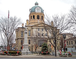
Tuscarawas County is a county located in the northeastern part of the U.S. state of Ohio. As of the 2020 census, the population was 93,263. Its county seat is New Philadelphia. Its name is a Delaware Indian word variously translated as "old town" or "open mouth". Tuscarawas County comprises the New Philadelphia–Dover, OH Micropolitan Statistical Area, which is also included in the Cleveland–Akron–Canton, OH Combined Statistical Area.

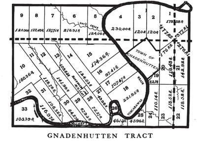
Gnadenhutten is a village located on the Tuscarawas River in Tuscarawas County, Ohio, United States. The population was 1,240 at the 2020 census. It is Ohio's oldest existing settlement, being founded by Moravian Christians in 1772 and was the site of the Gnadenhutten massacre during the American Revolutionary War. It is part of the New Philadelphia–Dover micropolitan area.

The Land Ordinance of 1785 was adopted by the United States Congress of the Confederation on May 20, 1785. It set up a standardized system whereby settlers could purchase title to farmland in the undeveloped west. Congress at the time did not have the power to raise revenue by direct taxation, so land sales provided an important revenue stream. The Ordinance set up a survey system that eventually covered over three-quarters of the area of the continental United States.

The Ohio Lands were the several grants, tracts, districts and cessions which make up what is now the U.S. state of Ohio. The Ohio Country was one of the first settled parts of the Midwest, and indeed one of the first settled parts of the United States beyond the original Thirteen Colonies. The land that became first the anchor of the Northwest Territory and later Ohio was cobbled together from a variety of sources and owners.

Moravian 47 is an Indian reserve located in Chatham-Kent, Ontario, with an area of 13 square kilometres (5.0 sq mi). It is occupied by the Delaware Nation at Moraviantown First Nation, a part of the Christian Munsee branch of the Lenape, and is commonly known as Moravian of the Thames reserve. The resident registered population is 457, with another 587 band members living off the reserve.

The Gnadenhutten massacre, also known as the Moravian massacre, was the killing of 96 pacifist Moravian Christian Indians by U.S. militiamen from Pennsylvania, under the command of David Williamson, on March 8, 1782, at the Moravian missionary village of Gnadenhutten, Ohio Country, during the American Revolutionary War.

The Christian Munsee are a group of Lenape, an Indigenous people in the United States, that primarily speak Munsee and have converted to Christianity, following the teachings of Moravian missionaries. The Christian Munsee are also known as the Moravian Munsee or the Moravian Indians, the Moravian Christian Indians or, in context, simply the Christian Indians. As the Moravian Church transferred some of their missions to other Christian denominations, such as the Methodists, Christian Munsee today belong to the Moravian Church, Methodist Church, United Church of Canada, among other Christian denominations.

The Big Bottom massacre occurred on January 2, 1791, near present-day Stockport now in Morgan County, Ohio, United States. It is considered part of the Northwest Indian Wars, in which native Americans in the Ohio Country confronted American settlers, regular soldiers and militia, seeking to expel them from their territory.
The Refugee Tract is an area of land in Ohio, United States granted to people from British Canada who left home prior to July 4, 1776, stayed in the US until November 25, 1783 continuously, and aided the revolutionary cause.
David Williamson (1752–1814) was a mass murderer and colonel in the Pennsylvania Militia during the American Revolutionary War. He was born near Carlisle, Pennsylvania, and led American militiamen in the Gnadenhutten massacre of the Moravian Christian Indian Martyrs, though he failed in his plan to massacre the Christian Indians in Schoenbrunn. He led Pennsylvanian soldiers in the massacre of peaceful Delaware Indians in Killbuck Island and was second in command in the Crawford expedition. David Williamson allowed his men to rape women and children in the cold snow while simultaneously killing them.

The Seven Ranges was a land tract in eastern Ohio that was the first tract to be surveyed in what became the Public Land Survey System. The tract is 42 miles (68 km) across the northern edge, 91 miles (146 km) on the western edge, with the south and east sides along the Ohio River. It consists of all of Monroe, Harrison, Belmont and Jefferson, and portions of Carroll, Columbiana, Tuscarawas, Guernsey, Noble, and Washington County.
Dohrman Tract or Dohrman’s Grant was a land tract in eastern Ohio granted by Congress to Arnold Henry Dohrman (1749–1813), who helped the American cause in the Revolutionary War.
Seven Ranges Terminus is a stone surveying marker near Magnolia, Ohio that marks the completion of the first step in opening the lands northwest of the Ohio River to sale and settlement by Americans. This survey marked the first application of the rectangular plan for subdividing land.
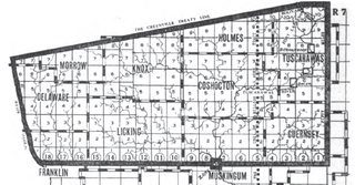
The United States Military District was a land tract in central Ohio that was established by the Congress to compensate veterans of the American Revolutionary War for their service. The tract contains 2,539,110 acres (10,275.4 km2) in Noble, Guernsey, Tuscarawas, Muskingum, Coshocton, Holmes, Licking, Knox, Franklin, Delaware, Morrow, and Marion counties.
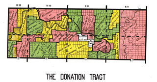
The Donation Tract was a land tract in southern Ohio that was established by the Congress late in the 18th century to buffer Ohio Company lands against local indigenous people. Congress gave 100-acre (0.40 km2) lots to men who settled on the land. This marked the first time that federal land was given without charge to specified settlers, predating the more famous Homestead Act of 1862 by seventy years.

The Congress Lands North of the Old Seven Ranges was a land tract in northeast Ohio that was established by the Congress early in the 19th century. It is located south of the Connecticut Western Reserve and Firelands, east of the Congress Lands South and East of the First Principal Meridian, north of the United States Military District and Seven Ranges, and west of Pennsylvania.
The Twelve Mile Square Reservation, also called the Twelve Mile Square Reserve, was a tract of land in Ohio ceded by Indians to the United States of America in the Treaty of Greenville in 1795. This particular area of land immediately surrounding Fort Miami was considered to be of strategic importance by the United States government representatives. It was subsequently surveyed in a manner different from surrounding land, and lots sold, or granted, to settlers.

Zane's Tracts were three parcels of land in the Northwest Territory of the United States, later Ohio, that the federal government granted to Ebenezer Zane late in the 18th century, as compensation for establishing a road with ferry service over several rivers.
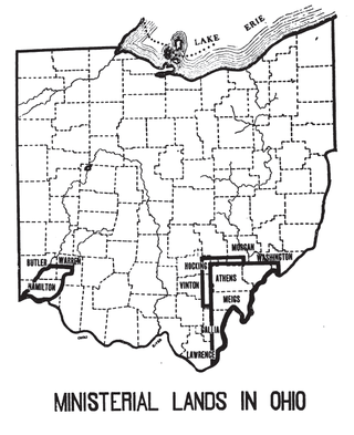
The Ministerial Lands were tracts of land in the Northwest Territory, later Ohio, that the Congress donated for the support of clergy.

Brodhead's Coshocton expedition was a military expedition carried out by Patriot forces against the Lenape near Coshocton, Ohio in April 1781 during the American Revolutionary War. Led by Daniel Brodhead, the Patriots engaged and defeated several Lenape warriors, massacring 16 captives before burning Coshocton and the then-abandoned settlement of Lichtenau to the ground.