Indian removals in Ohio

Last updated

Indian removals in Ohio started in the late eighteenth century after the American victory in the Revolutionary War and the consequent opening of the Northwestern United States to European-American settlement. Native American tribes residing in the region banded together to resist settlement, resulting in the disastrous Northwest Indian War where the Native tribes ceded large swathes of territory to the American government. After the American victory in the war, several Indian reservations were established to forcibly relocate landless tribes to. The process of obtaining full American sovereignty over Indian territories in Ohio was complete around 1818, but continued in Indiana until 1840.

Contents

Background

The Indians of Ohio

Before the American Revolutionary War, the Ohio Territory was populated by tribes of Shawnee in the southwest, Miami in the far west, Wyandot in the northeast, the Senecas in the far northeast, and the Ottawas in the north. [1]

Boundary lines

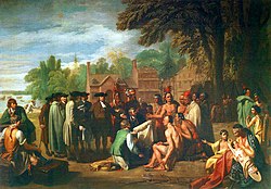
The Royal Proclamation of 1763 reserved what was then Ohio Country and lands beyond west of the Appalachians for Indians, and settlement by European colonists was forbidden. [2] The Treaty of Fort Stanwix in 1768 defined the Ohio River as the boundary between Indian lands and the settler's lands west of the Appalachians. The Treaty of Fort McIntosh in 1785 circumscribed an area of central northern and northwestern Ohio Country as Indian land, essentially creating the first Indian reservation west of the Appalachians. The boundaries of that treaty followed natural landmarks and colonial forts, and became a blueprint for later treaties. Neither Indians nor settlers observed the boundaries of the treaty, resulting in the Northwest Indian War. The Treaty of Fort Harmar in 1789 which essentially reiterated the terms of earlier treaties, was a last attempt to placate the parties. Major United States army campaigns to assert sovereignty over the frontier ensued, culminating in the decisive American victory at Battle of Fallen Timbers in 1794. [1]

The beginning

The United States dictated terms of the peace following the War, circumscribing a boundary line around state territories of Connecticut Western Reserve and Virginia Military District, along with the Symmes and Ohio Company land purchases to include most of southern and eastern Ohio in an area reserved to settlers. [1] The Treaty of Greenville 1795 superseded and nullified all older treaties that conflicted with the new one. The treaty acquired about 2/3 of the future state of Ohio, leaving only the northwestern portion of Ohio Country for the Indians. Northwestern Indian lands were subsequently reduced by the Treaty of Fort Industry 1805 which moved the eastern boundary of Indian lands west to coincide with the western boundary of the Firelands, part of the Connecticut Western Reserve in northeastern Ohio. The process continued with:

Completion and continuance

In fall of 1818, six treaties were part of the Treaty of St. Mary's (1818), including Treaty with the Miami, that ceded the final piece of Ohio between the Greenville Treaty Line and St. Mary's River, completing the acquisition of Ohio for the United States. At the same time, the process of acquisition of lands and removal of Indians continued in Indiana with the other 5 treaties, acquiring nearly 1/3 of the land of Indiana thereby.[ citation needed ]

Removals

Treaties after 1818 involved purchase or cession of reservations, and Indians were removed to out of state Indian Territory.[ citation needed ]

The last Indians in Ohio were removed in 1843 via Treaty with the Wyandots (1842) by which the reservation at Upper Sandusky was ceded to the United States, and the Wyandots relocated to Oklahoma in 1843.[ citation needed ]

As of the 20th century, there are no Indian reservations in Ohio, and no federally recognized Indian tribes in Ohio.[ citation needed ]

See also

Related Research Articles

<span class="mw-page-title-main">Miami people</span> Native American nation originally found in what is now Indiana, Michigan, and Ohio

The Miami are a Native American nation originally speaking one of the Algonquian languages. Among the peoples known as the Great Lakes tribes, they occupied territory that is now identified as North-central Indiana, southwest Michigan, and western Ohio. The Miami were historically made up of several prominent subgroups, including the Piankeshaw, Wea, Pepikokia, Kilatika, Mengakonkia, and Atchakangouen. In modern times, Miami is used more specifically to refer to the Atchakangouen. By 1846, most of the Miami had been forcefully displaced to Indian Territory. The Miami Tribe of Oklahoma are the federally recognized tribe of Miami Indians in the United States. The Miami Nation of Indiana, a nonprofit organization of descendants of Miamis who were exempted from removal, have unsuccessfully sought separate recognition.

<span class="mw-page-title-main">Northwest Territory</span> United States territory (1787–1803)

The Northwest Territory, also known as the Old Northwest and formally known as the Territory Northwest of the River Ohio, was formed from unorganized western territory of the United States after the American Revolutionary War. Established in 1787 by the Congress of the Confederation through the Northwest Ordinance, it was the nation's first post-colonial organized incorporated territory.

<span class="mw-page-title-main">Treaty of Greenville</span> 1795 treaty ending the Northwest Indian War

The Treaty of Greenville, formally titled Treaty with the Wyandots, etc., was a 1795 treaty between the United States and indigenous nations of the Northwest Territory, including the Wyandot and Delaware peoples, that redefined the boundary between indigenous peoples' lands and territory for European American community settlement.

<span class="mw-page-title-main">Michigan Territory</span> Territory of the US, 1805–1837

The Territory of Michigan was an organized incorporated territory of the United States that existed from June 30, 1805, until January 26, 1837, when the final extent of the territory was admitted to the Union as the State of Michigan. Detroit was the territorial capital.

<span class="mw-page-title-main">Ohio Country</span> Historical region in North America

The Ohio Country, was a name used before 1787 for a region of North America west of the Appalachian Mountains, north of the upper Ohio and Allegheny rivers, and extending to Lake Erie. The area roughly encompassed present-day northwestern West Virginia, Western Pennsylvania, most of Ohio, and a wedge of southeastern Indiana.

<span class="mw-page-title-main">Northwest Indian War</span> Part of the American Indian Wars (1785 to 1795)

The Northwest Indian War (1785–1795), also known by other names, was an armed conflict for control of the Northwest Territory fought between the United States and a united group of Native American nations known today as the Northwestern Confederacy. The United States Army considers it the first of the American Indian Wars.

<span class="mw-page-title-main">Wea</span> Native American tribe originally located in western Indiana

The Wea were a Miami-Illinois-speaking Native American tribe originally located in western Indiana. Historically, they were described as either being closely related to the Miami Tribe or a sub-tribe of Miami.

Buckongahelas together with Little Turtle & Blue Jacket, achieved the greatest victory won by Native Americans, killing 600. He was a regionally and nationally renowned Lenape chief, councilor and warrior. He was active from the days of the French and Indian War through the Northwest Indian Wars, after the United States achieved independence and settlers encroached on territory beyond the Appalachian Mountains and Ohio River. The chief led his Lenape band from present-day Delaware westward, eventually to the White River area of present-day Muncie, Indiana.

<span class="mw-page-title-main">Treaty of St. Mary's (1818)</span> 1818 treaties between the United States and Native Americans

The Treaty of St. Mary's may refer to one of six treaties concluded in fall of 1818 between the United States and Natives of central Indiana regarding purchase of Native land. The treaties were

The Treaty of Fort McIntosh was a treaty between the United States government and representatives of the Wyandotte, Delaware, Chippewa and Ottawa nations of Native Americans. The treaty was signed at Fort McIntosh on January 21, 1785. It contained 10 articles and an addendum.

<span class="mw-page-title-main">Treaty of Fort Meigs</span> 1817 treaty between the United States and Native Americans

The Treaty of Fort Meigs, also called the Treaty of the Maumee Rapids, formally titled, "Treaty with the Wyandots, etc., 1817", was the most significant Indian treaty by the United States in Ohio since the Treaty of Greenville in 1795. It resulted in cession by bands of several tribes of nearly all their remaining Indian lands in northwestern Ohio. It was the largest wholesale purchase by the United States of Indian land in the Ohio area. It was also the penultimate one; a small area below the St. Mary's River and north of the Greenville Treaty Line was ceded in the Treaty of St. Mary's in 1818.

<span class="mw-page-title-main">Northwestern Confederacy</span> Confederation of Native American tribes in the Great Lakes region

The Northwestern Confederacy, or Northwestern Indian Confederacy, was a loose confederacy of Native Americans in the Great Lakes region of the United States created after the American Revolutionary War. Formally, the confederacy referred to itself as the United Indian Nations, at their Confederate Council. It was known infrequently as the Miami Confederacy since many contemporaneous federal officials overestimated the influence and numerical strength of the Miami tribes based on the size of their principal city, Kekionga.

<span class="mw-page-title-main">Indian Reserve (1763)</span> Native North American Areas

"Indian Reserve" is a historical term for the largely uncolonized land in North America that was claimed by France, ceded to Great Britain through the Treaty of Paris (1763) at the end of the Seven Years' War—also known as the French and Indian War—and set aside for the First Nations in the Royal Proclamation of 1763. The British government had contemplated establishing an Indian barrier state in a portion of the reserve west of the Appalachian Mountains, bounded by the Ohio and Mississippi rivers and the Great Lakes. British officials aspired to establish such a state even after the region was assigned to the United States in the Treaty of Paris (1783) ending the American Revolutionary War, but abandoned their efforts in 1814 after losing military control of the region during the War of 1812.

Snake was the English language name of two Shawnee leaders prominent in the history of the Ohio Country: Peteusha and Shemanetoo. They were both commonly referred to as "Snake" in historical records, or by variations such as "Black Snake" or "Captain Snake," so it is often difficult to determine which individual was being referred to. On a number of occasions, the two Snakes both signed a letter or appeared together, so it is clear they were two different people. There may have been additional Shawnees called "Snake," further complicating the matter. According to historian John Sugden, "it is unlikely if the biographies of these chiefs will ever be completely disentangled."

<span class="mw-page-title-main">Indian removals in Indiana</span> Removal of native tribes from Indiana

Indian removals in Indiana followed a series of the land cession treaties made between 1795 and 1846 that led to the removal of most of the native tribes from Indiana. Some of the removals occurred prior to 1830, but most took place between 1830 and 1846. The Lenape (Delaware), Piankashaw, Kickapoo, Wea, and Shawnee were removed in the 1820s and 1830s, but the Potawatomi and Miami removals in the 1830s and 1840s were more gradual and incomplete, and not all of Indiana's Native Americans voluntarily left the state. The most well-known resistance effort in Indiana was the forced removal of Chief Menominee and his Yellow River band of Potawatomi in what became known as the Potawatomi Trail of Death in 1838, in which 859 Potawatomi were removed to Kansas and at least forty died on the journey west. The Miami were the last to be removed from Indiana, but tribal leaders delayed the process until 1846. Many of the Miami were permitted to remain on land allotments guaranteed to them under the Treaty of St. Mary's (1818) and subsequent treaties.

<span class="mw-page-title-main">Six Nations land cessions</span> Iroquois and Lenape land cessions to the colonial and later independent U.S. (1682-1797)

The Six Nations land cessions were a series of land cessions by the Haudenosaunee and Lenape which ceded large amounts of land, including both recently conquered territories acquired from other indigenous peoples in the Beaver Wars, and ancestral lands to the Thirteen Colonies and the United States. The land ceded covered, partially or in the entire, the U.S. states of New York, Pennsylvania, Maryland, Virginia, West Virginia, Kentucky, Ohio, Tennessee and North Carolina. They were bordered to the west by the Algonquian lands in the Ohio Country, Cherokee lands to the south, and Muscogee and Choctaw lands to the southeast.

Turnpike Lands were a group of land tracts granted by the United States Congress to the state of Ohio in 1827 along the path of a proposed road in the northwest corner of the state.

<span class="mw-page-title-main">North and East of First Principal Meridian</span>

North and East of the First Principal Meridian is a survey and land description in the northwest part of the U.S. state of Ohio.

<span class="mw-page-title-main">John Lewis (Shawnee leader)</span> Shawnee leader

Quatawapea or John Lewis, also known as Captain Lewis and Colonel Lewis and ‘’’Captain Johnny’’’, was a Shawnee leader for whom Lewistown, Ohio, is named. Lewis fought in the American Revolutionary War (1775–1783) and the Northwest Indian War (1785–1795) as part of Shawnee opposition to the expansion of the United States into Shawnee territory. After the 1795 Treaty of Greenville, he sought to preserve Shawnee autonomy by promoting accommodation with the U.S., working with Black Hoof, the principal Shawnee spokesman.

References

  1. 1 2 3 4 5 Peters, William E (1918). Ohio Lands and Their Subdivision. W.E. Peters. p.  319.
  2. "Royal Proclamation, 1763". IndigenousFoundations. The University of British Columbia.
  3. "Treaty Between the Ottawa, Chippewa, Wyandot, and Potawatomi Indians". World Digital Library . 1807-11-17. Retrieved 2013-08-03.
  4. 7  Stat.   118 - Text of Treaty of Greenville (1814) Library of Congress