Sources
- Helen Hornbeck Tanner. Atlas of Great Lakes Indian History. (Norman: University of Oklahoma Press, 1987) p. 134, 165.
41°25′11″N83°44′24″W / 41.41972°N 83.74000°W / 41.41972; -83.74000
The Nawash-Kinjoano Reservation was an Ottawa reservation located along the Maumee River in Northwestern Ohio until slightly after 1830.
The reservation consisted of the villages of Nawash and Kinjoano on the north side of the Maumee. There was also a village of Tontogany on the south side of the Maumee which was not part of the reservation but was inhabited by Ottawas as well.
The reservation essentially stretched from just west of Waterville, Ohio to slightly east of Prairie Damascus, Ohio.
The reservation was established in 1807 and dissolved in 1831.
41°25′11″N83°44′24″W / 41.41972°N 83.74000°W
| | This Northwest Ohio location article is a stub. You can help Wikipedia by expanding it. |
Lucas County is a county located in the northwestern part of the U.S. state of Ohio. It is bordered to the east by Lake Erie, and to the southeast by the Maumee River, which runs to the lake. As of the 2020 census, the population was 431,279. Its county seat and largest city is Toledo, located at the mouth of the Maumee River on the lake. The county was named for Robert Lucas, 12th governor of Ohio, in 1835 during his second term. Its establishment provoked the Toledo War conflict with the Michigan Territory, which claimed some of its area. Lucas County is the central county of the Toledo Metropolitan Statistical Area.

Erie Township is a civil township of Monroe County in the U.S. state of Michigan. The population was 4,299 at the 2020 census. Sharing a southern border with the city of Toledo, Ohio, about 45 miles (72 km) southwest of the city of Detroit, the township is one of the southernmost areas included in the Detroit–Warren–Ann Arbor Combined Statistical Area.

Maumee Bay on Lake Erie is located in the U.S. state of Ohio, just east of the city of Toledo. The bay and the surrounding wetlands form most of the Maumee River basin, and in 1975 part of the area was incorporated into Maumee Bay State Park. The park is not huge, covering 1,450 acres (5.9 km2), but its wetlands feature some of the best bird watching in the United States. The Maumee Bay area is a popular vacation spot in the Midwest, featuring several resorts and a golf course.
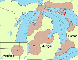
The Odawa are an Indigenous American people who primarily inhabit land in the Eastern Woodlands region, now in jurisdictions of the northeastern United States and southeastern Canada. Their territory long preceded the creation of the current border between the two countries in the 18th and 19th centuries.

The Auglaize River is a 113-mile-long (182 km) tributary of the Maumee River in northwestern Ohio in the United States. It drains a primarily rural farming area in the watershed of Lake Erie. The name of the river was derived from the French term for it. The French called it "rivière à la Grande Glaize", referring to the soil in the area.

The Ottawa River, also known as Ottawa Creek, is a short river, approximately 20 miles (32 km) long, in northwest Ohio and southeast Michigan in the United States. It drains an area on the Ohio-Michigan border along the eastern and northern fringes of the city of Toledo, goes through Ottawa Hills, and empties directly into Lake Erie. It is one of two rivers in northwestern Ohio that share the same name, along with the Ottawa River that is a tributary of the Auglaize River. The upper 4 miles (6 km) of the river in Michigan north of Sylvania, Ohio is called North Tenmile Creek on federal maps, while another branch rising in Fulton County, Ohio, is called Tenmile Creek.

The Sandusky River is a tributary to Lake Erie in north-central Ohio in the United States. It is about 133 miles (214 km) long and flows into Lake Erie at the southwest side of Sandusky Bay.
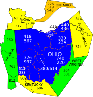
Area codes 419 and 567 are telephone area codes in the North American Numbering Plan (NANP) for the northwestern part of the U.S. state of Ohio. The largest city served by these area codes is Toledo.
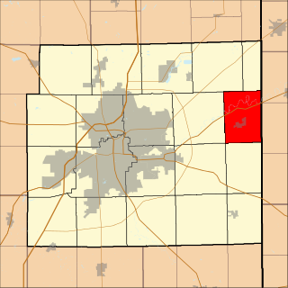
Washington Township is one of the eleven townships of Lucas County, Ohio, United States. The 2020 census found 3,055 people in the township.

The Toledo Metropolitan Area, or Greater Toledo, or Northwest Ohio is a metropolitan area centered on the American city of Toledo, Ohio. As of the 2020 census, the four-county Metropolitan Statistical Area (MSA) had a population of 646,604. It is the sixth-largest metropolitan area in the state of Ohio, behind Cincinnati–Northern Kentucky, Cleveland, Columbus, Dayton, and Akron.
Maumee Township is one of twenty townships in Allen County, Indiana, United States. As of the 2010 census, its population was 2,620.

Harvard Terrace is a historic neighborhood in Toledo, Ohio; it is "bordered by Amherst Drive, Broadway, Glendale Avenue, and the Anthony Wayne Trail. It includes 435 residences, many of them designed by architects and built in the early 1900s."
Maumee City School District is a public school district in Northwest Ohio. The school district serves students who live in the city of Maumee in Lucas County. The superintendent is Mr. Steve Lee. It comprises the following schools:

The Oliver House is a historic hotel building in Toledo, Ohio, designed by the architect Isaiah Rogers and opened in 1859. It was converted to industrial use in the 20th century and is now home to the Maumee Bay Brewing Company and its brew pub, as well as a patisserie, restaurants, event spaces, a theater company, art gallery, and residential apartments. It is listed on the National Register of Historic Places. as Successful Sales.

The Twelve Mile Square Reservation, also called the Twelve Mile Square Reserve, was a tract of land in Ohio ceded by Indians to the United States of America in the Treaty of Greenville in 1795. This particular area of land immediately surrounding Fort Miami was considered to be of strategic importance by the United States government representatives. It was subsequently surveyed in a manner different from surrounding land, and lots sold, or granted, to settlers.

North and East of the First Principal Meridian is a survey and land description in the northwest part of the U.S. state of Ohio.
Blanchard's Fork Reserve was an Ottawa Indian Reserve located in northwestern Ohio along the Blanchard River, also known as the Blanchard's Fork of the Auglaize River, a tributary of the Maumee River which ran to Lake Erie. The Reserve was established under the 1817 Treaty at the Foot of the Rapids of the Miami of Lake Erie. This group became known officially as the Ottawa of Blanchard's Fork.
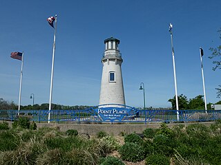
Point Place is a neighborhood on the North East corner of Toledo, Ohio. The district sits just north of the North River neighborhood and east of Washington Township. Point Place was originally part of Washington Township, Lucas County in the 1800s, and was annexed into the city of Toledo, Ohio in 1937. Point Place is surrounded by the Ottawa River, Lake Erie, the Maumee Bay and the Maumee River.
Marengo is an extinct town in Lucas County, in the U.S. state of Ohio. It was located in Adams Township, which formerly lay to the west of Toledo and has since been incorporated within the city limits.
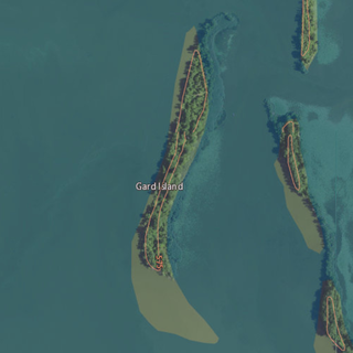
Gard Island is an island located in Maumee Bay, in Monroe County, Michigan. Its coordinates are 41°44′55″N83°26′37″W, and according to the United States Geological Survey its elevation as 568 ft (173 m) in 1980. It was labeled "Guard Island", along with Indian Island and Squaw Island, on a 1900 USGS map of the area. A 1938 map showed it alongside Indian Island, Odeen Island, and Woodtick Island.