Treaty of Greenville

Last updated

Treaty of Greenville
Treaty with the Wyandots, etc.
Treaty of Greenville page1.jpg
First page of the Treaty of Greenville
Context Northwest Indian War
SignedAugust 3, 1795
Location Fort Greenville
RatifiedDecember 22, 1795
PartiesFlag of the United States (1777-1795).svg  United States
Wyandot
Delaware
Shawanee
Odawa
Chippewa
Potawatomi
Miami
Eel Rivers
Wea
Kickapoo
Piankeshaw
Kaskaskia
Ratifiers United States Senate
LanguageEnglish
Full text
Wikisource-logo.svg Treaty of Greenville at Wikisource

The Treaty of Greenville, also known to Americans as the Treaty with the Wyandots, etc., but formally titled A treaty of peace between the United States of America, and the tribes of Indians called the Wyandots, Delawares, Shawanees, Ottawas, Chippewas, Pattawatimas, Miamis, Eel Rivers, Weas, Kickapoos, Piankeshaws, and Kaskaskias was a 1795 treaty between the United States and indigenous nations of the Northwest Territory (now Midwestern United States), including the Wyandot and Delaware peoples, that redefined the boundary between indigenous peoples' lands and territory for European American community settlement.

Contents

It was signed at Fort Greenville, [1] now Greenville, Ohio, on August 3, 1795, following the Native American loss at the Battle of Fallen Timbers a year earlier. It ended the Northwest Indian War in the Ohio Country, limited Indian country to northwestern Ohio, and began the practice of annual payments following the land concessions. The parties to the treaty were a coalition of Native American tribes known as the Western Confederacy, and the United States government represented by General Anthony Wayne and local frontiersmen.

The treaty became synonymous with the end of the frontier in that part of the Northwest Territory that would become the new state of Ohio.

Participants

One of Anthony Wayne's officers may have painted the treaty negotiations, c. 1795. Treaty of Greenville.jpg
One of Anthony Wayne's officers may have painted the treaty negotiations, c. 1795.

General "Mad Anthony" Wayne, who had led the US Army victory at Fallen Timbers and led the US government delegation. Other members included William Wells, William Henry Harrison, William Clark, Caleb Swan, and Meriwether Lewis.

Native American leaders who signed the treaty included leaders of these bands and tribes: Wyandot (chiefs Tarhe, Roundhead, and Leatherlips), Delaware (several bands). Shawnee (chiefs Blue Jacket and Black Hoof [2] ), Ottawa (several bands, including Egushawa), Chippewa, Potawatomi (23 signatories, including Gomo, Siggenauk, Black Partridge, Topinabee, and Five Medals), Miami (including Jean Baptiste Richardville, White Loon, and Little Turtle), Wea, Kickapoo, and Kaskaskia.

Following their defeat at Fallen Timbers, and subsequent scorched earth tactics, Wayne had courted the favor of several key leaders within the Western Confederacy. Wayne brought food supplies, and material for crops and promised to continue delivering new supplies. [3] Blue Jacket, the Shawnee war chief who had led the Native American force at Fallen Timbers, encouraged others to accept Wayne's terms for peace. Tarhe declared that the victory at Fallen Timbers was evidence that the Great Spirit favored the United States. Opposition to the United States was led by Little Turtle who, ironically, had advised against engaging Wayne at Fallen Timbers. For a week, Wayne urged the native tribes to accept peace based on previous terms at the Treaty of Fort McIntosh, Treaty of Fort Finney, and Treaty of Fort Harmar, but Little Turtle countered that the Miami Tribe were not party to these treaties and would not recognize them, and that they were invalid because they were made with people who had no right to the lands that they had sold. [3]

Wayne revealed that the U.S. Senate had recently ratified the Jay Treaty, ensuring that Great Britain would no longer provide aid to the Native Americans. [4] Tarhe confirmed that previous treaties had been signed by chiefs who were at Greenville and warned his fellow Indigenous tribal leaders that Wayne had the military power to take all of their lands if they did not negotiate. [3] Little Turtle and the Miami remained the lone dissent in the confederacy. At a private council between Wayne and Little Turtle on August 12, Wayne argued that the Miami chief was standing against the will of the confederate majority. Little Turtle reluctantly signed, stating that he was the last to sign, and would therefore be the last to break the treaty, even though he disagreed with the terms. [5]

The day after the Treaty of Greenville was signed, Little Turtle's wife died in camp. She was carried to a grave by US Soldiers and given a three-gun salute. [6]

The treaty was signed by President George Washington and ratified by the United States Senate on December 22, 1795. [7]

Terms

The treaty consisted of ten articles.

Land for annuity

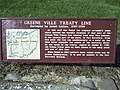
The treaty established what became known as the Greenville Treaty Line, as delineated below. For several years, it distinguished Native American territory from lands open to European-American settlers, who, however, continued to encroach. In exchange for goods to the value of $20,000 (such as blankets, utensils, and domestic animals), the Native American tribes ceded to the United States large parts of modern-day Ohio.

The treaty also established the "annuity" system of payment in return for Native American cessions of land east of the treaty line. Yearly grants of federal money and supplies of calico cloth to Native American tribes. That institutionalized continuing government influence in tribal affairs and gave outsiders considerable control over Native American life. [8] [ better source needed ]

Treaty line

The Greenville Treaty line in Ohio and Indiana Greenville Treaty Line Map.png
The Greenville Treaty line in Ohio and Indiana

The treaty redefined with slight modifications the boundaries in Ohio established previously by the Treaty of Fort McIntosh in 1785 and reasserted in the Treaty of Fort Harmar in 1789. In particular, the western boundary, which formerly ran northwesterly to the Maumee River, now ran southerly to the Ohio River. [9] [10] [11]

Ohio had developed settlements and defined tracts of land prior to 1795, including the Western Reserve, the Seven Ranges survey area, the Virginia Military District, Symmes Purchase, and two Ohio Company purchases, all in eastern and southern Ohio, as well as the line of western forts built by Wayne through Fort Recovery along the Great Miami River valley. [12] [13] [14] The boundary line would need to encompass all those territories, covering about two thirds of Ohio Country.

The treaty line began at the mouth of the Cuyahoga River in present-day Cleveland and ran south along the river to the portage between the Cuyahoga and Tuscarawas Rivers in what is now Akron, then through the Portage Lakes area between Akron and Canton. The line continued down the Tuscarawas to Fort Laurens, near present-day Bolivar. From there, the line ran west-southwest to near present-day Fort Loramie on a branch of the Great Miami River. From there, the line ran west-northwest to Fort Recovery on the Wabash River near the present-day boundary between Ohio and Indiana. From Fort Recovery, the line ran south-southwest to the Ohio River at a point opposite the mouth of the Kentucky River in present-day Carrollton, Kentucky. Rufus Putnam, who had been appointed by George Washington as surveyor general of the United States, surveyed and marked the Treaty Line. [15] [11]

Other parcels of land

There were also other forts along the Great Lakes, such as Fort Miamis and other forts in Indiana, Michigan, and Ohio that the British had agreed to cede to the United States in the 1783 Treaty of Paris but had yet to evacuate. In Indiana, there was the Vincennes Tract, Clark's Grant, and the settlement at Ouiatenon to protect. [16]

The treaty also permitted established US Army posts and allocated strategic reserved tracts within the Indian Country to the north and the west of the ceded lands, the most important of which was the future site of Fort Dearborn (now Downtown Chicago) on Lake Michigan. [nb 1] [18] Other American lands within Indian Country included Fort Detroit, Ouiatenon, Fort Wayne, [19] Fort Miami, [20] and Fort Sandusky. [21]

The treaty exempted established settlements at St. Vincennes, General Clark's grant, various French settlements, and Fort Massac from relinquishment. [11]

Miscellaneous provisions

The United States renounced all claims to indigenous peoples' lands not within the treaty line in Ohio or parcels exempted. The indigenous groups were obliged to recognize the United States as the sole sovereign power in the entire territory, but the local peoples would otherwise have free use of their own lands as long as they were kindly disposed to American settlers. The treaty also arranged for an exchange of prisoners and specified the parties that would be responsible for enforcing the boundary and punishing transgressions. [11]

Criticism

After the signing of the treaty, the so-called "peace chiefs"—such as Little Turtle—who advocated for cooperation with the United States, were roundly criticized by Shawnee chief Tecumseh, who stated that the peace chiefs had given away land that they did not own. Tecumseh fought against the Americans during the War of 1812 and was killed in battle in 1813. [22] [23]

Aftermath

Map of the northern parts of the United States of America (1804).jpg
1805 map showing western "Indian Boundary" between Port William and Fort Recovery, as well as the northern "Gen Wayne Treaty 1795" boundary between Fort Recovery and the Muskingum River 40mi. west of Salem. Much of the land east and south of these boundaries was open to settlement after the Treaty of Greenville.

The negotiated peace was only temporary. Anthony Wayne who promised to protect the treaty would die a year later. A Spanish spy James Wilkinson would take command of his army. Continuing encroachments by settlers on Indian Country north and west of the treaty line (and of future treaty lines established by the Treaty of Vincennes, Treaty of Grouseland, and Treaty of Fort Wayne of 1809), especially in Indiana, would lead a disgruntled Tecumseh, who had not signed the Treaty of Greenville, to reform the Confederacy at Prophetstown over the following decade. [24] Unrest among the tribes culminated in the Battle of Tippecanoe in 1811, a major defeat for indigenous nations that may have contributed to their siding with the British in the War of 1812. [25] [26]

The Treaty of Greenville closed the frontier in the Northwest Territory. Thereafter began a series of purchases of indigenous peoples' lands by treaty and Indigenous tribe removals by law throughout the territory and its successors, interrupted briefly by the War of 1812. Indians were moved west of the Mississippi River to Indian Country reservations in what later became the state of Oklahoma in a process that culminated with the dismantling of the Great Miami Reserve in Indiana by treaties in the 1830s. By 1840, the Old Northwest was essentially clear of indigenous peoples. Future conflicts would all be west of the Mississippi. [27]

The treaty line would become the southwestern boundary of the Northwest Territory at its division in 1800. Upon Ohio statehood in 1803, the western boundary of Ohio ran due north from a place on the Ohio River somewhat east of the south-southwesterly treaty line, leaving a sliver of land called "The Gore" in what is today southeastern Indiana remaining as part of the Northwest Territory. "The Gore" was ceded to Indiana Territory at that time, and became Dearborn County in March 1803. [28]

Meriwether Lewis and William Henry Harrison were both present at the treaty signing. The former would go on to launch the Lewis and Clark Expedition with William Clark in 1804, and the latter would later become the 9th President of the United States in 1841. [29]

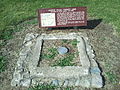
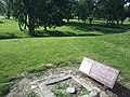
Fort Greenville was abandoned in 1796; it would be another 12 years before the settlement of Greenville, Ohio, was founded on the site. [30] [31]

It was the last treaty signed by Gen. Wayne, who died just over a year later, in December 1796. [32]

Depictions

A painting commemorating the treaty hangs in the Ohio Statehouse. It was completed by Ohio artist Howard Chandler Christy. At 23 feet (7.0 m) wide, it is the largest painting in the Ohio Statehouse. [33]

See also

Notes

  1. Six square miles centered at the mouth of the Chicago River. See Article 3, Item 14, in the text of the treaty. [17]

Related Research Articles

<span class="mw-page-title-main">Little Turtle</span> Chief of the Miami people (c. 1747 – July 14, 1812)

Little Turtle was a Sagamore (chief) of the Miami people, who became one of the most famous Native American military leaders. Historian Wiley Sword calls him "perhaps the most capable Indian leader then in the Northwest Territory," although he later signed several treaties ceding land, which caused him to lose his leader status during the battles which became a prelude to the War of 1812. In the 1790s, Mihšihkinaahkwa led a confederation of native warriors to several major victories against U.S. forces in the Northwest Indian Wars, sometimes called "Little Turtle's War", particularly St. Clair's defeat in 1791, wherein the confederation defeated General Arthur St. Clair, who lost 900 men in the most decisive loss by the U.S. Army against Native American forces.

<span class="mw-page-title-main">Miami people</span> Native American nation originally found in what is now Indiana, Michigan, and Ohio

The Miami are a Native American nation originally speaking one of the Algonquian languages. Among the peoples known as the Great Lakes tribes, they occupied territory that is now identified as north-central Indiana, southwest Michigan, and western Ohio. The Miami were historically made up of several prominent subgroups, including the Piankeshaw, Wea, Pepikokia, Kilatika, Mengakonkia, and Atchakangouen. In modern times, Miami is used more specifically to refer to the Atchakangouen. By 1846, most of the Miami had been forcefully displaced to Indian Territory. The Miami Tribe of Oklahoma are the federally recognized tribe of Miami Indians in the United States. The Miami Nation of Indiana, a nonprofit organization of self-identified descendants of Miamis who were exempted from removal, have unsuccessfully sought separate recognition.

<span class="mw-page-title-main">Northwest Territory</span> United States territory (1787–1803)

The Northwest Territory, also known as the Old Northwest and formally known as the Territory Northwest of the River Ohio, was formed from unorganized western territory of the United States after the American Revolution. Established in 1787 by the Congress of the Confederation through the Northwest Ordinance, it was the nation's first post-colonial organized incorporated territory.

<span class="mw-page-title-main">Battle of Fallen Timbers</span> Battle of the Northwest Indian War fought in 1794

The Battle of Fallen Timbers was the final battle of the Northwest Indian War, a struggle between Native American tribes affiliated with the Northwestern Confederacy and their British allies, against the nascent United States for control of the Northwest Territory. The battle took place amid trees toppled by a tornado near the Maumee River in northwestern Ohio at the site of the present-day city of Maumee, Ohio.

<span class="mw-page-title-main">Tecumseh's War</span> 1810-13 conflict between the US and Tecumsehs Confederacy

Tecumseh's War or Tecumseh's Rebellion was a conflict between the United States and Tecumseh's Confederacy, led by the Shawnee leader Tecumseh in the Indiana Territory. Although the war is often considered to have climaxed with William Henry Harrison's victory at the Battle of Tippecanoe in 1811, Tecumseh's War essentially continued into the War of 1812 and is frequently considered a part of that larger struggle. The war lasted for two more years, until 1813, when Tecumseh and his second-in-command, Roundhead, died fighting Harrison's Army of the Northwest at the Battle of the Thames in Upper Canada, near present-day Chatham, Ontario, and his confederacy disintegrated. Tecumseh's War is viewed by some academic historians as the final conflict of a longer-term military struggle for control of the Great Lakes region of North America, encompassing a number of wars over several generations, referred to as the Sixty Years' War.

<span class="mw-page-title-main">Northwest Indian War</span> Part of the American Indian Wars (1785 to 1795)

The Northwest Indian War (1785–1795), also known by other names, was an armed conflict for control of the Northwest Territory fought between the United States and a united group of Native American nations known today as the Northwestern Confederacy. The United States Army considers it the first of the American Indian Wars.

<span class="mw-page-title-main">Wea</span> Native American tribe originally located in western Indiana

The Wea were a Miami-Illinois-speaking Native American tribe originally located in western Indiana. Historically, they were described as either being closely related to the Miami Tribe or a sub-tribe of Miami.

<span class="mw-page-title-main">Jean Baptiste Richardville</span> Chief of the Miami people

Jean Baptiste de Richardville, also known as Pinšiwa or Peshewa in the Miami-Illinois language or John Richardville in English, was the last akima 'civil chief' of the Miami people. He began his career in the 1790s as a fur trader who controlled an important portage connecting the Maumee River to the Little River in what became the present-day state of Indiana. Richardville emerged a principal chief in 1816 and remained a leader of the Miamis until his death in 1841. He was a signatory to the Treaty of Greenville (1795), as well as several later treaties between the U.S. government and the Miami people, most notably the Treaty of Fort Wayne (1803), the Treaty of Fort Wayne (1809), the Treaty of Saint Mary's (1818), the Treaty of Mississinewas (1826), the treaty signed at the Forks of the Wabash (1838), and the Treaty of the Wabash (1840).

<span class="mw-page-title-main">Fort Recovery</span> United States historic place

Fort Recovery was a United States Army fort ordered built by General "Mad" Anthony Wayne during what is now termed the Northwest Indian War. Constructed from late 1793 and completed in March 1794, the fort was built along the Wabash River, within two miles of what became the Ohio state border with Indiana. A detachment of Wayne's Legion of the United States held off an attack from combined Indian forces on June 30, 1794. The fort was used as a reference in drawing treaty lines for the 1795 Treaty of Greenville, and for later settlement. The fort was abandoned in 1796.

<span class="mw-page-title-main">Treaty of St. Mary's (1818)</span> 1818 treaties between the United States and Native Americans

The Treaty of St. Mary's may refer to one of six treaties concluded in fall of 1818 between the United States and Natives of central Indiana regarding purchase of Native land. The treaties were

The Treaty of Fort McIntosh was a treaty between the United States government and representatives of the Wyandotte, Delaware, Chippewa and Ottawa nations of Native Americans. The treaty was signed at Fort McIntosh on January 21, 1785. It contained 10 articles and an addendum.

<span class="mw-page-title-main">Treaty of Fort Harmar</span> 1789 treaty between United States and Native Americans

The Treaty of Fort Harmar (1789) was an agreement between the United States government and numerous Native American tribes with claims to the Northwest Territory.

<span class="mw-page-title-main">Treaty of Fort Meigs</span> 1817 treaty between the United States and Native Americans

The Treaty of Fort Meigs, also called the Treaty of the Maumee Rapids, formally titled, "Treaty with the Wyandots, etc., 1817", was the most significant Indian treaty by the United States in Ohio since the Treaty of Greenville in 1795. It resulted in cession by bands of several tribes of nearly all their remaining Indian lands in northwestern Ohio. It was the largest wholesale purchase by the United States of Indian land in the Ohio area. It was also the penultimate one; a small area below the St. Mary's River and north of the Greenville Treaty Line was ceded in the Treaty of St. Mary's in 1818.

<span class="mw-page-title-main">Treaty of Fort Wayne (1809)</span> 1809 treaty between the United States and Native Americans

The Treaty of Fort Wayne, sometimes called the Ten O'clock Line Treaty or the Twelve Mile Line Treaty, is an 1809 treaty that obtained 29,719,530 acres of Native American land for the settlers of Illinois and Indiana. The negotiations primarily involved the Delaware tribe but included other tribes as well. However, the negotiations excluded the Shawnee, who were minor inhabitants of the area and had previously been asked to leave by Miami War Chief Little Turtle. Territorial Governor William Henry Harrison negotiated the treaty with the tribes. The treaty led to a war with the United States begun by Shawnee leader Tecumseh and other dissenting tribesmen in what came to be called "Tecumseh's War".

<span class="mw-page-title-main">Northwestern Confederacy</span> Confederation of Native American tribes in the Great Lakes region

The Northwestern Confederacy, or Northwestern Indian Confederacy, was a loose confederacy of Native Americans in the Great Lakes region of the United States created after the American Revolutionary War. Formally, the confederacy referred to itself as the United Indian Nations, at their Confederate Council. It was known infrequently as the Miami Confederacy since many contemporaneous federal officials overestimated the influence and numerical strength of the Miami tribes based on the size of their principal city, Kekionga.

<span class="mw-page-title-main">Treaty of Grouseland</span> 1805 treaty between the United States and Native Americans

The Treaty of Grouseland was an agreement negotiated by Governor William Henry Harrison of the Indiana Territory on behalf of the government of the United States of America with Native American leaders, including Little Turtle and Buckongahelas, for lands in Southern Indiana, northeast Indiana, and northwestern Ohio. The treaty was negotiated and signed on Aug 21, 1805, at Harrison's home in Vincennes, Indiana, called Grouseland. Negotiated a year after the second Treaty of Vincennes, it was the second major land purchase in Indiana since the close of the Northwest Indian War and the signing of the 1795 Treaty of Greenville.

<span class="mw-page-title-main">Treaty of Fort Wayne (1803)</span> 1803 treaty between the United States and Native Americans

The Treaty of Fort Wayne was a treaty between the United States and several groups of Native Americans. The treaty was signed on June 7, 1803 and proclaimed December 26, 1803. It more precisely defined the boundaries of the Vincennes tract ceded to the United States by the Treaty of Greenville, 1795.

<span class="mw-page-title-main">Tecumseh's confederacy</span> 19th century Native American confederation in the Great Lakes region

Tecumseh's confederacy was a confederation of indigenous peoples of the Great Lakes region of North America that began to form in the early 19th century around the teaching of Tenskwatawa, called The Prophet by his followers. The confederation grew over several years and came to include several thousand warriors. Shawnee leader Tecumseh, the brother of The Prophet, developed into the leader of the group as early as 1808. Together, they worked to unite the various tribes against the European settlers who had been crossing the Appalachian Mountains and settling on their land.

Indian removals in Ohio started in the late eighteenth century after the American victory in the Revolutionary War and the consequent opening of the Northwestern United States to European-American settlement. Native American tribes residing in the region banded together to resist settlement, resulting in the disastrous Northwest Indian War where the Native tribes ceded large swathes of territory to the American government. After the American victory in the war, several Indian reservations were established to forcibly relocate landless tribes to. The process of obtaining full American sovereignty over Indian territories in Ohio was complete around 1818, but continued in Indiana until 1840.

References

  1. for Nathanael Greene, a Major General in the Revolutionary War
  2. "Address of Black Hoof, 5 February 1802" . Retrieved October 26, 2019 via National Archives.
  3. 1 2 3 Stockwell, Mary (2018). Unlikely General. 'Mad' Anthony Wayne and the Battle for America. New Haven: Yale University Press. pp. 282–283. ISBN   978-0-300-21475-8. LCCN   2017953580.
  4. Nelson, Paul David (1985). Anthony Wayne, Soldier of the Early Republic. Bloomington: Indiana University Press. p.  282. ISBN   0253307511.
  5. Sword, Wiley (1985). President Washington's Indian War: The Struggle for the Old Northwest, 1790–1795. Norman: University of Oklahoma Press. pp. 326–331. ISBN   0-8061-2488-1.
  6. Sword, Wiley (1985). President Washington's Indian War: The Struggle for the Old Northwest, 1790–1795. Norman: University of Oklahoma Press. p. 331. ISBN   0-8061-2488-1.
  7. Gaff, Alan D. (2004). Bayonets in the Wilderness. Anthony Waynes Legion in the Old Northwest. Norman: University of Oklahoma Press. p. 366. ISBN   0-8061-3585-9.
  8. Eric Foner, Give Me Liberty
  9. "Treaty With The Wyandot, Etc., 1785". Oklahoma State University Libraries Tribal Treaties Database.
  10. "Treaty With The Wyandot, Etc., 1789". Oklahoma State University Libraries Tribal Treaties Database.
  11. 1 2 3 4 "Treaty With The Wyandot, Etc., 1795". Oklahoma State University Libraries Tribal Treaties Database.
  12. Barrow, William C. (August 3, 2020). "Western Reserve". Case Western Reserve University Encyclopedia of Cleveland History.
  13. Knepper, George W. (2002). The Official Ohio Lands Book. The Auditor of the State of Ohio.
  14. "History & Heritage". Symmes Township. Archived from the original on February 8, 2015.
  15. Hubbard, Robert Ernest. General Rufus Putnam: George Washington's Chief Military Engineer and the "Father of Ohio," pp. 151–152, McFarland & Company, Inc., Jefferson, North Carolina, 2020. ISBN   978-1-4766-7862-7.
  16. Benn, Carl (1993). Historic Fort York, 1793–1993. Dundurn Press Ltd. p. 17. ISBN   978-0-920474-79-2.
  17. "Treaty with The Wyandot etc – 1795". www.firstpeople.us. Retrieved June 6, 2019.
  18. "Fort Dearborn". www.encyclopedia.chicagohistory.org. Retrieved August 1, 2008.
  19. Ann Durkin Keating, Rising Up from Indian Country: the battle of Fort Dearborn and the Birth of Chicago (University of Chicago Press 2012) p. 40 ISBN   978-0226428963
  20. see Article 3 #8
  21. see Article 3 #11
  22. Miller, Robert (July 2009). "Tecumseh". ResearchGate.
  23. Gugin, Linda C.; St. Clair, James E. (2015). Indiana's 200: The People Who Shaped the Hoosier State. Indianapolis: Indiana Historical Society Press. p. 234. ISBN   978-0-87195-387-2.
  24. Hemenway Eric; Little Traverse Bay Bands of Odawa Indians. "Summer 1795: The Treaty of Greenville creates an uneasy peace". National Park Service . Retrieved April 21, 2020.
  25. Heidler, David; Heidler, Jeanne T. "Courting Victory: British, Native and American alliances". National Park Service.
  26. "Autumn 1811: The Battle of Tippecanoe". National Park Service.
  27. "Treaties". Oklahoma State University Libraries Tribal Treaties Database.
  28. "A special slice of Indiana with a unique history". Tribune-Star . October 5, 2014.
  29. "Lewis and Clark—Indiana Connections". The Indiana Historian: 1. 2003 via IN.gov.
  30. "Fort Greenville (Ohio)". The Archaeological Conservancy. November 28, 2014.
  31. Tikkanen, Amy. "Greenville". Encyclopedia Britannica.
  32. "Wayne, General Anthony". Detroit Historical Society.
  33. "Capitol Ohio : The Treaty Of Greenville (Art Walk Series)". Ohio Statehouse.

40°06′28″N84°37′54″W / 40.1078°N 84.6316°W / 40.1078; -84.6316