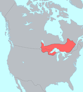
The Ojibwe are an Anishinaabe people whose homeland covers much of the Great Lakes region and the northern plains, extending into the subarctic and throughout the northeastern woodlands. Ojibweg, being Indigenous peoples of the Northeastern Woodlands and of the subarctic, are known by several names, including Ojibway or Chippewa. As a large ethnic group, several distinct nations also consider themselves Ojibwe, including the Saulteaux, Nipissings, and Oji-Cree.

The Potawatomi, also spelled Pottawatomi and Pottawatomie, are a Native American people of the Great Plains, upper Mississippi River, and western Great Lakes region. They traditionally speak the Potawatomi language, a member of the Algonquian family. The Potawatomi call themselves Neshnabé, a cognate of the word Anishinaabe. The Potawatomi are part of a long-term alliance, called the Council of Three Fires, with the Ojibwe and Odawa (Ottawa). In the Council of Three Fires, the Potawatomi are considered the "youngest brother". Their people are referred to in this context as Bodéwadmi, a name that means "keepers of the fire" and refers to the council fire of three peoples.

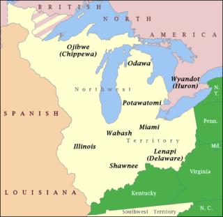
The Treaty of Greenville, also known to Americans as the Treaty with the Wyandots, etc., but formally titled A treaty of peace between the United States of America, and the tribes of Indians called the Wyandots, Delawares, Shawanees, Ottawas, Chippewas, Pattawatimas, Miamis, Eel Rivers, Weas, Kickapoos, Piankeshaws, and Kaskaskias was a 1795 treaty between the United States and indigenous nations of the Northwest Territory, including the Wyandot and Delaware peoples, that redefined the boundary between indigenous peoples' lands and territory for European American community settlement.

The Territory of Michigan was an organized incorporated territory of the United States that existed from June 30, 1805, until January 26, 1837, when the final extent of the territory was admitted to the Union as the State of Michigan. Detroit was the territorial capital.

The Odawa are an Indigenous American people who primarily inhabit land in the Eastern Woodlands region, now in jurisdictions of the northeastern United States and southeastern Canada. Their territory long preceded the creation of the current border between the two countries in the 18th and 19th centuries.

The Treaty of Saginaw, also known as the Treaty with the Chippewa, was made between Gen. Lewis Cass and Chief Mash Kee Yosh, Chief John Okemos, Chief Wasso and other Native American tribes of the Great Lakes region in what is now the United States, on September 24, 1819, proclaimed by the President of the United States on March 25, 1820, and placed in law as 7 Stat. 203.
Whitmore Knaggs was a fighter, linguist and spy.

The Treaty of St. Mary's may refer to one of six treaties concluded in fall of 1818 between the United States and Natives of central Indiana regarding purchase of Native land. The treaties were
White Rock is an unincorporated community in Huron County in the U.S. state of Michigan. The community is located within Sherman Township. As an unincorporated community, White Rock has no legal autonomy, defined boundaries, or population statistics of its own. It is located at 43°42′35″N82°36′31″W, about three miles north of Forestville and about nine miles south of Harbor Beach on M-25 at the junction with White Rock Road.

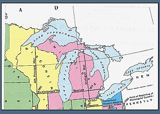
The Michigan meridian is the principal meridian used as a reference in the Michigan Survey, the survey of the U.S. state of Michigan in the early 19th century. It is located at 84 degrees, 21 minutes and 53 seconds west longitude. It forms the boundary between several counties in the state.

The Treaty of Fort Meigs, also called the Treaty of the Maumee Rapids, formally titled, "Treaty with the Wyandots, etc., 1817", was the most significant Indian treaty by the United States in Ohio since the Treaty of Greenville in 1795. It resulted in cession by bands of several tribes of nearly all their remaining Indian lands in northwestern Ohio. It was the largest wholesale purchase by the United States of Indian land in the Ohio area. It was also the penultimate one; a small area below the St. Mary's River and north of the Greenville Treaty Line was ceded in the Treaty of St. Mary's in 1818.

Fort Pontchartrain du Détroit or Fort Detroit (1701–1796) was a French and later British fortification established in 1701 on the north side of the Detroit River by Antoine Laumet de Lamothe Cadillac. A settlement based on the fur trade, farming and missionary work slowly developed in the area. The fort was located in what is now downtown Detroit, northeast of the intersection of Washington Boulevard and West Jefferson Avenue.

The Treaty of Fort Industry was a successor treaty to the Treaty of Greenville, which moved the eastern boundary of Indian lands in northern Ohio from the Tuscarawas River and Cuyahoga River westward to a line 120 miles west of the Pennsylvania boundary, which coincided with the western boundary of the Firelands of the Connecticut Western Reserve. In return, the United States agreed "every year forever hereafter, at Detroit, or some other convenient place" to pay $825 for the ceded lands south of the 41st degree of north latitude, and an additional $175 for the Firelands, which lie north of 41 degrees north, which the President would secure from the Connecticut Land Company, for a total of annuity $1000.00, to be "divided between said nations, from time to time, in such proportions as said nations, with the approbation of the President, shall agree."
Egushawa, also spelled Egouch-e-ouay, Agushaway, Agashawa, Gushgushagwa, Negushwa, and many other variants, was a war chief and principal political chief of the Ottawa tribe of North American Indians. His name is loosely translated as "The Gatherer" or "Brings Together". He was a prominent leader among the Detroit Ottawa, a prominent group in southeast Michigan and northwest Ohio. Egushawa is considered a successor to Chief Pontiac. As a leader in two wars against the United States, Egushawa was one of the most influential Native Americans of the Great Lakes region in the late eighteenth century.

The Northwestern Confederacy, or Northwestern Indian Confederacy, was a loose confederacy of Native Americans in the Great Lakes region of the United States created after the American Revolutionary War. Formally, the confederacy referred to itself as the United Indian Nations, at their Confederate Council. It was known infrequently as the Miami Confederacy since many contemporaneous federal officials overestimated the influence and numerical strength of the Miami tribes based on the size of their principal city, Kekionga.

Lake Erie Basin consists of Lake Erie and surrounding watersheds, which are typically named after the river, creek, or stream that provides drainage into the lake. The watersheds are located in the states of Indiana, Michigan, New York, Ohio, and Pennsylvania in the United States, and in the province of Ontario in Canada. The basin is part of the Great Lakes Basin and Saint Lawrence River Watershed, which feeds into the Atlantic Ocean. 80% of the lake's water flows in from the Detroit River, with only 9% coming from all of the remaining watersheds combined. A littoral zone serves as the interface between land and lake, being that portion of the basin where the lake is less than 15 feet (4.6 m) in depth.

The Treaty of Brownstown was between the United States and the Council of Three Fires, Wyandott, and Shawanoese Indian Nations. It was concluded November 25, 1808, at Brownstown in Michigan Territory, and provided cession of a strip of Indian land for a road to connect two disconnected areas of land previously ceded by Indians in Michigan and Ohio.
Indian removals in Ohio started in the late eighteenth century after the American victory in the Revolutionary War and the consequent opening of the Northwestern United States to European-American settlement. Native American tribes residing in the region banded together to resist settlement, resulting in the disastrous Northwest Indian War where the Native tribes ceded large swathes of territory to the American government. After the American victory in the war, several Indian reservations were established to forcibly relocate landless tribes to. The process of obtaining full American sovereignty over Indian territories in Ohio was complete around 1818, but continued in Indiana until 1840.


