Treaty of Fort Meigs

Last updated
The treaty ceded the lighter yellow area (87) south of the Maumee and Lake Erie and north of the Greenville Treaty Line. Royce-areas-ohio.jpg
The treaty ceded the lighter yellow area (87) south of the Maumee and Lake Erie and north of the Greenville Treaty Line.

The Treaty of Fort Meigs, also called the Treaty of the Maumee Rapids, formally titled, "Treaty with the Wyandots, etc., 1817", was the most significant Indian treaty by the United States in Ohio since the Treaty of Greenville in 1795. It resulted in cession by bands of several tribes of nearly all their remaining Indian lands in northwestern Ohio. It was the largest wholesale purchase by the United States of Indian land in the Ohio area. It was also the penultimate one; a small area below the St. Mary's River and north of the Greenville Treaty Line was ceded in the Treaty of St. Mary's in 1818.

Contents

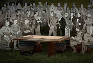
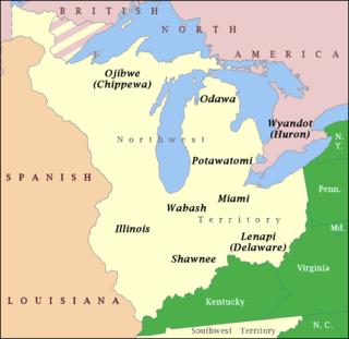
The Treaty was signed September 29, 1817 at Fort Meigs between those chiefs and warriors of the Wyandot, Seneca, Delaware, Shawnee, Potawatomi, Ottawa and Chippewa (also known as the Ojibwe) tribes of Native Americans and official representatives of the United States of America: Lewis Cass, governor of Michigan Territory, and Gen. Duncan McArthur of Ohio. These historic tribes spoke a variety of distinct Iroquoian and Algonquian languages. The tribes were highly decentralized; others of their members lived in other regions around the Great Lakes.

The accord contained twenty-one articles and an addendum specifying land cession, allocation of Indian reservations and individual land grants, cash compensation to be paid by the United States, and acceptance of the terms by the various tribes.

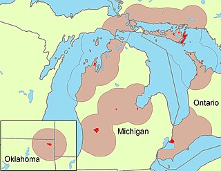
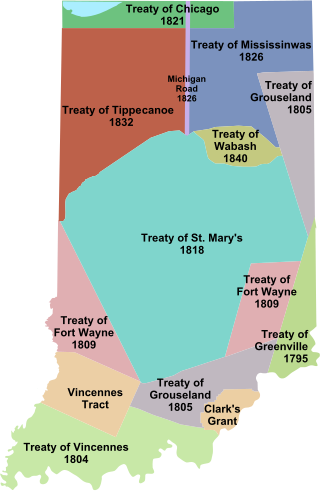
In this treaty the affiliated tribes relinquished their claim to 4.6 million acres of land in northwestern Ohio (almost 1/6 of the land area of the state), and chunks of northeastern Indiana and southern Michigan as well. The area was bounded by the Fort Industry Treaty Line in the East and the Greenville Treaty Line in the south; the western boundary angled northerly from the northwest corner of the Greenville Line (skipping around a small reservation near Loramie's store) to Kekionga, then zigzagged awkwardly northwest to Lake Erie, clipping off a chunk of southeastern Michigan; the northeastern boundary was Lake Erie. In a figurative way, the land cession was the inverse of that in the pre-Greenville Treaty of Fort McIntosh: in the Fort McIntosh Treaty, the circumscribed area, which included most of northwestern and central northern Ohio, was land reserved to the Indians; in the Fort Meigs Treaty, the circumscribed area, which included most of northwestern Ohio, is land ceded to the United States. After the treaty, with the exception of some tiny Indian reservations, Ohio was owned border to border by a United States dominated by European Americans (commonly referred to as whites). The border between ancestral Indian lands to the northwest and United States lands dominated by European Americans to the south and east shifted to Indiana. There the frontier was defined by the Treaty of Fort Wayne (1809).

The treaty of Fort Meigs reserved: for the Wyandot 12 miles square in Upper Sandusky around Fort Ferree; for the Seneca, thirty thousand acres on the Sandusky River near Wolf Creek; for the Shawnee, 10 miles square around Wapakoneta, also for the Shawnee, 25 square miles around Wapakoneta, also for the Shawnee, 48 square miles near of the headwaters of the Little Miami and Scioto Rivers. The Ottawa were granted use but not occupancy as reservations of two tracts, one 5 miles square on the Great Auglaize River and one 3 miles square on the Little Auglaize River. The Delaware, who occupied territory south of the Wabash River; the Chippewa or Ojibwe, who had migrated from northern Wisconsin and Minnesota; and the Potawatomi from the upper Mississippi Valley, were not allocated any reservations in Ohio.

In compensation, the United States agreed to pay annuities of various amounts for different lengths of time to the different tribes depending on their relative occupancy of the land. In addition, some tribes were paid cash amounts for damages they suffered as a result of allying with the United States against Great Britain in the War of 1812.

The treaty introduced the practice of making grants of land to individual Indians and sometimes to European Americans to encourage them to settle and farm the land. But these Indians were nomadic. As the resettlement and assimilation scheme to reservations failed, the government bought back the lands of the reservations, and resold them to whites. This resulted in speculation and fraud.

The Treaty was signed five days after the laying of the cornerstone for the fledgling University of Michigan campus in Detroit. Among the treaty's provisions was the ceding of 1,920 acres (7.8 km2) of land by the Chippewa, Ottawa, and Potawatomi tribes to the "college at Detroit" for either use or sale, and an equal amount to St. Anne's Catholic Church in Detroit, where Father Gabriel Richard was rector. French-Canadian settlers had established this church well before the territory became part of the US.

No college had officially been created yet by the Michigan territorial legislature, so the next month Reverend John Monteith and Father Richard decreed the creation of the " Catholepistemiad [2] of Michigania" at Detroit. It was renamed as the University of Michigan in 1821. It moved to a new campus developed in Ann Arbor, Michigan in 1837.

Addendum

The Addendum was a separate document also signed on September 29, 1817. The United States granted the Wyandot (Huron), Seneca, Shawnee, and Ottawa peoples additional sums of money for their lands. In addition, the terms of the original treaty were changed to give the Indians ownership of Indian lands instead of just use of them, effectively creating Indian reservations.

See also

Related Research Articles

<span class="mw-page-title-main">Potawatomi</span> Native American people of the Great Plains

The Potawatomi, also spelled Pottawatomi and Pottawatomie, are a Native American people of the Great Plains, upper Mississippi River, and western Great Lakes region. They traditionally speak the Potawatomi language, a member of the Algonquin family. The Potawatomi call themselves Neshnabé, a cognate of the word Anishinaabe. The Potawatomi are part of a long-term alliance, called the Council of Three Fires, with the Ojibway and Odawa (Ottawa). In the Council of Three Fires, the Potawatomi are considered the "youngest brother" and are referred to in this context as Bodéwadmi, a name that means "keepers of the fire" and refers to the council fire of three peoples.

<span class="mw-page-title-main">Treaty of Greenville</span> 1795 treaty ending the Northwest Indian War

The Treaty of Greenville, also known to Americans as the Treaty with the Wyandots, etc., but formally titled A treaty of peace between the United States of America, and the tribes of Indians called the Wyandots, Delawares, Shawanees, Ottawas, Chippewas, Pattawatimas, Miamis, Eel Rivers, Weas, Kickapoos, Piankeshaws, and Kaskaskias was a 1795 treaty between the United States and indigenous nations of the Northwest Territory, including the Wyandot and Delaware peoples, that redefined the boundary between indigenous peoples' lands and territory for European American community settlement.

<span class="mw-page-title-main">Odawa</span> Indigenous people of North America

The Odawa are an Indigenous American people who primarily inhabit land in the Eastern Woodlands region, now in jurisdictions of the northeastern United States and southeastern Canada. Their territory long preceded the creation of the current border between the two countries in the 18th and 19th centuries.

<span class="mw-page-title-main">Treaty of Saginaw</span> 1819 treaty between the United States and Native Americans

The Treaty of Saginaw, also known as the Treaty with the Chippewa, was made between Gen. Lewis Cass and Chief Mash Kee Yosh, Chief John Okemos, Chief Wasso and other Native American tribes of the Great Lakes region in what is now the United States, on September 24, 1819, proclaimed by the President of the United States on March 25, 1820, and placed in law as 7 Stat. 203.

Match-E-Be-Nash-She-Wish was a hereditary chief of a Potawatomi Indian group in what is now Michigan. The Potawatomi are one of the peoples of the Council of Three Fires; the others are the Odawa and the Ojibwe, all Algonquian-language speakers.

<span class="mw-page-title-main">Treaty of St. Mary's (1818)</span> 1818 treaties between the United States and Native Americans

The Treaty of St. Mary's may refer to one of six treaties concluded in fall of 1818 between the United States and Natives of central Indiana regarding purchase of Native land. The treaties were

<span class="mw-page-title-main">Treaty of Detroit</span> 1807 treaty between the United States and Native Americans

The Treaty of Detroit was a treaty between the United States and the Ottawa, Chippewa, Wyandot and Potawatomi Native American nations. The treaty was signed in Detroit, Michigan on November 17, 1807, with William Hull, governor of the Michigan Territory and superintendent of Indian affairs, the sole representative of the U.S.

<span class="mw-page-title-main">Treaty of Fort Industry</span> 1805 treaty between the United States and Native Americans

The Treaty of Fort Industry was a successor treaty to the Treaty of Greenville, which moved the eastern boundary of Indian lands in northern Ohio from the Tuscarawas River and Cuyahoga River westward to a line 120 miles west of the Pennsylvania boundary, which coincided with the western boundary of the Firelands of the Connecticut Western Reserve. In return, the United States agreed "every year forever hereafter, at Detroit, or some other convenient place" to pay $825 for the ceded lands south of the 41st degree of north latitude, and an additional $175 for the Firelands, which lie north of 41 degrees north, which the President would secure from the Connecticut Land Company, for a total of annuity $1000.00, to be "divided between said nations, from time to time, in such proportions as said nations, with the approbation of the President, shall agree."

<span class="mw-page-title-main">Treaty of Spring Wells</span> 1815 treaty between the United States and Native Americans

The Treaty of Spring Wells was an agreement between the United States and the Wyandot, Delaware, Seneca, Shawnee, Miami, Chippewa, Ottawa, and Potawatomi Native Americans, ending the conflict between the U.S. and these Native Americans that was part of the War of 1812. It was signed on September 8, 1815, at the present site of the Fort Wayne historical site in Detroit, Michigan.

<span class="mw-page-title-main">Northwestern Confederacy</span> Confederation of Native American tribes in the Great Lakes region

The Northwestern Confederacy, or Northwestern Indian Confederacy, was a loose confederacy of Native Americans in the Great Lakes region of the United States created after the American Revolutionary War. Formally, the confederacy referred to itself as the United Indian Nations, at their Confederate Council. It was known infrequently as the Miami Confederacy since many contemporaneous federal officials overestimated the influence and numerical strength of the Miami tribes based on the size of their principal city, Kekionga.

Snake was the English language name of two Shawnee leaders prominent in the history of the Ohio Country: Peteusha and Shemanetoo. They were both commonly referred to as "Snake" in historical records, or by variations such as "Black Snake" or "Captain Snake," so it is often difficult to determine which individual was being referred to. On a number of occasions, the two Snakes both signed a letter or appeared together, so it is clear they were two different people. There may have been additional Shawnees called "Snake," further complicating the matter. According to historian John Sugden, "it is unlikely if the biographies of these chiefs will ever be completely disentangled."

<span class="mw-page-title-main">Indian removals in Indiana</span> Removal of native tribes from Indiana

Indian removals in Indiana followed a series of the land cession treaties made between 1795 and 1846 that led to the removal of most of the native tribes from Indiana. Some of the removals occurred prior to 1830, but most took place between 1830 and 1846. The Lenape (Delaware), Piankashaw, Kickapoo, Wea, and Shawnee were removed in the 1820s and 1830s, but the Potawatomi and Miami removals in the 1830s and 1840s were more gradual and incomplete, and not all of Indiana's Native Americans voluntarily left the state. The most well-known resistance effort in Indiana was the forced removal of Chief Menominee and his Yellow River band of Potawatomi in what became known as the Potawatomi Trail of Death in 1838, in which 859 Potawatomi were removed to Kansas and at least forty died on the journey west. The Miami were the last to be removed from Indiana, but tribal leaders delayed the process until 1846. Many of the Miami were permitted to remain on land allotments guaranteed to them under the Treaty of St. Mary's (1818) and subsequent treaties.

<span class="mw-page-title-main">Treaty of Fort Wayne (1803)</span> 1803 treaty between the United States and Native Americans

The Treaty of Fort Wayne was a treaty between the United States and several groups of Native Americans. The treaty was signed on June 7, 1803 and proclaimed December 26, 1803. It more precisely defined the boundaries of the Vincennes tract ceded to the United States by the Treaty of Greenville, 1795.

<span class="mw-page-title-main">Treaty of Brownstown</span> 1808 treaty between the United States and Native Americans

The Treaty of Brownstown was between the United States and the Council of Three Fires, Wyandott, and Shawanoese Indian Nations. It was concluded November 25, 1808, at Brownstown in Michigan Territory, and provided cession of a strip of Indian land for a road to connect two disconnected areas of land previously ceded by Indians in Michigan and Ohio.

Turnpike Lands were a group of land tracts granted by the United States Congress to the state of Ohio in 1827 along the path of a proposed road in the northwest corner of the state.

<span class="mw-page-title-main">Indian Land Grants</span>

Indian Land Grants were land tracts granted to various Indians by Treaty or by United States Congressional action in the Nineteenth century in northwestern Ohio.

Jacob Smith, was a fur trader in the Michigan Territory, the founder of Flint, Michigan, and an American spy best known for developing close relations with many Native American tribes in the Michigan Territory and brokering significant land treaties on behalf of the United States government.

Indian removals in Ohio started in the late eighteenth century after the American victory in the Revolutionary War and the consequent opening of the Northwestern United States to European-American settlement. Native American tribes residing in the region banded together to resist settlement, resulting in the disastrous Northwest Indian War where the Native tribes ceded large swathes of territory to the American government. After the American victory in the war, several Indian reservations were established to forcibly relocate landless tribes to. The process of obtaining full American sovereignty over Indian territories in Ohio was complete around 1818, but continued in Indiana until 1840.

<span class="mw-page-title-main">John Lewis (Shawnee leader)</span> Shawnee leader

Quatawapea or John Lewis, also known as Captain Lewis and Colonel Lewis and ‘’’Captain Johnny’’’, was a Shawnee leader for whom Lewistown, Ohio, is named.

References

  1. Part of the treaty area in Indiana is off the map to the upper left.
  2. From Latin cathol-, "universal" + Greek episte-, "letter of knowledge" + Greek -[m]iad, "event"; loosely, "academy of universal knowledge". It was an awkwardly coined term, and probably the only instance of the word in the English language.