Wabash and Erie Canal

Last updated
Wabash and Erie Canal
Wabash and Erie Canal (Delphi).png
A restored section of canal in Delphi, Indiana
USA Indiana location map.svg
Red pog.svg
Location of Wabash and Erie Canal in Indiana

The Wabash and Erie Canal was a shipping canal that linked the Great Lakes to the Ohio River via an artificial waterway. The canal provided traders with access from the Great Lakes all the way to the Gulf of Mexico. Over 460 miles long, it was the longest canal ever built in North America.

Contents

The canal known as the Wabash & Erie in the 1850s and thereafter, was actually a combination of four canals: the Miami and Erie Canal from the Maumee River near Toledo, Ohio, to Junction, Ohio, the original Wabash and Erie Canal from Junction to Terre Haute, Indiana, the Cross Cut Canal from Terre Haute, Indiana, to Worthington, Indiana (Point Commerce), and the Central Canal from Worthington to Evansville, Indiana.

Construction

1850 Michigan Southern.jpg
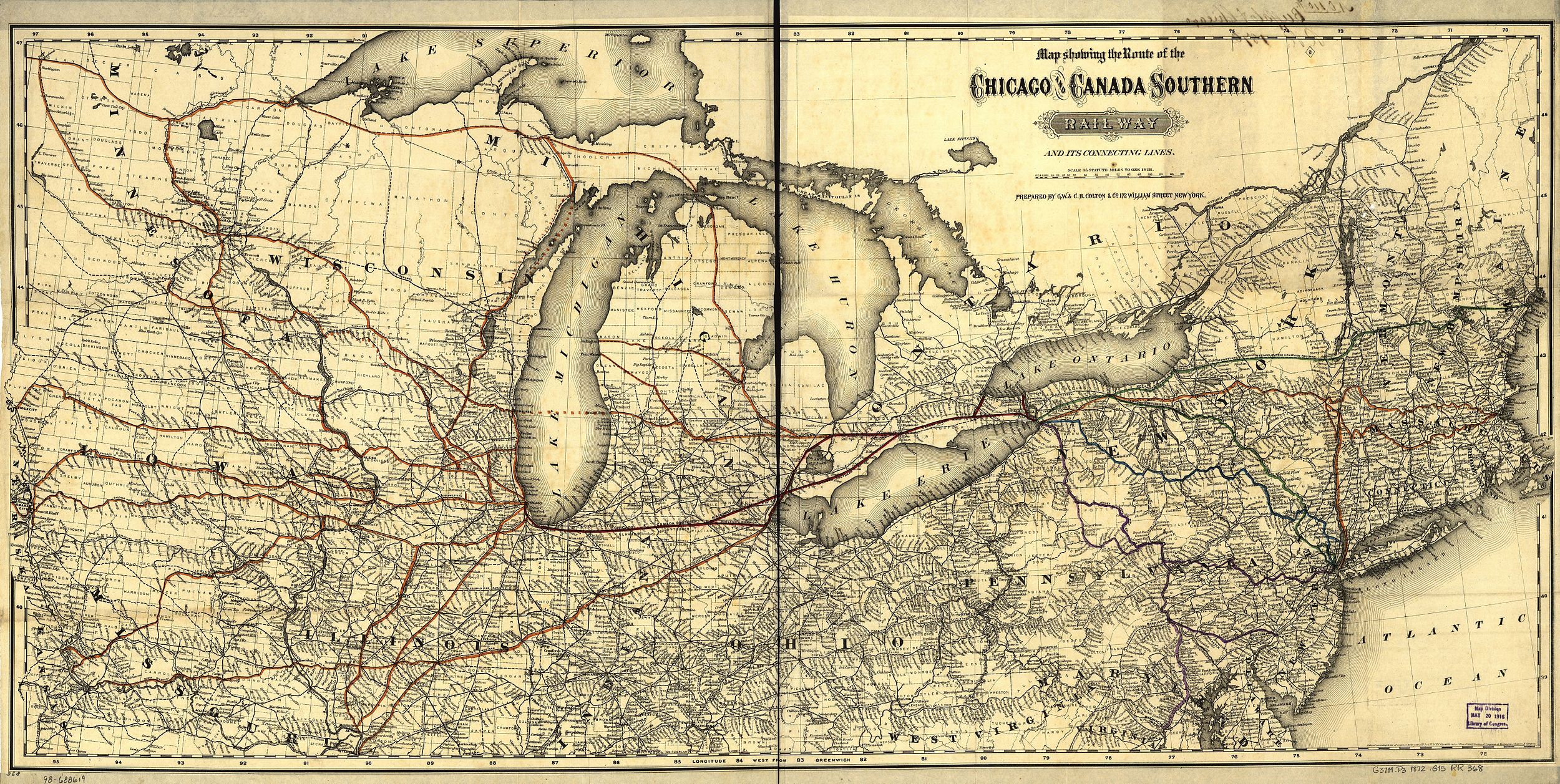
In this 1850 map, the original Wabash and Erie Canal is shown as part of an emerging system of canals and rail lines
1872 Chicago & Canada Southern.jpg
by 1872, the Toledo, Wabash and Western Railway (shown in red) connected Toledo, Fort Wayne, and Lafayette. The original canal, with its slow pace and maintenance issues, struggled to compete with many rail lines in operation in the 1870s.

The United States Congress provided a land grant on March 2, 1827, for the canal's construction. On January 5, 1828, the Indiana General Assembly accepted the grant and appointed three commissioners. [1] These commissioners concluded that the canal would have to extend into Ohio and petitioned that state to appoint a commission of their own. The state legislature approved the plan and new commissioners appointed. After several legislative battles begun by proponents of the railroad, the Indiana General Assembly approved the borrowing of $200,000 to begin construction. On February 22, 1832, ground was broken and construction began. [2] Construction of the canal reached Logansport by 1837. [3] The Panic of 1837 devastated Indiana's program of internal improvements, but did not stop construction entirely. [4] The canal reached Lafayette by 1843, Terre Haute by 1848 and Evansville by 1853. [5] During the summer of 1991, the Gronauer Lock was uncovered at New Haven, Indiana, during the construction of I-469. This is the only intact wooden timber lock discovered. Part of the Gronauer Lock is now on display at the Indiana State Museum.

The high-line sections of the canal proved to be high maintenance and the cost of their repair is what eventually led to the collapse of the canal company. The worst offender was the common muskrat which were plentiful in the area. They would build burrows in the sides of the canal walls and once they tunneled through on the opposite side the water quickly washed out the entire wall of the levee which rendered the canal useless until it could be repaired. [6]

Operation

A boat on the canal in Delphi. Wabash and Erie Canal boat (Delphi).png
A boat on the canal in Delphi.

The canal began operation in the summer of 1843. It only operated for about a decade before it became apparent that the canal was not economically viable. Even when canal boats were operated at extremely slow speeds, the banks rapidly eroded, and the canal had to be constantly dredged to be operable. Terre Haute, Indiana, housed the headquarters of the canal from 1847 through 1876, when the canal lands were sold at an auction conducted by resident trustee Thomas Dowling at the Vigo County Courthouse.

The last canalboat on the Wabash Canal made its last docking in 1874 in Huntington, Indiana; other sections shut down years earlier. In 1887, Paulding County, Ohio, residents put the final nail in the canal system's coffin: unhappy with mosquitoes breeding in the stagnant waters of Six Mile Reservoir, they cut the dike and drained it in the Reservoir war. There were several other "reservoir wars" during the canal's colorful history over the same issue, including the Clay County Canal War in Indiana.

The right-of-way through Fort Wayne was purchased by the New York, Chicago and Lake Erie Railway (the Nickel Plate Road) which ran from Buffalo to Chicago. This allowed the railway to run straight through the heart of a major midwestern city without razing a single home. The canal right-of-way was also directly adjacent to downtown, which made the new railway quite convenient for passengers and many businesses. The canal from Napoleon to Toledo was paved over to make U.S. Route 24.

Route

The Wabash and Erie canal in Indiana. Wabash and Erie Canal map.jpg
The Wabash and Erie canal in Indiana.

The Wabash & Erie Canal travels 497 miles (800 km) from Toledo, Ohio, on Lake Erie to Evansville, Indiana, on the Ohio River. Its route takes it along the left bank or north side of the Maumee River from Toledo to the south side right bank near Defiance, Ohio, and eventually to the headwaters at Fort Wayne, Indiana. From here, it follows the historic Indian portage to the Wabash River. Following the Wabash River, again on its north side, this is now the right bank. The canal heads downstream to Delphi. At this location, it crosses to the left bank (eastside). Continuing down the Wabash to Terre Haute, the canal turns southeast from the Wabash, using several other riverways, including the West fork of the White and Patoka Rivers until reaching the Ohio River in Evansville, using Pigeon Creek.

Maumee River Section

The Miami and Erie Canal runs from Toledo to Cincinnati. The route as far as the Napoleon Bend was used by the Wabash & Erie Canal to reach Lake Erie. The joint route includes the following towns and cities.

Toledo, Bend View Metro park (towpath), Side Cut Metro park (towpath & 3 of 6 locks). Providence (operating canal section).

Maumee, Waterville, Providence/Grand Rapids (locks and other canal features), Independence.

Defiance At Defiance, the Miami and Erie Canal crossed the Maumee River and turned south up the Auglaize River. At Junction, Ohio, a split occurred. Southward, the Miami and Erie Canal continued to the divide with the Great Miami and eventually the Ohio River at Cincinnati. Meanwhile, the Wabash & Erie Canal continued west along the Maumee River to the portage at Fort Wayne, Indiana.

Location of Gronauer Lock #2. Grovenour Lock location.JPG
Location of Gronauer Lock #2.

New Haven-Indiana

Gronauer Lock No 2 "Wabash and Erie Canal lock was discovered here June 1991 during excavation for highway construction. It was built 1838–1840 by Henry Lotz and named for lock keeper Joseph Gronauer. The rare, well-preserved timber-frame design lock measured 115 by 40 feet (35 by 12 m); lock chamber was 90 by 15 feet (27.4 by 4.6 m); two-thirds of the total structure was excavated and removed."

"Numerous artifacts and 750 pieces of timber were recovered. After extensive preservation treatment, approximately 5 percent of total lock structure is included in an Indiana State Museum Exhibit. Wabash and Erie Canal, America's longest at approximately 460 miles (740 km), linked Lake Erie at Toledo, Ohio with Ohio River at Evansville 1853." [7]

After the lock was moved to the Indiana State Museum in 1992, a historical marker was placed at its location (just east of the interchange of I-469 and US-24). At the same time that the lock was discovered, it was also revealed that a property located on the opposite side of the interchange was used by the keeper of the lock.

In light of INDOT's plans to renovate the I-469 and US-24 interchange, the historical marker has been removed from the location, and most all of the buildings on the lock-keeper's property have been demolished.

Fort Wayne is located at an old portage between the Maumee River and the Wabash River. Here, the canal crossed 5 miles to the Little Wabash River and headed downstream through Indiana. Since this was the highest point on the canal (i.e., the summit), Fort Wayne became known as the "Summit City." Located along this section is the Vermilyea Inn Historic District.

Wabash River Section

Roanoke Lock 4 (originally Lock 1) was built between 1834-1835 and is found between the intersections of U.S. 24 & 2nd Street and U.S. 24 & 1st Street. Parts of the arch culvert can still be seen in the creek [8]

Huntington intersection of North Jefferson Street and East Washington on North Jefferson Street
Canal Landing on Washington StreetThe Huntington Landing started 120 feet (37 m) west on Washington St and continued to the lock at Cherry St. The Wabash & Erie canal was 4 feet (1.2 m) deep and 100 feet (30 m) wide as this point. Other locks were at First St. and Byron St. The Canal was completed from Fort Wayne to Huntington on July 3, 1835, and from Toledo to Evansville, 459 miles (739 km), in 1854. The Canal preceded the railroad to Huntington by 20 years, spurring early settlement. The Canal was abandoned in 1873. [7]

Rook House at the intersection of East Park Drive (U.S. 224) and Warren on East Park Drive. located on the south wall of the building.
The first permanent hotel of Huntington was built of stone on this site by General John Tipton in 1835. Standing on the bank of the Wabash and Erie Canal, it was a commercial, political and social center. From 1862 to 1872 it housed one of the first public schools and was destroyed in 1873. [9]

Forks of the Wabash Park (Museum),

Richvalley , Peru , Logansport ,

Delphi , In Delphi, the canal crossed the Wabash from the right bank (northside) to the left bank (southside). A dam was built across the Wabash River at Pitts to create a slack water area to allow the boats to cross the river without an aqueduct. The Wabash & Erie Canal Interpretive Center, a re-watered section of the canal, working canal boat, bridge, and mill site welcome visitors.

Lafayette, Attica , Fountain County , Covington , Montezuma , Terre Haute

Cross Cut Canal Section

Eel River Section Between Terre Haute and Worthington, is 42 miles (68 km) long. Legally referred to as the Cross Cut Canal. [10] This created a link to the Central Canal and a route to Evansville. Since no other section of the Cross Cut Canal was contemplated nor built, it is considered historically to be part of the Wabash and Erie Canal. The canal had to overcome the 78 feet (24 m) at the summit. [10] Water was supplied by the Eel River Feeder, [10] the Birch Creek Reservoir and Splunge Creek Reservoir. Work started in 1836 but abandoned in 1839. The project was completed in 1850, serving the Wabash and Erie Canal system until 1861. The Cross Cut Canal is considered to be part of the Wabash & Erie Canal System. [10]

Eel River Feeder Dam is 180 feet (55 m) long and 16.5 feet (5.0 m) high. It was completed in 1839. It was constructed to carry enough water from the river to enable navigation of boats on the proposed Crosscut Canal. The feeder dam was repaired and extended in 1850 to be 264 feet (80 m) long. [11]

Riley, Worthington

West Fork of the White River

Indiana Central Canal in Indianapolis Indiana Central Canal.JPG
Indiana Central Canal in Indianapolis

From Newberry south, the W&E Canal followed the route of the Central Canal. The Central Canal was planned from Logansport, through Indianapolis and south to Evansville. Only the section from Newberry south and a few miles in Indianapolis were built. Newberry, Edwardsport, Petersburg, Francisco (Pigeon Creek section begins), Evansville, Indiana.

The canal is signed as being crossed by Interstate 64 at the milepost 32 crossing over Pigeon Creek.

Travel

Travel along the canal was accomplished by canal packets. There were freight and passenger packets. The passenger packet consisted of a series of rooms along the length. Towards the front was the main saloon. Here meals were taken. This room was converted into a men's dorm for sleeping. The ladies saloon was towards the back of the boat. It was the women's sleeping dorm at night.

Packets were pulled by three horses, oxen, or a mixture of oxen and horses. The most common problems identified in journals of that time were, heat, mosquitoes, and the close proximity to the other passengers. [12]

Museum

The Wabash & Erie Canal Interpretive Center is an interpretive center and open-air village located on the banks of the canal in Delphi, Indiana. The interpretive center includes a model canal with a miniature reservoir, aqueduct, lock, and gristmill. The model canal boat Gen. Grant shows the type of boats that carried freight on the canal during its final years of full-scale operation from the 1860s to 1874. The visitor center was opened in 2003. [13]

The interpretive center is operated by the Wabash & Erie Canal Association, a community nonprofit organization dedicated to Indiana's canal heritage. The center serves as a physical focus for enjoyment of a 2.5-mile (4.0 km) segment of the canal that has been rebuilt and reopened as a waterway and parallel towpath. The museum is open daily, and an admission fee is charged. [14]

See also

Related Research Articles

<span class="mw-page-title-main">Miami people</span> Native American nation originally found in what is now Indiana, Michigan, and Ohio

The Miami are a Native American nation originally speaking one of the Algonquian languages. Among the peoples known as the Great Lakes tribes, they occupied territory that is now identified as north-central Indiana, southwest Michigan, and western Ohio. The Miami were historically made up of several prominent subgroups, including the Piankeshaw, Wea, Pepikokia, Kilatika, Mengakonkia, and Atchakangouen. In modern times, Miami is used more specifically to refer to the Atchakangouen. By 1846, most of the Miami had been forcefully displaced to Indian Territory. The Miami Tribe of Oklahoma are the federally recognized tribe of Miami Indians in the United States. The Miami Nation of Indiana, a nonprofit organization of descendants of Miamis who were exempted from removal, have unsuccessfully sought separate recognition.

<span class="mw-page-title-main">Richardville House</span> Historic house in Indiana, United States

The Chief Jean Baptiste de Richardville House was built near Fort Wayne, Indiana, in 1827. Subsidized by the U.S. federal government through the 1826 Treaty of Mississinewas, it is believed to be one of only three treaty houses built east of the Mississippi River. It was designated a National Historic Landmark on March 2, 2012.

<span class="mw-page-title-main">Maumee River</span> River in Indiana and Ohio, United States

The Maumee River is a river running in the United States Midwest from northeastern Indiana into northwestern Ohio and Lake Erie. It is formed at the confluence of the St. Joseph and St. Marys rivers, where Fort Wayne, Indiana has developed, and meanders northeastwardly for 137 miles (220 km) through an agricultural region of glacial moraines before flowing into the Maumee Bay of Lake Erie. The city of Toledo is located at the mouth of the Maumee. The Maumee was designated an Ohio State Scenic River on July 18, 1974. The Maumee watershed is Ohio's breadbasket; it is two-thirds farmland, mostly corn and soybeans. It is the largest watershed of any of the rivers feeding the Great Lakes, and supplies five percent of Lake Erie's water.

<span class="mw-page-title-main">Wabash River</span> Tributary of the Ohio River in the United States

The Wabash River is a 503-mile-long (810 km) river that drains most of the state of Indiana in the United States. It flows from the headwaters in Ohio, near the Indiana border, then southwest across northern Indiana turning south near the Illinois border, where the southern portion forms the Indiana-Illinois border before flowing into the Ohio River.

<span class="mw-page-title-main">Watersheds of Indiana</span>

The Watersheds of Indiana consist of six distinct Indiana watershed regions that drain into five major bodies of water.

<span class="mw-page-title-main">Miami and Erie Canal</span> 19th-century manmade water route between Cincinnati and Toledo, Ohio, U.S.

The Miami and Erie Canal was a 274-mile (441 km) canal that ran from Cincinnati to Toledo, Ohio, creating a water route between the Ohio River and Lake Erie. Construction on the canal began in 1825 and was completed in 1845 at a cost to the state government of $8 million. At its peak, it included 19 aqueducts, three guard locks, 103 canal locks, multiple feeder canals, and a few man-made water reservoirs. The canal climbed 395 feet (120 m) above Lake Erie and 513 feet (156 m) above the Ohio River to reach a topographical peak called the Loramie Summit, which extended 19 miles (31 km) between New Bremen, Ohio to lock 1-S in Lockington, north of Piqua, Ohio. Boats up to 80 feet long were towed along the canal by mules, horses, or oxen walking on a prepared towpath along the bank, at a rate of four to five miles per hour.

Fort Miami, originally called Fort St. Philippe or Fort des Miamis, were a pair of French built palisade forts established at Kekionga, the principal village of the Miami. These forts were situated where the St. Joseph River and St. Marys River merge to form the Maumee River in Northeastern Indiana, where present day Fort Wayne is located. The forts and their key location on this confluence allowed for a significant hold on New France by whomever was able to control the area, both militarily for its strategic location and economically as it served as a gateway and hotbed for lucrative trade markets such as fur. It therefore played a pivotal role in a number of conflicts including the French and Indian Wars, Pontiac's War, and the Northwest Indian War, while other battles occurred nearby including La Balme's Defeat and the Harmar campaign. The first construct was a small trading post built by Jean Baptiste Bissot, Sieur de Vincennes around 1706, while the first fortified fort was finished in 1722, and the second in 1750. It is the predecessor to the Fort Wayne.

The Reservoir War was a minor insurrection in Paulding County, Ohio, United States in 1887.

The Maumee Torrent, also known as the Maumee Megaflood, was a catastrophic draining of Lake Maumee, the ancestor of present-day Lake Erie, that occurred approximately 14,000 to 17,000 years ago during the late Wisconsin glaciation. It happened when the waters of Lake Maumee, possibly in response to an advance of the ice front at the eastern end of the lake, overtopped a "sag" or low spot in the Fort Wayne Moraine, which was a deposit of glacial debris that acted as a natural dam at the site of present-day Fort Wayne, Indiana. This unleashed a massive flow of water that scoured a one- to two-mile-wide outlet running southwest to the Wabash River known as the "Wabash-Erie Channel", which probably followed the course of earlier, less massive drainage. The channel, now a small stream called the Little River, is the largest topographical feature in Allen County, Indiana. As much as 30 feet of fine sand, silt and organic sediments were deposited in the channel before drainage reversed and was captured by the present-day Maumee River. U.S. Route 24 between Fort Wayne and Huntington follows the channel.

<span class="mw-page-title-main">Little River (Indiana)</span>

The Little River is a 22.6-mile-long (36.4 km) stream in Allen and Huntington counties in northeastern Indiana. A tributary of the Wabash River, it is sometimes called the "Little Wabash", which may cause it to be confused with the Little Wabash River of Illinois. The river drains an area of 287.9 square miles (746 km2).

<span class="mw-page-title-main">Lake Maumee</span> Former lake in North America

Lake Maumee was a proglacial lake and an ancestor of present-day Lake Erie. It formed about 17,500 calendar years, or 14,000 Radiocarbon Years Before Present (RCYBP) as the Huron-Erie Lobe of the Laurentide Ice Sheet retreated at the end of the Wisconsin glaciation. As water levels continued to rise the lake evolved into Lake Arkona and then Lake Whittlesey.

<span class="mw-page-title-main">Milan Township, Allen County, Indiana</span> Township in Indiana, United States

Milan Township is one of twenty townships in Allen County, Indiana, United States. Milan Township is located in east central Allen County, with the Maumee River meandering across the township. As of the 2010 census, its population was 3,749. The township is highly rural, with only 1,137 houses in the 2010 census. Many of the residents of Milan Township are Swiss Amish who mostly speak a Low Alemannic Alsatian dialect. Milan township is generally demarcated by Schwartz Road to the west, Notestine Road to the north, Sampson Road to the east, and Gar Creek Road to the south.

Ouiatenon was a dwelling place of members of the Wea tribe of Native Americans. The name Ouiatenon, also variously given as Ouiatanon, Oujatanon, Ouiatano or other similar forms, is a French rendering of a term from the Wea dialect of the Miami-Illinois language which means "place of the people of the whirlpool", an ethnonym for the Wea. Ouiatenon can be said to refer generally to any settlement of Wea or to their tribal lands as a whole, though the name is most frequently used to refer to a group of extinct settlements situated together along the Wabash River in what is now western Tippecanoe County, Indiana.

<span class="mw-page-title-main">Geography of Indiana</span> Overview of the geography of Indiana

The geography of Indiana comprises the physical features of the land and relative location of U.S. State of Indiana. Indiana is in the north-central United States and borders on Lake Michigan. Surrounding states are Michigan to the north and northeast, Illinois to the west, Kentucky to the south, and Ohio to the east. The entire southern boundary is the Ohio River.

<span class="mw-page-title-main">Independence Dam State Park</span> Park in Ohio, USA

Independence Dam State Park is a 591-acre (239 ha) public recreation area located on the banks of the Maumee River three miles east of Defiance in Defiance County, Ohio, United States. The state park features ruins of the Miami and Erie Canal. Recreational features include boating, fishing, hiking, picnicking, and primitive camping.

<span class="mw-page-title-main">Mary Jane Thurston State Park</span> Park in Ohio, USA

Mary Jane Thurston State Park is a 105-acre (42 ha) public recreation area one mile west of Grand Rapids in Wood and Henry counties, Ohio, United States. The state park lies along the south bank of the Maumee River near remains of the historic Miami and Erie Canal. It is named for Mary Jane Thurston, a schoolteacher from Grand Rapids who bequeathed land for the establishment of a park. The park's year-round recreation includes hunting, fishing, boating, picnicking, and camping.

<span class="mw-page-title-main">Fort Wayne Rivergreenway</span> Shared-use paths in Fort Wayne, Indiana, U.S.

The Rivergreenway is the backbone of burgeoning Fort Wayne Trails network in Fort Wayne, Indiana and the surrounding area. The Rivergreenway consists of nearly 25-miles of connected trails through a linear park following alongside or near the City's three rivers: St. Joseph River, St. Marys River, and Maumee River. In 2009, the Rivergreenway was designated as a National Recreation Trail. The trail network also connects to the Wabash & Erie Canal Towpath Trail. In 2011, the Wabash & Erie Canal Towpath Trail was completed, the Greater Fort Wayne has 50 miles of connected trails.

<span class="mw-page-title-main">Wabash Railroad</span> American Class I railroad

The Wabash Railroad was a Class I railroad that operated in the mid-central United States. It served a large area, including track in the states of Ohio, Indiana, Illinois, Iowa, Michigan, and Missouri and the province of Ontario. Its primary connections included Chicago, Illinois; Kansas City, Missouri; Detroit, Michigan; Buffalo, New York; St. Louis, Missouri; and Toledo, Ohio.

<span class="mw-page-title-main">Fort Wayne Moraine</span>

The Fort Wayne Moraine is considered contemporary to the last stages of the Valparaiso Moraine. Centered on Fort Wayne, Indiana, the northern leg of the moraine is mostly overlaid by the younger Wabash Moraine angling northeastward through Williams County, Ohio. It only becomes identifiable in Lenawee County, Michigan south and northeast of Adrian before ending in the intermingling of moraines around Ann Arbor. The south and eastern leg of the moraine follows the northern bank of the St. Marys River into the State of Ohio. At the north bend of the St. Marys River, the moraine arcs northeastward through Lima, continuing in a northward arc to reach north of U.S. 30 in Hancock County to pass through Upper Sandusky, again bending to the north to end 15 miles (24 km) to 20 miles (32 km) to the northeast.

References

  1. Charles R. Poinsatte, Fort Wayne During the Canal Era 1828-1855 ([Indianapolis:] Indiana Historical Bureau, 1969), 33-34.
  2. Poinsatte, 35-36
  3. Poinsatte, 80.
  4. Poinsatte, 81.
  5. Andrew R. L. Cayton, Frontier Indiana (Indianapolis: Indiana University Press, 1996), 285.
  6. Dunn, Jacob Piatt (1919). Indiana and Indianans. American Historical Society. p. 399.
  7. 1 2 Indiana State Historic Marker
  8. "Wabash & Erie Canal Lock 4". State of Indiana. Retrieved June 14, 2022.
  9. Daughters of the American Revolution Historic Marker
  10. 1 2 3 4 Indiana, Visit Greene County. "Wabash-Erie Canal Corridor Area - Visit Greene County Indiana".
  11. Crosscut Canal Eel River Feeder Dam; 4 miles north of Clay City on SR 59 at Eel River bridge, northwest corner. (Clay County, Indiana); 1999; Indiana Historical Bureau, Canal Society of Indiana; ID#: 11.1999.1
  12. Indiana, A History; William E. Willson, Indiana University Press; Bloomington; 1966; pg 178
  13. "Museum Hours". wabashanderiecanal.org. Wabash and Erie Canal Association. 2017. Retrieved November 30, 2017.
  14. "Wabash and Erie Canal". wabashanderiecanal.org. Wabash and Erie Canal Association. 2017. Retrieved November 30, 2017.

Additional Sources

  1. Wabash & Erie canal, Lock No. 2 (Gronauer Lock), HAER No. IN-74; Historic American Engineering Record, Department of the Interior; Philadelphia, Pennsylvania; 1994

40°35′28.6″N86°40′49.6″W / 40.591278°N 86.680444°W / 40.591278; -86.680444