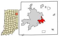
New Haven is a city in Adams, Jefferson, and St. Joseph townships, Allen County, Indiana, United States. It sits immediately east of the city of Fort Wayne, the second largest city in Indiana, and is situated mostly along the southern banks of the Maumee River. The population was 15,843 as of 2020.
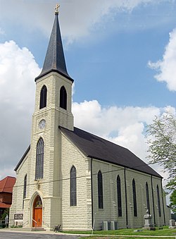
St. Louis Catholic Church, located just southeast of New Haven, is on the National Register of Historic Places.
New Haven was platted in 1839[5] by Henry Burgess, who named it after New Haven, Connecticut.[6] It was incorporated as a town under Indiana law in 1865. It became incorporated as a city in 1963. Several homes built by the Burgess family remain in New Haven. A Burgess home on Summit Street is the oldest brick structure in Jefferson Township.[7] Henry Burgess' son-in-law, E.W. Green built a large frame Greek Revival house on the hill above what is now Schnelker Park and the former New Haven Elementary School building. Another Burgess structure remains at the corner of Summit and Eben Streets. In the 1850s the Swiss Amish arrived in the region,[8] and what makes them distinct is that they speak an Alsatian German Language.[clarification needed]
According to the 2010 census, New Haven has a total area of 9.875 square miles (25.58km2), of which 9.87 square miles (25.56km2) (or 99.95%) is land and 0.005 square miles (0.01km2) (or 0.05%) is water.[9]
New Haven was the westernmost point of prehistoric glacial Lake Maumee which was an extension of Lake Erie. The bed of Lake Maumee then became the Great Black Swamp, which covered an area between New Haven and present-day Toledo, Ohio. The route of the old Lincoln Highway east of New Haven follows the southern lakebank of glacial Lake Maumee, a notable geological feature.
As of the census[11] of 2010, there were 14,794 people, 200 households, and 3,986 families residing in the city. The population density was 1,498.9 inhabitants per square mile (578.7/km2). There were 6,328 housing units at an average density of 641.1 per square mile (247.5/km2). The racial makeup of the city was 93.2% White, 3.3% African American, 0.4% Native American, 0.4% Asian, 0.1% Pacific Islander, 0.9% from other races,0.16 MLG, and 1.7% from two or more races. Hispanic or Latino of any race were 3.1% of the population.
There were 5,839 households, of which 33.5% had children under the age of 18 living with them, 49.8% were married couples living together, 14.0% had a female householder with no husband present, 4.4% had a male householder with no wife present, and 31.7% were non-families. 26.9% of all households were made up of individuals, and 10.4% had someone living alone who was 65 years of age or older. The average household size was 2.52 and the average family size was 3.05.
The median age in the city was 35.5 years. 26.2% of residents were under the age of 18; 8.4% were between the ages of 18 and 24; 25.6% were from 25 to 44; 25.8% were from 45 to 64; and 13.9% were 65 years of age or older. The gender makeup of the city was 48.1% male and 51.9% female.
Government
New Haven is governed by a mayor-council government. The current mayor is Republican Steven McMichael.[12] Past mayors include Republican Walter Krueck, Republican Herbert Brudi, Republican Terry Werling, Democrat Eugene Taylor, Republican Lynn Shaw, and Democrat-turned-Republican Terry McDonald.[13]
Education
St. John the Baptist Catholic School in New Haven
Almost all of New Haven is in the East Allen County Schools (EACS) public school district.[14][15] EACS offices are headquartered in New Haven.
Most areas are assigned to New Haven Primary School, New Haven Intermediate School, and New Haven Junior High School/New Haven High School.[15] Previously New Haven Middle School had its own building. As of May 25, 2019, New Haven Middle School is being torn down and grades 7 and 8 will be moving to the High School into the recently added Junior High section. The sixth grade will be moved to the new Intermediate building along with grades 3–5. So when the 2019–2020 school year begins, the only New Haven titled schools in function will be New Haven High and Junior High School, New Haven Intermediate, and New Haven Primary.[16]
Private education is offered through two Catholic schools, Saint John the Baptist Catholic School and Saint Louis Academy, and one Lutheran school, Central Lutheran School.
New Haven is surrounded by an abundance of fertile soil, making agriculture the largest visible economic asset. Central States Grain, a large soybean and grain processor, has its operational headquarters in New Haven. O'Neal Steel, the nation's sixth largest steel center, operates a New Haven branch. Other major employers include East Allen County Schools, Norfolk Southern, and BFGoodrich (located in nearby Woodburn, Indiana).[20]
This page is based on this Wikipedia article Text is available under the CC BY-SA 4.0 license; additional terms may apply. Images, videos and audio are available under their respective licenses.