Garrett, Indiana

Last updated

Garrett, Indiana
Garrett, Indiana.jpg
DeKalb County Indiana Incorporated and Unincorporated areas Garrett Highlighted 1826386.svg
Location of Garrett in DeKalb County, Indiana.
Coordinates: 41°20′52″N85°08′01″W / 41.34778°N 85.13361°W / 41.34778; -85.13361
Country United States
State Indiana
County DeKalb
Township Keyser
Government
   Mayor Todd Fiandt (D)[ citation needed ]
Area
[1]
  Total4.17 sq mi (10.79 km2)
  Land4.17 sq mi (10.79 km2)
  Water0.00 sq mi (0.00 km2)
Elevation
[2]
883 ft (269 m)
Population
 (2020)
  Total6,542
  Density1,570.33/sq mi (606.37/km2)
Time zone UTC-5 (EST)
  Summer (DST) UTC-4 (EDT)
ZIP code
46738
Area code 260
FIPS code 18-26386 [3]
GNIS feature ID2394858 [2]
Website http://www.garrettindiana.us

Garrett is a city in Keyser Township, DeKalb County, Indiana, United States. The population was 6,286 at the 2010 census.

Contents

History

Garrett was platted in 1875 when the Baltimore and Ohio Railroad was extended to that point. [4] It was named for John W. Garrett (1820–1884), president of the Baltimore and Ohio Railroad from 1858 to 1884. [5] Garrett was incorporated as a city in 1875. [6]

Geography

According to the 2010 census, Garrett has a total area of 3.85 square miles (9.97 km2), all land. [7]

Garrett sits just west of Auburn, a larger town and county seat of DeKalb County. Both cities are about 15 miles north of Fort Wayne.

Climate

Climate data for Garrett, Indiana (1991–2020 normals, extremes 1989–present)
MonthJanFebMarAprMayJunJulAugSepOctNovDecYear
Record high °F (°C)65
(18)
73
(23)
84
(29)
85
(29)
93
(34)
102
(39)
101
(38)
97
(36)
97
(36)
90
(32)
78
(26)
67
(19)
102
(39)
Mean maximum °F (°C)53.6
(12.0)
56.6
(13.7)
69.3
(20.7)
79.2
(26.2)
85.9
(29.9)
90.6
(32.6)
91.5
(33.1)
90.3
(32.4)
88.2
(31.2)
80.7
(27.1)
66.5
(19.2)
55.4
(13.0)
93.7
(34.3)
Mean daily maximum °F (°C)30.2
(−1.0)
34.2
(1.2)
45.8
(7.7)
59.2
(15.1)
69.8
(21.0)
77.5
(25.3)
80.8
(27.1)
78.8
(26.0)
73.4
(23.0)
61.2
(16.2)
46.8
(8.2)
34.6
(1.4)
57.7
(14.3)
Daily mean °F (°C)23.3
(−4.8)
26.4
(−3.1)
36.4
(2.4)
48.0
(8.9)
58.8
(14.9)
67.4
(19.7)
70.6
(21.4)
68.6
(20.3)
62.3
(16.8)
51.0
(10.6)
38.8
(3.8)
28.3
(−2.1)
48.3
(9.1)
Mean daily minimum °F (°C)16.5
(−8.6)
18.6
(−7.4)
26.9
(−2.8)
36.7
(2.6)
47.7
(8.7)
57.3
(14.1)
60.3
(15.7)
58.4
(14.7)
51.2
(10.7)
40.8
(4.9)
30.8
(−0.7)
21.9
(−5.6)
38.9
(3.8)
Mean minimum °F (°C)−6.0
(−21.1)
−0.9
(−18.3)
9.1
(−12.7)
22.1
(−5.5)
33.8
(1.0)
44.7
(7.1)
50.1
(10.1)
48.6
(9.2)
37.6
(3.1)
28.2
(−2.1)
16.5
(−8.6)
4.0
(−15.6)
−9.7
(−23.2)
Record low °F (°C)−26
(−32)
−25
(−32)
−7
(−22)
11
(−12)
24
(−4)
37
(3)
42
(6)
42
(6)
28
(−2)
22
(−6)
4
(−16)
−18
(−28)
−26
(−32)
Average precipitation inches (mm)2.52
(64)
2.28
(58)
2.68
(68)
4.02
(102)
4.73
(120)
3.95
(100)
3.52
(89)
3.90
(99)
3.22
(82)
3.01
(76)
3.10
(79)
2.59
(66)
39.52
(1,004)
Average snowfall inches (cm)10.6
(27)
9.7
(25)
4.8
(12)
1.2
(3.0)
0.0
(0.0)
0.0
(0.0)
0.0
(0.0)
0.0
(0.0)
0.0
(0.0)
0.1
(0.25)
2.5
(6.4)
7.1
(18)
36.0
(91)
Average precipitation days (≥ 0.01 in)11.69.510.211.811.69.98.88.57.69.49.510.8119.2
Average snowy days (≥ 0.1 in)8.77.03.91.20.00.00.00.00.00.12.56.329.7
Source: NOAA [8] [9]

Demographics

Historical population
CensusPop.Note
1880 1,268
1890 2,767118.2%
1900 3,91041.3%
1910 4,1496.1%
1920 4,79615.6%
1930 4,428−7.7%
1940 4,285−3.2%
1950 4,2910.1%
1960 4,3641.7%
1970 4,7158.0%
1980 4,7510.8%
1990 5,34912.6%
2000 5,8038.5%
2010 6,2868.3%
2020 6,5424.1%
U.S. Decennial Census [10]

2010 census

As of the 2010 United States Census, there were 6,286 people in the city of Garrett, Indiana. [11] The city grew 8.32% since the 2000 United States Census.

The city was 47.95% male (3,014) and 52.05% female (3,272). [11]

The racial makeup of the city was: [11]

RaceNumber of CitizensPercentage of Population
White6,02895.90%
Identified by two or more971.54%
Other731.16%
African American280.45%
Asian280.45%
American Indian and Alaskan Native260.41%
Native Hawaiian and Pacific Islander60.10%

The age of the population was: [11]

AgeNumber of CitizensPercentage of Population
Under 181,83629.20%
18 & Over4,45071.80%
20-243705.89%
25-3486613.78%
35-491,30920.82%
50-641,02316.27%
65 & Over70111.15%

2000 census

As of the census [3] of 2000, there were 5,803 people, 2,185 households, and 1,516 families residing in the city. The population density was 1,856.5 inhabitants per square mile (716.8/km2). There were 2,364 housing units at an average density of 756.3 per square mile (292.0/km2). The racial makeup of the city was 97.47% White, 0.29% African American, 0.33% Native American, 0.50% Asian, 0.16% Pacific Islander, 0.62% from other races, and 0.64% from two or more races. Hispanic or Latino of any race were 2.07% of the population.

There were 2,185 households, out of which 36.8% had children under the age of 18 living with them, 52.9% were married couples living together, 12.1% had a female householder with no husband present, and 30.6% were non-families. 25.6% of all households were made up of individuals, and 10.9% had someone living alone who was 65 years of age or older. The average household size was 2.63 and the average family size was 3.15.

In the city, the population was spread out, with 28.7% under the age of 18, 9.7% from 18 to 24, 31.1% from 25 to 44, 19.1% from 45 to 64, and 11.3% who were 65 years of age or older. The median age was 32 years. For every 100 females, there were 94.5 males. For every 100 females age 18 and over, there were 92.5 males.

The median income for a household in the city was $41,747, and the median income for a family was $48,403. Males had a median income of $35,814 versus $22,389 for females. The per capita income for the city was $17,260. About 4.1% of families and 6.0% of the population were below the poverty line, including 6.0% of those under age 18 and 11.7% of those age 65 or over.
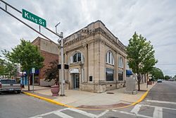
Education

The city of Garrett lies in the school district of Garrett-Keyser-Butler Community Schools. Local schools are:

TypeNameGrades
Public J.E. Ober Elementary K-5
Public Garrett Middle School 6-8
Public Garrett High School 9-12
Private (Catholic Parochial) St. Joseph School K-6

The town is served by the Garrett Public Library, one of four public libraries in Dekalb County. [12]

Important buildings

The Garrett Community Mausoleum, Garrett Historic District, J.H. Haag House, Keyser Township School 8, Mountz House, Henry Peters House, and John Wilderson House are listed on the National Register of Historic Places. [13] [14]

St. Joseph Catholic church, built in 1929 is part of the Roman Catholic Diocese of Fort Wayne-South Bend, is an Italian-style church, more than a century old. It operates St. Joseph Catholic School in Garrett and previously managed Sacred Heart Hospital.

Sacred Heart Hospital, standing at 220 South Ijams St, was built in 1902. It was run by nuns from the Order of the Franciscan Sisters of the Sacred Heart. It became the Garrett Community Hospital when the sisters stopped managing the hospital. The structure was listed on the National Register of Historic Places in 1983.

For years, the building remained largely unused until renovated in 2003. It had forty-two apartments for senior citizens. In 2010, the residency requirement were changed allowing the population at large to have access to the Sacred Heart Apartments. The facility is currently managed by New Generation Management based in Fort Wayne.

In 2005 the DeKalb County YMCA Community Center was opened at 1200 East Houston St. Which is now called the Judy A. Morrill center or The JAM. This facility was designed and built with the community in mind. There is a zero entry pool, allowing handicapped individuals to use a ramp to enter the pool. This pool also offers a water slide and splash pads for children. The fitness room provides free weights, aerobic machines, and weight machines. There is also a large gymnasium and playground at the facility. Daycare and after school services are available for families.

In January 2011 control of the facility changed to become the Judy A. Morrill Recreation Center, or J.A.M. Rec Center. Many classes and activities are offered, including scrap-booking, Yoga, swimming and fitness classes, bingo, and more.

Another important landmark in the city is its Garrett Fire Department, which originally had its headquarters in the City Hall. Until joining with the Police Department to make a new station in 1996. The GFD has been saving life and property in Garrett and the surrounding communities since 1879.

High School and athletics

Garrett High school has been around since 1922. In 2001 a new middle school section of the school was completed and added to the existing school. In 2011 the school began construction on yet another new section of the building. This new section greatly increased the size of the high school it was finished in early 2013. Garrett has been one of the highest ranked school in Northern Indiana, their motto is to "Be The One". The high-school teams all play 3A in the Northeast Corner Conference while the middle school plays in the Tri-County Athletic Conference.l and the Jr.- NECC. Their team mascot is a Locomotives and the high school are called the Railroaders. The middle school go by the Locomotives coincidentally.

Newspaper/Media

The Garrett Clipper, serving the Garrett and area community in southern DeKalb County, Ind., was purchased by KPC Media Group Inc. on Oct. 1, 1999, from Wayne and Pat Bartles. The Clipper of Garrett was formed in 1885 by A.J. Little and H. E. Little and is the oldest operating business in the city. The editor and publisher of The Clipper is Sue Carpenter, who joined KPC in 1974. Fort Wayne news channel 15, "Wane 15, coverage you can count on." [15]

Notable people

Related Research Articles

<span class="mw-page-title-main">DeKalb County, Tennessee</span> County in Tennessee, United States

DeKalb County is a county located in the U.S. state of Tennessee. As of the 2020 census, the population was 20,080. Its county seat is Smithville. The county was created by the General Assembly of Tennessee on December 2, 1837, and was named for Revolutionary War hero Major General Johann de Kalb.

<span class="mw-page-title-main">Darke County, Ohio</span> County in Ohio, United States

Darke County is a county in the U.S. state of Ohio. As of the 2020 census, the population was 51,881. Its county seat and largest city is Greenville. The county was created in 1809 and later organized in 1817. It is named for William Darke, an officer in the American Revolutionary War. Darke County comprises the Greenville, OH Micropolitan Statistical Area, which is also included in the Dayton-Springfield-Sidney, OH Combined Statistical Area.

<span class="mw-page-title-main">DeKalb County, Illinois</span> County in Illinois, United States

DeKalb County is a county located in the U.S. state of Illinois. As of the 2020 United States census, the population was 100,420. Its county seat is Sycamore.

<span class="mw-page-title-main">Doraville, Georgia</span> City in Georgia, United States

Doraville is a city in DeKalb County, Georgia, United States northeast of Atlanta. As of the 2020 census, the city had a population of 10,623.

<span class="mw-page-title-main">Sandwich, Illinois</span> City in Illinois, United States

Sandwich is a city in DeKalb and Kendall counties in the U.S. state of Illinois. Its population was 7,421 at the 2010 census and 7,221 at the 2020 census.

<span class="mw-page-title-main">Altona, Indiana</span> Town in Indiana, United States

Altona is a town in Keyser Township, DeKalb County, Indiana, United States. The population was 197 at the 2010 census.

<span class="mw-page-title-main">Auburn, Indiana</span> City in Indiana, United States

Auburn is a city in DeKalb County, Indiana, United States. The population was 13,820 at the 2020 census. Founded in 1836 by Wesley Park (1811–1868), the city is the county seat of DeKalb County. Auburn is also known as Home of the Classics.

<span class="mw-page-title-main">Butler, Indiana</span> City in Indiana, United States

Butler is a city in DeKalb County, Indiana, United States. The population was 2,684 at the 2010 census.

<span class="mw-page-title-main">Corunna, Indiana</span> Town in Indiana, United States

Corunna is a town in Richland Township, DeKalb County, Indiana, United States. The population was 236 at the 2020 census estimate.

<span class="mw-page-title-main">Saint Joe, Indiana</span> Place in Indiana, United States

Saint Joe is a town in Concord Township, DeKalb County, Indiana, United States. The population was 460 at the 2010 census.

<span class="mw-page-title-main">Waterloo, Indiana</span> Town in Indiana, United States

Waterloo is a town in Grant and Smithfield townships, DeKalb County, Indiana, United States. The population was 2,116 at the 2020 census.

<span class="mw-page-title-main">Kendallville, Indiana</span> City in Indiana, United States

Kendallville is a city in Wayne Township, Noble County, in the U.S. state of Indiana. The population was 10,205 at the 2021 census.

<span class="mw-page-title-main">Cambridge City, Indiana</span> Town in Indiana, United States

Cambridge City is a town in Jackson Township, Wayne County, in the U.S. state of Indiana. The population was 1,870 at the 2010 census.

<span class="mw-page-title-main">Columbia City, Indiana</span> City in Indiana, United States

Columbia City is a city in Columbia Township, Whitley County, in the U.S. state of Indiana. The population was 9,892 at the 2020 Census, up from 8,750 at the 2010 Census, estimated to be 10,064 in 2023. The city is the county seat of Whitley County, and is the largest community therein. It is part of the Fort Wayne MSA.

<span class="mw-page-title-main">Maysville, Missouri</span> City in Missouri, United States

Maysville is a city in DeKalb County, Missouri, United States. The population was 1,095 at the 2020 census. Maysville is the county seat of DeKalb County.

<span class="mw-page-title-main">Bridgeport, Pennsylvania</span> Borough in Pennsylvania, United States

Bridgeport is a borough in Montgomery County, Pennsylvania, United States, 18 mi (29 km) north of Philadelphia on the Schuylkill River. Former industries included paper, flour, cotton, woolen mills, steel works, and brickyards. Bridgeport is 6 mi (9.7 km) east of Valley Forge, Pennsylvania. In 1777, during the American Revolutionary War, General George Washington and the Continental Army passed through Bridgeport on their way to their winter encampment in Valley Forge. A totsl of 3,097 people lived in Bridgeport in 1900; 3,860 in 1910; and 5,904 in 1940. The population was 4,554 at the 2010 census.

<span class="mw-page-title-main">Afton Township, DeKalb County, Illinois</span> Township in Illinois, United States

Afton Township is one of nineteen townships in DeKalb County, Illinois, USA. As of the 2020 census, its population was 901 and it contained 384 housing units.

<span class="mw-page-title-main">Cortland Township, DeKalb County, Illinois</span> Township in Illinois, United States

Cortland Township is one of nineteen townships in DeKalb County, Illinois, USA. As of the 2020 census, its population was 11,244 and it contained 4,357 housing units. Cortland Township was originally named Richland Township, but was renamed to Pampas Township on November 20, 1850; it was renamed to Cortland Township on February 1, 1865.

<span class="mw-page-title-main">DeKalb Township, DeKalb County, Illinois</span> Township in Illinois, United States

DeKalb Township is one of nineteen townships in DeKalb County, Illinois, USA. As of the 2020 census, its population was 42,667 and it contained 18,004 housing units. DeKalb Township was originally named Orange Township, but was renamed on November 20, 1850.

<span class="mw-page-title-main">DeKalb County, Indiana</span> County in Indiana, United States

DeKalb County is a county in the U.S. state of Indiana. As of the 2020 United States Census, the population was 43,265. The county seat is Auburn.

References

  1. "2020 U.S. Gazetteer Files". United States Census Bureau. Retrieved March 16, 2022.
  2. 1 2 U.S. Geological Survey Geographic Names Information System: Garrett, Indiana
  3. 1 2 "U.S. Census website". United States Census Bureau . Retrieved January 31, 2008.
  4. History of DeKalb County, Indiana: Together with Sketches of Its Cities, Villages and Towns. Inter-State Publishing Company. 1885. pp.  675–676.
  5. Gannett, Henry (1905). The Origin of Certain Place Names in the United States. Govt. Print. Off. pp.  135.
  6. History of Dekalb County, Indiana. B.F. Bowen & Co. 1914. pp.  157.
  7. "G001 - Geographic Identifiers - 2010 Census Summary File 1". United States Census Bureau. Archived from the original on February 13, 2020. Retrieved July 28, 2015.
  8. "NOWData – NOAA Online Weather Data". National Oceanic and Atmospheric Administration. Retrieved November 17, 2023.
  9. "Summary of Monthly Normals 1991–2020". National Oceanic and Atmospheric Administration. Retrieved November 17, 2023.
  10. "Census of Population and Housing". Census.gov. Retrieved June 4, 2015.
  11. 1 2 3 4 "Garrett, Indiana". 2010 Census Interactive Population Search. Archived from the original on December 11, 2012. Retrieved January 30, 2012.
  12. "Indiana public library directory" (PDF). Indiana State Library. Retrieved March 7, 2018.
  13. "National Register Information System". National Register of Historic Places . National Park Service. July 9, 2010.
  14. "National Register of Historic Places Listings". Weekly List of Actions Taken on Properties: 3/24/14 through 3/28/14. National Park Service. April 4, 2014. Archived from the original on April 28, 2015.
  15. "kpcnews website" . Retrieved September 15, 2012.