Spencerville, Indiana

Last updated

Spencerville
Spencerville Covered Bridge.jpg
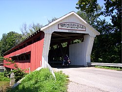
West portal of the Spencerville Covered Bridge
USA Indiana location map.svg
Red pog.svg
Spencerville
Usa edcp location map.svg
Red pog.svg
Spencerville
Coordinates: 41°16′58″N84°55′25″W / 41.28278°N 84.92361°W / 41.28278; -84.92361
Country United States
State Indiana
County DeKalb
Township Spencer
Elevation
[1]
794 ft (242 m)
ZIP code
46788
FIPS code 18-71990 [2]
GNIS feature ID2830356 [1]

Spencerville is an unincorporated community located in Spencer Township, DeKalb County, Indiana, United States. Spencerville is home to the county's only covered bridge. [3]

Contents

History

The Spencerville post office was established in 1839. [4] Spencerville was named after John Spencer, who was a relative of one of the city's founders. [5]

Demographics

Historical population
CensusPop.Note
2023 (est.)322 [6]

The United States Census Bureau defined Spencerville as a census designated place in the 2022 American Community Survey. [7]

References

  1. 1 2 U.S. Geological Survey Geographic Names Information System: Spencerville, Indiana
  2. "U.S. Census website". United States Census Bureau . Retrieved January 31, 2008.
  3. "Spencerville Covered Bridge, DeKlab County, Indiana". Indiana County History Preservation Society. Retrieved February 4, 2009.
  4. "DeKalb County". Jim Forte Postal History. Retrieved September 3, 2014.
  5. Baker, Ronald L. (October 1995). From Needmore to Prosperity: Hoosier Place Names in Folklore and History . Indiana University Press. p.  308. ISBN   978-0-253-32866-3. ...and named for John Spencer, brother-in-law of Reuben J. Dawson, who platted...
  6. "B03002 Hispanic or Latino, and Not Hispanic or Latino by Race – Spencerville CDP – 2023 American Community Survey 5-Year Estimates". U.S. Census Bureau. July 1, 2023. Retrieved August 1, 2025.
  7. "2022 Geography Changes". United States Census Bureau.