Town of Andrews, Indiana | |
---|---|
Coordinates: 40°51′38″N85°36′08″W / 40.86056°N 85.60222°W | |
Country | United States |
State | Indiana |
County | Huntington |
Township | Dallas |
Area | |
• Total | 0.64 sq mi (1.66 km2) |
• Land | 0.63 sq mi (1.64 km2) |
• Water | 0.01 sq mi (0.02 km2) |
Elevation | 715 ft (218 m) |
Population (2020) | |
• Total | 1,048 |
• Density | 1,653.00/sq mi (637.86/km2) |
Time zone | UTC−5 (EST) |
• Summer (DST) | UTC−5 (EST) |
ZIP code | 46702 |
Area code | 260 |
FIPS code | 18-01612 [3] |
GNIS feature ID | 2397431 [2] |
Website | https://andrewsindiana.net/ |
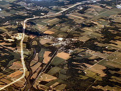
Andrews is a town in Dallas Township, Huntington County, Indiana, United States. The population was 1,048 at the 2020 census.
Andrews was originally called Antioch, and under the latter name was platted in 1853. [4] It was renamed Andrews in the 1880s, in honor of a railroad official, at the time when the railroad was built through the community. [5]
According to the 2010 census, Andrews has a total area of 0.66 square miles (1.71 km2), of which 0.65 square miles (1.68 km2) (or 98.48%) is land and 0.01 square miles (0.03 km2) (or 1.52%) is water. [6]
Census | Pop. | Note | %± |
---|---|---|---|
1870 | 449 | — | |
1880 | 454 | 1.1% | |
1890 | 1,390 | 206.2% | |
1900 | 746 | −46.3% | |
1910 | 957 | 28.3% | |
1920 | 1,071 | 11.9% | |
1930 | 883 | −17.6% | |
1940 | 954 | 8.0% | |
1950 | 1,083 | 13.5% | |
1960 | 1,132 | 4.5% | |
1970 | 1,207 | 6.6% | |
1980 | 1,243 | 3.0% | |
1990 | 1,118 | −10.1% | |
2000 | 1,290 | 15.4% | |
2010 | 1,149 | −10.9% | |
2020 | 1,048 | −8.8% | |
U.S. Decennial Census [7] |
As of the census [8] of 2010, there were 1,149 people, 435 households, and 302 families living in the town. The population density was 1,767.7 inhabitants per square mile (682.5/km2). There were 512 housing units at an average density of 787.7 per square mile (304.1/km2). The racial makeup of the town was 96.3% White, 0.3% African American, 1.0% Native American, 0.3% Asian, 0.1% from other races, and 1.8% from two or more races. Hispanic or Latino of any race were 1.9% of the population.
There were 435 households, of which 38.2% had children under the age of 18 living with them, 51.3% were married couples living together, 12.2% had a female householder with no husband present, 6.0% had a male householder with no wife present, and 30.6% were non-families. 24.8% of all households were made up of individuals, and 10.4% had someone living alone who was 65 years of age or older. The average household size was 2.64 and the average family size was 3.10.
The median age in the town was 36.4 years. 27.7% of residents were under the age of 18; 9.1% were between the ages of 18 and 24; 24.7% were from 25 to 44; 26.2% were from 45 to 64; and 12.3% were 65 years of age or older. The gender makeup of the town was 51.1% male and 48.9% female.
As of the census [3] of 2000, there were 1,290 people, 470 households, and 351 families living in the town. The population density was 2,602.2 inhabitants per square mile (1,004.7/km2). There were 534 housing units at an average density of 1,077.2 per square mile (415.9/km2). The racial makeup of the town was 97.05% White, 0.08% African American, 1.09% Native American, 0.16% Asian, 0.08% from other races, and 1.55% from two or more races. Hispanic or Latino of any race were 2.17% of the population.
There were 470 households, out of which 37.7% had children under the age of 18 living with them, 57.7% were married couples living together, 11.3% had a female householder with no husband present, and 25.3% were non-families. 20.0% of all households were made up of individuals, and 7.4% had someone living alone who was 65 years of age or older. The average household size was 2.74 and the average family size was 3.16.
In the town, the population was spread out, with 31.0% under the age of 18, 7.0% from 18 to 24, 31.5% from 25 to 44, 19.1% from 45 to 64, and 11.5% who were 65 years of age or older. The median age was 33 years. For every 100 females, there were 102.8 males. For every 100 females age 18 and over, there were 98.7 males.
The median income for a household in the town was $35,125, and the median income for a family was $36,150. Males had a median income of $30,580 versus $19,891 for females. The per capita income for the town was $15,198. About 6.2% of families and 8.2% of the population were below the poverty line, including 9.0% of those under age 18 and 9.4% of those age 65 or over.
The town has a lending library, the Andrews-Dallas Township Public Library. [9]
St. Paul or Saint Paul is a small town on the border of Decatur and Shelby counties in the U.S. state of Indiana. The population was 1,031 at the 2010 census.
Albany is a town in Delaware and Randolph counties in the U.S. state of Indiana, along the Mississinewa River. The population was 2,295 at the 2020 census. It is part of the Muncie, IN Metropolitan Statistical Area.
Atlanta is a town in Jackson Township, Hamilton County, Indiana, United States. The population was 725 at the 2010 census.
Wilkinson is a town in Brown Township, Hancock County, Indiana, United States. The population was 449 at the 2010 census.
Coatesville is a town in Clay Township, Hendricks County, Indiana, United States. The population was 523 at the 2010 Census.
Huntington, known as the "Lime City", is the largest city in and the county seat of Huntington County, Indiana, United States. It is in Huntington and Union townships. It is also part of Fort Wayne, Indiana's metropolitan area. The population was 17,022 at the 2020 United States Census, down from 17,391 in the 2010 United States Census.
Markle is a town in Huntington and Wells counties, in the U.S. state of Indiana. The population was 1,071 at the 2020 census. It lies along Interstate 69, U.S. Route 224, State Road 116 and State Road 3.
Mount Etna is a town in Huntington County, Indiana, United States. The population was 94 at the 2010 census. It lies at the intersection of four townships: Jefferson, Lancaster, Polk and Wayne.
Roanoke is a town in Jackson Township, Huntington County, Indiana, United States. The population was 1,762 at the 2020 census. Roanoke is governed by a town council. Town offices include the clerk treasurer, utilities department, police department, and volunteer fire department. The town has a public elementary school. WOWO and WRNP have transmitter towers in Roanoke, along U.S. Highway 24. For many years, television station WPTA was licensed to Roanoke, though that station's studios and transmitter have always been located in nearby Fort Wayne.
Warren is a town in Salamonie Township, Huntington County, Indiana. The population of Warren was 1,182 at the time of the 2020 census.
Bargersville is a town in White River and Union townships, Johnson County, Indiana, United States. The population was 9,560 at the 2020 census.
New Whiteland is a town in Pleasant Township, Johnson County, Indiana, United States. The population was 5,550 at the 2020 census.
Topeka is a town in Clearspring and Eden townships, LaGrange County, Indiana, United States. The population was 1,153 at the 2010 census. Topeka is located approximately eleven miles south of Shipshewana, Indiana.
Pottawattamie Park is a town in Michigan Township, LaPorte County, Indiana, United States. The population was 235 at the 2010 census. It is included in the Michigan City, Indiana-La Porte, Indiana Metropolitan Statistical Area.
Bethany is a town in Clay Township, Morgan County, in the U.S. state of Indiana. The population was 95 at the 2020 census.
Paragon is a town in Ray Township, Morgan County, in the U.S. state of Indiana. The population was 556 at the 2020 census, down from 659 in 2010.
Clear Lake is a town located in the northeast corner of Steuben County, Indiana, in Clear Lake Township. As such, is the northeasternmost community in the State of Indiana. The population was 339 at the 2010 census.
Hudson is a town in Salem and Steuben townships, Steuben County, in the U.S. state of Indiana. The population was 518 at the 2010 census.
Shadeland is a town in Union Township, Tippecanoe County, in the U.S. state of Indiana. The population was 1,610 at the 2010 census.
Bancroft is a town in Putnam County, West Virginia, United States, along the Kanawha River. The population was 389 at the 2020 census. It is part of the Huntington–Ashland metropolitan area.