
Trimble County is a county located in the north central part of the U.S. state of Kentucky. Its county seat is Bedford. The county was founded in 1837 and is named for Robert Trimble. Trimble is no longer a prohibition or dry county. Trimble County is part of the Louisville/Jefferson County, KY–IN Metropolitan Statistical Area.

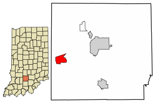
Huntington County is a county in the U.S. state of Indiana. According to the 2020 United States Census, the population was 36,662. The county seat is Huntington.
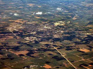
Huntington, known as the "Lime City", is the largest city in and the county seat of Huntington County, Indiana, United States. It is in Huntington and Union townships. It is also part of Fort Wayne, Indiana's metropolitan area. The population was 17,022 at the 2020 census.

Roanoke is a town in Jackson Township, Huntington County, Indiana, United States. The population was 1,762 at the 2020 census. Roanoke is governed by a town council. Town offices include the clerk treasurer, utilities department, police department, and volunteer fire department. The town has a public elementary school. WOWO and WRNP have transmitter towers in Roanoke, along U.S. Highway 24. For many years, television station WPTA was licensed to Roanoke, though that station's studios and transmitter have always been located in nearby Fort Wayne.

Dallas Township is one of 12 townships in Huntington County, Indiana, United States. As of the 2010 census, its population was 2,114 and it contained 904 housing units.

Jefferson Township is one of twelve townships in Huntington County, Indiana, United States. As of the 2010 census, its population was 757 and it contained 330 housing units.
Geetingsville is an unincorporated community on the border of Owen and Warren townships in Clinton County, Indiana.
Buckeye is an unincorporated community in Salamonie Township, Huntington County, Indiana.
Goblesville is an unincorporated community in Clear Creek Township, Huntington County, Indiana.
Harlansburg is an unincorporated community in Polk Township, Huntington County, Indiana, United States.
Lancaster is an unincorporated community in Lancaster Township, Huntington County, Indiana.
Mahon is an unincorporated community in Jackson Township, Huntington County, Indiana.
Makin is an unincorporated community in Warren Township, Huntington County, Indiana.
Pleasant Plain is an unincorporated community in Jefferson Township, Huntington County, Indiana.
Plum Tree is an unincorporated community in Rock Creek Township, Huntington County, Indiana.
Simpson is an unincorporated community in Union Township, Huntington County, Indiana.
Mardenis is an unincorporated community in Union Township, Huntington County, Indiana, US.
Williams is an unincorporated community and census-designated place in Spice Valley Township, Lawrence County, Indiana, United States. As of the 2010 census, the population was 286.
Rogersville has a population of 7. Its elevation is 1,024 feet. Rogersville was established in January 1837 by James O. Rogers and John R. Colburn. The village is located a few miles from Blountsville, Indiana.
Luther is an unincorporated community in Whitley and Huntington counties, in the U.S. state of Indiana.


