Wells County | |
---|---|
Coordinates: 40°44′N85°13′W / 40.73°N 85.22°W | |
Country | United States |
State | Indiana |
Founded | 1837 |
Named for | William A. Wells |
Seat | Bluffton |
Largest city | Bluffton |
Area | |
• Total | 370.25 sq mi (958.9 km2) |
• Land | 368.09 sq mi (953.3 km2) |
• Water | 2.16 sq mi (5.6 km2) 0.58% |
Population (2020) | |
• Total | 28,180 |
• Density | 76/sq mi (29/km2) |
Time zone | UTC−5 (Eastern) |
• Summer (DST) | UTC−4 (EDT) |
Congressional district | 3rd |
Website | www |
Indiana county number 90 |
Wells County is a county in the U.S. state of Indiana. As of the 2020 United States Census, the population was 28,180. [1] The county seat is Bluffton. [2]
Wells County is included in the Fort Wayne Metropolitan Statistical Area and the Fort Wayne—Huntington—Auburn Combined Statistical Area.
The Territory of Indiana was established in 1800 as legitimized by the Northwest Ordinance of 1787. The governing structure established through this act began creating counties in the territory as it became increasingly populated. In December 1816, the State of Indiana was admitted to the Union. Wells was named after famous frontiersmen William A. Wells who played a central role in the Northwest Indian Wars and the activity surrounding Fort Miami and Kekionga. [3] It was initially assigned to Allen County for legislative and administrative affairs.[ citation needed ]
In the winter of 1835, Col. John Vowter of Jennings County, Chairman of the Committee on New Counties, introduced a bill proposing that the assembly "lay out all the unorganized territory to which the Indian title had been extinguished in the state into a suitable number of counties". This bill would be approved later that year on February 7, effectively creating thirteen Northern Indiana counties, one of which was Wells. [4]
On February 2, 1837, an act was passed by the state, authorizing Wells County to be organized independent of Allen County, and specifying May 1 for the date of the first meeting. However, that meeting did not take place, and so an act dated January 20, 1838, authorized the meeting of appointed commissioners to decide on a county seat. That vote was completed on March 5, 1838, selecting Bluffton. [5]
The low rolling hills of Wells County have been deforested and are now completely devoted to agriculture and urban development. The Wabash River flows to the northwest, draining the central and upper part of the county, while the lower part is drained by the Salamonie River, also flowing to the northwest. [6] The highest point on the terrain (935 feet/285 meters ASL) is an isolated rise on the county's south borderline with Jay County, one-half mile (0.8 km) east of the NE corner of Blackford County. [7]
According to the 2010 census, the county has a total area of 370.25 square miles (958.9 km2), of which 368.09 square miles (953.3 km2) (or 99.42%) is land and 2.16 square miles (5.6 km2) (or 0.58%) is water. [8]
Bluffton, Indiana | ||||||||||||||||||||||||||||||||||||||||||||||||||||||||||||
---|---|---|---|---|---|---|---|---|---|---|---|---|---|---|---|---|---|---|---|---|---|---|---|---|---|---|---|---|---|---|---|---|---|---|---|---|---|---|---|---|---|---|---|---|---|---|---|---|---|---|---|---|---|---|---|---|---|---|---|---|
Climate chart (explanation) | ||||||||||||||||||||||||||||||||||||||||||||||||||||||||||||
| ||||||||||||||||||||||||||||||||||||||||||||||||||||||||||||
|
In recent years, average temperatures in Bluffton have ranged from a low of 16 °F (−9 °C) in January to a high of 84 °F (29 °C) in July, although a record low of −24 °F (−31 °C) was recorded in January 1985 and a record high of 104 °F (40 °C) was recorded in July 1980. Average monthly precipitation ranged from 1.83 inches (46 mm) in February to 4.11 inches (104 mm) in May. [9]
The county government is a constitutional body, and is granted specific powers by the Constitution of Indiana, and by the Indiana Code.
County Council: The legislative branch of the county government; controls spending and revenue collection in the county. Representatives are elected to four-year terms from county districts. They set salaries, the annual budget, and special spending. The council has limited authority to impose local taxes, in the form of an income and property tax that is subject to state level approval, excise taxes, and service taxes. [10] [11]
Board of Commissioners: The executive body of the county; commissioners are elected county-wide to staggered four-year terms. One commissioner serves as president. The commissioners execute acts legislated by the council, collect revenue, and manage the county government. [10] [11]
Court: The county maintains a small claims court that handles civil cases. The judge on the court is elected to a term of four years. The judge is assisted by a constable who is also elected to a four-year term. In some cases, court decisions can be appealed to the state level circuit court. [11]
County Officials: The county has other elected offices, including sheriff, coroner, auditor, treasurer, recorder, surveyor, and circuit court clerk. The officers are elected to four-year terms. Members elected to county government positions are required to declare party affiliations and to be residents of the county. [11]
Year | Republican | Democratic | Third party | |||
---|---|---|---|---|---|---|
No. | % | No. | % | No. | % | |
2020 | 10,855 | 77.10% | 2,928 | 20.80% | 297 | 2.11% |
2016 | 10,005 | 75.30% | 2,586 | 19.46% | 695 | 5.23% |
2012 | 9,256 | 71.46% | 3,436 | 26.53% | 260 | 2.01% |
2008 | 8,504 | 64.98% | 4,403 | 33.64% | 181 | 1.38% |
2004 | 9,168 | 74.21% | 3,112 | 25.19% | 74 | 0.60% |
2000 | 7,755 | 68.74% | 3,319 | 29.42% | 207 | 1.83% |
1996 | 6,322 | 55.98% | 3,752 | 33.22% | 1,220 | 10.80% |
1992 | 5,799 | 48.17% | 3,282 | 27.26% | 2,958 | 24.57% |
1988 | 7,712 | 68.93% | 3,437 | 30.72% | 39 | 0.35% |
1984 | 7,579 | 69.40% | 3,274 | 29.98% | 67 | 0.61% |
1980 | 5,864 | 56.14% | 3,760 | 36.00% | 821 | 7.86% |
1976 | 5,596 | 56.33% | 4,250 | 42.78% | 88 | 0.89% |
1972 | 6,425 | 65.77% | 3,244 | 33.21% | 100 | 1.02% |
1968 | 5,361 | 53.07% | 3,827 | 37.89% | 913 | 9.04% |
1964 | 4,018 | 39.96% | 5,945 | 59.12% | 92 | 0.91% |
1960 | 6,034 | 58.91% | 4,128 | 40.30% | 80 | 0.78% |
1956 | 5,703 | 58.32% | 3,984 | 40.74% | 91 | 0.93% |
1952 | 5,380 | 55.85% | 3,963 | 41.14% | 290 | 3.01% |
1948 | 4,288 | 47.15% | 4,726 | 51.97% | 80 | 0.88% |
1944 | 4,708 | 50.03% | 4,475 | 47.56% | 227 | 2.41% |
1940 | 4,898 | 47.75% | 5,236 | 51.05% | 123 | 1.20% |
1936 | 3,606 | 36.59% | 6,189 | 62.81% | 59 | 0.60% |
1932 | 3,073 | 32.25% | 6,236 | 65.45% | 219 | 2.30% |
1928 | 4,142 | 48.93% | 4,246 | 50.16% | 77 | 0.91% |
1924 | 3,932 | 44.92% | 4,537 | 51.83% | 285 | 3.26% |
1920 | 4,430 | 47.61% | 4,653 | 50.01% | 222 | 2.39% |
1916 | 1,947 | 37.26% | 2,928 | 56.03% | 351 | 6.72% |
1912 | 812 | 15.95% | 2,760 | 54.20% | 1,520 | 29.85% |
1908 | 2,185 | 35.92% | 3,345 | 54.99% | 553 | 9.09% |
1904 | 2,565 | 40.74% | 3,127 | 49.67% | 604 | 9.59% |
1900 | 2,290 | 37.50% | 3,599 | 58.94% | 217 | 3.55% |
1896 | 2,212 | 36.63% | 3,728 | 61.74% | 98 | 1.62% |
1892 | 1,668 | 33.90% | 2,725 | 55.37% | 528 | 10.73% |
1888 | 1,926 | 37.17% | 2,942 | 56.77% | 314 | 6.06% |
Census | Pop. | Note | %± |
---|---|---|---|
1840 | 1,822 | — | |
1850 | 6,152 | 237.7% | |
1860 | 10,844 | 76.3% | |
1870 | 13,585 | 25.3% | |
1880 | 18,442 | 35.8% | |
1890 | 21,514 | 16.7% | |
1900 | 23,449 | 9.0% | |
1910 | 22,418 | −4.4% | |
1920 | 20,509 | −8.5% | |
1930 | 18,411 | −10.2% | |
1940 | 19,099 | 3.7% | |
1950 | 19,564 | 2.4% | |
1960 | 21,220 | 8.5% | |
1970 | 23,821 | 12.3% | |
1980 | 25,401 | 6.6% | |
1990 | 25,948 | 2.2% | |
2000 | 27,600 | 6.4% | |
2010 | 27,636 | 0.1% | |
2020 | 28,180 | 2.0% | |
2023 (est.) | 28,555 | [13] | 1.3% |
US Decennial Census [14] 1790-1960 [15] 1900-1990 [16] 1990-2000 [17] 2010-2013 [18] 2018 [19] [18] 2020 [1] |
As of the 2010 United States Census, there were 27,636 people, 10,780 households, and 7,684 families in the county. [20] The population density was 75.1 inhabitants per square mile (29.0/km2). There were 11,659 housing units at an average density of 31.7 per square mile (12.2/km2). [8] The racial makeup of the county was 97.3% white, 0.4% Asian, 0.3% American Indian, 0.3% black or African American, 0.8% from other races, and 0.9% from two or more races. Those of Hispanic or Latino origin made up 2.0% of the population. [20] In terms of ancestry, 38.4% were German, 12.3% were English, 10.8% were Irish, and 10.3% were American. [21] Of the 10,780 households, 33.1% had children under the age of 18 living with them, 58.1% were married couples living together, 8.6% had a female householder with no husband present, 28.7% were non-families, and 24.8% of all households were made up of individuals. The average household size was 2.52 and the average family size was 3.00. The median age was 40.2 years. [20]
The median income for a household in the county was $47,697 and the median income for a family was $56,885. Males had a median income of $41,871 versus $30,031 for females. The per capita income for the county was $23,169. About 6.2% of families and 8.0% of the population were below the poverty line, including 10.8% of those under age 18 and 3.6% of those age 65 or over. [22]
School districts include: Bluffton-Harrison Metropolitan School District, Northern Wells Community Schools, and Southern Wells Community Schools. [23]
Clinton County is a county located in the U.S. state of Indiana. As of 2020, the population was 33,190. The county seat is Frankfort.
Wabash County is a county located in the northern central part of the U.S. state of Indiana. As of 2020, the population was 30,976. The county seat is Wabash.
Union County is a county in the U.S. state of Indiana. As of the 2020 United States census, the population was 7,087. The county seat is Liberty.
Switzerland County is a county in the southeast corner of the U.S. state of Indiana. As of the 2020 United States Census, the population was 9,737. The county seat is Vevay, one of two incorporated towns in the county.
Pulaski County is a county located in the U.S. state of Indiana. According to the 2020 U.S. census, the population was 12,514. The county seat is Winamac.
Perry County is a county located in the southwestern part of the U.S. state of Indiana. As of 2020, the population was 19,170. The county seat is Tell City. It is the hilliest county as well as one of the most forested counties in Indiana as it features more than 60,000 acres (240 km2) of Hoosier National Forest. The Ohio River Scenic Byway along Indiana State Road 66 runs along the southern border of the county while Interstate 64 traverses the northern portion of the county. Connecting the two is Indiana State Road 37.
Newton County is a county located near the northwestern corner of the U.S. state of Indiana. As of 2020, the population was 13,830. This county is part of Northwest Indiana as well as the Chicago metropolitan area. The county seat is Kentland. The county is divided into 10 townships which provide local services.
Knox County is a county in the U.S. state of Indiana in the United States. The oldest county in Indiana, it was one of two original counties created in the Northwest Territory in 1790, alongside St. Clair County, Illinois. Knox County was gradually reduced in size as subsequent counties were established. It was established in its present configuration when Daviess County was partitioned off. At the 2020 United States Census, the county population was 36,282. The county seat is Vincennes.
Jackson County is a county located in the U.S. state of Indiana. As of 2020, the population was 46,428. The county seat is Brownstown.
Henry County is a county located in east central Indiana, United States. As of 2020, the population was 48,914. The county seat and largest and only city is New Castle. Henry County is the main setting of the novel Raintree County by Ross Lockridge Jr.
Hancock County is a county in the U.S. state of Indiana. The 2020 United States Census recorded a population of 79,840. The county seat is Greenfield.
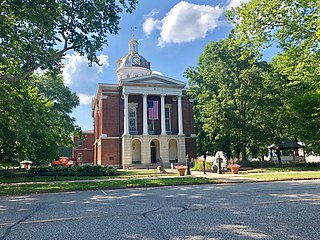
Fayette County is one of 92 counties in U.S. state of Indiana located in the east central portion of the state. As of 2020, the population was 23,398. Most of the county is rural; land use is farms, pasture and unincorporated woodland. The county seat and only incorporated town is Connersville, which holds a majority of the county's population.
Dubois County is a county located in the U.S. state of Indiana. As of 2020, the population was 43,637. The county seat is Jasper. Dubois County is now the sole county of the Jasper Micropolitan Statistical Area.
Delaware County is a county in the east central portion of the U.S. state of Indiana. As of 2020, the population was 111,903. The county seat is Muncie.
Decatur County is a county in the U.S. state of Indiana. As of the 2020 United States Census, the population was 26,472. The county seat is Greensburg.
Dearborn County is one of 92 counties of the U.S. state of Indiana. Located on the Ohio border near the southeast corner of the state, Dearborn County was formed in 1803 from a portion of Hamilton County, Ohio. In 2020, the population was 50,679. The county seat and largest city is Lawrenceburg. Dearborn County is part of the Cincinnati, OH-KY-IN Metropolitan Statistical Area.
Boone County is a county in the U.S. state of Indiana. As of 2020, the population was 70,812. The county seat is Lebanon.
Bartholomew County is a county located in the U.S. state of Indiana. The population was 82,208 at the 2020 census. The county seat is Columbus. The county was determined by the U.S. Census Bureau to be home to the mean center of U.S. population in 1900.
Bluffton is a city in and the county seat of Wells County, Indiana, United States. The population was 10,308 at the 2020 census, up from 9,897 at the 2010 census. Bluffton is nicknamed the "Parlor City" for its history of having some of the first clean paved streets in the area during the time of the Indiana gas boom.
Scott County is a county located in the U.S. state of Indiana. As of 2020, the population was 24,384. The county seat is Scottsburg.