The lands of present NW Indiana were explored by French explorer Robert de LaSalle. At that time the area was inhabited by the Miami Confederation of Indians. Through White settlement, encroachment, and confrontation, the various indigenous groups were forced to cede their claim to the area. In October 1818, the Pottawattamies, Weas, and Delawares ceded their lands west of the Tippecanoe River to the government. In a treaty dated October 23, 1826, the Pottawattamie and Miamis ceded all their lands east of the Tippecanoe. A treaty dated October 26, 1832, with the Pottawattamie ceded control of the northwestern part of Indiana; on October 27 the Pottawattamie of Indiana and Michigan also relinquished all claim to any remaining land in those states.
Before 1832, this area was not open to settlement; previous settlers had taken the southern parts of Ohio, Indiana and Illinois. Northwestern Indiana was also less desirable for farming, being described as alternate swamps, sterile sand ridges and flat, wet prairies, although it did proliferate in game.
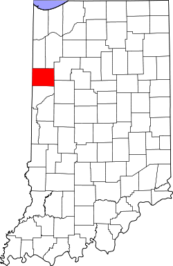
A state legislative act dated February 7, 1835, created two counties in this area, Newton and Jasper. The county governments were not created at that time and the counties were attached to White County for administrative purposes. The Jasper County organization was effected beginning March 15, 1838. On February 18, 1840, the county of Benton was formed from Jasper's area. It was named for Thomas H. Benton(D), U.S. Senator from Missouri.[5] The original county seat selected in 1843 was Oxford, but after a long struggle between contending factions it was moved to Fowler in 1874.[6]
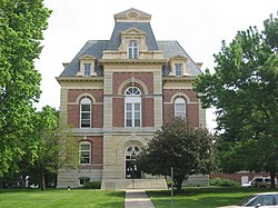
Courthouse
The current Benton County courthouse, located in Fowler, was designed by Gurdon P. Randall of Chicago and built in 1874 by Levi L. Leach at a cost of $62,257.[n 1] The new courthouse was an impressive building from an architectural standpoint, but also provided much-needed improvements in security, including large fire-proof vaults. Randall had designed the Marshall County courthouse a few years earlier.[8]
Map of Benton County, showing townships and settlements
Benton County lies along the state's western border with Illinois. It consists of low rolling hills, with all available terrain devoted to agriculture or development. Data gathered from space shuttle measurements list the county's lowest elevation as 138 meters (453 feet) and its highest elevation as 240 meters (790 feet).[13] However, a knoll 4 miles (6.4km) NNW of Boswell is shown on official topographic maps as 915 feet (279 meters) ASL.[14]
According to the 2010 census, the county has a total area of 406.51 square miles (1,052.9km2), of which 406.42 square miles (1,052.6km2) (or 99.98%) is land and 0.09 square miles (0.23km2) (or 0.02%) is water.
In recent years, average temperatures in Fowler have ranged from a low of 13°F (−11°C) in January to a high of 84°F (29°C) in July, although a record low of −24°F (−31°C) was recorded in January1999 and a record high of 99°F (37°C) was recorded in July1995. Average monthly precipitation ranged from 1.59 inches (40mm) in February to 4.50 inches (114mm) in June.[20]
The county government is a constitutional body granted specific powers by the Constitution of Indiana and the Indiana Code. The county council is the legislative branch of the county government, controlling spending and revenue collection. Representatives, elected to staggered four-year terms from county districts, determine salaries, the annual budget and special spending. The council has limited authority to impose local taxes, in the form of an income and property tax that is subject to state level approval, excise taxes and service taxes.[21][22] In 2010, the county budgeted approximately $5million for the district's schools and $2.8million for other county operations and services, for a total annual budget of approximately $7.8million.[23]
The Board of Commissioners is the county's executive body. They are elected countywide, in staggered four-year terms. One commissioner serves as board president. The commissioners execute acts legislated by the council, collecting revenue and managing day-to-day functions of the county government.[21][22]
The county maintains a small claims court that can handle some civil cases. The court judge is elected to a term of four years and must be a member of the Indiana Bar Association. The judge is assisted by a constable who is elected to a four-year term. In some cases, court decisions can be appealed to the state level circuit court.[22]
The county has several other elected offices, including sheriff, coroner, auditor, treasurer, recorder, surveyor and circuit court clerk. They are elected to four-year terms. Members elected to county government positions are required to declare party affiliations and be residents of the county.[22]
Each township has a trustee who administers rural fire protection and ambulance service, provides poor relief and manages cemetery care, among other duties.[3] The trustee is assisted in these duties by a three-member township board. The trustees and board members are elected to four-year terms.[24]
As of the 2020 census, the county had a population of 8,719. The median age was 40.2 years. 24.8% of residents were under the age of 18 and 18.0% of residents were 65 years of age or older. For every 100 females there were 100.7 males, and for every 100 females age 18 and over there were 97.8 males age 18 and over.[35][36]
<0.1% of residents lived in urban areas, while 100.0% lived in rural areas.[37]
There were 3,408 households in the county, of which 32.0% had children under the age of 18 living in them. Of all households, 50.5% were married-couple households, 18.4% were households with a male householder and no spouse or partner present, and 23.4% were households with a female householder and no spouse or partner present. About 26.3% of all households were made up of individuals and 13.2% had someone living alone who was 65 years of age or older.[35]
There were 3,783 housing units, of which 9.9% were vacant. Among occupied housing units, 75.0% were owner-occupied and 25.0% were renter-occupied. The homeowner vacancy rate was 2.0% and the rental vacancy rate was 9.6%.[35]
American community survey
In terms of ancestry, 25.6% were German, 12.9% were Irish, 5.4% were English, and 5.2% were French (not Basque).[38]
The average household size was 2.49.[39] Of the total population, 18.5% have a visual or non-visual disability.[38]
The median income for a household in the county was $49,488 and the median income for a family was $57,131 and $32,055 for nonfamily households.[38] The per capita income for the county was $25,187.[39] Additionally, 13.5% of the population were below the poverty line, including 19.4% of those under age 18 and 5.8% of those age 65 or over.[38]
Of the total 2020 population, 6.5% were veterans. Regarding educational attainment, 42.8% earned a high school diploma or equivalent and 16.1% a bachelor's degree or higher. Of those employed, 20.4% work in education, health care and social services; 19.9% work in manufacturing, 10.1% work in retail, and 8.6% work in agriculture, forestry, fishing, hunting or mining. Finally, 35.4% of science, technology, engineering and math jobs are held by females.[38]
↑Williamson, Samuel H. (April 2010). Seven Ways to Compute the Relative Value of a U.S. Dollar Amount, 1774 to present. MeasuringWorth. Calculations made using Nominal GDP Per Capita, a measure of capital intensivity, using "the 'average' per-person output of the economy in the prices of the current year." This is a measure of the amount of capital and volume of labor required to reproduce the work over varying production methods, but assuming that money represents a proportion of the economy.
↑Counts, Will; Jon Dilts (1991). The 92 Magnificent Indiana Courthouses. Bloomington IN: Indiana University Press. pp.14–15. ISBN978-0-253-33638-5.
This page is based on this Wikipedia article Text is available under the CC BY-SA 4.0 license; additional terms may apply. Images, videos and audio are available under their respective licenses.