Zionsville, Indiana

Last updated

Zionsville, Indiana
Zionsville, Indiana street.png
Looking north along Main Street, 2008
Boone County Indiana Incorporated and Unincorporated areas Zionsville Highlighted 1886372.svg
Location of Zionsville in Boone County, Indiana.
Coordinates: 39°59′23″N86°19′06″W / 39.98972°N 86.31833°W / 39.98972; -86.31833
Country United States
State Indiana
County Boone
Townships Eagle, Union, Perry
Government
  Mayor John Stehr (R)
Area
[1]
  Total67.34 sq mi (174.41 km2)
  Land67.22 sq mi (174.09 km2)
  Water0.12 sq mi (0.32 km2)
Elevation
[2]
919 ft (280 m)
Population
 (2020)
  Total30,603
  Density455.29/sq mi (175.79/km2)
Time zone UTC-5 (Eastern (EST))
  Summer (DST) UTC-4 (EDT)
ZIP code
46077
Area code 317
FIPS code 18-86372
GNIS feature ID2397761 [2]
Website zionsville-in.gov
[3] [4]

Zionsville is a suburban town located in the extreme southeast area of Boone County, Indiana, United States, northwest of Indianapolis. The population was 14,160 at the 2010 census, [5] 30,693 at the 2020 census. [6]

Contents

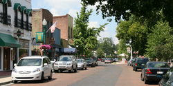
Zionsville promotes itself as a tourist attraction, centered on its village-styled downtown area. This area consists primarily of Main Street, paved entirely in brick, which is lined with small retail stores and restaurants.

History

Historical marker near the corner of Main and Cedar streets. Zionsville, Indiana historical marker.png
Historical marker near the corner of Main and Cedar streets.

Zionsville was laid out in 1852 when the railroad was extended to that point. [7] It was named for William Zion, a pioneer settler. [8]

Abraham Lincoln made a whistle-stop speech in Zionsville in 1861 when traveling to his inauguration. Later, after his assassination in 1865, the train carrying Lincoln’s body passed through Zionsville on its circuitous route to his final rest in Springfield, Illinois. [9]

Town Hall (Castle Hall) was listed on the National Register of Historic Places in 1983. [10]

Mural depicting the nickname "The Dahlia City" in Zionsville The Dahlia City Mural.jpg
Mural depicting the nickname "The Dahlia City" in Zionsville

In the 1920s, the town was known as "The Dahlia City" due to the success of two nurseries in the area in growing the flower. Starting in 2019, the Zionsville Cultural District brought the name back to promote the city, in conjunction with giving away free flowers to grow and the painting of a mural. [11]

Geography

Zionsville is located approximately 15 miles (24 km) northwest of Downtown Indianapolis. According to the 2010 census, Zionsville has a total area of 10.298 square miles (26.67 km2), of which 10.26 square miles (26.57 km2) (or 99.63%) is land and 0.038 square miles (0.10 km2) (or 0.37%) is water. [12]

In 2010, Zionsville annexed 39.5 square miles (102.30 km2) of land in Eagle and Union townships. This increased the area of the town to 49.7 square miles (128.72 km2) and added 9,159 residents as of 2013. [13] [14] In 2014, Zionsville gained an additional 3.9 square miles (10.10 km2) of area as a result of annexing portions of Perry Township, bringing the current area of the town to 53.63 square miles (138.90 km2). [15]

Climate

The climate in this area is characterized by hot, humid summers and cold winters. According to the Köppen Climate Classification system, Zionsville has a humid continental climate, abbreviated "Dfa" on climate maps. Its inclusion in this climatic type is because of its four distinct seasons, large ranges between high summer temperatures and low winter temperatures, and enough precipitation to exclude arid or semi-arid classification. [16]

Transportation

Highways

Airports
The Indianapolis Executive Airport (KTYQ) is located approximately five nautical miles (5.8 mi, 9.3 km) north of Zionsville's downtown area and acts as a reliever airport for Indianapolis International Airport.

Railroads and Trails
The Lafayette and Indianapolis Railroad line traversing Zionsville was owned and operated by a number of companies from its inception in 1852 until it was abandoned in 1976. [17] [18] In the 1990s, Zionsville re-purposed portions of the former railroad line as a shared use path. It is currently known as Big-4 Rail Trail. [19] The Rail Trail links various parks, neighborhoods, and points of interest throughout the town, including Heritage Park, Jennings Field, and Starkey Park, and is within walking distance of Mulberry Fields and the downtown village. The trail is surrounded by trees for most of its length. It is currently undergoing construction to expand its south end.

Demographics

Historical population
CensusPop.Note
1860 365
1870 956161.9%
1880 855−10.6%
1890 825−3.5%
1900 765−7.3%
1910 8409.8%
1920 95713.9%
1930 1,13118.2%
1940 1,31416.2%
1950 1,53616.9%
1960 1,82218.6%
1970 1,8571.9%
1980 3,948112.6%
1990 5,28133.8%
2000 8,77566.2%
2010 14,16061.4%
2020 30,603116.1%
U.S. Decennial Census [20]

According to the 2016-2020 American Community Survey, [21] the median income for a household in the town was $137,265, [22] and the per capita income was $66,898. [23] 3.8% [24] of the population were estimated to be below the poverty line. The median value of owner-occupied housing units in the town was $406,800. [25]

2020 census

As of the census of 2020, there were 30,693 people, and 10,061 households in the town. [26] The population density was 455.3 inhabitants per square mile (175.8 inhabitants/km2). [27] The racial makeup of the town was 91.4% White, 1.4% African American, 0.2% Native American, 4.3% Asian, and 2.0% from two or more races. Hispanic or Latino of any race were 2.2% of the population.

There were 10,061 households, of which 73.9% were married couples living together, 4.6% had a female householder with no husband present, 2.0% had a male householder with no wife present, and 15.7% were non-families. The average household size was 2.78 and the average family size was 3.06.

The median age in the town was 39.1 years. 28.0% of residents were under the age of 18, and 12.9% were 65 years of age or older. The gender makeup of the town was 50.5% male and 49.5% female. [28]

The median income for a householder in the town was $137,265. Males had a median income of $92,833 versus $65,622 for females. The per capita income for the town was $66,898. [29]

2010 census

As of the census [30] of 2010, there were 14,160 people, 5,129 households, and 3,872 families living in the town. The population density was 1,380.1 inhabitants per square mile (532.9/km2). There were 5,539 housing units at an average density of 539.9 per square mile (208.5/km2). The racial makeup of the town was 94.0% White, 1.2% African American, 0.1% Native American, 2.7% Asian, 0.5% from other races, and 1.4% from two or more races. Hispanic or Latino of any race were 2.1% of the population.

There were 5,129 households, of which 44.1% had children under the age of 18 living with them, 66.9% were married couples living together, 6.5% had a female householder with no husband present, 2.1% had a male householder with no wife present, and 24.5% were non-families. 22.0% of all households were made up of individuals, and 8.8% had someone living alone who was 65 years of age or older. The average household size was 2.75 and the average family size was 3.25.

The median age in the town was 39.6 years. 31.6% of residents were under the age of 18; 4.6% were between the ages of 18 and 24; 23.2% were from 25 to 44; 29.6% were from 45 to 64; 10.9% were 65 years of age or older. The gender makeup of the town was 48.7% male and 51.3% female.

2000 census

As of the census of 2000, there were 8,775 people, 3,063 households, and 2,407 families living in the town. The population density was 1,512.9 inhabitants per square mile (584.1/km2). There were 3,169 housing units at an average density of 546.4 per square mile (211.0/km2). The racial makeup of the town was 97.78% White, 0.33% African American, 0.11% Native American, 1.07% Asian, 0.32% from other races, and 0.39% from two or more races. Hispanic or Latino of any race were 0.97% of the population.

There were 3,063 households, out of which 45.5% had children under the age of 18 living with them, 70.5% were married couples living together, 6.8% had a female householder with no husband present, and 21.4% were non-families. 19.1% of all households were made up of individuals, and 7.5% had someone living alone who was 65 years of age or older. The average household size was 2.80 and the average family size was 3.23.

In the town, the population was spread out, with 31.7% under the age of 18, 4.2% from 18 to 24, 27.8% from 25 to 44, 25.6% from 45 to 64, and 10.7% who were 65 years of age or older. The median age was 38 years. For every 100 females, there were 93.1 males. For every 100 females age 18 and over, there were 86.8 males.

The median income for a household in the town was $81,770, and the median income for a family was $95,359. Males had a median income of $62,334 versus $35,823 for females. The per capita income for the town was $35,049.

Government

Zionsville has utilized a mayor-council government since 2015, [31] and is one of only two Indiana "towns" with a mayor. [32] The current mayor, John Stehr, was elected in 2023. [33] The Town Council consists of 7 members, currently 6 Republicans and 1 Democrat. [34]

List of mayors

PortraitMayorTerm of officeElectionParty
1Jeff Papa [31] June 2, 2015

January 1, 2016
Republican
2Tim Haak [35] January 1, 2016

January 1, 2020
2015 Republican
3Emily Styron [35] January 1, 2020

January 1, 2024
2019 Democratic
4 John Stehr [35] January 1, 2024

Incumbent
2023 Republican

Cultural features

Gazebo at the site of the town's first railroad depot. Located in Lincoln Park. Zionsville, Indiana gazebo.png
Gazebo at the site of the town's first railroad depot. Located in Lincoln Park.

The Sullivan Munce Cultural Center is an art center, genealogy center, and museum in Zionsville. It features a history of the town and a collection of Zionsville artifacts. [36] Every year, the Sullivan Munce Cultural Center hosts the Ghost Walk, a tour through the town telling stories of Zionsville's history where participants act out small skits. [37]

One of Zionsville's seasonal attractions, the July Fourth fireworks show hosted by the local Lion's Club, brings in people from across Indiana. Unlike many of the Independence Day celebrations in major cities, the Zionsville fireworks show has no music integrated into the performance, although there are concerts before the display. There is also the Fall Festival which has a parade featuring sports teams, organizations from Zionsville and surrounding communities, and the Middle and High School marching bands. There is also a festival at the Lion's Park with attractions like rides, games, and food. It lasts for one weekend in September. [38]

Zionsville contains the Goldman Union Camp Institute (or GUCI), a Jewish camp that is part of the URJ (Union for Reform Judaism). [39]

Education

Zionsville Community High School ZCHS Door 27.jpeg
Zionsville Community High School

Zionsville Community Schools, which encompasses an area in Eagle and Union townships extending beyond Zionsville town limits, enjoys a very strong reputation. For the past half decade, it has been ranked among the top five public school corporations in Indiana by Indianapolis Monthly magazine. Zionsville schools have rivalries with schools in neighboring Carmel, Lebanon, and Pike Township in Indianapolis. [40] The superintendent of schools is Rebecca Coffman, who started with Zionsville schools in 2001. [41] She replaced Scott Robison, who joined the district in 2006 and served as the superintendent until his retirement in 2023. [42]

List of schools - Zionsville Community School Corporation

The town has a lending library, the Hussey-Mayfield Memorial Public Library. [52]

Notable people

Related Research Articles

<span class="mw-page-title-main">Tippecanoe County, Indiana</span> County in Indiana, United States

Tippecanoe County is located in the west-central portion of the U.S. state of Indiana about 22 miles east of the Illinois state line and less than 50 miles from the Chicago and the Indianapolis metro areas. As of the 2020 census, the population was 186,251. The county seat and largest city is Lafayette. It was created in 1826 from Wabash County portion of New Purchase and unorganized territory.

<span class="mw-page-title-main">Boone County, Indiana</span> County in Indiana, United States

Boone County is a county in the U.S. state of Indiana. As of 2020, the population was 70,812. The county seat is Lebanon.

<span class="mw-page-title-main">Jamestown, Indiana</span> Town in Indiana, United States

Jamestown is a town in Jackson Township, Boone County and Eel River Township, Hendricks County, Indiana, United States. The population was 958 at the 2010 census.

<span class="mw-page-title-main">Lebanon, Indiana</span> City in Indiana, United States

Lebanon is a city in and the county seat of Boone County, Indiana, United States. The population was 15,792 at the 2010 census. Lebanon is located in central Indiana, approximately 29 miles (47 km) northwest of downtown Indianapolis and 36 miles (58 km) southeast of Lafayette.

<span class="mw-page-title-main">Thorntown, Indiana</span> Town in Indiana, United States

Thorntown is a town in Sugar Creek Township, Boone County, Indiana. The population was 1,520 at the time of the 2010 census. Thorntown is located in northwestern Boone County, about halfway between Lafayette and Indianapolis.

<span class="mw-page-title-main">Whitestown, Indiana</span> Town in Indiana, United States

Whitestown is a town in Boone County, Indiana, United States. The population was 10,187 at the 2020 census. The town is located near Interstate 65, approximately 22 miles (35 km) northwest of Downtown Indianapolis, and about 7 miles (11 km) from the northern city limits of Indianapolis, between exits 130 and 133. Since 2010, Whitestown has been the fastest-growing municipality in Indiana; its population increased more than threefold between the 2010 and 2020 Census tabulations.

<span class="mw-page-title-main">Henryville, Indiana</span> Census-designated place in Indiana, United States

Henryville is a census-designated place (CDP) in Monroe Township, Clark County, in the U.S. state of Indiana. The population was 1,905 at the 2010 census.

<span class="mw-page-title-main">Carmel, Indiana</span> City in Indiana, United States

Carmel is a suburban city in Hamilton County, Indiana, United States, immediately north of Indianapolis. With a population of 99,757 as of the 2020 census, the city spans 49 square miles (130 km2) across Clay Township and is bordered by the White River to the east and the Boone County line to the west. Although Carmel was home to one of the first electronic automated traffic signals in the country, the city has constructed 141 roundabouts between 1988 and 2022.

<span class="mw-page-title-main">Westfield, Indiana</span> City in Indiana, United States

Westfield is a city in Hamilton County, Indiana, United States. As of the 2010 census the population was 30,068, and in 2023 the population was 58,410. Westfield is in the Indianapolis metropolitan area.

<span class="mw-page-title-main">Laconia, Indiana</span> Town in Indiana, United States

Laconia is a town in Boone Township, Harrison County, Indiana, United States. The population was 50 at the 2010 census.

<span class="mw-page-title-main">Avon, Indiana</span> Town in Indiana, United States

Avon is a town in Washington Township, Hendricks County, Indiana, United States. The population was 21,474 at the 2020 census. It is part of the Indianapolis metropolitan area.

<span class="mw-page-title-main">Brownsburg, Indiana</span> Town in Indiana, United States

Brownsburg is a town in Hendricks County, Indiana, United States. The population was recorded to be 21,285 residents at the 2010 Census. In 2020, the population was recorded as 28,973 residents.

<span class="mw-page-title-main">Highland, Lake County, Indiana</span> Town in Indiana, United States

Highland is a town in Lake County, Indiana, United States. The population was 23,984 at the 2020 census. The town was incorporated on April 4, 1910. It is a part of the Chicago metropolitan area and North Township, and is surrounded by Hammond to the north, Munster to the west, Schererville to the south and Griffith to the east.

<span class="mw-page-title-main">Summitville, Indiana</span> Town in Indiana, United States

Summitville is a town in Van Buren Township, Madison County, Indiana, United States. It is part of the Indianapolis–Carmel–Anderson metropolitan statistical area. The population was 989 at the 2020 census.

<span class="mw-page-title-main">Lawrence, Indiana</span> City in Indiana, United States

Lawrence is a city in Marion County, Indiana, United States. It is one of four "excluded cities" in Marion County. The city is home to Fort Benjamin Harrison within Fort Harrison State Park. The population was 49,370 at the 2020 census. The city is on the northeast side of Indianapolis.

<span class="mw-page-title-main">Monrovia, Indiana</span> Town in Indiana, United States

Monrovia is a town in Monroe Township, Morgan County, in the U.S. state of Indiana. The population was 1,643 at the 2020 census, up from 1,063 in 2010.

<span class="mw-page-title-main">Shelbyville, Indiana</span> City in Indiana, United States

Shelbyville is a city in Addison Township, Shelby County, in the U.S. state of Indiana and is the county seat. The population was 20,067 as of the 2020 census.

<span class="mw-page-title-main">Knox, Indiana</span> City in Indiana, United States

Knox is a city in Center Township, Starke County, in the U.S. state of Indiana. The population was 3,704 at the 2010 census. The city is the county seat of Starke County.

<span class="mw-page-title-main">Tennyson, Indiana</span> Town in Indiana, United States

Tennyson is a town in Skelton Township, Warrick County, in the U.S. state of Indiana. The population was 279 at the 2010 census.

<span class="mw-page-title-main">Ossian, Indiana</span> Town in Indiana, United States

Ossian is a town in Jefferson Township, Wells County, in the U.S. state of Indiana. The town was named after Ossian, the narrator of a cycle of epic poems by the Scottish poet James Macpherson. The population was 3,289 at the 2010 census.

References

  1. "2020 U.S. Gazetteer Files". United States Census Bureau. Retrieved March 16, 2022.
  2. 1 2 U.S. Geological Survey Geographic Names Information System: Zionsville, Indiana
  3. "Zionsville, IN - Official Website". www.zionsville-in.gov.
  4. "File Not Found" (PDF). Retrieved August 23, 2009.[ dead link ]
  5. "2010 Census Redistricting Data (Public Law 94-171) Summary File". American FactFinder. U.S. Census Bureau, 2010 Census. Retrieved December 1, 2012.[ dead link ]
  6. "U.S. Census Bureau QuickFacts: Zionsville town, Indiana". www.census.gov. Retrieved October 4, 2022.
  7. Early Life and Times in Boone County, Indiana. Carlon & Hollenbeck. 1887. p.  49.
  8. Gannett, Henry (1905). The origin of certain place names in the United States. Govt. Print. Off. p.  334.
  9. O'Guinn, Helen W. (September 1, 2004). Indianapolis: Getaways about Two Hours Away. Globe Pequot Press. p. 1. ISBN   978-0-7627-2974-6.
  10. "National Register Information System". National Register of Historic Places . National Park Service. July 9, 2010.
  11. Skinner, Anna (August 20, 2019). "The Dahlia City: Zionsville Cultural District works to bring back town's moniker • Current Publishing". Current. Retrieved April 18, 2023.
  12. "G001 - Geographic Identifiers - 2010 Census Summary File 1". United States Census Bureau. Archived from the original on February 13, 2020. Retrieved July 25, 2015.
  13. Cohen, Darryl T. "Population Trends in Incorporated Places: 2000 to 2013" (PDF). United States Census Bureau. Retrieved September 10, 2016.
  14. Smith, Scott. "Zionsville is model for Indiana in voluntary governmental consolidation". Indiana Economic Digest. Retrieved October 16, 2017.
  15. Rose, Rod. "Indiana Supreme Court upholds merger of Zionsville and Perry Township". Indiana Economic Digest. Retrieved October 16, 2017.
  16. "Zionsville, Indiana Köppen Climate Classification (Weatherbase)". Weatherbase.
  17. "Abandoned Rails: Lafayette to Indianapolis". www.abandonedrails.com.
  18. "Indiana Railroad Abandonments" (PDF). Archived from the original (PDF) on September 29, 2021. Retrieved August 10, 2023.
  19. "Hot On The Trails: Zionsville's Big-4 Rail Trail - Indianapolis Monthly". May 30, 2017.
  20. "U.S. Decennial Census". Census.gov. Retrieved June 6, 2013.
  21. "Search Results". The United States Census Bureau.
  22. "2020 US census Zionsville IN median household income".
  23. "2020 US census Zionsville Indiana per capita income".
  24. "2020 US Census Zionsville Indiana persons in poverty".
  25. "2020 US Census QuickFacts Zionsville town, Indiana".
  26. "U.S. Census Bureau QuickFacts: Zionsville town, Indiana". www.census.gov. Retrieved October 5, 2022.
  27. "2020 US Census Zionsville Indiana population per square mile".
  28. "U.S. Census Bureau QuickFacts: Zionsville town, Indiana". www.census.gov. Retrieved October 5, 2022.
  29. "Zionsville, IN | Data USA". datausa.io. Retrieved October 5, 2022.
  30. "U.S. Census website". United States Census Bureau . Retrieved December 11, 2012.
  31. 1 2 "Decision suddenly gives Zionsville a mayor, more residents". www.indystar.com. June 2, 2015. Retrieved July 20, 2020.
  32. "Communication breakdown: How the relationship between Zionsville's mayor and town council 'soured' and whether it can be salvaged • Current Publishing". September 20, 2021. Retrieved October 4, 2022.
  33. "Stehr will run unopposed in general election". www.youarecurrent.com. July 13, 2023. Retrieved January 2, 2024.
  34. "2019 General Election Results" (PDF).
  35. 1 2 3 "Democrat beats Republican incumbent in Zionsville mayoral race". www.ibj.com. November 5, 2019. Retrieved July 20, 2020.
  36. "Sullivan Munce Cultural Center". August 4, 2003.
  37. "Sullivan Munce Cultural Center Ghost Walk". October 8, 2016.
  38. "Fall Festival". April 9, 2012.
  39. "Directions to Camp". URJ GUCI Goldman Union Camp Institute - Jewish Summer Camp and Retreat Center. Retrieved October 10, 2019.
  40. "Rivalry - Zionsville High School (IN) - MaxPreps". www.maxpreps.com.
  41. Fradette, Rachel (January 27, 2023). "Rebecca Coffman began her career in a Zionsville classroom. Now she's the superintendent". The Indianapolis Star . Archived from the original on January 28, 2023. Retrieved August 9, 2023.
  42. "Zionsville Community Schools". cms.zcs.k12.in.us.
  43. "Zionsville Community High School". zhs.zcs.k12.in.us. Retrieved October 5, 2022.
  44. "Zionsville Middle School". zms.zcs.k12.in.us. Retrieved October 5, 2022.
  45. "Zionsville West Middle". zwm.zcs.k12.in.us. Retrieved October 5, 2022.
  46. "Eagle Elementary". eag.zcs.k12.in.us. Retrieved October 5, 2022.
  47. "Pleasant View Elementary". pve.zcs.k12.in.us. Retrieved October 5, 2022.
  48. "Stonegate Elementary". sge.zcs.k12.in.us. Retrieved October 5, 2022.
  49. "Union Elementary". uni.zcs.k12.in.us. Retrieved October 5, 2022.
  50. "Boone Meadow Elementary". bme.zcs.k12.in.us. Retrieved October 5, 2022.
  51. "Trailside Elementary School". tse.zcs.k12.in.us. Retrieved October 5, 2022.
  52. "Libraries in Boone County, Indiana". Boone County Community Network. Retrieved March 4, 2018.
  53. Murphy, Tom; Soldysko, Brian; Tarm, Michael; Cushman, Hannah (August 19, 2015). "Fogle to plead guilty to sex acts with minors, child porn". Associated Press/Yahoo! News.