Royalton, Indiana

Last updated

Royalton, Indiana
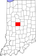
Map of Indiana highlighting Boone County.svg
Boone County's location in Indiana
Location map of Boone County, Indiana.svg
Red pog.svg
Royalton
Location in Boone County
Coordinates: 39°55′37″N86°20′18″W / 39.92694°N 86.33833°W / 39.92694; -86.33833
Country United States
State Indiana
County Boone
Township Eagle
Elevation
[1]
919 ft (280 m)
Time zone UTC-5 (Eastern (EST))
 • Summer (DST) UTC-4 (EDT)
ZIP code
46077
FIPS code 18-66258 [2]
GNIS feature ID 442375

Royalton is an unincorporated community in Eagle Township, Boone County, in the U.S. state of Indiana. [3]

Contents

History

A post office was established at Royalton (but was called Rodmans until 1838 [4] ) in 1832, and remained in operation until it was discontinued in 1903. [5]

Geography and Location

Royalton is located at 39°55′37″N86°20′18″W / 39.92694°N 86.33833°W / 39.92694; -86.33833 . Royalton is located along Indianapolis Rd approximately 0.7 miles northwest of Marion County. The town is made up of three main streets - Royal Avenue, Circle Drive, and Harmon Avenue.

References

  1. ↑ "US Board on Geographic Names". United States Geological Survey. October 25, 2007. Retrieved January 31, 2008.
  2. ↑ "U.S. Census website". United States Census Bureau . Retrieved January 31, 2008.
  3. ↑ "Royalton, Indiana". Geographic Names Information System . United States Geological Survey . Retrieved March 6, 2020.
  4. ↑ Baker, Ronald L. (October 1995). From Needmore to Prosperity: Hoosier Place Names in Folklore and History . Indiana University Press. p.  287. ISBN   978-0-253-32866-3. A post office called Rodmans...
  5. ↑ "Boone County". Jim Forte Postal History. Retrieved August 26, 2014.