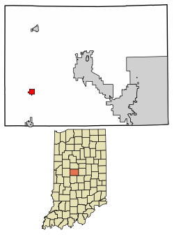
Advance, Indiana | |
---|---|
Coordinates: 39°59′51″N86°37′30″W / 39.99750°N 86.62500°W [1] | |
Country | United States |
State | Indiana |
County | Boone |
Township | Jackson |
Platted | 1872 |
Area | |
• Total | 0.59 sq mi (1.53 km2) |
• Land | 0.59 sq mi (1.53 km2) |
• Water | 0.00 sq mi (0.00 km2) |
Elevation | 929 ft (283 m) |
Population (2020) | |
• Total | 503 |
• Density | 853.99/sq mi (329.66/km2) |
Time zone | UTC−5 (EST) |
• Summer (DST) | UTC−5 (EST) |
ZIP code | 46102 |
Area code | 765 |
FIPS code | 18-00640 |
GNIS ID | 2397419 [3] |
Website | townofadvance |
Advance is a town in Jackson Township, Boone County, Indiana, United States. The population was 503 at the 2020 census.
The town was platted in 1872 and was originally called "Osceola;" however, there was already a town of that name in the state, and so the name of Advance was chosen "in anticipation of the advancement which the coming of the Midland Railway would bring to the community". [4] One of the few streets in town, Wall Street, was named after Joe Wall whose family owned over 2,000 acres (8.1 km2) surrounding the town until 1971.
On May 13, 1995, a tornado struck the town of Advance, causing $2,000,000 worth of damage. [5] [6] This was part of a series of tornadoes that struck the Midwest.
According to the 2010 census, Advance has a total area of 0.62 square miles (1.61 km2), all land. [7]
Census | Pop. | Note | %± |
---|---|---|---|
1910 | 416 | — | |
1920 | 417 | 0.2% | |
1930 | 358 | −14.1% | |
1940 | 365 | 2.0% | |
1950 | 413 | 13.2% | |
1960 | 463 | 12.1% | |
1970 | 561 | 21.2% | |
1980 | 559 | −0.4% | |
1990 | 520 | −7.0% | |
2000 | 562 | 8.1% | |
2010 | 477 | −15.1% | |
2020 | 503 | 5.5% | |
U.S. Decennial Census [8] |
As of the 2010 United States Census, [9] there were 477 people, 161 households, and 121 families living in the town. The population density was 769.4 inhabitants per square mile (297.1/km2). There were 178 housing units at an average density of 287.1 per square mile (110.8/km2). The racial makeup of the town was 97.1% White, 0.4% African American, 0.2% Native American, 0.6% Asian, 0.2% from other races, and 1.5% from two or more races. Hispanic or Latino of any race were 0.8% of the population.
There were 161 households, of which 42.9% had children under the age of 18 living with them, 60.2% were married couples living together, 11.2% had a female householder with no husband present, 3.7% had a male householder with no wife present, and 24.8% were non-families. 19.3% of all households were made up of individuals, and 7.5% had someone living alone who was 65 years of age or older. The average household size was 2.96 and the average family size was 3.39.
The median age in the town was 32.9 years. 32.5% of residents were under the age of 18; 7.2% were between the ages of 18 and 24; 23.1% were from 25 to 44; 27.3% were from 45 to 64; and 9.9% were 65 years of age or older. The gender makeup of the town was 51.8% male and 48.2% female.
As of the 2000 United States Census, [10] there were 562 people, 183 households, and 150 families living in the town. The population density was 898.7 inhabitants per square mile (347.0/km2). There were 190 housing units at an average density of 303.8 per square mile (117.3/km2). The racial makeup of the town was 98.93% White, 0.89% Native American, 0.18% from other races. Hispanic or Latino of any race were 1.25% of the population.
There were 183 households, out of which 45.4% had children under the age of 18 living with them, 68.3% were married couples living together, 7.1% had a female householder with no husband present, and 17.5% were non-families. 13.7% of all households were made up of individuals, and 2.2% had someone living alone who was 65 years of age or older. The average household size was 3.07 and the average family size was 3.40.
In the town, the population was spread out, with 33.5% under the age of 18, 6.9% from 18 to 24, 32.6% from 25 to 44, 20.1% from 45 to 64, and 6.9% who were 65 years of age or older. The median age was 32 years. For every 100 females, there were 93.8 males. For every 100 females age 18 and over, there were 95.8 males.
The median income for a household in the town was $45,000, and the median income for a family was $50,972. Males had a median income of $35,313 versus $21,500 for females. The per capita income for the town was $17,169. About 4.2% of families and 6.9% of the population were below the poverty line, including 7.8% of those under age 18 and 4.1% of those age 65 or over.
Ragland is a town in St. Clair County, Alabama, United States southeast of Ashville. It incorporated in 1899. At the 2020 census, the population was 1,693, up slightly from 1,639 in 2010. It is part of the Birmingham-Hoover-Cullman Combined Statistical Area.
Edinburgh is a town in Johnson, Bartholomew, and Shelby counties in the U.S. state of Indiana. The population was 4,480 at the 2010 census. It is part of the Columbus, Indiana metropolitan statistical area. Edinburgh was named in honor of Edinburgh, Scotland and for many years was pronounced the same way.
Elizabethtown is a town in Sand Creek Township, Bartholomew County, in the U.S. state of Indiana. The population was 504 at the 2010 census. It is part of the Columbus, Indiana metropolitan statistical area.
Marengo is a town in Liberty Township, Crawford County, Indiana, United States. The population was 829 at the 2020 census. One of the tourist attractions and sources of revenue for the town is Marengo Cave, a U.S. National Landmark.
Selma is a town in Liberty Township, Delaware County, Indiana, United States. As of the 2020 census, the town had a total population of 747. It is part of the Muncie, IN Metropolitan Statistical Area.
Dunlap is a census-designated place (CDP) in Elkhart County, Indiana, United States. The population was 6,235 at the 2010 census. Once a small farming community, by the 1980s it had become a suburb of Elkhart and Goshen, Indiana. Most of the town was destroyed by two violent F4 tornadoes during the Palm Sunday Tornado Outbreak on April 11, 1965.
Fort Branch is the largest town and 2nd largest community in Gibson County, Indiana after Princeton. The population was 2,965 at the 2020 census. It is part of the Evansville, Indiana, Metropolitan Area.
Owensville is the third largest town and the smallest of the five larger communities in Gibson County, Indiana, United States. The population was 1,338 in 2020.
Coatesville is a town in Clay Township, Hendricks County, Indiana, United States. The population was 523 at the 2010 Census.
Kennard is a town in Greensboro Township, Henry County, Indiana, United States. The population was 471 at the 2010 census.
River Forest is a town in Anderson Township, Madison County, Indiana, United States. It is part of the Indianapolis–Carmel–Anderson metropolitan statistical area. The population was 26 at the 2020 census.
Winchester is a city in White River Township, Randolph County, Indiana, United States. The city is the county seat of Randolph County. The population was 4,935 at the 2010 census. It is the home of Winchester Speedway.
Holton is a town in Otter Creek Township, Ripley County, in the U.S. state of Indiana. The population was 480 at the 2010 census.
Clear Lake is a town located in the northeast corner of Steuben County, Indiana, in Clear Lake Township. As such, is the northeasternmost community in the State of Indiana. The population was 339 at the 2010 census.
Shelburn is a town in Curry Township, Sullivan County, in the U.S. state of Indiana. The population was 1,252 at the 2010 census. It is part of the Terre Haute Metropolitan Statistical Area.
Sullivan is a city in Hamilton Township and the county seat of Sullivan County, Indiana, United States. The population was 4,249 at the 2010 census. It is part of the Terre Haute Metropolitan Statistical Area.
Minden is a city in Pottawattamie County, Iowa, United States. The population was 600 at the time of the 2020 census.
Wessington Springs is a town and the county seat of Jerauld County, South Dakota, United States. The population was 956 at the 2010 census.
North Crows Nest is a town in Washington Township, Marion County, Indiana, United States. It is approximately 7 miles (11 km) north of downtown Indianapolis. The population was 44 at the 2020 census. It has existed as an "included town" since 1970, when it was incorporated into Indianapolis as part of Unigov. It is part of Indianapolis, but retains town governmental powers under IC 36-3-1-11.
Black Earth is a village in Dane County, Wisconsin, United States. The population was 1,338 at the 2010 census. The village is located within the Town of Black Earth. It is part of the Madison Metropolitan Statistical Area.