Lizton, Indiana

Last updated
Town of Lizton, Indiana
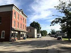
Downtown Lizton.jpg
Downtown Lizton
Nickname: 
"The only Lizton in the world"
Hendricks County Indiana Incorporated and Unincorporated areas Lizton Highlighted 1844442.svg
Location of Lizton in Hendricks County, Indiana.
Coordinates: 39°53′7″N86°32′39″W / 39.88528°N 86.54417°W / 39.88528; -86.54417 Coordinates: 39°53′7″N86°32′39″W / 39.88528°N 86.54417°W / 39.88528; -86.54417
Country United States
State Indiana
County Hendricks
Township Union
Established1851
Area
[1]
  Total0.66 sq mi (1.72 km2)
  Land0.66 sq mi (1.72 km2)
  Water0.00 sq mi (0.00 km2)
Elevation
955 ft (291 m)
Population
 (2020)
  Total511
  Density770.74/sq mi (297.58/km2)
Time zone UTC-5 (Eastern (EST))
  Summer (DST) UTC-4 (EDT)
ZIP code
46149
Area code 317
FIPS code 18-44442 [2]
GNIS feature ID0438191 [3]
Website http://townoflizton.com/

Lizton is a town in Union Township, Hendricks County, Indiana, United States. The population was 488 at the 2010 Census. It is one of the three towns (Pittsboro and North Salem being the other two) that make up North West Hendricks School Corporation.

Contents

History

Lizton was originally called New Elizabeth, and under the latter name was laid out in 1837 by Jesse Veiley, and named for his wife, Elizabeth. [4] [5]

The post office was established as New Elizabeth in 1854, and was renamed Lizton in 1873. [6] According to one source, the name may have been changed by the railroad. [7]

Geography

Lizton Dairy Bar Lizton Dairy Bar.jpg
Lizton Dairy Bar

Lizton is located at 39°53′7″N86°32′39″W / 39.88528°N 86.54417°W / 39.88528; -86.54417 (39.885274, -86.544207). [8]

According to the 2010 census, Lizton has a total area of 0.57 square miles (1.48 km2), all land. [9]

Demographics

Historical population
CensusPop.
1910 224
1920 182−18.7%
1930 21719.2%
1940 200−7.8%
1950 27638.0%
1960 36632.6%
1970 3978.5%
1980 45614.9%
1990 410−10.1%
2000 372−9.3%
2010 48831.2%
2020 5114.7%
U.S. Decennial Census [10]

2010 census

As of the census [11] of 2010, there were 488 people, 197 households, and 137 families living in the town. The population density was 856.1 inhabitants per square mile (330.5/km2). There were 218 housing units at an average density of 382.5 per square mile (147.7/km2). The racial makeup of the town was 97.3% White, 0.4% Asian, 0.8% from other races, and 1.4% from two or more races. Hispanic or Latino of any race were 1.4% of the population.

There were 197 households, of which 39.6% had children under the age of 18 living with them, 45.7% were married couples living together, 15.7% had a female householder with no husband present, 8.1% had a male householder with no wife present, and 30.5% were non-families. 26.4% of all households were made up of individuals, and 5.1% had someone living alone who was 65 years of age or older. The average household size was 2.48 and the average family size was 2.96.

The median age in the town was 32.1 years. 28.5% of residents were under the age of 18; 7% were between the ages of 18 and 24; 34.7% were from 25 to 44; 22.3% were from 45 to 64; and 7.6% were 65 years of age or older. The gender makeup of the town was 53.1% male and 46.9% female.

2000 census

As of the census [2] of 2000, there were 372 people, 161 households, and 100 families living in the town. The population density was 1,303.3 inhabitants per square mile (503.2/km2). There were 180 housing units at an average density of 630.6 per square mile (243.5/km2). The racial makeup of the town was 98.39% White, 0.27% African American, and 1.34% from two or more races.

There were 161 households, out of which 37.9% had children under the age of 18 living with them, 44.1% were married couples living together, 11.8% had a female householder with no husband present, and 37.3% were non-families. 33.5% of all households were made up of individuals, and 11.2% had someone living alone who was 65 years of age or older. The average household size was 2.31 and the average family size was 2.94.

In the town, the population was spread out, with 26.9% under the age of 18, 7.8% from 18 to 24, 36.3% from 25 to 44, 18.8% from 45 to 64, and 10.2% who were 65 years of age or older. The median age was 33 years. For every 100 females, there were 96.8 males. For every 100 females age 18 and over, there were 94.3 males.

The median income for a household in the town was $40,694, and the median income for a family was $55,313. Males had a median income of $36,023 versus $23,750 for females. The per capita income for the town was $20,269. About 3.0% of families and 3.1% of the population were below the poverty line, including 1.5% of those under age 18 and 3.6% of those age 65 or over.
Education

Schools

Both schools are part of the North West Hendricks School Corporation.

Notable people

Related Research Articles

<span class="mw-page-title-main">Jamestown, Indiana</span> Town in Indiana, United States

Jamestown is a town in Jackson Township, Boone County and Eel River Township, Hendricks County, Indiana, United States. The population was 958 at the 2010 census.

<span class="mw-page-title-main">St. Leon, Indiana</span> Town in Indiana, United States

St. Leon is a town in Kelso Township, Dearborn County, Indiana, United States. The population was 678 at the 2010 census.

<span class="mw-page-title-main">Wilkinson, Indiana</span> Town in Indiana, United States

Wilkinson is a town in Brown Township, Hancock County, Indiana, United States. The population was 449 at the 2010 census.

<span class="mw-page-title-main">Clayton, Indiana</span> Town in Indiana, United States

Clayton is a small town in Liberty Township, Hendricks County, Indiana, United States. The population was 972 at the 2010 census, up from 693 at the 2000 census.

<span class="mw-page-title-main">Coatesville, Indiana</span> Town in Indiana, United States

Coatesville is a town in Clay Township, Hendricks County, Indiana, United States. The population was 523 at the 2010 Census.

<span class="mw-page-title-main">Danville, Indiana</span> Town in Indiana, United States

Danville is a town in and the county seat of Hendricks County, Indiana, United States. The population was 9,001 at the 2010 census, up from 6,418 at the 2000 census. In 2019 the estimated population was 10,126.

<span class="mw-page-title-main">North Salem, Indiana</span> Town in Indiana, United States

North Salem is a town in Eel River Township, Hendricks County, Indiana, United States. The population was 518 at the 2010 Census.

<span class="mw-page-title-main">Stilesville, Indiana</span> Town in Indiana, United States

Stilesville is a town in Franklin Township, Hendricks County, Indiana, United States. The population was 316 at the 2010 Census.

<span class="mw-page-title-main">Straughn, Indiana</span> Town in Indiana, United States

Straughn is a town in Dudley Township, Henry County, Indiana, United States. The population was 222 at the 2010 census.

<span class="mw-page-title-main">New Whiteland, Indiana</span> Town in Indiana, United States

New Whiteland is a town in Pleasant Township, Johnson County, Indiana, United States. The population was 5,550 at the 2020 census.

<span class="mw-page-title-main">Ingalls, Indiana</span> Town in Indiana, United States

Ingalls is a town in Green Township, Madison County, Indiana, United States. It is part of the Anderson, Indiana Metropolitan Statistical Area. The population was 2,391 at the 2010 census.

<span class="mw-page-title-main">Marshall, Indiana</span> Town in Indiana, United States

Marshall is a town in Washington Township, Parke County, in the U.S. state of Indiana. As of the 2010 census, the population was 324.

<span class="mw-page-title-main">Bainbridge, Indiana</span> Town in Indiana, United States

Bainbridge is a town in Monroe Township, Putnam County, in the U.S. state of Indiana. The population was 746 at the 2010 census.

<span class="mw-page-title-main">Poneto, Indiana</span> Town in Indiana, United States

Poneto is a town in Chester, Harrison and Liberty townships, Wells County, in the U.S. state of Indiana. The population was 166 at the 2010 census.

<span class="mw-page-title-main">Roy, Washington</span> City in Washington, United States

Roy is a city in Pierce County, Washington, United States. The population was 816 at the 2020 census.

<span class="mw-page-title-main">Hendricks, West Virginia</span> Town in West Virginia, United States

Hendricks is a town in Tucker County, West Virginia, United States. The population was 226 at the 2020 census. The Blackwater River and the Dry Fork join at Hendricks to form the Black Fork, a principal tributary of the Cheat River.

<span class="mw-page-title-main">Fontana-on-Geneva Lake, Wisconsin</span> Village in Wisconsin, United States

Fontana-on-Geneva Lake is a village located on Geneva Lake in Walworth County, Wisconsin, United States. The population was 1,672 at the 2010 census.

<span class="mw-page-title-main">North Crows Nest, Indiana</span> Town in Indiana, United States

North Crows Nest is a town in Washington Township, Marion County, Indiana. The town is approximately 7 miles (11 km) northwest of downtown Indianapolis. The town is adjacent to the neighboring community of Crows Nest. The population was 45 at the 2010 census. It has existed as an "included town" since 1970, when it was incorporated into Indianapolis as part of Unigov. It is part of Indianapolis, but retains town governmental powers under IC 36-3-1-11.

<span class="mw-page-title-main">Spring Hill, Indiana</span> Town in Indiana, United States

Spring Hill is a town in Marion County, Indiana, United States. The population was 98 at the 2010 census. It has existed as an "included town" since 1970, when it was incorporated into Indianapolis as part of Unigov. It is part of Indianapolis, but retains town governmental powers under IC 36-3-1-11.

<span class="mw-page-title-main">Warren Park, Indiana</span> Town in Indiana, United States

Warren Park is a town in Warren Township, Marion County, Indiana. The population was 1,480 at the 2010 census. It has existed as an "included town" since 1970, when it was incorporated into Indianapolis as part of Unigov. It is part of Indianapolis, but retains a functioning town government under IC 36-3-1-11.

References

  1. "2020 U.S. Gazetteer Files". United States Census Bureau. Retrieved March 16, 2022.
  2. 1 2 "U.S. Census website". United States Census Bureau . Retrieved 2008-01-31.
  3. "US Board on Geographic Names". United States Geological Survey. 2007-10-25. Retrieved 2008-01-31.
  4. Hadley, John Vestal (1914). History of Hendricks County, Indiana: Her People, Industries and Institutions. B.F. Bowen. p. 98.
  5. History of Hendricks County, Indiana: Together with Sketches of Its Cities, Villages and Towns, Educational, Religious, Civil, Military, and Political History, Portraits of Prominent Persons, and Biographies of Representative Citizens. Inter-State Publishing Company. 1885. p. 718.
  6. "Hendricks County". Jim Forte Postal History. Retrieved 20 September 2014.
  7. Baker, Ronald L. (October 1995). From Needmore to Prosperity: Hoosier Place Names in Folklore and History. Indiana University Press. p. 200. ISBN   978-0-253-32866-3. According to the WPA files, the railroad shortened the name to Lizton.
  8. "US Gazetteer files: 2010, 2000, and 1990". United States Census Bureau. 2011-02-12. Retrieved 2011-04-23.
  9. "G001 - Geographic Identifiers - 2010 Census Summary File 1". United States Census Bureau . Retrieved 2015-07-17.
  10. "Census of Population and Housing". Census.gov. Retrieved June 4, 2015.
  11. "U.S. Census website". United States Census Bureau . Retrieved 2012-12-11.
  12. "Cowboys' 53-man roster analysis: A position-by-position look at who made initial team". The Dallas Morning News. Retrieved August 31, 2022.