Cicero, Indiana

Last updated

Cicero, Indiana
Cicero
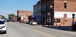
Downtown Cicero Indiana.jpg
Cicero has grown around the north end of the Morse Reservoir
Hamilton County Indiana Incorporated and Unincorporated areas Cicero Highlighted 1812628.svg
Location of Cicero in Hamilton County, Indiana.
Coordinates: 40°07′39″N86°01′23″W / 40.12750°N 86.02306°W / 40.12750; -86.02306
Country United States
State Indiana
County Hamilton
Township Jackson
Area
[1]
  Total2.04 sq mi (5.29 km2)
  Land1.63 sq mi (4.22 km2)
  Water0.41 sq mi (1.07 km2)
Elevation
[2]
810 ft (250 m)
Population
 (2020)
  Total5,301
  Density3,254.14/sq mi (1,256.60/km2)
Time zone UTC-5 (EST)
  Summer (DST) UTC-5 (EST)
ZIP code
46034
Area code 317
FIPS code 18-12628 [3]
GNIS feature ID2396646 [2]
Website http://www.ciceroin.org
Sign welcoming visitors to Cicero Indiana Sign welcoming visitors to Cicero Indiana.jpg
Sign welcoming visitors to Cicero Indiana
Morse reservoir near Cicero Morse reservoir near Cicero.jpg
Morse reservoir near Cicero

Cicero is a town in Jackson Township, Hamilton County, Indiana, United States, north of Indianapolis. The population was 4,812 at the 2010 census.

Contents

Cicero is notable for welcoming teenaged AIDS activist Ryan White to its community in 1987. [4] White is buried in Cicero.

History

Cicero was founded in 1835. [5] The town took its name from Cicero Creek. [6] The first post office in Jackson Township was established at Cicero in 1839. [7]

The construction of Morse Reservoir in 1956, the northern end of which lies in Cicero, brought more development to the town as well. [8]

Geography

Cicero is located on the northeast shore of Morse Reservoir.

According to the 2010 census, Cicero has a total area of 2.12 square miles (5.49 km2), of which 1.71 square miles (4.43 km2) (or 80.66%) is land and 0.41 square miles (1.06 km2) (or 19.34%) is water. [9]

Demographics

Historical population
CensusPop.Note
1860 278
1870 42251.8%
1880 71569.4%
1890 631−11.7%
1900 1,603154.0%
1910 990−38.2%
1920 906−8.5%
1930 9333.0%
1940 9431.1%
1950 1,0218.3%
1960 1,28425.8%
1970 1,3787.3%
1980 2,55785.6%
1990 3,26827.8%
2000 4,30331.7%
2010 4,81211.8%
2020 5,30110.2%
U.S. Decennial Census [10]

Cicero is largely a lakeside community.

2010 census

As of the census [11] of 2010, there were 4,812 people, 1,952 households, and 1,381 families living in the town. The population density was 2,814.0 inhabitants per square mile (1,086.5/km2). There were 2,167 housing units at an average density of 1,267.3 per square mile (489.3/km2). The racial makeup of the town was 96.8% White, 0.6% African American, 0.6% Native American, 0.5% Asian, 0.4% from other races, and 1.1% from two or more races. Hispanic or Latino of any race were 1.5% of the population.

There were 1,952 households, of which 34.8% had children under the age of 18 living with them, 53.6% were married couples living together, 11.3% had a female householder with no husband present, 5.8% had a male householder with no wife present, and 29.3% were non-families. 24.5% of all households were made up of individuals, and 8.2% had someone living alone who was 65 years of age or older. The average household size was 2.47 and the average family size was 2.89.

The median age in the town was 39.8 years. 25.2% of residents were under the age of 18; 6.6% were between the ages of 18 and 24; 25.6% were from 25 to 44; 31% were from 45 to 64; and 11.6% were 65 years of age or older. The gender makeup of the town was 49.2% male and 50.8% female.

2000 census

As of the census [3] of 2000, there were 4,303 people, 1,716 households, and 1,257 families living in the town. The population density was 2,877.8 inhabitants per square mile (1,111.1/km2). There were 1,811 housing units at an average density of 1,211.2 per square mile (467.6/km2). The racial makeup of the town was 97.89% White, 0.19% African American, 0.30% Native American, 0.28% Asian, 0.02% Pacific Islander, 0.63% from other races, and 0.70% from two or more races. Hispanic or Latino of any race were 1.12% of the population.

There were 1,716 households, out of which 36.0% had children living with them, 59.2% were married couples living together, 10.0% had a female householder with no husband present, and 26.7% were non-families. 21.4% of all households were made up of individuals, and 6.5% had someone living alone who was 65 years of age or older. The average household size was 2.51 and the average family size was 2.92.

In the town, the population was spread out, with 26.4% under the age of 18, 8.2% from 18 to 24, 32.3% from 25 to 44, 24.6% from 45 to 64, and 8.5% who were 65 years of age or older. The median age was 36 years. For every 100 females, there were 96.2 males. For every 100 females age 18 and over, there were 96.0 males.

The median income for a household in the town was $54,561, and the median income for a family was $60,559. Males had a median income of $39,131 versus $29,574 for females. The per capita income for the town was $23,169. About 0.7% of families and 1.7% of the population were below the poverty line, including none of those under age 18 and 2.8% of those age 65 or over.
Education

Cicero is served by Hamilton Heights School Corporation, Indiana Academy [12] and Cicero Seventh-day Adventist Elementary School. [13]

The town has a lending library, the Hamilton North Public Library. [14]

Media

The plot of the episode entitled "The Kids Are All Right" from the TV series Supernatural took place in the town of Cicero, Indiana. However, it does not accurately depict the town, much to the disappointment of certain fans.

Cicero Seventh-day Adventist Church [15] is the home of the Hope for Life television ministry, with Pastors Aaron Clark, Vic Van Schaik, and Associate Pastor Cristopher Saures. [16]

The town was represented in the 1989 biopic The Ryan White Story as the town to which Ryan White moved order to escape prejudice in Kokomo, Indiana. [17] However, it is only featured in the last two scenes of the movie.

Related Research Articles

<span class="mw-page-title-main">Jamestown, Indiana</span> Town in Indiana, United States

Jamestown is a town in Jackson Township, Boone County and Eel River Township, Hendricks County, Indiana, United States. The population was 958 at the 2010 census.

<span class="mw-page-title-main">St. Paul, Indiana</span> Town in Indiana, United States

St. Paul or Saint Paul is a small town on the border of Decatur and Shelby counties in the U.S. state of Indiana. The population was 1,031 at the 2010 census.

<span class="mw-page-title-main">Ashley, Indiana</span> Town in Indiana, United States

Ashley is a town in Indiana located on the border of Smithfield Township, DeKalb County and Steuben Township, Steuben County. The population was 983 at the 2010 census.

<span class="mw-page-title-main">Hamilton, Indiana</span> Town in Indiana, United States

Hamilton is a town located on the border of Steuben County, Indiana and DeKalb County, Indiana. In Steuben County, it is in Otsego Township, and in DeKalb County it is in Franklin Township. The population was 1,532 at the 2010 census.

<span class="mw-page-title-main">Chesterfield, Indiana</span> Town in Indiana, United States

Chesterfield is a town in the U.S. state of Indiana which lies in Union Township, Madison County, and Salem Township, Delaware County. The population was 2,490 at the 2020 census. It is part of the Indianapolis–Carmel–Anderson metropolitan statistical area.

<span class="mw-page-title-main">Selma, Indiana</span> Town in Indiana, United States

Selma is a town in Liberty Township, Delaware County, Indiana, United States. As of the 2020 census, the town had a total population of 747. It is part of the Muncie, IN Metropolitan Statistical Area.

<span class="mw-page-title-main">Atlanta, Indiana</span> Town in Indiana, United States

Atlanta is a town in Jackson Township, Hamilton County, Indiana, United States. The population was 725 at the 2010 census.

<span class="mw-page-title-main">Fortville, Indiana</span> Town in Indiana, United States

Fortville is a town in Vernon Township, Hancock County, Indiana, United States. The population was 4,784 at the 2020 census.

<span class="mw-page-title-main">Spring Lake, Indiana</span> Town in Indiana, United States

Spring Lake is a town in Sugar Creek Township, Hancock County, Indiana, United States, along Sugar Creek. The population was 218 at the 2010 census.

<span class="mw-page-title-main">Wilkinson, Indiana</span> Town in Indiana, United States

Wilkinson is a town in Brown Township, Hancock County, Indiana, United States. The population was 449 at the 2010 census.

<span class="mw-page-title-main">Andrews, Indiana</span> Town in Indiana, United States

Andrews is a town in Dallas Township, Huntington County, Indiana, United States. The population was 1,048 at the 2020 census.

<span class="mw-page-title-main">Ingalls, Indiana</span> Town in Indiana, United States

Ingalls is a town in Green Township, Madison County, Indiana, United States. It is part of the Indianapolis–Carmel–Anderson metropolitan statistical area. The population was 2,223 at the 2020 census.

<span class="mw-page-title-main">Bethany, Indiana</span> Town in Indiana, United States

Bethany is a town in Clay Township, Morgan County, in the U.S. state of Indiana. The population was 95 at the 2020 census.

<span class="mw-page-title-main">Paoli, Indiana</span> Town in Indiana, United States

Paoli is a town within Paoli Township and the county seat of Orange County, in the U.S. state of Indiana. The population was 3,677 at the 2010 census.

<span class="mw-page-title-main">Clear Lake, Indiana</span> Town in Indiana, United States

Clear Lake is a town located in the northeast corner of Steuben County, Indiana, in Clear Lake Township. As such, is the northeasternmost community in the State of Indiana. The population was 339 at the 2010 census.

Palmyra is a town in Somerset County, Maine, United States. The population was 1,924 at the 2020 census.

<span class="mw-page-title-main">Harrison, Ohio</span> City in Ohio, United States

Harrison is a city in western Hamilton County, Ohio, United States. The population was 12,563 at the 2020 census. It is part of the Cincinnati metropolitan area.

<span class="mw-page-title-main">Cicero, Wisconsin</span> Town in Wisconsin, United States

Cicero is a town in Outagamie County, Wisconsin, United States. The population was 1,092 at the 2000 census.

<span class="mw-page-title-main">Meridian Hills, Indiana</span> Town in Indiana, United States

Meridian Hills is a town in Washington Township, Marion County, Indiana, about 8 miles (13 km) north of downtown Indianapolis. It had a population of 1,774 at the 2020 census, up from 1,616 in 2010.

<span class="mw-page-title-main">Wynnedale, Indiana</span> Town in Indiana, United States

Wynnedale is a town in Washington Township, Marion County, Indiana, United States. The population was 215 at the 2020 census. It has existed as an "included town" since 1970, when it was incorporated into Indianapolis as part of Unigov. It is part of Indianapolis, but retains a functioning town government under IC 36-3-1-11.

References

  1. "2020 U.S. Gazetteer Files". United States Census Bureau. Retrieved March 16, 2022.
  2. 1 2 U.S. Geological Survey Geographic Names Information System: Cicero, Indiana
  3. 1 2 "U.S. Census website". United States Census Bureau . Retrieved January 31, 2008.
  4. Pohlen, Jerome (June 1, 2008). Progressive Nation: A Travel Guide with 400+ Left Turns and Inspiring Landmarks. Chicago Review Press. p. 248. ISBN   978-1-56976-484-8.
  5. "Hamilton County History Timeline". Carmel Clay Historical Society. Archived from the original on April 19, 2021. Retrieved May 31, 2014.
  6. Exploring Indiana Highways: Trip Trivia. Exploring America's Highway. 2007. p. 265. ISBN   978-0-9744358-3-1.
  7. Shirts, Augustus Finch (1901). A History of the Formation, Settlement and Development of Hamilton County, Indiana: From the Year 1818 to the Close of the Civil War. Shirts. pp.  202.
  8. "Town History". Town of Cicero. Retrieved October 12, 2023.
  9. "G001 - Geographic Identifiers - 2010 Census Summary File 1". United States Census Bureau. Archived from the original on February 13, 2020. Retrieved July 14, 2015.
  10. "Census of Population and Housing". Census.gov. Retrieved June 4, 2015.
  11. "U.S. Census website". United States Census Bureau . Retrieved December 11, 2012.
  12. "Indiana public library directory" (PDF). Indiana State Library. Archived from the original (PDF) on February 18, 2017. Retrieved March 7, 2018.
  13. Hope for Life Media Ministry
  14. "Remembering Ryan White".