Home Place, Indiana

Last updated

Home Place, Indiana
Neighborhood
HomePlace99thCollege.png
Hamilton County Indiana Incorporated and Unincorporated areas Carmel Highlighted 1810342.svg
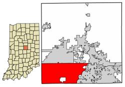
Map of Hamilton County showing Home Place within the city limits of Carmel
Coordinates: 39°56′38″N86°08′36″W / 39.94389°N 86.14333°W / 39.94389; -86.14333
Country United States
State Indiana
County Hamilton
Settled1832
Town plotted1914
Area
  Total1.59 sq mi (4.1 km2)
  Land1.57 sq mi (4.1 km2)
  Water0.02 sq mi (0.05 km2)  1.26%
Elevation
[1]
846 ft (258 m)
Time zone UTC-5 (EST)
  Summer (DST) UTC-5 (EST)
ZIP codes
46280
Area code(s) 317, 463
GNIS feature ID436367 [1]
Website Home Place, Indiana website

Home Place is a neighborhood within the city of Carmel, Indiana, in the United States. [1] Home Place was previously an unincorporated community of 1,017 acres (412 ha) in Clay Township, Hamilton County, Indiana, that had resisted annexation attempts by Carmel since 2004. [2] However, in June 2016, a special judge ruled that residents of Home Place had failed to meet all the requirements to prevent the annexation, and that Carmel could move forward with the annexation. [3] After that decision was upheld by the Indiana Court of Appeals in October 2017, representatives of the Home Place residents reached an agreement with city leaders. On March 1, 2018, Carmel completed the annexation of the Home Place community. [4]

History

Home Place was laid out in 1914 along the Union Traction interurban line between Indianapolis and points north. [5] Although officially annexed by Carmel in 2018, Home Place did retain its historical Indianapolis postal code. Mail is delivered by the Nora, Indianapolis post office, in neighboring Marion County, Indiana.

Related Research Articles

<span class="mw-page-title-main">Indianapolis</span> Capital of Indiana, United States

Indianapolis, colloquially known as Indy, is the capital and most populous city of the U.S. state of Indiana and the seat of Marion County. Located in Central Indiana, the city lies along the White River's West Fork near its confluence with Fall Creek.

<span class="mw-page-title-main">Hancock County, Indiana</span> County in Indiana, United States

Hancock County is a county in the U.S. state of Indiana. The 2020 United States Census recorded a population of 79,840. The county seat is Greenfield.

<span class="mw-page-title-main">Hamilton County, Indiana</span> County in Indiana, United States

Hamilton County is a county in the U.S. state of Indiana. The 2020 United States Census recorded a population of 347,467. The county seat is Noblesville.

<span class="mw-page-title-main">Gibson County, Indiana</span> County in Indiana, United States

Gibson County is a county in the southwestern part of the U.S. state of Indiana. As of the 2020 United States Census, the population was 33,011. The county seat is Princeton.

<span class="mw-page-title-main">Carmel, Indiana</span> City in Indiana, United States

Carmel is a suburban city in Hamilton County, Indiana, United States, immediately north of Indianapolis. With a population of 99,757 as of the 2020 census, the city spans 49 square miles (130 km2) across Clay Township and is bordered by the White River to the east and the Boone County line to the west. Although Carmel was home to one of the first electronic automated traffic signals in the country, the city has constructed 141 roundabouts between 1988 and 2022.

<span class="mw-page-title-main">Fishers, Indiana</span> City in Indiana, United States

Fishers is a city in Fall Creek and Delaware townships, Hamilton County, Indiana, United States. As of the 2010 census the population was 76,794, and by 2019 the estimated population was 95,310. A suburb of Indianapolis, Fishers has grown rapidly in recent decades: about 350 people lived there in 1963, 2,000 in 1980, and only 7,500 as recently as 1990.

<span class="mw-page-title-main">Noblesville, Indiana</span> City in Indiana, United States

Noblesville is a city in and the county seat of Hamilton County, Indiana, United States, a part of the north Indianapolis suburbs along the White River. The population was 69,604 at the 2020 census, making it the state's 10th most populous city, up from 14th in 2010. The city is part of Delaware, Fall Creek, Noblesville, and Wayne townships.

<span class="mw-page-title-main">Westfield, Indiana</span> City in Indiana, United States

Westfield is a city in Hamilton County, Indiana, United States. As of the 2010 census the population was 30,068, and in 2023 the population was 58,410. Westfield is in the Indianapolis metropolitan area.

<span class="mw-page-title-main">Greenwood, Indiana</span> City in Indiana, United States

Greenwood is a city in Johnson County, Indiana, United States. The population was 63,830 at the 2020 Census. Greenwood is located southeast of central Indianapolis between Indiana State Road 37 and Interstate 65. The city shares a border with Indianapolis and is the most populous suburban municipality in the southern portion of the Indianapolis Metropolitan Area.

<span class="mw-page-title-main">Crawfordsville, Indiana</span> City in Indiana, United States

Crawfordsville is a city in Montgomery County in west central Indiana, United States, 49 miles (79 km) west by northwest of Indianapolis. As of the 2020 census, the city had a population of 16,306. The city is the county seat of Montgomery County, the only chartered city and the largest populated place in the county. It is the principal city of the Crawfordsville, IN Micropolitan Statistical Area, which encompasses all of Montgomery County. The city is also part of the Indianapolis–Carmel–Muncie, IN Combined Statistical Area.

<span class="mw-page-title-main">West Lafayette, Indiana</span> City in Indiana, United States

West Lafayette is a city in Wabash Township, Tippecanoe County, Indiana, United States, about 65 miles (105 km) northwest of the state capital of Indianapolis and 113 miles (182 km) southeast of Chicago. West Lafayette is directly across the Wabash River from its sister city, Lafayette. As of the 2020 census, its population was 44,595. A college town, it is the most densely populated city in Indiana and is home to Purdue University.

<span class="mw-page-title-main">Monon Trail</span> Shared-use path and rail trail in the U.S. state of Indiana

The Monon Trail is a rail trail located entirely within the state of Indiana. The Monon Railroad was a popular railroad line connecting the cities of Chicago and Indianapolis, with stops at major settlements along its route. After the decline of railroad travel and the sale of the company in 1987, the portion of the line between Indianapolis and Delphi, Indiana, was abandoned.

<span class="mw-page-title-main">Carmel High School (Indiana)</span> Public high school in Carmel, Indiana, United States

Carmel High School (CHS) is a public high school in Carmel, Indiana, United States, and part of the Carmel Clay Schools District.

<span class="mw-page-title-main">Marsh Supermarkets</span> Defunct grocery chain based in central Indiana

Marsh Supermarkets was an American retail food chain headquartered in Indianapolis, Indiana, with a peak number of 86 stores in 2013 located throughout central Indiana and parts of western Ohio. Its eventual parent company was Sun Capital Partners, headquartered in Boca Raton, Florida.

<span class="mw-page-title-main">Irvington Historic District (Indianapolis)</span> Historic district in Indiana, United States

The neighborhood of Irvington, named after Washington Irving, includes Irvington Historic District, a historic district in Indianapolis, Indiana. The historic district is a 545-acre (221 ha) area that was listed on the National Register of Historic Places in 1987. That year, the district included 2,373 contributing buildings, 5 other contributing structures, and 2 contributing sites.

Geist is an affluent area in northeastern Indianapolis, Indiana and southeastern Hamilton County in Fishers, Indiana. It is named for Geist Reservoir.

Avriel Shull was an American architectural designer/builder and interior decorator whose career spanned from the 1950s until her death in 1976. She is best known for her mid-century modern architectural designs, which are especially unusual given the predominantly traditional tastes of mid-century Indiana. Most of Shull's projects were single-family homes around Hamilton and Marion counties in central Indiana, most notably the homes in Christie's Thornhurst Addition in Carmel, Indiana. Shull also designed a number of custom homes in Indianapolis's toniest suburbs, in other Indiana towns, and in other states. In the 1970s Shull began selling house plans in do-it-yourself home building periodicals, which were sold in the United States and Canada. Shull also designed apartment buildings and commercial/industrial properties. Her first major project outside of Indiana was a public library in Elkins, West Virginia. She also did designs for restaurants, including one in California and one in Carmel, Indiana.

<span class="mw-page-title-main">Clay Township, Hamilton County, Indiana</span> Township in Indiana, United States

Clay Township is one of nine townships in Hamilton County, Indiana, United States. As of the 2010 census, its population was 83,293 and it contained 32,375 housing units. Since the annexation of Home Place, Indiana; Carmel is now completely coterminous with the township.

<span class="mw-page-title-main">Indiana</span> U.S. state

Indiana is a U.S. state in the Midwestern United States. It is the 38th-largest by area and the 17th-most populous of the 50 States. Its capital and largest city is Indianapolis. Indiana was admitted to the United States as the 19th state on December 11, 1816. It is bordered by Lake Michigan to the northwest, Michigan to the north and northeast, Ohio to the east, the Ohio River and Kentucky to the south and southeast, and the Wabash River and Illinois to the west.

Charles Patrick White is the former Republican Indiana Secretary of State, having been first elected to the statewide executive position in November 2010. Prior to that, he served as Chairman of the Hamilton County Republican Party and as a member of the town council of Fishers, a northern suburb of Indianapolis.

References

  1. 1 2 3 U.S. Geological Survey Geographic Names Information System: Home Place, Indiana
  2. "History of Home Place forced annexation". homeplaceindiana.com. Archived from the original on March 4, 2016. Retrieved June 22, 2016.
  3. Erdody, Lindsey (June 22, 2016). "Court rules in favor of Carmel in Home Place annexation case". Indianapolis Business Journal. Retrieved June 22, 2016.
  4. "Home Place annexation begins today". Current Publishing. March 1, 2018. Retrieved May 29, 2021.
  5. Haines, John F. (1915). History of Hamilton County, Indiana: Her People, Industries And Institutions, Volume 1. B.F. Bowen & Co. p. 263.