Noblesville, Indiana

Last updated

Noblesville, Indiana
City
Noblesville-indiana-downtown.jpg
Downtown Noblesville
Motto: 
The Heart of Hamilton County
Hamilton County Indiana Incorporated and Unincorporated areas Noblesville Highlighted 1854180.svg
Location of Noblesville in Hamilton County, Indiana.
Coordinates: 40°01′30″N85°57′10″W / 40.02500°N 85.95278°W / 40.02500; -85.95278
CountryUnited States
State Indiana
County Hamilton
Founded1823
Incorporated (town)1851
Incorporated (city)1887
Government
   Mayor Chris Jensen (R)[ citation needed ]
Area
[1]
  Total35.82 sq mi (92.77 km2)
  Land34.40 sq mi (89.08 km2)
  Water1.42 sq mi (3.69 km2)
Elevation
[2]
771 ft (235 m)
Population
 (2020)
  Total69,604
  Density2,023.67/sq mi (781.34/km2)
Time zone UTC−5 (EST)
  Summer (DST) UTC−4 (EDT)
ZIP codes
46060, 46061, 46062
Area code 317
FIPS code 18-54180 [3]
GNIS feature ID2395240 [2]
Website www.cityofnoblesville.org

Noblesville is a city in and the county seat of Hamilton County, Indiana, United States, [4] a part of the north Indianapolis suburbs along the White River. The population was 69,604 at the 2020 census, making it the state's 10th most populous city, up from 14th in 2010. The city is part of Delaware, Fall Creek, Noblesville, and Wayne townships.

Contents

Noblesville is home to Ruoff Music Center (formerly Klipsch Music Center and Deer Creek Music Center), the Indianapolis metro area’s primary outdoor music venue. Since its opening in 1989, the nearly 25,000-seat amphitheater has been a popular stop for many touring musicians, consistently ranking first (or in the top three) among outdoor music venues in the world, for ticket sales, according to Pollstar . [5]

History

Potter's Covered Bridge Potters Bridge.jpg
Potter's Covered Bridge

Noblesville's history dates to 1818 when the government purchased the land that is now Hamilton County from the Native Americans in this area. William Conner, the only settler living in the area at the time, and his wife Mekinges Conner, a Lenape woman, established the first trading post in central Indiana in 1802 and lived in the area's first log cabin. William Conner and Josiah Polk laid out what is now downtown Noblesville in 1823, which was designated as the Hamilton County seat in 1824 and incorporated in 1851. Conner's 1823 home is now one of a village of historic buildings that make up Conner Prairie Pioneer Settlement, a living history museum south of Noblesville in Fishers.

Noblesville was named either for James Noble, one of the first two U.S. senators from Indiana, or, according to legend, for Lavina Noble of Indianapolis, to whom Josiah Polk was engaged.

The Peru and Indianapolis Railroad was completed through town in 1851, strengthening the town economically and causing the population to increase. In 1875 work began on the town's second railroad, the Anderson, Lebanon and St. Louis, later known as the Midland. [6] :122

The city's first large growth period occurred during the Indiana gas boom, with the discovery in 1888 of Noblesville's first natural gas well near 11th and Pleasant streets. Many Victorian homes, as well as most of the downtown commercial district, were built during this time of prosperity. The city has undergone another increase recently as its population grew from 28,590 in 2000 to 51,969 in 2010. This growth echoes the increase in population of much of southern Hamilton County due to its proximity to Indianapolis.

Noblesville was once noted for its flour mills, the mostly widely known of which was the Noblesville Milling Company, producer of Diadem and Kismet flours. In 1925, the manager of the company offered to buy uniforms for the local high school athletic team in exchange for the school adopting the nickname "Millers". The nickname persists to this day. [7]

Other prominent businesses included the Union Sanitary Manufacturing Company, the American Strawboard Company and Firestone Industrial Products.

Among the notable disasters that have struck the town are the Great Flood of 1913, an interurban wreck on the courthouse square in 1919, [6] :126 and the Goeke fire of 1967. The fire, which began at the Paul Goeke auto dealership just off the square, destroyed two buildings and killed a firefighter'.

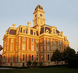
The old Hamilton County Sheriff's Residence and Jail on the southwest corner of the courthouse square in downtown Noblesville is now the home of the Hamilton County Museum of History. As a working jail, it once housed Charles Manson as a teenager and D. C. Stephenson, former Grand Dragon of the Indiana Ku Klux Klan. The Stephenson trial, which took place in the adjoining Hamilton County courthouse in 1925, broke the power of the Klan in Indiana and drew national attention to Noblesville. Stephenson was convicted of second-degree murder in the death of Madge Oberholtzer.

During the early 1920s, Noblesville was one of several Indiana towns where the Ku Klux Klan was active, but the Klan's influence quickly faded after Stephenson's conviction. In 1973 Klansmen staging a march in Noblesville were met by counter-demonstrators carrying anti-Klan placards. [8]

In 1995, a local contractor stumbled across a trunk containing Klan paraphernalia and membership records from the 1920s. The debate over how to handle the sensitive issue again put Noblesville in the national spotlight. [9] The Hamilton County Historical Society, which received donated materials, opted to keep the public from seeing the former members' names.

Noblesville also attracted national media attention in 1965 when Noblesville Daily Ledger editor James T. Neal was charged with contempt by Hamilton County Circuit Court judge Ed New. Neal's fight for the First Amendment went before the Indiana Supreme Court. [10] In May 2018, it drew national attention again as the Noblesville West Middle School was the site of a school shooting with a teacher and student injured. [11]

List of mayors

TermMayor
1851David Moss
1887 – 1889Edgar C. Wilson
1889 – 1890John F. Neal
1891 – 1894James W. Smith
1895 – 1899Edgar C. Wilson
1900 – 1902Albert R. Baker
1903 – 1903George Snyder
1904 – 1906John L. Dulin
1907 – 1909Edgar C. Wilson
1910 – 1917Dr. E. C. Loehr
1918 – 1921D. B. "Jack" McCoun
1922 – 1925H. G. "Pop" Brown
1926 – 1929J. X. Joseph
1930 – 1934William E. Gifford
1935 – 1938H. G. "Pop" Brown
1939 – 1951Emmett R. Fertig
1952 – 1958Herman Lawson
1958Gordon Olvey
1958 – 1959John R. Neal
1960 – 1963Dale Hanshew
1963John R. Neal
1964 – 1971Joe Butler
1972 – 1975Max Robinson
1976 – 1979Robert V. Wical
1980 – 1987Patricia Logan
1988 – 1995Mary Sue Rowland
1996 – 2003Dennis R. Redick
2004 – 2019John Ditslear
2020 – presentChris Jensen

[12]

Current City Council

The Council consists of nine members (new as of January 1, 2016, when Noblesville became a Second Class City in Indiana). Three are elected across the city (at large) and six are elected specific to certain areas of the city (districts).[ citation needed ]

DistrictCouncil member
1stMike Davis
2ndPete Schwartz
3rdAaron Smith
4thDan Spartz
5thGreg O'Connor
6thMegan Wiles
At-LargeBrian Ayer
At-LargeDarren Peterson
At-LargeMark Boice

[13]

Architecture

Hamilton County Courthouse Noblesville-indiana-county-seat.jpg
Hamilton County Courthouse

The centerpiece of downtown Noblesville is the Courthouse Square, the location of the Hamilton County Courthouse (completed in 1879) and the Hamilton County Sheriff's Residence and Jail (constructed in 1876). Both buildings are fabulous examples of the Second Empire style featuring mansard roofs. Sites and buildings in Noblesville that are listed on the National Register of Historic Places include the Hamilton County Courthouse Square, the Catherine Street Historic District, Cole-Evans House, Conner Street Historic District, William Houston Craig House, Daniel Craycraft House, Dr. Samuel Harrell House, Holliday Hydroelectric Powerhouse and Dam, Nickel Plate Road Steam Locomotive No. 587, Noblesville Commercial Historic District, Noblesville Milling Company Mill, South 9th Street Historic District, Judge Earl S. Stone House, and Robert L. Wilson House. [14]

Geography

Noblesville is located in central Hamilton County and is bordered to the north by Cicero, to the south by Fishers and Carmel, and to the west by Westfield. A narrow portion of Noblesville extends east to the Madison County line, where it is bordered by the town of Ingalls.

Noblesville is 23 miles (37 km) north-northeast of downtown Indianapolis. Indiana State Road 37 is the main highway through the city, running east of downtown. It leads south to Interstate 69 in Fishers and thence to Indianapolis, and northeast 43 miles (69 km) to Marion. Conner Street, carrying state routes 32 and 38, is the main east–west road through the center of Noblesville. SR 32 leads east-northeast 18 miles (29 km) to Anderson and west 6 miles (10 km) to Westfield, while SR 38 leads east-southeast 14 miles (23 km) to Pendleton and northwest 13 miles (21 km) to Sheridan. Indiana State Road 19 runs north from Noblesville, leading 17 miles (27 km) to Tipton.

According to the 2010 census, Noblesville has a total area of 32.785 square miles (84.91 km2), of which 31.37 square miles (81.25 km2) (or 95.68%) is land and 1.415 square miles (3.66 km2) (or 4.32%) is water. [15]

Demographics

Historical population
CensusPop.Note
1850 664
1860 1,11567.9%
1870 1,43528.7%
1880 2,22154.8%
1890 3,05437.5%
1900 4,79256.9%
1910 5,0735.9%
1920 4,758−6.2%
1930 4,8111.1%
1940 5,57515.9%
1950 6,56717.8%
1960 7,66416.7%
1970 7,548−1.5%
1980 12,05659.7%
1990 17,65546.4%
2000 28,59061.9%
2010 51,96981.8%
2020 69,60433.9%
Source: US Census Bureau

As of 2000, the median income for a household in the city was $73,395, and the median per capita income was $33,732. Approximately 45.22% of the population has a higher education degree with over 87.3% of the population at least having a high school diploma or GED. The median housing value is $171,272 with a total of 17,915 housing units.

2010 census

As of the census [16] of 2010, there were 51,969 people, 19,080 households, and 13,989 families residing in the city. The population density was 1,656.6 inhabitants per square mile (639.6/km2). There were 21,121 housing units at an average density of 673.3 per square mile (260.0/km2). The racial makeup of the city was 91.1% White, 3.6% African American, 0.2% Native American, 1.7% Asian, 0.1% Pacific Islander, 1.6% from other races, and 1.8% from two or more races. Hispanic or Latino of any race were 4.3% of the population.

There were 19,080 households, of which 42.9% had children under the age of 18 living with them, 58.3% were married couples living together, 10.8% had a female householder with no husband present, 4.2% had a male householder with no wife present, and 26.7% were non-families. 21.6% of all households were made up of individuals, and 6% had someone living alone who was 65 years of age or older. The average household size was 2.69 and the average family size was 3.15.

The median age in the city was 33 years. 30.2% of residents were under the age of 18; 6.5% were between the ages of 18 and 24; 33% were from 25 to 44; 21.6% were from 45 to 64; and 8.7% were 65 years of age or older. The gender makeup of the city was 48.4% male and 51.6% female.

Arts and culture

There are many recreational amenities in Noblesville, including seven public and private golf courses, the Belfry Theater, Downtown Noblesville shopping and historic sightseeing, the extensive public park system including Forest Park and Dr. James A. Dillon Park, the Hamilton County Artists' Association and its Birdie Gallery, [17] Hamilton Town Center, Morse Park and Beach, Ruoff Music Center, and the White River Canoe Company. Annually, Noblesville hosts two outdoor festivals in the heart of downtown, the Indiana Peony Festival [18] and the Front Porch Music Festival, [19] drawing more than 40,000 visitors combined.

Education

Most of Noblesville is in the Noblesville Schools school district, while a portion is in Hamilton Southeastern Schools. [20] Noblesville High School is the comprehensive high school of the former district. In the latter school district portions of Noblesville are served by two different comprehensive high schools: Fishers High School and Hamilton Southeastern High School. [21] Noblesville is also home to St. Theodore Guerin High School.

The city has a lending library, the Hamilton East Public Library. [22]

Sister cities

Noblesville has two sister cities as designated by Sister Cities International. [23]

Notable people

Related Research Articles

<span class="mw-page-title-main">Hamilton County, Indiana</span> County in Indiana, United States

Hamilton County is a county in the U.S. state of Indiana. The 2020 United States Census recorded a population of 347,467. The county seat is Noblesville.

<span class="mw-page-title-main">Richmond, Indiana</span> City in Indiana, United States

Richmond is a city in eastern Wayne County, Indiana, United States. Bordering the state of Ohio, it is the county seat of Wayne County. In the 2020 census, the city had a population of 35,720. It is the principal city of the Richmond micropolitan area. Situated largely within Wayne Township, its area includes a non-contiguous portion in nearby Boston Township, where Richmond Municipal Airport is located.

<span class="mw-page-title-main">Lebanon, Indiana</span> City in Indiana, United States

Lebanon is a city in and the county seat of Boone County, Indiana, United States. The population was 15,792 at the 2010 census. Lebanon is located in central Indiana, approximately 29 miles (47 km) northwest of downtown Indianapolis and 36 miles (58 km) southeast of Lafayette.

<span class="mw-page-title-main">Zionsville, Indiana</span> Town in Indiana, United States

Zionsville is a suburban town located in the extreme southeast area of Boone County, Indiana, United States, northwest of Indianapolis. The population was 14,160 at the 2010 census, 30,693 at the 2020 census.

<span class="mw-page-title-main">Frankfort, Indiana</span> City in Indiana, United States

Frankfort is a city in Clinton County, Indiana, United States. It had a population of 16,715 as of the 2020 census. The city is the county seat of Clinton County.

<span class="mw-page-title-main">Connersville, Indiana</span> City in Indiana, United States

Connersville is a city in Fayette County, east central Indiana, United States, 66 miles (106 km) east by southeast of Indianapolis. The population was 13,481 at the 2010 census. The city is the county seat of and the largest and only incorporated town in Fayette County. The city is in the center of a large rural area of east central Indiana; the nearest significant city is Richmond, 26 miles (42 km) to the northeast by road. Connersville is home to the county's only high school. The local economy relies on manufacturing, retail, and healthcare to sustain itself. However, there has been a consistent decline in both employment and population since the 1960s, placing it among the least affluent areas in the state, as indicated by measures such as median household income and other economic indicators.

<span class="mw-page-title-main">Carmel, Indiana</span> City in Indiana, United States

Carmel is a suburban city in Hamilton County, Indiana, United States, immediately north of Indianapolis. With a population of 99,757 as of the 2020 census, the city spans 49 square miles (130 km2) across Clay Township and is bordered by the White River to the east and the Boone County line to the west. Although Carmel was home to one of the first electronic automated traffic signals in the country, the city has constructed 141 roundabouts between 1988 and 2022.

<span class="mw-page-title-main">Fishers, Indiana</span> City in Indiana, United States

Fishers is a city in Fall Creek and Delaware townships, Hamilton County, Indiana, United States. As of the 2010 census the population was 76,794, and by 2019 the estimated population was 95,310. A suburb of Indianapolis, Fishers has grown rapidly in recent decades: about 350 people lived there in 1963, 2,000 in 1980, and only 7,500 as recently as 1990.

<span class="mw-page-title-main">Sheridan, Indiana</span> Town in Indiana, United States

Sheridan is a town in Adams Township, Hamilton County, Indiana, United States. The population was 2,665 at the 2010 census. The center of population of Indiana is located just northwest of Sheridan.

<span class="mw-page-title-main">Westfield, Indiana</span> City in Indiana, United States

Westfield is a city in Hamilton County, Indiana, United States. As of the 2010 census the population was 30,068, and in 2023 the population was 58,410. Westfield is in the Indianapolis metropolitan area.

<span class="mw-page-title-main">Fortville, Indiana</span> Town in Indiana, United States

Fortville is a town in Vernon Township, Hancock County, Indiana, United States. The population was 4,784 at the 2020 census.

<span class="mw-page-title-main">Greenfield, Indiana</span> City in Indiana, United States

Greenfield is a city in and the county seat of Hancock County, Indiana, United States It lies in Center Township and is part of the Indianapolis metropolitan area. The population was 23,488 at the 2020 census.

<span class="mw-page-title-main">Madison, Indiana</span> City in Indiana, United States

Madison is a city in and the county seat of Jefferson County, Indiana, United States, along the Ohio River. As of the 2010 United States Census its population was 11,967. Over 55,000 people live within 15 miles (24 km) of downtown Madison. Madison is the largest city along the Ohio River between Louisville and Cincinnati. Madison is one of the core cities of the Louisville-Elizabethtown-Madison metroplex, an area with a population of approximately 1.5 million. In 2006, the majority of Madison's downtown area was designated a National Historic Landmark—133 blocks of the downtown area is known as the Madison Historic Landmark District.

<span class="mw-page-title-main">Anderson, Indiana</span> City in Indiana, United States

Anderson is a city in Madison County, Indiana, United States, and the county seat of Madison County. The population was 54,788 at the 2020 census. It is named after Chief William Anderson. The city is the headquarters of the Church of God (Anderson) and its Anderson University. Highlights of the city include the historic Paramount Theatre and the Gruenewald House.

<span class="mw-page-title-main">Pendleton, Indiana</span> Town in Indiana, United States

Pendleton is a town in Fall Creek Township, Madison County, Indiana, United States. The population was 4,717 at the 2020 census, up from 4,253 in 2010.

<span class="mw-page-title-main">Speedway, Indiana</span> Town in the United States

Speedway is a town in Wayne Township, Marion County, Indiana, United States. The population was 13,952 at the 2020 census, up from 11,812 in 2010. Speedway, which is an enclave of Indianapolis, is the home of the Indianapolis Motor Speedway.

<span class="mw-page-title-main">Lafayette, Indiana</span> City in Indiana, US

Lafayette is a city in and is the county seat of Tippecanoe County, Indiana, United States, located 63 miles (101 km) northwest of Indianapolis and 125 miles (201 km) southeast of Chicago. West Lafayette, on the other side of the Wabash River, is home to Purdue University, which contributes significantly to both communities. Together, Lafayette and West Lafayette form the core of the Lafayette metropolitan area, which had a population of 224,709 in the 2021 US Census Bureau estimates.

<span class="mw-page-title-main">Wabash, Indiana</span> City in Indiana, United States

Wabash is a city in Noble Township, Wabash County, in the U.S. state of Indiana. The population was 10,666 at the 2010 census. The city is situated along the Wabash River in the county seat of Wabash County.

Strawtown is an unincorporated community in White River Township, Hamilton County, Indiana.

<span class="mw-page-title-main">Hamilton County Courthouse Square</span> United States historic place

Hamilton County Courthouse Square is a historic courthouse and jail located at Noblesville, Hamilton County, Indiana. The jail was built in 1875–1876, and is a Second Empire style brick and limestone building. It consists of the two-story, ell-shaped jailer's residence, with a cellblock attached at the rear. It features a three-story square tower that once had a mansard roof. The courthouse was built between 1877 and 1879, and is a three-story, Second Empire style, rectangular brick building. It has a clock tower atop the mansard roof and limestone Corinthian order pilasters.

References

  1. "2020 U.S. Gazetteer Files". United States Census Bureau. Retrieved March 16, 2022.
  2. 1 2 U.S. Geological Survey Geographic Names Information System: Noblesville, Indiana
  3. "U.S. Census website". United States Census Bureau . Retrieved January 31, 2008.
  4. "Find a County". National Association of Counties. Archived from the original on May 31, 2011. Retrieved June 7, 2011.
  5. "2018 Year End Worldwide Ticket Sales: Top 100 Amphitheatre Venues" (PDF). Pollstar.
  6. 1 2 Campbell, Frank S., The Story of Hamilton County
  7. "Noblesville High School / Homepage". nhs.noblesvilleschools.org.
  8. Noblesville Daily Ledger, April 9, 1973, p. 1.
  9. Safianow, Allen. "'You Can't Burn History': Getting Right with the Klan in Noblesville, Indiana". Indiana Magazine of History, June 2004, Volume 100, issue 2, pp. 109–154.
  10. Foland, John A., Remembrances, p.155.
  11. "BREAKING: One student, one teacher injured after Noblesville West Middle School shooting, suspect in custody". FOX59. May 25, 2018. Retrieved May 25, 2018.
  12. "Historic Timeline of Former Noblesville Mayors / City of Noblesville, Indiana". www.cityofnoblesville.org.
  13. "Noblesville Common Council". www.cityofnoblesville.org.
  14. "National Register Information System". National Register of Historic Places . National Park Service. July 9, 2010.
  15. "G001 – Geographic Identifiers – 2010 Census Summary File 1". United States Census Bureau. Archived from the original on February 13, 2020. Retrieved July 29, 2015.
  16. "U.S. Census website". United States Census Bureau . Retrieved December 11, 2012.
  17. "Hamilton County Artists' Association". Hamilton County Artists' Association.
  18. "Indiana Peony Festival" . Retrieved February 26, 2024.
  19. "Noblesville Front Porch Music Festival" . Retrieved February 26, 2024.
  20. "2020 CENSUS - SCHOOL DISTRICT REFERENCE MAP: Hamilton County, IN" (PDF). U.S. Census Bureau . Retrieved August 14, 2022.
  21. "Interactive School Boundary Map". Hamilton Southeastern Schools . Retrieved August 14, 2022. - Map viewer
  22. "Indiana State Library: By County". Indiana State Library. December 2, 2020. Retrieved June 5, 2023.
  23. "2018 Annual Report and Membership Directory" (PDF). Sister Cities International. p. 47. Retrieved June 29, 2018.