Crows Nest, Indiana

Last updated • 4 min readFrom Wikipedia, The Free Encyclopedia

Crows Nest, Indiana
Town
Stone house in Crows Nest.jpg
The former home of Eli Lilly is in Crows Nest.
Marion County Indiana Incorporated and Unincorporated areas Crows Nest Highlighted 1816156.svg
Location in Marion County, Indiana
Coordinates: 39°51′23″N86°10′09″W / 39.85639°N 86.16917°W / 39.85639; -86.16917
CountryUnited States
State Indiana
County Marion
Township Washington
Area
[1]
  Total0.43 sq mi (1.11 km2)
  Land0.43 sq mi (1.11 km2)
  Water0.00 sq mi (0.00 km2)
Elevation
[2]
771 ft (235 m)
Population
 (2020) [3]
  Total67
  Density156.18/sq mi (60.26/km2)
Time zone UTC-5 (EST)
  Summer (DST) UTC-5 (EST)
ZIP Code
46228
FIPS code 18-16156 [4]
GNIS feature ID2396670 [2]
Website
Town of Crows Nest Historic District
USA Indiana location map.svg
Red pog.svg
Usa edcp location map.svg
Red pog.svg
LocationRoughly bounded by Kessler Blvd., White R., and Questover Circle, Indianapolis
Area65 acres (26 ha)
ArchitectBurns and James, Robert Frost Daggett, et al.
Architectural styleColonial Revival, Tudor Revival, et al.
NRHP reference No. 00000305 [5]
Added to NRHPApril 13, 2000

Crows Nest is a town in Washington Township, Marion County, Indiana, United States, approximately 7 miles (11 km) north of downtown Indianapolis. The population was 67 at the 2020 census. [3] It has existed as an "included town" since 1970, when it was incorporated into Indianapolis as part of Unigov. It is part of Indianapolis, but retains a functioning town government under IC 36-3-1-11. [6]

Contents

History

Crows Nest was founded in 1927 and supposedly was named from crows nesting nearby. [7]

The Town of Crows Nest Historic District is a 65-acre (26 ha) historic district that was listed on the National Register of Historic Places in 2000. It encompasses 29 contributing buildings, five contributing sites, four contributing structures, and three contributing objects in an exclusive residential enclave of Indianapolis. The district developed between about 1905 and 1950, and includes representative examples of Tudor Revival, Colonial Revival, Renaissance Revival, and Art Deco style architecture. Notable contributing resources include Vellameda (1904-1905), W. Hathaway Simmons House (1914), Walden Estate (1927), Lane's End Estate (1928), Goodman House (1927), and Eli Lilly House (1930). [8]

Geography

Crows Nest is located in northern Marion County. It occupies 50-foot (15 m) or higher bluffs on the west side of the White River. The town is bordered to the north by the town of North Crows Nest and to the south by the town of Rocky Ripple. Kessler Boulevard W Drive forms the northern and northwest border of the town, and there are just two streets fully within the town: Sunset Lane south of Kessler Boulevard and Questover Circle.

According to the U.S. Census Bureau, Crows Nest has a total area of 0.43 square miles (1.11 km2), all land. [1]

Demographics

Historical population
CensusPop.Note
1930 79
1940 11241.8%
1950 86−23.2%
1960 12241.9%
1970 100−18.0%
1980 1066.0%
1990 1147.5%
2000 96−15.8%
2010 73−24.0%
2020 67−8.2%
U.S. Decennial Census [9]

2010 census

As of the census [10] of 2010, there were 73 people, 34 households, and 28 families living in the town. The population density was 169.8 inhabitants per square mile (65.6/km2). There were 38 housing units at an average density of 88.4 per square mile (34.1/km2). The racial makeup of the town was 97.3% White and 2.7% African American. Hispanic or Latino of any race were 1.4% of the population.

There were 34 households, of which 5.9% had children under the age of 18 living with them, 73.5% were married couples living together, 2.9% had a female householder with no husband present, 5.9% had a male householder with no wife present, and 17.6% were non-families. 14.7% of all households were made up of individuals. The average household size was 2.15 and the average family size was 2.32.

The median age in the town was 60.3 years. 4.1% of residents were under the age of 18; 6.8% were between the ages of 18 and 24; 9.6% were from 25 to 44; 53.5% were from 45 to 64; and 26% were 65 years of age or older. The gender makeup of the town was 53.4% male and 46.6% female.

2000 census

As of the census [4] of 2000, there were 96 people, 39 households, and 31 families living in the town. The population density was 215.2 inhabitants per square mile (83.1/km2). There were 41 housing units at an average density of 91.9 per square mile (35.5/km2). The racial makeup of the town was 100.00% White.

There were 39 households, out of which 28.2% had children under the age of 18 living with them, 71.8% were married couples living together, 2.6% had a female householder with no husband present, and 20.5% were non-families. 17.9% of all households were made up of individuals, and 12.8% had someone living alone who was 65 years of age or older. The average household size was 2.46 and the average family size was 2.77.

In the town, the population was spread out, with 19.8% under the age of 18, 6.3% from 18 to 24, 11.5% from 25 to 44, 41.7% from 45 to 64, and 20.8% who were 65 years of age or older. The median age was 52 years. For every 100 females, there were 88.2 males. For every 100 females age 18 and over, there were 87.8 males.

The median income for a household in the town was $154,780, and the median income for a family was $153,320. Males had a median income of $100,000 versus $68,750 for females. The per capita income for the town was $100,565. None of the population or the families were below the poverty line.

Related Research Articles

<span class="mw-page-title-main">Geneva, Indiana</span> Town in Indiana, United States

Geneva is a town in Wabash Township, Adams County, Indiana. The population was 1,293 at the time of the 2010 census. Geneva is the location of the Limberlost Cabin, the home of writer and naturalist Gene Stratton-Porter from 1895-1913.

<span class="mw-page-title-main">Jamestown, Indiana</span> Town in Indiana, United States

Jamestown is a town in Jackson Township, Boone County and Eel River Township, Hendricks County, Indiana, United States. The population was 958 at the 2010 census.

<span class="mw-page-title-main">Thorntown, Indiana</span> Town in Indiana, United States

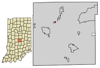
Thorntown is a town in Sugar Creek Township, Boone County, Indiana. The population was 1,520 at the time of the 2010 census. Thorntown is located in northwestern Boone County, about halfway between Lafayette and Indianapolis.

<span class="mw-page-title-main">Ulen, Indiana</span> Town in Indiana, United States

Ulen is a town in Center Township, Boone County, in the U.S. state of Indiana. The population was 117 at the 2010 census. The town is surrounded by the city of Lebanon.

<span class="mw-page-title-main">Mulberry, Indiana</span> Town in Indiana, United States

Mulberry is a town in Madison Township, Clinton County, Indiana, United States. The population was 1,231 at the 2020 census. The town was named for a mulberry tree which grew at the point where it was founded.

<span class="mw-page-title-main">Cumberland, Indiana</span> Town in Indiana, United States

Cumberland is a town in Hancock and Marion counties, Indiana, United States. The population was 5,954 at the 2020 census, up from 5,169 in 2010.

<span class="mw-page-title-main">Wilkinson, Indiana</span> Town in Indiana, United States

Wilkinson is a town in Brown Township, Hancock County, Indiana, United States. The population was 449 at the 2010 census.

<span class="mw-page-title-main">Amo, Indiana</span> Town in Indiana, United States

Amo is a town in Clay Township, Hendricks County, Indiana, United States. The population was 408 at the 2020 census.

<span class="mw-page-title-main">Remington, Indiana</span> Town in Indiana, United States

Remington is a town in Carpenter Township, Jasper County, Indiana, United States. The population was 1,185 at the 2010 census.

<span class="mw-page-title-main">Winona Lake, Indiana</span> Town in Indiana, United States

Winona Lake is a town in Wayne Township, Kosciusko County, in the U.S. state of Indiana, and the major suburb of Warsaw. The population was 4,908 at the 2010 census.

<span class="mw-page-title-main">Edgewood, Indiana</span> Town in Indiana, United States

Edgewood is a town in Anderson Township, Madison County, Indiana, United States. It is part of the Indianapolis–Carmel–Anderson metropolitan statistical area. The population was 2,053 at the 2020 census.

<span class="mw-page-title-main">River Forest, Indiana</span> Town in Indiana, United States

River Forest is a town in Anderson Township, Madison County, Indiana, United States. It is part of the Indianapolis–Carmel–Anderson metropolitan statistical area. The population was 26 at the 2020 census.

<span class="mw-page-title-main">Bloomingdale, Indiana</span> Town in Indiana, United States

Bloomingdale is a town in Penn Township, Parke County, in the U.S. state of Indiana. The population was 335 at the 2010 census.

<span class="mw-page-title-main">Mecca, Indiana</span> Town in Indiana, United States

Mecca is a town in Wabash Township, Parke County, in the U.S. state of Indiana. The population was 335 at the 2010 census.

<span class="mw-page-title-main">Lagro, Indiana</span> Town in Indiana, United States

Lagro is a town in Lagro Township, Wabash County, in the U.S. state of Indiana. The population was 415 at the 2010 census.

<span class="mw-page-title-main">Meridian Hills, Indiana</span> Town in Indiana, United States

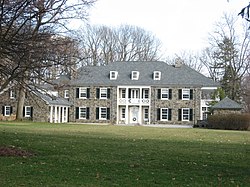
Meridian Hills is a town in Washington Township, Marion County, Indiana, about 8 miles (13 km) north of downtown Indianapolis. It had a population of 1,774 at the 2020 census, up from 1,616 in 2010.

<span class="mw-page-title-main">North Crows Nest, Indiana</span> Town in Indiana, United States

North Crows Nest is a town in Washington Township, Marion County, Indiana, United States. It is approximately 7 miles (11 km) north of downtown Indianapolis. The population was 44 at the 2020 census. It has existed as an "included town" since 1970, when it was incorporated into Indianapolis as part of Unigov. It is part of Indianapolis, but retains town governmental powers under IC 36-3-1-11.

<span class="mw-page-title-main">Spring Hill, Indiana</span> Town in Indiana, United States

Spring Hill is a town in Marion County, Indiana, United States. The population was 95 at the 2020 census. It has existed as an "included town" since 1970, when it was incorporated into Indianapolis as part of Unigov. It is part of Indianapolis, but retains town governmental powers under IC 36-3-1-11.

<span class="mw-page-title-main">Warren Park, Indiana</span> Town in Indiana, United States

Warren Park is a town in Warren Township, Marion County, Indiana, United States. The population was 1,490 at the 2020 census. It has existed as an "included town" since 1970, when it was incorporated into Indianapolis as part of Unigov. It is part of Indianapolis, but retains a functioning town government under IC 36-3-1-11.

Indianapolis (balance) is a statistical entity defined by the United States Census Bureau to represent the portion of the city of Indianapolis, Indiana, that is not within the "included towns". As of the 2020 census the balance had a total population of 887,642.

References

  1. 1 2 "2022 U.S. Gazetteer Files: Indiana". United States Census Bureau. Retrieved April 14, 2023.
  2. 1 2 U.S. Geological Survey Geographic Names Information System: Crows Nest, Indiana
  3. 1 2 "P1. Race – Crows Nest town, Indiana: 2020 DEC Redistricting Data (PL 94-171)". U.S. Census Bureau. Retrieved April 14, 2023.
  4. 1 2 "U.S. Census website". United States Census Bureau . Retrieved January 31, 2008.
  5. "National Register Information System". National Register of Historic Places . National Park Service. July 9, 2010.
  6. Indiana Code 36-3-1
  7. Baker, Ronald L. (October 1995). From Needmore to Prosperity: Hoosier Place Names in Folklore and History . Indiana University Press. pp.  106–107. ISBN   978-0-253-32866-3. ...laid out and incorporated on May 8, 1927, and so named, according to WPA files, because crows nested in a tree here.
  8. "Indiana State Historic Architectural and Archaeological Research Database (SHAARD)" (Searchable database). Department of Natural Resources, Division of Historic Preservation and Archaeology. Retrieved August 1, 2016.Note: This includes Kipp Norman and Paul Baumgarten (March 1999). "National Register of Historic Places Inventory Nomination Form: Town of Crows Nest Historic District" (PDF). Retrieved August 1, 2016., Accompanying photographs, and Accompanying photographs
  9. "Census of Population and Housing". Census.gov. Retrieved June 4, 2015.
  10. "U.S. Census website". United States Census Bureau . Retrieved December 11, 2012.