Fletcher Place

Last updated

Fletcher Place Historic District
Fletcher and Cincinnati in Indianapolis.jpg
Houses on Fletcher Avenue in the neighborhood
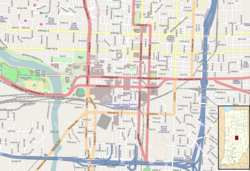
Location map Indianapolis central.png
Red pog.svg
Location map Indianapolis.png
Red pog.svg
USA Indiana location map.svg
Red pog.svg
Usa edcp location map.svg
Red pog.svg
LocationRoughly bounded by railroad tracks, Interstates 65/70, East St., and Virginia Ave., Indianapolis, Indiana
Coordinates 39°45′27″N86°8′46″W / 39.75750°N 86.14611°W / 39.75750; -86.14611
Area40.5 acres (16.4 ha)
Built1855 (1855)
Architectural styleItalianate, Gothic Revival, Queen Anne
NRHP reference No. 82000061 [1]
Added to NRHPFebruary 1, 1982

Fletcher Place is a historic district and neighborhood in the city of Indianapolis, Indiana named after Calvin Fletcher, a prominent local banker, farmer and state senator.

Contents

The neighborhood is clearly defined by I-70/I-65 to the south and East Street to the west. The northern border of the neighborhood is along South Street, Lord Street, Fletcher Avenue, and Bates Street, depending on specific location. The eastern border of the neighborhood is Virginia Avenue in some places, while it is I-65 in a few spots, and Calvary Street in a few areas.

Fletcher Place is surrounded by the Wholesale District to the north, Eli Lilly and Company to the west, Bates-Hendricks neighborhood to the south, and Fountain Square to the east and southeast.

Fletcher Place is the home to a few of Indianapolis' keynote restaurants: Milktooth, Bluebeard, Iaria's Italian, Bosphorus Istanbul Cafe, and Dugout Bar. Additionally, Eli Lilly and Company and Anthem have their world headquarters bordering Fletcher Place, making it a magnet neighborhood for Indianapolis' health-care industry professionals.

Fletcher Place Historic District

The Fletcher Place Historic District is a 40.5-acre (16.4 ha) national historic district in the neighborhood that was listed on the National Register of Historic Places in 1982. [1] In 1982, it included 140 contributing buildings that were deemed to contribute to the historic character of the area. It developed between about 1855 and 1924, and includes representative examples of Italianate, Gothic Revival, and Queen Anne style architecture. Notable buildings include the Briggs Flats (1893), The Lavon Building (c. 1885–1890), Ada Apartments (c. 1900–1910), Fletcher Place Methodist Church, school building (1857 and later), and a gasoline station (1919). [2]

See also

Related Research Articles

<span class="mw-page-title-main">Crows Nest, Indiana</span> Town in Indiana, United States

Crows Nest is a town in Washington Township, Marion County, Indiana, United States, approximately 7 miles (11 km) north of downtown Indianapolis. The population was 67 at the 2020 census. It has existed as an "included town" since 1970, when it was incorporated into Indianapolis as part of Unigov. It is part of Indianapolis, but retains a functioning town government under IC 36-3-1-11.

<span class="mw-page-title-main">Haughville, Indianapolis</span> United States historic place

Haughville is a neighborhood west of downtown Indianapolis. Its borders are roughly White River Parkway to the east, Tibbs Avenue to the west, 16th Street to the north, and Michigan Street to the south. It was first settled in the 1830s and grew after a bridge over White River was built connecting to Indianapolis, which annexed the town in 1897. The modern version of the bridge is also the connection between Haughville on the west side of the river and the Sidney & Lois Eskenazi Hospital and Indiana University - Purdue University Indianapolis on the east. The population in the late 1890s included Slovenian, German, and Irish immigrants, among other European immigrants. In the 21st century, the neighborhood suffers from a high crime rate and low property values.

<span class="mw-page-title-main">Josiah K. Lilly Sr.</span> American businessman

Josiah Kirby Lilly Sr., nicknamed "J. K.," was an American businessman, pharmaceutical industrialist, and philanthropist who became president and chairman of the board of Eli Lilly and Company, the pharmaceutical firm his father, Colonel Eli Lilly, founded in 1876. Josiah, the colonel's sole heir, began working at his father’s company at the age of fourteen. He graduated from the Philadelphia College of Pharmacy and Science and became superintendent of the Lilly laboratories in 1882 and company president in 1898. Under his leadership, the company introduced standardized manufacturing processes, expanded its sales force, and increased its research efforts to develop new drugs. Eli Lilly and Company grew into one of the largest and most influential pharmaceutical corporations in the world, and the largest corporation in Indiana. Lilly’s eldest son, Eli Jr., succeeded him as president in 1932. His younger son, Josiah Jr. ("Joe"), succeeded Eli as company president in 1948. J. K. served as chairman of the board from 1932 until his death in 1948.

<span class="mw-page-title-main">Irvington Historic District (Indianapolis)</span> Historic district in Indiana, United States

The neighborhood of Irvington, named after Washington Irving, includes Irvington Historic District, a historic district in Indianapolis, Indiana. The historic district is a 545-acre (221 ha) area that was listed on the National Register of Historic Places in 1987. That year, the district included 2,373 contributing buildings, 5 other contributing structures, and 2 contributing sites.

<span class="mw-page-title-main">Morris–Butler House</span> Historic house in Indiana, United States

The Morris–Butler House is a Second Empire-style house built about 1864 in the Old Northside Historic District of Indianapolis, Indiana. Restored as a museum home by Indiana Landmarks between 1964 and 1969, the American Civil War-era residence was the non-profit organization's first preservation project. Restoration work retained some of its original architectural features, and the home was furnished in Victorian and Post-Victorian styles. Its use was changed to a venue for Indiana Landmarks programs, special events, and private rentals following a refurbishment in 2013. Regular daily tours of the property have been discontinued.

<span class="mw-page-title-main">Chatham–Arch, Indianapolis</span> United States historic place

Chatham–Arch is a neighborhood located immediately east of Downtown Indianapolis, Indiana, United States. This neighborhood is one of the oldest in Indianapolis, dating back to the mid 19th century. Chatham–Arch contains many of Indianapolis's historic homes.

<span class="mw-page-title-main">Golden Hill Historic District (Indianapolis, Indiana)</span> Historic district in Indiana, United States

Golden Hill is an affluent and historic neighborhood overlooking the White River on the west side of Indianapolis's Center Township, in Marion County, Indiana. The district is bounded on the east by Clifton Street, which is west of Martin Luther King Jr. Boulevard ; on the west by the White River and the Central Canal; on the south by Thirty-sixth Street; and on the north by Woodstock Country Club, immediately south of Thirty-eighth Street. Golden Hill is noted for its collection of homes designed by several of the city's prominent architects. The estate homes reflect several styles of period revival architecture. The district is known as for its community planning and remains an exclusive enclave for the city's prominent families. Golden Hill was added to the National Register of Historic Places in 1991.

<span class="mw-page-title-main">Fountain Square, Indianapolis</span> Neighborhood and cultural district in Indianapolis, Indiana, U.S.

Fountain Square is one of seven designated cultural districts in Indianapolis, Indiana. Located just outside the city's downtown district, Fountain Square is home to three designated national historic districts, the Laurel and Prospect, the State and Prospect, and the Virginia Avenue districts, all of which were listed on the National Register of Historic Places in 1983. The neighborhood derives its name from the successive fountains that have been prominently featured at the intersection of Virginia Avenue, East Prospect Street, and Shelby Street.

The Bates–Hendricks neighborhood is situated just south and east of the downtown commercial district of Indianapolis, Indiana. The Fountain Square business district is just to the east.

<span class="mw-page-title-main">Herron–Morton Place Historic District</span> Historic district in Indiana, United States

Herron–Morton Place is a historic district in Indianapolis, Indiana, United States. The boundaries of the neighborhood are East 16th Street on the south, East 22nd Street on the north, North Pennsylvania Street on the west, and Central Avenue on the east.

<span class="mw-page-title-main">Lockerbie Square Historic District</span> Historic district in Indiana, United States

Lockerbie Square Historic District is a national historic district on the National Register of Historic Places within Indianapolis, Indiana, listed on February 23, 1973, with a boundary increase on July 28, 1987. It is noted for its Federal, Italianate, and Queen Anne style architecture. The original platting of Lockerbie Square, done by Jannett Smith Lockerbie McOuat and named for her father, Scottish immigrant George Murray Lockerbie, was between 1847 and 1850. The 1960s saw an immense effort to save the buildings within the district, becoming the first historic district in Indianapolis. Many of the buildings date from 1855 to 1930. James Whitcomb Riley, famed Hoosier poet, lived in the district for over two decades. He was known to give candy to local children on his regular walks.

<span class="mw-page-title-main">Old Northside Historic District</span> Historic district in Indiana, United States

Old Northside is a residential neighborhood near downtown in Indianapolis, Indiana. It is bordered by 16th Street on the north, Pennsylvania Street on the west, Interstate I-65 on the south, and Bellefontaine Street on the east. The Monon Trail runs along the eastern edge of The Frank and Judy O'Bannon Old Northside Soccer Park.

<span class="mw-page-title-main">North Irvington Gardens Historic District</span> Historic district in Indiana, United States

The North Irvington Gardens Historic District is a neighborhood and national historic district in Indianapolis, Indiana. It was placed on the National Register of Historic Places on June 27, 2008. It is immediately to the north of the Irvington Historic District, which has been on the National Register since 1987, sharing the same east and west boundaries of the older district, and extending north to 10th and 11th streets. It is a neighborhood of mostly residential buildings dating primarily from 1910 to 1950, with no one distinctive architectural style, including a house associated with the historic Osborn Farm. Except for one church, the only buildings contributing to the historic nature of the district are 843 houses and 551 garages. Most fences in the district mark the perimeter of the individual properties; very few are along the streets.

<span class="mw-page-title-main">Washington Park Historic District (Indianapolis, Indiana)</span> Historic district in Indiana, United States

The Washington Park Historic District is a national historic district located in Indianapolis, Indiana. It was listed on the National Register of Historic Places on June 24, 2008. It comprises nearly 60 acres (240,000 m2) and is located 4 miles (6.4 km) north of downtown Indianapolis, in the south-central part of the Meridian-Kessler neighborhood. The district includes all properties south of 43rd Street and north of 40th Street, and west of Central Avenue and east of the alley running north and south between Pennsylvania and Meridian Streets; Washington Boulevard runs north-south through the center of the district. It includes 110 contributing buildings, ranging mostly from mansions to small bungalows, and three non-contributing buildings.

<span class="mw-page-title-main">Oliver Johnson's Woods Historic District</span> Historic district in Indiana, United States

Oliver Johnson's Woods is a historic district and neighborhood on the northern side of Indianapolis, Indiana, United States. Located in southern Washington Township, the district occupies the site of what was once the family farm of Oliver Johnson. Born on the present site of the Indiana State Fairgrounds, Johnson grew up in a pioneer family that lived on the edge of the state capital city. Upon attaining adulthood, he bought property a short distance to the west, to which he moved in 1846. Here, he built a larger farmhouse in 1862, and he tilled the soil for most of the rest of his life. As Indianapolis grew northward, it reached the Johnson farm in the early twentieth century; the aged farmer and his sons saw the city's growth as an opportunity for financial gain, and in 1905 they announced the platting of 0.25 square miles (0.65 km2) of their property into individual lots. They chose an advantageous time to sell their property; as the new residents began to build their homes, an interurban railway was built along College Avenue on the district's western side that connected downtown with Broad Ripple. Many prosperous businessmen were attracted by the development's large lots and wooded streets; the city annexed Oliver Johnson's Woods in 1912, and by the outbreak of World War II, the streets were filled with large houses built in a wide variety of architectural styles. These early residents came from many different ethnicities: European immigrants were becoming more prosperous and leaving their ethnic enclaves, and new neighborhoods such as Oliver Johnson's Woods appealed to them. Among the neighborhood's leading residents was a colony of Jews of German descent.

<span class="mw-page-title-main">Cottage Home Historic District</span> Historic district in Indiana, United States

The Cottage Home Historic District is a historic district and neighborhood located on the near east side of Indianapolis, Indiana. A small portion of Cottage Home is listed on the National Register of Historic Places while a larger area is listed on the state and local levels. Known for its preponderance of "cottage-style" homes built with strong Victorian influences, Cottage Home has historically been a working class neighborhood. Numerous industrial buildings are also scattered throughout the district, providing a base of economic activity. Today, however, many of these buildings are vacant, providing a special challenge to preservation and urban renewal efforts.

<span class="mw-page-title-main">Indianapolis Park and Boulevard System</span> United States historic place

The Indianapolis Park and Boulevard System is a group of parks, parkways, and boulevards in Indianapolis, Indiana, that was designed by landscape architect George Edward Kessler in the early part of the twentieth century. Also known as the Kessler System, the district includes 3,474 acres (1,406 ha) and has shaped the city through the present day. This historic district was added to the National Register of Historic Places in 2003.

<span class="mw-page-title-main">Emerson Avenue Addition Historic District</span> Historic district in Indiana, United States

Emerson Avenue Addition Historic District, also known as Emerson Heights Addition and Charles M. Cross Trust Clifford Avenue Addition, is a national historic district located at Indianapolis, Indiana. It encompasses 1,000 contributing buildings and 9 contributing objects in a planned residential section of Indianapolis. The district developed between about 1910 and 1949, and includes representative examples of Tudor Revival, Colonial Revival, and Bungalow / American Craftsman style residential architecture.

<span class="mw-page-title-main">Washington Street–Monument Circle Historic District</span> Historic district in Indiana, United States

Washington Street–Monument Circle Historic District is a national historic district located at Indianapolis, Indiana, United States, covering the first two blocks of East and West Washington and Market streets, the south side of the 100 block of East Ohio Street, Monument Circle, the first block of North and South Meridian Street, the first two blocks of North Pennsylvania Street, the west side of the first two blocks of North Delaware Street, the east side of the first block of North Capitol Avenue, and the first block of North Illinois Street. In total, the district encompasses 40 contributing buildings and 2 contributing structures in the central business district of Indianapolis centered on Monument Circle. It developed between about 1852 and 1946, and includes representative examples of Italianate, Greek Revival, and Art Deco style architecture.

<span class="mw-page-title-main">St. Joseph Neighborhood Historic District</span> Historic district in Indiana, United States

St. Joseph Neighborhood Historic District is a national historic district located at Indianapolis, Indiana. The district encompasses 57 contributing buildings in a predominantly residential section of Indianapolis. It was developed between about 1855 and 1930, and include representative examples of Italianate and Queen Anne style architecture. Located in the district are the separately listed Bals-Wocher House, William Buschmann Block, Delaware Court, Pearson Terrace, and The Spink. Other notable buildings include the Christian Place complex, Fishback-Vonnegut-New House, Henry Hilker House, Apollo-Aurora Rowhouses, Israel Traub Store, and Lorenzo Moody House.

References

  1. 1 2 "National Register Information System". National Register of Historic Places . National Park Service. July 9, 2010.
  2. "Indiana State Historic Architectural and Archaeological Research Database (SHAARD)" (Searchable database). Department of Natural Resources, Division of Historic Preservation and Archaeology. Retrieved August 1, 2016.Note: This includes Michael F. Crowe; Mary King; Judith Burd (November 1979). "National Register of Historic Places Inventory Nomination Form: Fletcher Place Historic District" (PDF). Retrieved August 1, 2016. and Accompanying photographs