Morristown, Indiana

Last updated

Morristown, Indiana
Morristown, Indiana.jpg
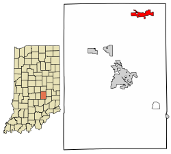
Shelby County Indiana Incorporated and Unincorporated areas Morristown Highlighted 1851192.svg
Location of Morristown in Shelby County, Indiana.
Coordinates: 39°40′26″N85°42′18″W / 39.67389°N 85.70500°W / 39.67389; -85.70500
Country United States
State Indiana
County Shelby
Township Hanover
Area
[1]
  Total2.52 sq mi (6.52 km2)
  Land2.50 sq mi (6.47 km2)
  Water0.02 sq mi (0.05 km2)
Elevation
[2]
820 ft (250 m)
Population
 (2020)
  Total1,205
  Density482.39/sq mi (186.23/km2)
Time zone UTC-5 (Eastern (EST))
  Summer (DST) UTC-4 (EDT)
ZIP code
46161
Area code 765
FIPS code 18-51192 [3]
GNIS feature ID2396783 [2]
Website http://www.morristown.in.gov/

Morristown is a town in Hanover Township, Shelby County, in the U.S. state of Indiana. [2] The population was 1,218 at the 2010 census.

Contents

History

Morristown was platted in 1828 by Samuel Morrison, and named for him. [4] The Morristown post office has been in operation since 1834. [5]

Junction Railroad Depot was listed on the National Register of Historic Places in 1979. [6]

Geography

According to the 2010 census, Morristown has a total area of 2.37 square miles (6.14 km2), of which 2.35 square miles (6.09 km2) (or 99.16%) is land and 0.02 square miles (0.05 km2) (or 0.84%) is water. [7]

Demographics

Historical population
CensusPop.Note
1880 375
1890 56149.6%
1900 5650.7%
1910 62210.1%
1920 6585.8%
1930 608−7.6%
1940 6659.4%
1950 6792.1%
1960 7043.7%
1970 83819.0%
1980 98918.0%
1990 980−0.9%
2000 1,13315.6%
2010 1,2187.5%
2020 1,205−1.1%
U.S. Decennial Census [8]
The Junction Railroad Depot in Morristown is listed on the National Register of Historic Places Junction Railroad Depot, eastern end and southern side.jpg
The Junction Railroad Depot in Morristown is listed on the National Register of Historic Places

2010 census

As of the census [9] of 2010, there were 1,218 people, 467 households, and 311 families living in the town. The population density was 518.3 inhabitants per square mile (200.1/km2). There were 519 housing units at an average density of 220.9 per square mile (85.3/km2). The racial makeup of the town was 98.6% White, 0.1% African American, 0.7% Native American, 0.1% Asian, and 0.6% from two or more races. Hispanic or Latino of any race were 1.3% of the population.

There were 467 households, of which 36.2% had children under the age of 18 living with them, 43.0% were married couples living together, 18.0% had a female householder with no husband present, 5.6% had a male householder with no wife present, and 33.4% were non-families. 29.6% of all households were made up of individuals, and 12.3% had someone living alone who was 65 years of age or older. The average household size was 2.41 and the average family size was 2.95.

The median age in the town was 38 years. 24.7% of residents were under the age of 18; 8% were between the ages of 18 and 24; 24.9% were from 25 to 44; 21.4% were from 45 to 64; and 20.9% were 65 years of age or older. The gender makeup of the town was 45.4% male and 54.6% female.

2000 census

As of the census [3] of 2000, there were 1,133 people, 426 households, and 296 families living in the town. The population density was 1,182.2 inhabitants per square mile (456.4/km2). There were 444 housing units at an average density of 463.3 per square mile (178.9/km2). The racial makeup of the town was 98.94% White, 0.53% Native American, 0.09% Asian, and 0.44% from two or more races. Hispanic or Latino of any race were 0.53% of the population.

There were 426 households, out of which 38.3% had children under the age of 18 living with them, 55.4% were married couples living together, 10.6% had a female householder with no husband present, and 30.3% were non-families. 27.9% of all households were made up of individuals, and 13.8% had someone living alone who was 65 years of age or older. The average household size was 2.58 and the average family size was 3.12.

In the town, the population was spread out, with 28.0% under the age of 18, 9.1% from 18 to 24, 29.0% from 25 to 44, 18.2% from 45 to 64, and 15.7% who were 65 years of age or older. The median age was 35 years. For every 100 females, there were 89.1 males. For every 100 females age 18 and over, there were 84.6 males.

The median income for a household in the town was $36,417, and the median income for a family was $44,327. Males had a median income of $32,625 versus $23,295 for females. The per capita income for the town was $16,129. About 2.4% of families and 5.5% of the population were below the poverty line, including 5.2% of those under age 18 and 9.7% of those age 65 or over.
Education

Morristown is the location of Morristown Elementary and Morristown Junior-Senior High School.

Morristown has a public library, a branch of the Shelby County Public Library. [10]

Related Research Articles

<span class="mw-page-title-main">Ashland, Illinois</span> Village in Illinois, United States

Ashland is a village in Cass County, Illinois, United States. The population was 1,218 at the 2020 census.

<span class="mw-page-title-main">St. Paul, Indiana</span> Town in Indiana, United States

St. Paul or Saint Paul is a small town on the border of Decatur and Shelby counties in the U.S. state of Indiana. The population was 1,031 at the 2010 census.

<span class="mw-page-title-main">Wheatland, Indiana</span> Town in Indiana, United States

Wheatland is a town in Steen Township, Knox County, Indiana, United States. The population was 480 at the 2010 census.

<span class="mw-page-title-main">Parker City, Indiana</span> Town in Indiana, United States

Parker City is a town in Monroe Township, Randolph County, in the U.S. state of Indiana. The population was 1,419 at the 2010 census.

<span class="mw-page-title-main">Tennant, Iowa</span> City in Iowa, United States

Tennant is a city in Shelby County, Iowa, United States. The population was 78 at the time of the 2020 census.

<span class="mw-page-title-main">Stockbridge, Michigan</span> Village in Michigan, United States

Stockbridge is a village in Ingham County in the U.S. state of Michigan. It is located within Stockbridge Township about 36 miles (58 km) southeast from downtown Lansing. The population was 1,218 at the 2010 census.

<span class="mw-page-title-main">Shelby, Oceana County, Michigan</span> Village in Michigan, United States

Shelby is a village in Oceana County in the U.S. state of Michigan. The population was 2,065 at the 2010 census.

<span class="mw-page-title-main">Waterville, Minnesota</span> City in Minnesota, United States

Waterville is a town in Le Sueur County, Minnesota, United States. The population was 1,868 at the 2010 census. It is close to Sakatah Lake State Park on the Cannon River.

<span class="mw-page-title-main">Morristown, Minnesota</span> City in Minnesota, United States

Morristown is a city in Rice County, Minnesota, United States. The population was 949 at the 2020 census.

Morristown Township is a township in Rice County, Minnesota, United States. The population was 665 at the 2000 census.

<span class="mw-page-title-main">Shelbyville, Missouri</span> City in Missouri, United States

Shelbyville is a city in Shelby County, Missouri, United States. The population was 518 at the 2020 census. It is the county seat of Shelby County.

<span class="mw-page-title-main">Mount Hope, New York</span> Town in New York, United States

Mount Hope is a town in the northwestern part of Orange County, New York, United States, west of Middletown. The northern town line is the border of Sullivan County. The population was 6,537 at the 2020 census.

<span class="mw-page-title-main">Indian Beach, North Carolina</span> Town in North Carolina, United States

Indian Beach is a town in Carteret County, North Carolina, United States. The population was 223 as of the 2020 census.

<span class="mw-page-title-main">Morristown, Ohio</span> Village in Ohio, United States

Morristown is a village in Belmont County, Ohio, United States. The population was 248 at the 2020 census. It is part of the Wheeling metropolitan area.

<span class="mw-page-title-main">Botkins, Ohio</span> Village in Ohio, United States

Botkins is a village in Shelby County, Ohio, United States. The population was 1,155 at the 2020 census.

<span class="mw-page-title-main">Port Jefferson, Ohio</span> Village in Ohio, United States

Port Jefferson is a village in Salem Township, Shelby County, Ohio, United States. The population was 308 at the 2020 census.

<span class="mw-page-title-main">Jefferson Township, Washington County, Pennsylvania</span> Township in Pennsylvania, United States

Jefferson Township is a township in Washington County, Pennsylvania, United States. The population was 1,116 at the 2020 census.

<span class="mw-page-title-main">Morristown, South Dakota</span> Town in South Dakota, United States

Morristown is a town in Corson County, South Dakota, United States. The population was 67 at the 2010 census.

<span class="mw-page-title-main">Morristown, Vermont</span> Town in Vermont, United States

Morristown is a town in Lamoille County, Vermont, United States. As of the 2020 census, the population was 5,434. Morristown is the largest town by population in Lamoille County, and its central village of Morrisville serves as the county's main commercial center.

<span class="mw-page-title-main">Shelby, Wisconsin</span> Town in Wisconsin, United States

Shelby is a town in La Crosse County, Wisconsin, United States. It is part of the La Crosse, Wisconsin Metropolitan Statistical Area. The population was 4,715 at the 2010 census. The unincorporated community of Shelby is located in the town.

References

  1. "2020 U.S. Gazetteer Files". United States Census Bureau. Retrieved March 16, 2022.
  2. 1 2 3 U.S. Geological Survey Geographic Names Information System: Morristown, Indiana
  3. 1 2 "U.S. Census website". United States Census Bureau . Retrieved January 31, 2008.
  4. Chadwick, Edward H. (1909). Chadwick's History of Shelby County, Indiana. B.F. Bowen. p. 274.
  5. "Shelby County". Jim Forte Postal History. Retrieved November 8, 2016.
  6. "National Register Information System". National Register of Historic Places . National Park Service. July 9, 2010.
  7. "G001 - Geographic Identifiers - 2010 Census Summary File 1". United States Census Bureau. Archived from the original on February 13, 2020. Retrieved July 17, 2015.
  8. "Census of Population and Housing". Census.gov. Retrieved June 4, 2015.
  9. "U.S. Census website". United States Census Bureau . Retrieved December 11, 2012.
  10. "Locations". Shelby County Public Library. Retrieved March 15, 2018.