Cumberland, Indiana | |
---|---|
Coordinates: 39°47′04″N85°56′45″W / 39.78444°N 85.94583°W | |
Country | United States |
State | Indiana |
Counties | Hancock, Marion |
Area | |
• Total | 2.82 sq mi (7.30 km2) |
• Land | 2.81 sq mi (7.28 km2) |
• Water | 0.01 sq mi (0.02 km2) |
Elevation | 833 ft (254 m) |
Population | |
• Total | 5,954 |
• Density | 2,118.11/sq mi (817.93/km2) |
Time zone | UTC-5 (EST) |
• Summer (DST) | UTC-4 (EST) |
ZIP code | 46229 |
Area code | 317 |
FIPS code | 18-16336 [4] |
GNIS feature ID | 2396672 [2] |
Website | www |
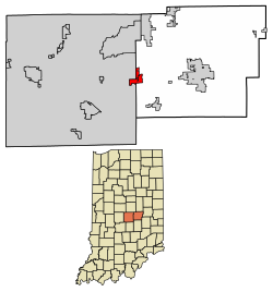
Cumberland is a town in Hancock and Marion counties, Indiana, United States. The population was estimated to be at 6,419 as of the 2023 census [5] up from 5,169 in 2010.
Cumberland was founded in the 1830s when the Cumberland Road (also known as the National Road) was extended to that point. [6] [7] Cumberland contained a post office from 1834 until it was discontinued in 1958. [8] Since 1970, the Marion County portion of Cumberland has been subject to Unigov as an included town. [9] [10]
The center of Cumberland is in eastern Marion County, but the town limits extend east and north into western Hancock County, so that the majority of the town's area is now in Hancock County. U.S. Route 40, following the route of the National Road, is the main road through the community, leading west 10 miles (16 km) to downtown Indianapolis and east the same distance to Greenfield, the Hancock county seat.
According to the U.S. Census Bureau, the town has a total area of 2.82 square miles (7.3 km2), of which 0.01 square miles (0.026 km2), or 0.35%, are water. [1] Buck Creek crosses the town, flowing south to join Sugar Creek near London. The town is part of the watershed of the East Branch of the White River.
Census | Pop. | Note | %± |
---|---|---|---|
1880 | 299 | — | |
1960 | 872 | — | |
1970 | 1,478 | 69.5% | |
1980 | 3,375 | 128.3% | |
1990 | 4,557 | 35.0% | |
2000 | 5,500 | 20.7% | |
2010 | 5,169 | −6.0% | |
2020 | 5,954 | 15.2% | |
U.S. Decennial Census [11] |
As of the census [12] of 2010, there were 5,169 people, 1,972 households, and 1,422 families living in the town. The population density was 2,509.2 inhabitants per square mile (968.8/km2). There were 2,233 housing units at an average density of 1,084.0 per square mile (418.5/km2). The racial makeup of the town was 77.0% White, 16.8% African American, 0.6% Native American, 0.9% Asian, 0.1% Pacific Islander, 2.3% from other races, and 2.3% from two or more races. Hispanic or Latino of any race were 5.3% of the population.
There were 1,972 households, of which 36.4% had children under the age of 18 living with them, 50.3% were married couples living together, 16.6% had a female householder with no husband present, 5.2% had a male householder with no wife present, and 27.9% were non-families. 23.1% of all households were made up of individuals, and 6.8% had someone living alone who was 65 years of age or older. The average household size was 2.61 and the average family size was 3.05.
The median age in the town was 38.4 years. 27.4% of residents were under the age of 18; 7.8% were between the ages of 18 and 24; 24% were from 25 to 44; 29.3% were from 45 to 64; and 11.5% were 65 years of age or older. The gender makeup of the town was 48.1% male and 51.9% female.
As of the census [4] of 2000, there were 5,500 people, 2,030 households, and 1,565 families living in the town. The population density was 2,907.0 inhabitants per square mile (1,122.4/km2). There were 2,190 housing units at an average density of 1,157.5 per square mile (446.9/km2). The racial makeup of the town was 85.20% White, 10.56% African American, 0.22% Native American, 1.76% Asian, 0.04% Pacific Islander, 0.75% from other races, and 1.47% from two or more races. Hispanic or Latino of any race were 1.45% of the population.
There were 2,030 households, out of which 40.6% had children under the age of 18 living with them, 59.3% were married couples living together, 14.6% had a female householder with no husband present, and 22.9% were non-families. 19.1% of all households were made up of individuals, and 5.7% had someone living alone who was 65 years of age or older. The average household size was 2.70 and the average family size was 3.08.
In the town, the population was spread out, with 30.0% under the age of 18, 7.1% from 18 to 24, 29.9% from 25 to 44, 24.4% from 45 to 64, and 8.6% who were 65 years of age or older. The median age was 34 years. For every 100 females, there were 92.5 males. For every 100 females age 18 and over, there were 88.1 males.
The median income for a household in the town was $57,875, and the median income for a family was $61,739. Males had a median income of $48,750 versus $28,239 for females. The per capita income for the town was $24,746. About 5.0% of families and 6.6% of the population were below the poverty line, including 12.2% of those under age 18 and 1.5% of those age 65 or over.
Marion County is located in the U.S. state of Indiana. The 2020 United States census reported a population of 977,203, making it the 54th-most populous county in the U.S., the most populous county in the state, and the main population center of the 11-county Indianapolis–Carmel–Greenwood MSA in central Indiana. Indianapolis is the county seat, the state capital, and most populous city. Marion County is consolidated with Indianapolis through an arrangement known as Unigov.
Matthews is a town in Jefferson Township, Grant County, Indiana, United States, along the Mississinewa River. The population was 596 at the 2010 census.
Upland is a town in Jefferson Township, Grant County, Indiana, United States. The population was 3,821 at the 2020 census. It is the home of Taylor University, a Christian college.
Fortville is a town in Vernon Township, Hancock County, Indiana, United States. The population was 4,784 at the 2020 census.
McCordsville is a town in Vernon Township, Hancock County, Indiana, United States. The town is a fast-growing suburb of Indianapolis with an estimated population of 8,592 in 2020.
Wilkinson is a town in Brown Township, Hancock County, Indiana, United States. The population was 449 at the 2010 census.
Ingalls is a town in Green Township, Madison County, Indiana, United States. It is part of the Indianapolis–Carmel–Anderson metropolitan statistical area. The population was 2,223 at the 2020 census.
Lawrence is a city in Marion County, Indiana, United States. It is one of four "excluded cities" in Marion County. The city is home to Fort Benjamin Harrison within Fort Harrison State Park. The population was 49,370 at the 2020 census. The city is on the northeast side of Indianapolis.
Southport is an excluded city in Marion County, Indiana, United States. The population was 2,123 at the 2020 census, up from 1,712 in 2010.
Speedway is a town in Wayne Township, Marion County, Indiana, United States. The population was 13,952 at the 2020 census, up from 11,812 in 2010. Speedway, which is an enclave of Indianapolis, is the home of the Indianapolis Motor Speedway.
Meridian Hills is a town in Washington Township, Marion County, Indiana, about 8 miles (13 km) north of downtown Indianapolis. It had a population of 1,774 at the 2020 census, up from 1,616 in 2010.
North Crows Nest is a town in Washington Township, Marion County, Indiana, United States. It is approximately 7 miles (11 km) north of downtown Indianapolis. The population was 44 at the 2020 census. It has existed as an "included town" since 1970, when it was incorporated into Indianapolis as part of Unigov. It is part of Indianapolis, but retains town governmental powers under IC 36-3-1-11.
Rocky Ripple is a town in Marion County, Indiana, United States. The population was 655 at the 2020 census. It was founded in 1927, and the town was incorporated as an "included town" as part of Unigov in 1970. It is part of Indianapolis, but retains a separate functioning town government under IC 36-3-1-11. Although not far from the city center, Rocky Ripple is a somewhat isolated area, located between the Central Canal and the White River; only two traffic-supporting bridges over the canal provide access to the town.
Spring Hill is a town in Marion County, Indiana, United States. The population was 95 at the 2020 census. It has existed as an "included town" since 1970, when it was incorporated into Indianapolis as part of Unigov. It is part of Indianapolis, but retains town governmental powers under IC 36-3-1-11.
Warren Park is a town in Warren Township, Marion County, Indiana, United States. The population was 1,490 at the 2020 census. It has existed as an "included town" since 1970, when it was incorporated into Indianapolis as part of Unigov. It is part of Indianapolis, but retains a functioning town government under IC 36-3-1-11.
Williams Creek is a town in Washington Township, Marion County, Indiana, United States. It is located about 9 miles (14 km) north of downtown Indianapolis. The population was 430 at the 2020 census. It has existed as an "included town" since 1970, when it was incorporated into Indianapolis as part of Unigov. It is part of Indianapolis, but retains a functioning town government under IC 36-3-1-11.
Wynnedale is a town in Washington Township, Marion County, Indiana, United States. The population was 215 at the 2020 census. It has existed as an "included town" since 1970, when it was incorporated into Indianapolis as part of Unigov. It is part of Indianapolis, but retains a functioning town government under IC 36-3-1-11.
Crows Nest is a town in Washington Township, Marion County, Indiana, United States, approximately 7 miles (11 km) north of downtown Indianapolis. The population was 67 at the 2020 census. It has existed as an "included town" since 1970, when it was incorporated into Indianapolis as part of Unigov. It is part of Indianapolis, but retains a functioning town government under IC 36-3-1-11.
Homecroft is a town in Perry Township, Marion County, Indiana, United States. The population was 752 at the 2020 census. Incorporated in 1949, it has existed as an included town since 1970, when it was incorporated into Indianapolis as part of Unigov. It is part of Indianapolis, but retains a functioning town government under IC 36-3-1-11.
Indianapolis (balance) is a statistical entity defined by the United States Census Bureau to represent the portion of the city of Indianapolis, Indiana, that is not within the "included towns". As of the 2020 census the balance had a total population of 887,642.
...and named for the Cumberland Road, on which it was located.