Franklin Township, Marion County, Indiana

Last updated
Franklin Township
Marion County
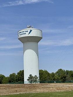
Franklin Township water tower - May 2022 - Sarah Stierch.jpg
Franklin Township's water tower in 2022.
Map highlighting Franklin Township, Marion County, Indiana.svg
Coordinates: 39°40′49″N86°1′39″W / 39.68028°N 86.02750°W / 39.68028; -86.02750 Coordinates: 39°40′49″N86°1′39″W / 39.68028°N 86.02750°W / 39.68028; -86.02750
Country United States
State Indiana
County Marion
Named for Benjamin Franklin
Government
  Type Indiana township
Area
  Total42.1 sq mi (109.1 km2)
  Land42.1 sq mi (109.1 km2)
  Water0.0 sq mi (0.0 km2)
Elevation
837 ft (255 m)
Population
 (2020)
  Total65,788
  Density1,600/sq mi (600/km2)
Time zone UTC-5 (Eastern (EST))
  Summer (DST) UTC-4 (EDT)
ZIP Codes
46107, 46203, 46237, 46239, 46259
Area code 317
FIPS code 18-25504 [1]
GNIS feature ID0453308 [2]

Franklin Township is one of the nine townships of Marion County, Indiana, United States. Located in the southeast corner of the county, it has been subsumed into the city of Indianapolis along with most of the rest of the county. It contains the communities of Acton, Wanamaker, and the eastern portion of the excluded city of Beech Grove.

Contents

Franklin Township was organized in the 1820s. [3] Franklin Township is one of the last areas in Marion County to see heavy suburban land development from the outward expansion of Indianapolis. This is primarily because of a history of family farms in the area, but is also due to various civic efforts to maintain a rural atmosphere in the area over time.

The population of the township as of the 2020 census was 65,788 [4] up from 32,080 in 2000. [5] The twofold increase in population ranks Franklin Township as the fastest growing of Marion County's nine townships during that timeframe.

The township has a median income of $70,000. [6]

Education

Franklin Township Community School Corporation is the public school district that serves all of Franklin Township. The area high school is Franklin Central High School.

In recent years, Franklin Township has seen a population explosion leading to a heavy reliance on residential property taxes in particular for funding of the Franklin Township Community Schools. Also, as the Indiana Property Tax caps have been phased in from 2008 to 2011, revenue for the schools in the township has dropped more than 19.8%. [7] After two referendums failed to close the $13 million gap in school funding, the school board proposed cuts to close the gap, including cutting teachers and halting most student busing. [8] The shortfall is larger in Franklin Township because of the demographics being extensively residential, while the tax burden with the aforementioned property tax caps has shifted more to farms and businesses which now have a capped rate of 2% and 3% respectively.

In 2012, the Franklin Township School Corporation was able to again offer student bussing without additional fees by restructuring its debt.

Local media

Newspapers

Radio

State legislators

The following legislators represent the districts which contain parts of Franklin Township.

Indiana House

RepresentativePartyDistrict
Mitch Gore Democratic 89
Michael Speedy Republican 90

Indiana Senate

SenatorPartyDistrict
Aaron Freeman Republican 32

Geography

Municipalities

Communities

Related Research Articles

<span class="mw-page-title-main">Indianapolis</span> Capital and largest city in Indiana, United States

Indianapolis, colloquially known as Indy, is the state capital and most populous city of the U.S. state of Indiana and the seat of Marion County. According to the U.S. Census Bureau, the consolidated population of Indianapolis and Marion County was 977,203 in 2020. The "balance" population, which excludes semi-autonomous municipalities in Marion County, was 887,642. It is the 15th most populous city in the U.S., the third-most populous city in the Midwest, after Chicago and Columbus, Ohio, and the fourth-most populous state capital after Phoenix, Arizona, Austin, Texas, and Columbus. The Indianapolis metropolitan area is the 33rd most populous metropolitan statistical area in the U.S., with 2,111,040 residents. Its combined statistical area ranks 28th, with a population of 2,431,361. Indianapolis covers 368 square miles (950 km2), making it the 18th largest city by land area in the U.S.

<span class="mw-page-title-main">Montgomery County, Indiana</span> County in Indiana, United States

Montgomery County is a county in the U.S. state of Indiana. As of the 2020 United States census, it had a population of 37,936. Its county seat is Crawfordsville. The county is divided into eleven townships which provide local services.

<span class="mw-page-title-main">Newton County, Indiana</span> County in Indiana, United States

Newton County is a county located near the northwestern corner of the U.S. state of Indiana. As of 2010, the population was 14,244. This county is part of Northwest Indiana as well as the Chicago metropolitan area. The county seat is Kentland. The county is divided into 10 townships which provide local services.

<span class="mw-page-title-main">Morgan County, Indiana</span> County in Indiana, United States

Morgan County is a county located in the U.S. state of Indiana. As of the 2010 United States Census, the population was 68,894. The county seat is Martinsville.

<span class="mw-page-title-main">Marion County, Indiana</span> County in Indiana, United States

Marion County is located in the U.S. state of Indiana. The 2020 United States census reported a population of 977,203, making it the largest county in the state and 51st most populated county in the country. Indianapolis is the county seat, the state capital, and largest city. Marion County is consolidated with Indianapolis through an arrangement known as Unigov.

<span class="mw-page-title-main">Johnson County, Indiana</span> County in Indiana, United States

Johnson County is a county located in the U.S. state of Indiana. As of 2020, the population was 161,765. The county seat is Franklin.

<span class="mw-page-title-main">Franklin County, Indiana</span> County in Indiana, United States

Franklin County is a county on the eastern border of the U.S. state of Indiana. In the 2020 United States Census, the county population was 22,785. The county seat is the town of Brookville. Franklin County is part of the Cincinnati, OH–KY–IN Metropolitan Statistical Area. The only incorporated city in Franklin County is Batesville, which lies mostly in adjoining Ripley County.

<span class="mw-page-title-main">Boone County, Indiana</span> County in Indiana, United States

Boone County is a county in the U.S. state of Indiana. As of 2020, the population was 70,812. The county seat is Lebanon.

<span class="mw-page-title-main">Greenwood, Indiana</span> City in Indiana, United States

Greenwood is a city in Johnson County, Indiana, United States. The population was 63,830 at the 2020 Census. Greenwood is located southeast of central Indianapolis between Indiana State Road 37 and Interstate 65. The city shares a border with Indianapolis and is the most populous suburban municipality in the southern portion of the Indianapolis Metropolitan Area.

<span class="mw-page-title-main">Beech Grove, Indiana</span> City in Indiana, United States

Beech Grove is a city in Marion County, Indiana, United States. As of the 2020 census, the city's population is 14,717. The city is located within the Indianapolis metropolitan area. Beech Grove is designated an "excluded city" under Indiana law, as it is not part of the consolidated government of Indianapolis and Marion County.

<span class="mw-page-title-main">Unigov</span> Consolidated government of Indianapolis and Marion County in Indiana, U.S.

Unigov is the colloquial name adopted by the city of Indianapolis, Indiana, to describe its consolidated city–county government. By an act of the Indiana General Assembly, Indianapolis consolidated with the government of Marion County in 1970.

<span class="mw-page-title-main">Perry Township, Marion County, Indiana</span> Township in Indiana, United States

Perry Township is one of the nine townships of Marion County, Indiana, United States, located in the south central part of the county. It was laid out in 1822 by the U.S. Army Corps of Engineers and named after Oliver Hazard Perry – a War of 1812 hero. The township population was 108,972 at the 2010 census. This includes the largest community of Burmese-Americans in the United States, numbering over 24,000. Through the White River, Perry and Decatur townships share the only water boundary among Marion County's townships.

<span class="mw-page-title-main">Wanamaker, Indiana</span> Neighborhood in Indianapolis, Indiana, U.S.

Wanamaker is a community of Indianapolis located in southeastern Marion County, Indiana. It is situated 9 miles (14 km) southeast of downtown Indianapolis in north central Franklin Township. The community is concentrated near the intersection of Southeastern Avenue and Northeastern Avenue. The town was built along the historic Michigan Road.

<span class="mw-page-title-main">Indiana's 6th congressional district</span> U.S. House district for Indiana

Indiana's 6th congressional district is a congressional district in the U.S. state of Indiana. The district takes in a portion of eastern and central Indiana as of the 2020 census, including Columbus and Richmond, some of Cincinnati's Indiana suburbs, most of Indianapolis' southern suburbs, and a sliver of Indianapolis itself.

<span class="mw-page-title-main">Indianapolis Public Library</span> Public library system in Marion County, Indiana, U.S.

The Indianapolis Public Library (IndyPL), formerly known as the Indianapolis–Marion County Public Library, is the public library system serving the citizens of Marion County, Indiana, United States and its largest city, Indianapolis. The library was founded in 1873 and has grown to include a Central Library building, located adjacent to the Indiana World War Memorial Plaza, and 24 branch libraries spread throughout the county.

<span class="mw-page-title-main">Center Township, Marion County, Indiana</span> Township in Indiana, United States

Center Township is one of nine townships in Marion County, Indiana, in the United States. As of the 2010 census, its population was 142,787 and it contained 76,872 housing units. It is the most populated township in Marion County.

<span class="mw-page-title-main">Warren Township, Marion County, Indiana</span> Township in Indiana, United States

Warren Township is one of nine townships in Marion County, Indiana. As of the 2010 census, its population was 99,433. Warren Township was named for Joseph Warren.

The Indianapolis Fire Department (IFD) provides fire and rescue protection and emergency medical services to the city of Indianapolis, Indiana. In total the department serves 278 square miles (720 km2).

References

  1. "U.S. Census website". United States Census Bureau . Retrieved 2008-01-31.
  2. "US Board on Geographic Names". United States Geological Survey. 2007-10-25. Retrieved 2008-01-31.
  3. Bodenhamer, David J.; Barrows, Robert G. (22 November 1994). The Encyclopedia of Indianapolis. Indiana University Press. p. 598. ISBN   0-253-11249-4.
  4. "Franklin township, Marion County, IN". Census Reporter. 1 April 2020. Retrieved 21 October 2022.
  5. "Profile of General Population and Housing Characteristics: 2000 Demographic Profile Data (DP-1): Franklin township, Marion County, Indiana". United States Census Bureau . Retrieved February 13, 2012.
  6. "Median income".
  7. "Franklin Township Community School Corporation Cash Flow Analysis Summary" (PDF). Franklin Township Community School Corporation . Retrieved 2011-04-22.
  8. "Franklin Township school district faces $13M shortfall". WTHR . Retrieved 2011-04-22.