Northwest Indiana, commonly referred to as "The Region" after the Calumet Region,[1] is an unofficial geographic area in the northwestern corner of Indiana in the United States. Although its boundaries are not formally defined, the area is generally associated with the Gary, Indiana Metropolitan Division, which includes Jasper, Lake, Porter and Newton counties, and the Michigan City–La Porte Metropolitan Statistical Area, which includes LaPorte County,[2] with some broader definitions also including Starke and Pulaski counties.[3]
Jasper, Lake, LaPorte, Newton and Porter counties are included in the Chicago–Naperville–Michigan City Combined Statistical Area, the broadest census-defined designation for the Chicago metropolitan area. Unlike most of Indiana, which is in the Eastern Time Zone, these counties and Starke County are in the Central Time Zone; Pulaski County is the only county in the broader definitions of Northwest Indiana that is in the Eastern Time Zone. The time zone alignment reflects the area's economic connections with the Chicago metropolitan area.
Lake, Porter, and LaPorte counties are served by the Northwestern Indiana Regional Planning Commission, the metropolitan planning organization for the area.[7]
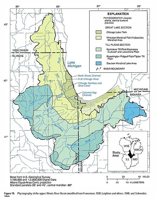
The Chicago Lake Plain encompasses the relatively flat northern portion of Northwest Indiana located north of the morainal system. The plain consists of glaciolacustrine deposits that formed under the waters of glacial Lake Michigan. This lake developed as glaciers melted north of the Valparaiso Moraine. Overflow through a low point on the moraine at the Chicago Outlet in the present-day southwestern Chicago suburbs lowered the lake to approximately its modern level (Horsley, 1986).[10] As the lake receded, it left a series of sand ridges marking former shorelines. Along the Lake Michigan coast, prevailing winds formed additional dune ridges, creating variation within the originally flat surface of the lake plain.
Wheaton Morainal Plain
Physiography of the Upper Illinois River Basin
South of the Chicago Lake Plain, covering central parts of Lake and Porter counties and northern LaPorte County, lies the hilly Wheaton Morainal Plain. This plain includes the Valparaiso Moraine and Tinley Moraine, which run roughly parallel to the Lake Michigan shoreline. The Wheaton Morainal Plain is composed of rolling moraines from the Wisconsin glaciation and consists of clayey till, sandy and loamy till, with localized deposits of sand and gravel. Additional sediments include lake clay, silt, and alluvium. Thicknesses of these deposits range between 50 and 200ft (15 and 61m), with some southern areas exceeding 200 ft of till (Mades, 1987).[11]
Kankakee Outwash Plain
The Kankakee Outwash Plain, located in southern Lake, Porter, and LaPorte counties, is a flat outwash plain formed by meltwater from glaciers halted at the Valparaiso Moraine (Mickelson et al., 1984). The deposits are primarily sand and gravel, with additional layers of alluvium and fill material. Deposit thickness generally averages less than 200ft (61m), ranging from under 50ft (15m) in lowland areas to more than 200 ft in upland areas. Local elevation variations are typically less than 100ft (30m),[11] and the plain includes numerous scattered sand dunes.
Bloomington Ridged Plain
The Bloomington Ridged Plain occupies the southernmost portion of Northwest Indiana, in the Iroquois River valley of southern Newton and Jasper counties. The area is characterized by low, rolling hills, including moraines such as the Iroquois Moraine, with elevation changes of less than 300ft (91m). Soils in the region consist of loamy till, lake clay, and silt. These deposits were left by the northeastward retreat of the Huron-Erie glacial lobe, in contrast to the northern half of Northwest Indiana. Thickness of the deposits is generally less than 200ft (61m), though some areas exceed 400ft (120m).[12]
Economy
In 2015, Northwest Indiana had a gross domestic product of $28.64 billion, representing approximately nine percent of Indiana's total gross state product. This placed the region second among Indiana metropolitan areas, after Indianapolis, and 89th in the United States, comparable to the GDP of the El Paso, Texas, metropolitan area.[13]
The northern portion of Northwest Indiana is a center for heavy industry. Major steel mills are located in Gary, Portage, Burns Harbor, and East Chicago, including the largest North American facilities of U.S. Steel (Gary Works) and Cleveland-Cliffs (Indiana Harbor). Whiting, East Chicago, and Hammond are the location of the largest oil refinery in the world operated by BP. Other industrial outputs in the region include fabricated metals, transportation equipment, and food products.
Since the 1990s, casino gambling has become a notable part of the regional economy. In 2021, a land-based casino with approximately 150,000 square feet (14,000m2) of gaming space opened in Gary, replacing two boats. Two casino boats with a combined gaming space of approximately 164,000 square feet (15,200m2) operate along Lake Michigan in Lake County, and an additional facility in Michigan City provides 65,000 square feet (6,000m2) of gaming space.[14]
In 2006, the Northwest Indiana Regional Development Authority (RDA) was established by the Indiana State Legislature and then-Governor Mitch Daniels.[15] The RDA is a special-purpose district authorized to invest in transportation and economic development throughout the region.
Several suburban communities in Northwest Indiana function as commuter towns for individuals who work in Chicago.
Higher education
Colleges and universities located in Northwest Indiana include:[16]
↑Revised Delineations of Metropolitan Statistical Areas, Micropolitan Statistical Areas, and Combined Statistical Areas, and Guidance on Uses of the Delineations of These Areas (March 6, 2020). "0MB BULLETIN NO. 20-01"(PDF). Office of Management and Budget.{{cite web}}: CS1 maint: multiple names: authors list (link)
↑Environmental Geology of Lake and Porter Counties, Indiana An Aid to Planning; By Edwin J. Hartke, John R. Hill, and Mark Reshkin; Environmental Study 8 Department of Natural Resources Geological Survey Special Report 11
↑Environmental Setting of the Upper Illinois River Basin and Implications for Water Quality Water-Resources Investigations Report 98–4268; Terri L. Arnold, Daniel J. Sullivan, Mitchell A. Harris, Faith A. Fitzpatrick, Barbara C. Scudder, Peter M. Ruhl, Dorothea W. Hanchar, and Jana S. Stewart; U.S. Geologic Survey, Department of the Interior; Urbana, Illinois; 1999; pg 11
This page is based on this Wikipedia article Text is available under the CC BY-SA 4.0 license; additional terms may apply. Images, videos and audio are available under their respective licenses.