Plainfield, Illinois

Last updated

Plainfield, Illinois
Plainfield-Illinois-Village-Hall.jpg
Village Hall in Plainfield, Illinois
Will County Illinois incorporated and unincorporated areas Plainfield highlighted.svg
Location of Plainfield in Will County, Illinois
Illinois in United States (US48).svg
Location of Illinois in the United States
Coordinates: 41°37′02″N88°14′00″W / 41.61722°N 88.23333°W / 41.61722; -88.23333 [1]
CountryUnited States
StateIllinois
Counties Will, Kendall
Townships Plainfield (Will Co.)
Wheatland (Will Co.)
Na-Au-Say (Kendall Co.)
Oswego (Kendall Co.)
Government
  MayorJohn F. Argoudelis
Area
[2]
  Total25.75 sq mi (66.68 km2)
  Land24.71 sq mi (64.00 km2)
  Water1.03 sq mi (2.68 km2)
Elevation
[1]
610 ft (190 m)
Population
 (2020)
  Total44,762
  Density1,811.35/sq mi (699.38/km2)
Time zone UTC−6 (CST)
  Summer (DST) UTC−5 (CDT)
ZIP codes
60544, 60585, 60586
Area codes 815 and 779
FIPS code 17-60287
GNIS feature ID2399684 [1]
Wikimedia CommonsPlainfield, Illinois
Website www.plainfield-il.org
The monument marking the location and date of Fort Beggs Fort-beggs-monument-plainfield-illinois.jpg
The monument marking the location and date of Fort Beggs

Plainfield is a village in Will and Kendall counties, Illinois, United States. The population was 44,762 at the 2020 census.

Contents

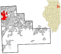
The village includes land in Will County's Plainfield and Wheatland townships, as well as Na-Au-Say and Oswego townships in Kendall County. With the growth in the Chicago suburbs in the 1990s and 2000s, the village has seen a population increase, from 4,500 in 1990 to 28,000 in 2000 to nearly 45,000 in 2016. It is between the cities of Naperville and Joliet.

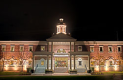
The village has established a community Preservation Commission and historic preservation ordinance. It is the home of the Lake Renwick Preserve, a county forest preserve used for birdwatching and other activities. Located south of Village Hall is Settlers' Park, which includes a lake, war monument, open space, and more. The park presents outdoor concerts to the public in the summer. [3]

History

The area was called "Walkers' Grove" until it was platted as "Plainfield" in 1841. It was originally settled by a large community of Potawatomi people, and the land was later bequeathed to the United States as part of the Treaty of St. Louis (1816) with the Council of the Three Fires. Indian Boundary Road aligns with the western border of the tract of land originally ceded.

The earliest Europeans in the area were French fur traders. The first European-American settler in the area was James Walker, who with his father-in-law, Methodist minister Jessie Walker, traveled here in 1826 where he established a small mission for the Potawatomi people. James Walker, Jesse Walker's son-in-law, traveled with him and became the first European-American to claim land in the area in 1828. [4]

In 1828, James Walker, in the company of several men, erected a sawmill around which the settlement of Walkers' Grove developed.

Plainfield is identified as the oldest community in Will County because the earliest settlement of Walkers' Grove was established on the banks of the DuPage River by 1828. However, the actual village of Plainfield was platted immediately north of Walkers' Grove in 1834 by Chester Ingersoll. The separate community of East Plainfield was platted in June 1836 by James Mathers, who began selling lots in July 1836. He also constructed a gristmill and a mill race west of Water Street, which would later become Plainfield-Naperville Road. Ingersoll's "Planefield" (Plainfield) which comprised lots in Section 16, along with Mather's East Plainfield lots in Section 10 and Levi Arnold's plat of Section 9, all became joined to create the present-day village after the death of Levi Arnolds in 1845.

Walkers' Grove flourished because of the DuPage River and established routes to Fort Dearborn in Chicago, as well as to Ottawa to the west. Reuben Flagg hauled lumber from Walker's mill to Chicago in order to erect the first two frame structures in the city (the P.F.W. Peck House and the George Dole Forwarding House). Chicago also depended upon the settlement for mail and supplies.

The Flanders House in Plainfield Flanders House (5978683004).jpg
The Flanders House in Plainfield

The community's early prosperity was stunted when the Illinois and Michigan Canal opened in 1848, because the village was not located along the canal. Located within the village are numerous Greek Revival, Upright and Wing cottages, [5] [ clarification needed ] a school built in 1847, and a number of early-19th-century homes. Plainfield currently has three buildings listed on the National Register of Historic Places: Plainfield Halfway House, Flanders House, and a 1928 Standard Oil gas station. [6]

Plainfield abolitionists offered food and shelter to runaway slaves following the Underground Railroad. [7]

North Central College was founded in the village in 1861 as Plainfield College.

The Plainfield Public Library District was founded in the village in 1925 as the Nimmons Village of Plainfield Free Public Library.

Plainfield is the birthplace of Eddie Gardner, one of the pilots credited with establishing the transcontinental air mail routes for the United States Postal Service. The earliest architects associated with buildings in Plainfield are J.E. Minott of Aurora; G. Julian Barnes & John H. Barnes of Joliet; and Herbert Cowell of Joliet and Plainfield. [8]

Certain older parts of Plainfield once suffered from extreme traffic congestion. Before Interstate 55 was built just east of the village in the late 1950s, U.S. Route 30 (the Lincoln Highway) and U.S. Route 66 (sometimes referred to as "The Mother Road") merged into one street for three blocks in the center of town on what is now Illinois Route 59. The merge was between Plainfield/Joliet Road on the south to Lockport Street on the north, but continues to be an area of heavy traffic congestion even outside heavy commuting periods.[ original research? ] At one time, the two longest paved highways in the world (Lincoln Highway and U.S. Route 66) crossed within Plainfield. The highways only crossed each other twice and both locations are in Will County. The other location is in neighboring Joliet.

1990 Tornado

On August 28, 1990, an F5 tornado ran its course through Plainfield. The "Plainfield Tornado" killed 29 people, 24 of whom were killed instantly, and 350 were injured. More than 1,100 homes were damaged and destroyed. The tornado made it across more than 16 miles (26 km) in only 8 minutes. It destroyed the only Plainfield high school at the time, now called Plainfield Central High School. [9] A population boom started to take place at the end of the 20th century after the tornado, with a large number of new home subdivisions. Before this, Plainfield was primarily an agricultural town.

Geography

Plainfield is located in northwestern Will County. The village limits extend west into the eastern part of Kendall County. Plainfield is bordered to the north by the city of Naperville, to the northeast by the village of Bolingbrook, to the east by the village of Romeoville, and to the south by the city of Joliet. Farmland in Kendall County is to the west.

Interstate 55 runs along the eastern edge of the village, with access from two exits. I-55 leads northeast 34 miles (55 km) to the center of Chicago and southwest 100 miles (160 km) to Bloomington. U.S. Route 30 passes through the center of Plainfield, leading northwest 13 miles (21 km) to Montgomery and southeast 9 miles (14 km) to Joliet. Illinois Route 126 crosses US-30 in the center of Plainfield, leading northeast 2.5 miles (4.0 km) to I-55 and west 14 miles (23 km) to Yorkville. Illinois Route 59 runs through the center of Plainfield with US-30 but leads north 9 miles (14 km) to the west side of Naperville and south 6 miles (10 km) to Shorewood.

According to the 2010 census, Plainfield has a total area of 24.199 square miles (62.68 km2), of which 23.22 square miles (60.14 km2) (or 95.95%) is land and 0.979 square miles (2.54 km2) (or 4.05%) is water. [10] The DuPage River flows through the village center, running south towards the Des Plaines River in the Illinois River watershed.

Like its namesake, Plainfield's topography is generally flat. Thousands of years ago, land in greater Plainfield used to be part of the bed of proglacial Lake Wauponsee. However, the lake did not hold up long, and eventually drained into the Illinois River valley. [11] The lake left behind a very flat landscape. Much of downtown Plainfield has an elevation of around 600–625 feet (183–191 m) above sea level, with some areas in the western and northwestern portions of the village's outskirts exceeding 700 feet (210 m). This rise in elevation was created by terminal moraines that were formed during the Wisconsin Episode of the last ice age's last glacial period that has been recorded.

Demographics

Historical population
CensusPop.Note
1870 723
1880 686−5.1%
1890 85224.2%
1900 9208.0%
1910 1,01910.8%
1920 1,14712.6%
1930 1,42824.5%
1940 1,4854.0%
1950 1,76418.8%
1960 2,18323.8%
1970 2,92834.1%
1980 3,77729.0%
1990 4,55720.7%
2000 13,038186.1%
2010 39,581203.6%
2020 44,76213.1%
U.S. Decennial Census [12]

As of the census [13] of 2010, there were 39,581 people, 11,920 households, and 10,155 families residing in the village. The population density was 1,621.5 inhabitants per square mile (626.1/km2). There were 12,532 housing units at an average density of 513.4 per square mile (198.2/km2). The racial makeup of the village was 81.72% White, 5.56% African American, 0.22% Native American, 7.62% Asian, 0.04% Pacific Islander, 2.6% from other races, and 2.22% from two or more races. Hispanic or Latino of any race were 10.73% of the population.

There were 11,920 households, out of which 55.4% had children under the age of 18 living with them, 74.2% were married couples living together, 7.9% had a female householder with no husband present, and 14.8% were non-families. 11.5% of all households were made up of individuals, and 2.9% had someone living alone who was 65 years of age or older. The average household size was 3.31 and the average family size was 3.62.

In the village, the population was spread out, with 35.2% under the age of 18, 6% from 18 to 24, 31.8% from 25 to 44, 21.7% from 45 to 64, and 5.3% who were 65 years of age or older. The median age was 33.8 years. For every 100 females, there were 98.4 males. For every 100 females age 18 and over, there were 95 males. [14]

According to a 2014 estimate by the U.S. Census, the median income for a household in the village was $111,536 (~$136,471 in 2022). [15] About 1.0% of families and 1.8% of the population were below the poverty line, including 2.2% of those under age 18 and 2.3% of those age 65 or over.

Architecture of Plainfield, IL

Downtown (Lockport St.)

In the mid 1800's, the business district of Plainfield consisted of wood-framed buildings of all shapes and sizes, yet between 1-2 stories high, and commonly had projecting awnings of wood and metal, along with either false fronted, horizontal wood cornices or large display windows. [16] There were wood plank sidewalks that were elevated 2ft above the dirt roads on a limestone foundation. [16] The last wood-framed building constructed on Lockport St. was in 1869, and the first masonry buildings constructed along Lockport St. were in 1865, and the post 1870 masonry buildings introduced a new commercial look where common design themes began to integrate the buildings together; including: identical floor and roof lines, cast iron storefronts with larger windows, operable canvas awnings, stamped metal cornices, etc.. [16]

Early Churches

The early church buildings of Plainfield were wood-framed and imposed Greek Revival and Gothic Revival edifices along the dirt roads. [16] In the 1850's, four different congregations built churches along Lockport street, including the Methodists, Congregationalists, the Baptists, and the Evangelicals. [16]

In 1836 the Methodists built a wood-framed church (located on present-day Lockport street), and in 1868 they built another church much larger and of limestone (located on present-day Illinois street in downtown Plainfield). [16] [17] The original church built in 1836 was later converted into a business on the first floor and a social hall on the second floor. [16]

In 1850 the Congregational Church (located at present-day Lockport and Illinois streets) was built and cost $2,200. [17] The east wing of the church was added in 1907. [17]

In 1836 the Baptist church erected their first church, sized at 26ft by 36ft, and cost of $2,500. [17] This church was later turned into a blacksmith shop in 1857 following the construction of a new church that costed $4,500-$5,000, and burned down in 1914, then rebuilt on the same site again (located at present-day Division and Lockport streets). [17]

Town Hall Opera House

In 1841 the Town Hall Opera House was built by the Universalist church, and in 1911 it was adopted by the town of Plainfield to be used as the town hall and an opera house and has since been renovated many times. [18] Through all the renovations, the building still has its original Greek trim, and it features a typical Greek entablature supported by all four corners. [18]

Transportation

Major highways

Major highways in Plainfield include:

Pace

The Pace bus system expanded two routes (755 and 855) to Plainfield beginning May 6, 2013. Both routes are "bi-directional, weekday rush hour service" [19] from the Plainfield Village Center to Downtown Chicago. One route terminates in the Illinois Medical District and the other in Chicago's East Loop. [20]

Education

Plainfield Central High School Plainfield High School Central Campus.JPG
Plainfield Central High School

Plainfield Community Consolidated School District 202 serves portions of Plainfield, Joliet, Crest Hill, Bolingbrook, Romeoville, and Plainfield Township in unincorporated parts of Will County.

Peak enrollment in the district took place in 2010–2011 at 29,254 students. The enrollment has been steadily declining since that time, and is currently declining at several hundred students per year. Current enrollment is 25,133 for the 2020–2021 school year. [21]

Plainfield Area High Schools

High School Established School District Location County
Plainfield Central High School 1959 Plainfield Community Consolidated School District 202 24120 Fort Beggs Dr, Plainfield, IL 60544 Will
Plainfield South High School 2001 Plainfield Community Consolidated School District 202 7800 Caton Farm Rd, Plainfield, IL 60586 Kendall
Plainfield North High School 2005 Plainfield Community Consolidated School District 202 12005 S 248th Ave, Plainfield, IL 60585 Will
Plainfield East High School 2008 Plainfield Community Consolidated School District 202 12001 S Naperville Rd, Plainfield, IL 60585 Will

Notable people

See also

Related Research Articles

<span class="mw-page-title-main">Will County, Illinois</span> County in Illinois, United States

Will County is a county in the northeastern part of the state of Illinois. According to the 2020 census, it had a population of 696,355, an increase of 2.8% from 677,560 in 2010, making it Illinois's fourth-most populous county. The county seat is Joliet. Will County is one of the five collar counties of the Chicago–Naperville–Elgin, IL–IN–WI Metropolitan Statistical Area. The portion of Will County around Joliet uses area codes 815 and 779, while 630 and 331 are for far northern Will County and 708 is for central and eastern Will County.

<span class="mw-page-title-main">Woodridge, Illinois</span> Village in Illinois, United States

Woodridge is a village in DuPage County, Illinois, with small portions in Will and Cook counties, and a southwestern suburb of Chicago. Per the 2020 census, the population was 34,158.

<span class="mw-page-title-main">Aurora, Illinois</span> City in Illinois, United States

Aurora is a city in the Chicago metropolitan area. Located primarily in DuPage and Kane Counties, it is the 2nd most populous city in Illinois, after Chicago, and the 144th most populous city in the United States. The population was 197,899 at the 2010 census, and was 180,542 at the 2020 census.

<span class="mw-page-title-main">Bolingbrook, Illinois</span> Village in Illinois, United States

Bolingbrook is a village in Will and DuPage counties in the U.S. state of Illinois. It is a southwest suburb of Chicago on I-55 and Historic Route 66. The village was a new town built on the Gateway Wetlands west of the Des Plaines River in the 1960s. Bolingbrook experienced rapid growth in the 1980s and 1990s, eventually becoming Will county's second largest town after Joliet. Per the 2020 census, the population was 73,922. As of 2010, it is the 17th largest incorporated place in Illinois and the state's second-largest village.

<span class="mw-page-title-main">Darien, Illinois</span> City in Illinois, United States

Darien is a city in DuPage County, Illinois, United States. Per the 2020 census, the population was 22,011. A southwestern suburb of Chicago, Darien was named after the town of Darien, Connecticut. Darien is just north of I-55 and Historic U.S. Route 66. The entire south edge of the town borders Waterfall Glen.

<span class="mw-page-title-main">Naperville, Illinois</span> City in Illinois, United States

Naperville is a city in DuPage and Will counties in the U.S. state of Illinois. It is a southwestern suburb of Chicago located 28 miles (45 km) west of the city on the DuPage River. As of the 2020 census, its population was 149,540, making it the state's fourth-most populous city.

<span class="mw-page-title-main">Montgomery, Illinois</span> Village in Illinois, United States

Montgomery is a village within the Chicago Metropolitan Area of Kane and Kendall counties, Illinois. The village is a suburb/exurb of Chicago located roughly 45 miles (72 km) southwest of the city. The population was 20,262 at the 2020 census.

<span class="mw-page-title-main">Joliet, Illinois</span> City in Illinois, United States

Joliet is a city in Will and Kendall counties in the U.S. state of Illinois, 35 miles (56 km) southwest of Chicago. It is the county seat of Will County. It had a population of 150,362 at the 2020 census, making it the third-most populous city in Illinois.

<span class="mw-page-title-main">Lisbon, Illinois</span> Village in Illinois, United States

Lisbon is a village in Kendall County, Illinois, United States. The population was 271 at the 2020 census.

<span class="mw-page-title-main">Millington, Illinois</span> Village in Illinois, United States

Millington is a village in Kendall and LaSalle counties in the U.S. state of Illinois. The population was 617 at the 2020 census, down from 665 at the 2010 census.

<span class="mw-page-title-main">Yorkville, Illinois</span> City in Illinois, United States

Yorkville is a city within the Chicago Metropolitan Area and is the county seat of Kendall County, Illinois, United States. It is a southwest suburb/exurb of Chicago, Illinois. The population was 22,594 as of the 2020 census.

<span class="mw-page-title-main">Roxana, Illinois</span> Village in Illinois, United States

Roxana is a village in Madison County, Illinois, United States. The population was 1,454 at the 2020 census. The ZIP Code is 62084.

<span class="mw-page-title-main">Lockport, Illinois</span> City in Illinois, United States

Lockport is a city in Will County, Illinois, United States, located 30 miles southwest of Chicago. Per the 2020 census, the population was 26,094. The city was incorporated in 1853. It is situated along the Illinois and Michigan (I&M) Canal, and was the headquarters of the canal when the canal was operating. A section of the canal runs through Lockport, including the remains of the canal's Lock No. 1 from which the town received its name. The canal right-of-way is now the Illinois and Michigan National Heritage Corridor.

<span class="mw-page-title-main">Romeoville, Illinois</span> Village in Illinois, United States

Romeoville is a village in Will County, Illinois, United States. The village is located 26 mi (42 km) southwest of Chicago on the Gateway Wetlands, directly west of the Des Plaines River. Per the 2020 census, the population was 39,863. It is located in the southwest suburban area of Chicago near Interstate 55 and Interstate 355.

<span class="mw-page-title-main">1990 Plainfield tornado</span> Deadly tornado in Illinois

The 1990 Plainfield tornado was a devastating tornado that occurred on the afternoon of Tuesday, August 28, 1990. The violent tornado killed 29 people and injured 353. It is the only F5/EF5 rated tornado ever recorded in August in the United States, and the only F5 tornado to strike the Chicago area. There are no known videos or photographs of the tornado itself; however, in 2011, a video surfaced online showing the supercell that spawned the tornado. The Plainfield tornado was part of a small outbreak that produced several tornadoes in the Northern United States and Ontario and Kansas.

<span class="mw-page-title-main">Homer Glen, Illinois</span> Village in Illinois, United States

Homer Glen is a village, located 32 miles (51 km) southwest of downtown Chicago, in Will County, Illinois, United States, with a small portion in Cook County. Per the 2020 census, the population was 24,543. The village was incorporated on April 17, 2001. The area that is now Homer Glen was formerly known as "Goodings Grove".

<span class="mw-page-title-main">U.S. Route 30 in Illinois</span> Highway in Illinois

U.S. Route 30 (US 30) is an east–west arterial surface road in northern Illinois. It runs from across the Mississippi River from Clinton, Iowa, to Lynwood at the Indiana state line. This is a distance of 153.79 miles (247.50 km).

<span class="mw-page-title-main">Wheatland Township, Will County, Illinois</span> Township in Illinois, United States

Wheatland Township is located in Will County, Illinois. As of the 2010 census, its population was 81,472 and it contained 25,075 housing units.

<span class="mw-page-title-main">Plattville, Illinois</span> Village in Illinois, United States

Plattville is a village in Lisbon Township, Kendall County, Illinois, United States, west of Joliet. As of the 2010 census it had a population of 242. The community was established in 1860 and named after founder Daniel Platt, who first built a home there in 1834 on the Frink and Walker stagecoach route between Chicago and Ottawa.

The Downtown Plainfield Historic District is the historic downtown area of Plainfield, Illinois, United States. The four block district reflects popular architectural styles of the mid-19th through mid-20th century.

References

  1. 1 2 3 U.S. Geological Survey Geographic Names Information System: Plainfield, Illinois
  2. "2020 U.S. Gazetteer Files". United States Census Bureau. Retrieved March 15, 2022.
  3. "Village of Plainfield, IL". www.plainfield-il.org. Retrieved April 25, 2018.
  4. Le Baron, History of Will County, page 478. W.M Le Baron, Jr. and Co. 1878
  5. "Plainfield's historic downtown area along Lockport Street was recently named to the National Register of Historic Places". tribunedigital-chicagotribune. Retrieved May 3, 2018.
  6. "National Register of Historic Places Database and Research Page -- National Register of Historic Places Official Website--Part of the National Park Service". www.nps.gov. Retrieved May 3, 2018.
  7. Curry, J. Seymour,Chicago: Its History and Its Builders, page 414, S. J Clarke Publishing Company, Chicago, 1918
  8. "Lambert: Herbert Cowell, Plainfield's Prolific Architect". May 30, 2012.
  9. "Plainfield 1990 tornado was unique in its formation, destruction, rebuilding". Shaw Local News Network. Retrieved May 3, 2018.
  10. "G001 - Geographic Identifiers - 2010 Census Summary File 1". United States Census Bureau. Archived from the original on February 13, 2020. Retrieved December 25, 2015.
  11. "Online Resources | Illinois State Museum".
  12. "Census of Population and Housing". Census.gov. Retrieved June 4, 2015.
  13. "Profile of General Population and Housing Characteristics: 2010". Census.gov. Archived from the original on February 13, 2020. Retrieved October 7, 2017.
  14. "Age Groups and Sex: 2010". Census.gov. Archived from the original on February 13, 2020. Retrieved October 7, 2017.
  15. https://www.census.gov/quickfacts/table/PST045215/1760287,00 [ dead link ]
  16. 1 2 3 4 5 6 7 Lambert, Michael A.; Flynn, Thomas H. (2000). Village of Plainfield Illinois Design Manual for the Lockport Street Business Corridor. Plainfield, Illinois: ARRIS Architects and Planners.
  17. 1 2 3 4 5 Smtih, TIm and Michelle (2012). Images of America; Plainfield (1st ed.). Charleston, South Carolina: Arcadia Publishing. ISBN   978-0-7385-9438-5.
  18. 1 2 "History of the Town Hall Opera House Building". Plainfield Arts. Retrieved December 1, 2023.
  19. "Pace Bus - Route 755 - Plainfield - IMD Express". www.pacebus.com. Archived from the original on December 9, 2009.
  20. "Pace Expands Plainfield-Chicago Service Thanks to Bus-on-Shoulder Success". May 2013.
  21. "Enrollment". School District 202.
  22. "Chicago's Shea Coulee finally gets her chance to 'Race'". Chicago Sun-Times. Retrieved June 7, 2018.
  23. "Kristopher Prather PBA Profile". pba.com. November 13, 2014. Retrieved June 10, 2019.