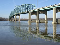
Marshall County | |
---|---|
Coordinates: 41°02′N89°20′W / 41.03°N 89.34°W | |
Country | United States |
State | Illinois |
Founded | January 19, 1839 |
Named for | John Marshall |
Seat | Lacon |
Largest city | Henry |
Area | |
• Total | 399 sq mi (1,030 km2) |
• Land | 387 sq mi (1,000 km2) |
• Water | 12 sq mi (30 km2) 2.9% |
Population (2020) | |
• Total | 11,742 |
• Density | 29/sq mi (11/km2) |
Time zone | UTC−6 (Central) |
• Summer (DST) | UTC−5 (CDT) |
Congressional district | 16th |
Website | www |
Marshall County is a county located in the U.S. state of Illinois. According to the 2020 census, it had a population of 11,742. [1] Its county seat is Lacon. [2]
Marshall County is part of the Peoria, IL Metropolitan Statistical Area.
Marshall County was formed in 1839 out of Putnam County. It was named in honor of John Marshall, Chief Justice of the United States Supreme Court, who died in 1835. [3]
According to the U.S. Census Bureau, the county has a total area of 399 square miles (1,030 km2), of which 387 square miles (1,000 km2) is land and 12 square miles (31 km2) (2.9%) is water. [4] The county is distinctly bisected by the Illinois River, splitting the county into two uneven sections.[ citation needed ]
Lacon, Illinois | ||||||||||||||||||||||||||||||||||||||||||||||||||||||||||||
---|---|---|---|---|---|---|---|---|---|---|---|---|---|---|---|---|---|---|---|---|---|---|---|---|---|---|---|---|---|---|---|---|---|---|---|---|---|---|---|---|---|---|---|---|---|---|---|---|---|---|---|---|---|---|---|---|---|---|---|---|
Climate chart (explanation) | ||||||||||||||||||||||||||||||||||||||||||||||||||||||||||||
| ||||||||||||||||||||||||||||||||||||||||||||||||||||||||||||
|
In recent years, average temperatures in the county seat of Lacon have ranged from a low of 15 °F (−9 °C) in January to a high of 87 °F (31 °C) in July, although a record low of −27 °F (−33 °C) was recorded in January 1999 and a record high of 103 °F (39 °C) was recorded in July 2005. Average monthly precipitation ranged from 1.55 inches (39 mm) in January to 4.20 inches (107 mm) in May. [5]
Census | Pop. | Note | %± |
---|---|---|---|
1840 | 1,849 | — | |
1850 | 5,180 | 180.2% | |
1860 | 13,437 | 159.4% | |
1870 | 16,956 | 26.2% | |
1880 | 15,055 | −11.2% | |
1890 | 13,653 | −9.3% | |
1900 | 16,370 | 19.9% | |
1910 | 15,679 | −4.2% | |
1920 | 14,760 | −5.9% | |
1930 | 13,023 | −11.8% | |
1940 | 13,179 | 1.2% | |
1950 | 13,025 | −1.2% | |
1960 | 13,334 | 2.4% | |
1970 | 13,302 | −0.2% | |
1980 | 14,479 | 8.8% | |
1990 | 12,846 | −11.3% | |
2000 | 13,180 | 2.6% | |
2010 | 12,640 | −4.1% | |
2020 | 11,742 | −7.1% | |
2023 (est.) | 11,683 | [6] | −0.5% |
U.S. Decennial Census [7] 1790-1960 [8] 1900-1990 [9] 1990-2000 [10] 2010 [11] |
As of the 2010 United States census, there were 12,640 people, 5,161 households, and 3,549 families living in the county. [12] The population density was 32.7 inhabitants per square mile (12.6/km2). There were 5,914 housing units at an average density of 15.3 per square mile (5.9/km2). [4] The racial makeup of the county was 97.1% white, 0.4% Asian, 0.3% black or African American, 0.2% American Indian, 1.1% from other races, and 0.9% from two or more races. Those of Hispanic or Latino origin made up 2.5% of the population. [12] In terms of ancestry, 43.0% were German, 16.7% were Irish, 14.4% were English, 7.2% were Italian, 6.2% were American, and 6.1% were Polish. [13]
Of the 5,161 households, 27.4% had children under the age of 18 living with them, 56.7% were married couples living together, 7.7% had a female householder with no husband present, 31.2% were non-families, and 26.8% of all households were made up of individuals. The average household size was 2.40 and the average family size was 2.88. The median age was 44.8 years. [12]
The median income for a household in the county was $49,116 and the median income for a family was $64,781. Males had a median income of $46,793 versus $28,549 for females. The per capita income for the county was $24,991. About 6.8% of families and 9.5% of the population were below the poverty line, including 11.4% of those under age 18 and 7.0% of those age 65 or over. [14]
In its early days Marshall County was a swing county, voting for winning Whig candidate William Henry Harrison in 1840 but otherwise supporting the Democratic Party until 1852. Its reputation as a swing county was to be sustained with the growth of the Republican Party: it voted for the winning candidate in every election from 1852 to 1912 except 1884 and 1888.[ citation needed ]
Since World War I, Marshall has generally been a strongly Republican county. Only two Democrats – Franklin D. Roosevelt in 1932 and 1936 plus Lyndon Johnson in 1964 – have gained an absolute majority in Marshall County over the past twenty-six elections, although Bill Clinton won pluralities in both his elections.[ citation needed ]
Year | Republican | Democratic | Third party(ies) | |||
---|---|---|---|---|---|---|
No. | % | No. | % | No. | % | |
2024 | 4,119 | 66.93% | 1,913 | 31.09% | 122 | 1.98% |
2020 | 4,197 | 66.15% | 2,005 | 31.60% | 143 | 2.25% |
2016 | 3,785 | 63.25% | 1,789 | 29.90% | 410 | 6.85% |
2012 | 3,290 | 56.06% | 2,455 | 41.83% | 124 | 2.11% |
2008 | 3,145 | 49.54% | 3,081 | 48.53% | 122 | 1.92% |
2004 | 3,734 | 56.71% | 2,806 | 42.62% | 44 | 0.67% |
2000 | 3,145 | 53.24% | 2,570 | 43.51% | 192 | 3.25% |
1996 | 2,453 | 42.93% | 2,640 | 46.20% | 621 | 10.87% |
1992 | 2,491 | 38.35% | 2,819 | 43.40% | 1,186 | 18.26% |
1988 | 3,588 | 56.35% | 2,742 | 43.07% | 37 | 0.58% |
1984 | 4,060 | 62.53% | 2,386 | 36.75% | 47 | 0.72% |
1980 | 4,349 | 64.80% | 1,903 | 28.36% | 459 | 6.84% |
1976 | 4,017 | 60.30% | 2,570 | 38.58% | 75 | 1.13% |
1972 | 4,452 | 67.43% | 2,141 | 32.43% | 9 | 0.14% |
1968 | 3,897 | 58.36% | 2,455 | 36.77% | 325 | 4.87% |
1964 | 3,209 | 47.40% | 3,561 | 52.60% | 0 | 0.00% |
1960 | 4,150 | 58.14% | 2,981 | 41.76% | 7 | 0.10% |
1956 | 4,764 | 67.92% | 2,245 | 32.01% | 5 | 0.07% |
1952 | 4,850 | 67.35% | 2,343 | 32.54% | 8 | 0.11% |
1948 | 3,785 | 59.91% | 2,514 | 39.79% | 19 | 0.30% |
1944 | 4,195 | 61.68% | 2,596 | 38.17% | 10 | 0.15% |
1940 | 4,527 | 57.23% | 3,343 | 42.26% | 40 | 0.51% |
1936 | 3,544 | 45.67% | 4,149 | 53.47% | 67 | 0.86% |
1932 | 3,166 | 43.10% | 4,133 | 56.27% | 46 | 0.63% |
1928 | 4,029 | 58.69% | 2,828 | 41.19% | 8 | 0.12% |
1924 | 3,776 | 58.41% | 1,836 | 28.40% | 853 | 13.19% |
1920 | 3,734 | 67.61% | 1,568 | 28.39% | 221 | 4.00% |
1916 | 3,579 | 55.83% | 2,593 | 40.45% | 238 | 3.71% |
1912 | 790 | 20.97% | 1,685 | 44.72% | 1,293 | 34.32% |
1908 | 1,893 | 50.13% | 1,714 | 45.39% | 169 | 4.48% |
1904 | 2,190 | 55.97% | 1,545 | 39.48% | 178 | 4.55% |
1900 | 2,210 | 52.78% | 1,908 | 45.57% | 69 | 1.65% |
1896 | 2,216 | 53.26% | 1,888 | 45.37% | 57 | 1.37% |
1892 | 1,590 | 44.99% | 1,834 | 51.90% | 110 | 3.11% |
Putnam County is the least extensive county in the U.S. state of Illinois. According to the 2020 census, it had a population of 5,637. The county seat is Hennepin. The county was formed in 1825 out of Fulton County and named after Israel Putnam, who was a general in the American Revolution. Putnam County is part of the Ottawa, IL Micropolitan Statistical Area.
Montgomery County is a county located in the U.S. state of Illinois. According to the 2020 census, it had a population of 28,288. Its county seat is Hillsboro.
Morgan County is a county in the north-central part of the U.S. state of Alabama. As of the 2020 census, its population was 123,421. The county seat is Decatur. On June 14, 1821, it was renamed in honor of American Revolutionary War General Daniel Morgan of Virginia. It is a prohibition or dry county, although alcohol sales are allowed in the cities of Decatur, Hartselle, and Priceville. Morgan County is included in the Decatur, AL Metropolitan Statistical Area, which is also included in the Huntsville-Decatur-Albertville, AL Combined Statistical Area. It is a part of the North, Northwest, and North-Central regions of Alabama.
Washington County is a county located in the U.S. state of Illinois. As of the 2020 census, it had a population of 13,761. Its county seat is Nashville. It is located in the southern portion of Illinois known locally as "Little Egypt".
Stark County is a county in Illinois. According to the 2020 census, it had a population of 5,400. Its county seat is Toulon.
Shelby County is a county located in the U.S. state of Illinois. According to the 2020 census, it had a population of 20,990. Its county seat is Shelbyville.
Scott County is a county located in the U.S. state of Illinois. According to the 2020 census, it had a population of 4,949, making it the fourth-least populous county in Illinois. Its county seat is Winchester.
Pulaski County is a county located in the U.S. state of Illinois. According to the 2020 census, it had a population of 5,193. Its county seat is Mound City. Its largest city is Mounds. It is located along the Ohio River in the southwestern portion of the state, known locally as "Little Egypt".
Christian County is a county located in the U.S. state of Illinois. As of the 2020 census, the population was 34,032. Its county seat is Taylorville.
Bureau County is a county located in the U.S. state of Illinois. As of the 2020 United States Census, the population was 33,244. Its county seat is Princeton. Bureau County is part of the Ottawa, IL Micropolitan Statistical Area, and the Hennepin Canal Parkway State Park is located partly in this county.
Loves Park is a city in Boone and Winnebago counties in the U.S. state of Illinois. Most of the city is in Winnebago County, with a tiny sliver in the east located in Boone County. The population was 23,397 at the 2020 census.
Hopewell is a village in Marshall County, Illinois, United States. The population was 421 at the 2020 census. It is part of the Peoria Metropolitan Statistical Area. The village was incorporated in 1983.
La Rose is a village in Bell Plain Township, Marshall County, Illinois, United States. The population was 98 at the 2020 census, down from 144 in 2010. It is part of the Peoria Metropolitan Statistical Area.
Lacon is a city in, and the county seat of, Marshall County, Illinois, United States. It is part of the Peoria Metropolitan Statistical Area. The population was 1,878 at the 2020 census, down from 1,937 in 2010.
Sparland is a village in Marshall County, Illinois, United States. The population was 366 at the 2020 census, down from 406 in 2010. It is part of the Peoria Metropolitan Statistical Area.
Toluca is a city in Marshall County, Illinois, United States. The population was 1,340 at the 2020 census. It is part of the Peoria, Illinois, Metropolitan Statistical Area.
Varna is a village in Marshall County, Illinois, United States. The population was 375 at the 2020 census. It is part of the Peoria Metropolitan Statistical Area.
Washburn is a village mostly in Woodford County, with a small northerly portion in Marshall County, Illinois, United States. The population was 1,032 at the 2020 census. It is part of the Peoria Metropolitan Statistical Area.
Hopewell is a borough in Bedford County, Pennsylvania, United States. The population was 189 at the 2020 census.
Hopewell Township is a township in Washington County, Pennsylvania, United States. The population was 853 at the 2020 census.