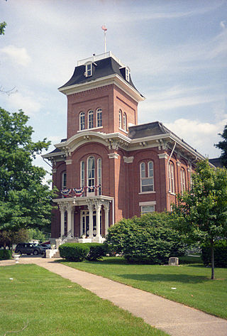
Walworth County is a county located in the U.S. state of Wisconsin. As of the 2020 census, the population was 106,478. Its county seat is Elkhorn. The county was created in 1836 from Wisconsin Territory and organized in 1839. It is named for Reuben H. Walworth. Walworth County comprises the Whitewater-Elkhorn, WI Micropolitan Statistical Area and is included in the Milwaukee-Racine-Waukesha, WI Combined Statistical Area. Lake Geneva, the University of Wisconsin-Whitewater, and Alpine Valley Resort, and Music Theatre are located in Walworth County.

Randolph County is a county located in the U.S. state of Illinois. According to the 2020 census, it had a population of 30,163. Its county seat is Chester.

Ogle County is a county in the northern part of the U.S. state of Illinois. According to the 2020 United States Census, it had a population of 51,788. Its county seat is Oregon, and its largest city is Rochelle. Ogle County comprises Rochelle, IL Micropolitan Statistical Area, which is also included in the Rockford-Freeport-Rochelle, IL Combined Statistical Area.

McDonough County is a county in the U.S. state of Illinois. According to the 2020 census, it had a population of 27,238. Its county seat is Macomb, which is also the home of Western Illinois University.

Marshall County is a county located in the U.S. state of Illinois. According to the 2020 census, it had a population of 11,742. Its county seat is Lacon.

Livingston County is a county located in the U.S. state of Illinois. According to the 2020 census, it has a population of 35,815. Its county seat is Pontiac. Livingston County comprises the Pontiac, IL Micropolitan Statistical Area, which is combined with the Bloomington–Normal metropolitan statistical area as the Bloomington-Pontiac, IL Combined Statistical Area in upper portion of Central Illinois.

LaSalle County is located within the Fox Valley and Illinois River Valley regions of the U.S. state of Illinois. As of the 2020 Census, it had a population of 109,658. Its county seat and largest city is Ottawa. LaSalle County is part of the Ottawa, IL Micropolitan Statistical Area of Northern Illinois.

Kane County is a county in the U.S. state of Illinois. According to the 2020 census, it has a population of 516,522, making it the fifth-most populous county in Illinois. Its county seat is Geneva, and its largest city is Aurora. Kane County is one of the collar counties of the metropolitan statistical area designated "Chicago–Naperville–Elgin, IL–IN–WI" by the US Census.

Iroquois County is a county located in the northeast part of the U.S. state of Illinois. According to the 2020 United States Census, it has a population of 27,077. It is the only county in the United States to be named Iroquois, after the American Indian people. The county seat is Watseka. The county is located along the border with Indiana.

Clark County is a county located in the southeastern part of U.S. state of Illinois, along the Indiana state line. As of the 2020 census, the population was 15,455. Its county seat is Marshall. The county was named for George Rogers Clark, an officer who served in the American Revolution.

Lincolnshire is a village in Vernon Township, Lake County, in the U.S. state of Illinois. The village is a northern suburb of Chicago. Per the 2020 census, the population was 7,940. Lincolnshire was incorporated on August 5, 1957, from the unincorporated Half Day area when land was purchased to build a residential subdivision. The community underwent an aggressive era of expansion from 1983 to the 1990s. The Des Plaines River bisects the village, passing from north to south; Illinois Route 22 also divides the village into two parts, crossing the village from east to west.

Illinois Route 31 (IL 31) is a 58.41-mile-long (94.00 km) north–south state highway in northeastern Illinois, United States. It travels from U.S. Route 34 (US 34) in Oswego north to US 12, near the Wisconsin state line, just south of Richmond.

Indiana's 2nd congressional district is an electoral district for the U.S. Congress in Northern Indiana. It includes South Bend, Elkhart, and Warsaw.

The Peoria Metropolitan Statistical Area, as defined by the United States Census Bureau, is an area consisting of six counties in Central Illinois, anchored by the city of Peoria. As of the 2020 census, the area had a population of 402,391. The City of Peoria, according to the 2020 US Census Bureau, has 113,150 people.
Big Foot Prairie is an unincorporated community and census-designated place in McHenry County, Illinois, United States. It was named a CDP for the 2020 census, at which time it had a population of 65. It is located in Chemung Township. Big Foot Prairie is located on U.S. Route 14, 5 miles (8.0 km) north of Harvard. The community extends north into Walworth County, Wisconsin, where there is a CDP of the same name in the town of Walworth.
Marigold is an unincorporated community in Randolph County, Illinois, United States. The community is located on County Route 12 4.9 miles (7.9 km) east of Prairie du Rocher.
Prairie Hall is an unincorporated community in Mount Zion Township, Macon County, Illinois, United States. The community is on Prairie Hall Road 4.9 miles (7.9 km) east-southeast of Mount Zion.


