Freeport, Illinois | |
---|---|
Nickname(s): Pretzel City, USA | |
Coordinates: 42°17′31″N89°37′49″W / 42.29194°N 89.63028°W | |
Country | United States |
State | Illinois |
County | Stephenson |
Township | Freeport |
Founded | 1827 |
Incorporated | 1838 |
Government | |
• Mayor | Jodi Miller [1] |
Area | |
• Total | 11.89 sq mi (30.79 km2) |
• Land | 11.88 sq mi (30.77 km2) |
• Water | 0.01 sq mi (0.02 km2) |
Elevation | 778 ft (237 m) |
Population (2020) | |
• Total | 23,973 |
• Density | 2,017.76/sq mi (779.04/km2) |
ZIP Code(s) | 61032, 61033 |
Area code | 815/779 |
FIPS code | 17-27884 |
Wikimedia Commons | Freeport, Illinois |
Website | www |
[3] |
Freeport is the county seat and largest city of Stephenson County, Illinois, United States. [4] The population was 23,973 at the 2020 census, [5] and the mayor of Freeport is Jodi Miller, elected in 2017. Freeport is known for hosting the second Lincoln-Douglas debate of 1858, and as "Pretzel City, USA", due to a popular local German bakery that became well known for its prolific pretzel production after it opened in 1869. Freeport High School's mascot is the Pretzel to honor its heritage.
The community was originally called Winneshiek. [6] When it was incorporated, the new municipality took its name from the generosity of Tutty Baker, who was credited with running a "free port" on the Pecatonica River. The name "Winneshiek" was later adopted, and is preserved to this day, by the Freeport Community Theatre Group.
In 1837, Stephenson County was formed and Freeport became its seat of government in 1838. Linked by a stagecoach with Chicago, the community grew rapidly. In 1840, a frame courthouse was erected and the first school was founded. Within two years, Freeport had two newspapers and in 1853, the two were joined by a third which published in German. By then, the community had a population of 2,000.
On August 27, 1858, the second debate between Abraham Lincoln and Stephen A. Douglas took place in Freeport and gave the nation direction in the following years. Although Stephen Douglas won the election and retained his U.S. Senate seat, his reply to a question on slavery alienated the South, which called it the "Freeport Heresy", and split the Democratic Party. [7] This enabled Abraham Lincoln to win the Presidency in 1860.
A monument to the debate was dedicated in 1903 by President Theodore Roosevelt and stands at this site. A life size statue recreating the event was dedicated in 1992. Another renowned statue, Lincoln the Debator by Leonard Crunelle, is a focal point in the city's Taylor Park. In many years there is also a reenactment of the debate, which has been shown on C-SPAN.
Freeport is known as the "Pretzel City", and its public high school's team is named the Pretzels. The nickname is a reminder of Freeport's ethnic heritage: in the late 1850s, many Germans, both from Pennsylvania and from their European homeland, resettled in Stephenson County bringing with them their love of pretzel snacks. [8] In 1869, a German immigrant named John Billerbeck [9] established the Billerbeck Bakery, which distributed so many pretzels to residents that the local newspaper later dubbed Freeport the "Pretzel City". The city later capitalized on this nickname in 2003 by starting Freeport's first Pretzel Festival. [10] [11]
Before February 1893, a large square of land was purchased from the former Keller-Wittbecker farm in East Freeport. [12] Some of this land had been subdivided and platted as the "Arcade Addition", as Arcade Manufacturing used some of that square of land in 1893 to rebuild its factory after a fire in its original location had destroyed everything. [12] The Arcade Manufacturing Company had been in operation since 1885 when the previous Novelty Iron Works had gone out of business at the corner of Chicago and Jackson streets. That earlier company began as early as 1868. After the 1892 fire, the Arcade Manufacturing Company built an entirely new factory in the Arcade Addition of East Freeport, where they produced coffee mills and other metal products.
Freeport is home to the oldest Carnegie Library in Illinois [13] and one of the first Carnegie Libraries designed by the Chicago architectural firm of Patton and Miller. It was renovated into Freeport's city hall [14] and city offices were moved to Carnegie City Hall in February 2017. [15]
The City of Freeport transitioned to the city manager form of government in May 2017.[ citation needed ]
Freeport is located approximately 20 miles (32 km) south of the Wisconsin state line, and at the center of a large agricultural area, located about 114 miles (183 km) northwest of Chicago, and 25 miles (40 km) west of Rockford.
According to the U.S. Census Bureau, the city has a total area of 11.89 square miles (30.8 km2), of which 11.88 square miles (30.8 km2) is land and 0.01 square miles (0.026 km2) is water. [16]
U.S. Route 20 is a four-lane divided highway that skirts the community's northern edge. At Rockford, it links with Interstates 90 and 39, giving Freeport residents access to the entire Interstate system. From Freeport, U.S. 20 continues west to Galena, and the metropolitan area of Dubuque, Iowa.
The area code for Freeport is 815 with an overlay area code of 779 as of March 17, 2007 [update] .
The Pecatonica River has flooded Freeport seven times since May 2017. The necessary flood cleanup has cost the city more than $1.5 million. [17]
The frequency of severe weather events appears to be increasing. According to the State Climatologist, "the number of days Freeport has experienced heavy rainfall has steadily increased every decade since 1949." [17] The city is seeking funding to buy out homes in flood-prone neighborhoods. One study estimates that for "every $1 communities like Freeport spend to relocate their residents they will save $6 in future clean ups." [17]
Climate data for Freeport, Illinois (1991–2020 normals, extremes 1973–present) | |||||||||||||
---|---|---|---|---|---|---|---|---|---|---|---|---|---|
Month | Jan | Feb | Mar | Apr | May | Jun | Jul | Aug | Sep | Oct | Nov | Dec | Year |
Record high °F (°C) | 61 (16) | 69 (21) | 85 (29) | 92 (33) | 96 (36) | 100 (38) | 103 (39) | 101 (38) | 96 (36) | 90 (32) | 77 (25) | 67 (19) | 103 (39) |
Mean daily maximum °F (°C) | 27.9 (−2.3) | 32.6 (0.3) | 44.9 (7.2) | 58.2 (14.6) | 69.9 (21.1) | 79.3 (26.3) | 82.4 (28.0) | 80.7 (27.1) | 74.3 (23.5) | 61.5 (16.4) | 46.0 (7.8) | 33.3 (0.7) | 57.6 (14.2) |
Daily mean °F (°C) | 19.6 (−6.9) | 23.7 (−4.6) | 35.4 (1.9) | 47.3 (8.5) | 59.1 (15.1) | 69.0 (20.6) | 72.4 (22.4) | 70.3 (21.3) | 62.6 (17.0) | 50.4 (10.2) | 37.1 (2.8) | 25.6 (−3.6) | 47.7 (8.7) |
Mean daily minimum °F (°C) | 11.3 (−11.5) | 14.8 (−9.6) | 25.8 (−3.4) | 36.4 (2.4) | 48.4 (9.1) | 58.6 (14.8) | 62.3 (16.8) | 59.9 (15.5) | 51.0 (10.6) | 39.3 (4.1) | 28.2 (−2.1) | 17.9 (−7.8) | 37.8 (3.2) |
Record low °F (°C) | −31 (−35) | −31 (−35) | −19 (−28) | 9 (−13) | 25 (−4) | 38 (3) | 46 (8) | 40 (4) | 28 (−2) | 15 (−9) | −5 (−21) | −23 (−31) | −31 (−35) |
Average precipitation inches (mm) | 1.58 (40) | 1.65 (42) | 2.15 (55) | 3.66 (93) | 4.36 (111) | 5.26 (134) | 4.21 (107) | 4.21 (107) | 4.11 (104) | 2.98 (76) | 2.36 (60) | 1.83 (46) | 38.36 (974) |
Average snowfall inches (cm) | 9.7 (25) | 8.5 (22) | 3.8 (9.7) | 0.8 (2.0) | 0.0 (0.0) | 0.0 (0.0) | 0.0 (0.0) | 0.0 (0.0) | 0.0 (0.0) | 0.2 (0.51) | 2.6 (6.6) | 8.9 (23) | 34.5 (88) |
Average precipitation days (≥ 0.01 in) | 8.7 | 8.0 | 9.4 | 10.7 | 13.1 | 11.7 | 9.8 | 9.7 | 9.0 | 9.4 | 8.1 | 8.7 | 116.3 |
Average snowy days (≥ 0.1 in) | 6.0 | 5.0 | 2.9 | 0.6 | 0.0 | 0.0 | 0.0 | 0.0 | 0.0 | 0.1 | 1.2 | 5.0 | 20.8 |
Source: NOAA [18] [19] |
Census | Pop. | Note | %± |
---|---|---|---|
1840 | 491 | — | |
1850 | 1,436 | 192.5% | |
1860 | 5,376 | 274.4% | |
1870 | 7,889 | 46.7% | |
1880 | 8,516 | 7.9% | |
1890 | 10,189 | 19.6% | |
1900 | 13,258 | 30.1% | |
1910 | 17,587 | 32.7% | |
1920 | 19,669 | 11.8% | |
1930 | 22,045 | 12.1% | |
1940 | 22,368 | 1.5% | |
1950 | 22,467 | 0.4% | |
1960 | 26,628 | 18.5% | |
1970 | 27,736 | 4.2% | |
1980 | 26,266 | −5.3% | |
1990 | 25,840 | −1.6% | |
2000 | 26,443 | 2.3% | |
2010 | 25,638 | −3.0% | |
2020 | 23,973 | −6.5% | |
Census Quickfacts [20] |
As of the census of 2020, [5] the population was 23,973. The population density was 2,017.8 inhabitants per square mile (779.1/km2). There were 11,888 housing units at an average density of 1,000.6 per square mile (386.3/km2). The racial makeup of the city was 68.9% White, 17.9% Black or African American, 1.0% Asian, 0.4% Native American, 2.9% from other races, and 8.8% from two or more races. Ethnically, the population was 7.1% Hispanic or Latino of any race.
As of the census [21] of 2000, there were 26,443 people, 11,222 households, and 6,845 families residing in the city. The population density was 2,316.9 inhabitants per square mile (894.6/km2). There were 12,471 housing units at an average density of 1,092.7 per square mile (421.9/km2). The racial makeup of the city was 81.77% White, 13.81% African American, 0.19% Native American, 0.97% Asian, 0.04% Pacific Islander, 1.00% from other races, and 2.22% from two or more races. Hispanic or Latino of any race were 2.12% of the population.
There were 11,222 households, out of which 28.4% had children under the age of 18 living with them, 45.1% were married couples living together, 12.6% had a female householder with no husband present, and 39.0% were non-families. 33.7% of all households were made up of individuals, and 15.1% had someone living alone who was 65 years of age or older. The average household size was 2.29 and the average family size was 2.93.
In the city, the population was spread out, with 24.5% under the age of 18, 8.5% from 18 to 24, 27.8% from 25 to 44, 21.2% from 45 to 64, and 18.1% who were 65 years of age or older. The median age was 38 years. For every 100 females, there were 87.1 males. For every 100 females age 18 and over, there were 83.8 males.
The median income for a household in the city was $35,399, and the median income for a family was $43,787. Males had a median income of $35,870 versus $25,095 for females. The per capita income for the city was $18,680. About 9.9% of families and 13.1% of the population were below the poverty line, including 18.6% of those under age 18 and 9.5% of those age 65 or over.
Tourist sites in the area include the Don Opel Arboretum, a botanical garden with over 3,000 different species of ground coverings, trees and shrubs. The Stephenson County Historical Society Museum includes Oscar Taylor House, a one-room schoolhouse, the Industrial/Arcade Toy Museum, an Irish homestead log cabin, and an arboretum. [22] The Freeport Art Museum is located on N. Harlem Avenue. [23]
Local Freeport media includes WFRL (1570 AM), WFPS Radio (92.1 FM) and The Journal Standard daily newspaper.
Freeport and surrounding Stephenson County is serviced by Pretzel City Area Transit (PCAT) This is a private company in a partnership with the Senior Resource Center, the city of Freeport provides small bus and/or van transportation throughout all of Stephenson County. With a fleet of 14 small buses / vans, PCAT provides over 83,000 rides per year. [39]
US-20 Runs along the north side of freeport.
Albertus Airport is a civil public-use airport located 3-mile (4.8 km) southeast of the city. The airport is owned by the city.
Freeport has a rail line running east and west on the north side of city. Amtrak "Black Hawk" serviced the city until 2014.[ citation needed ] Freeport station is a historic station.
Lincoln County is located in the eastern part of the U.S. state of Missouri. As of the 2020 census, the population was 59,574. Its county seat is Troy. The county was founded December 14, 1818, and named for Major General Benjamin Lincoln of the American Revolutionary War.
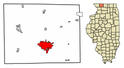
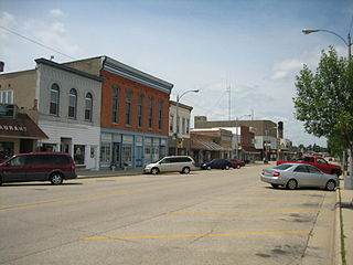
Stephenson County is a county located in the U.S. state of Illinois. According to the 2020 United States Census, it had a population of 44,630. Its county seat is Freeport. Stephenson County is included in the Freeport, IL Micropolitan Statistical Area, which is also included in the Rockford-Freeport-Rochelle, IL Combined Statistical Area.
Madison County is a county in the U.S. state of Illinois. It is a part of the Metro East in southern Illinois. According to the 2020 census, it had a population of 264,776, making it the eighth-most populous county in Illinois and the most populous in the southern portion of the state. The county seat is Edwardsville, and the largest city is Granite City.
Hancock County is a county in the U.S. state of Illinois. According to the 2020 census, it has a population of 17,620. Its county seat is Carthage, and its largest city is Hamilton. The county is composed of rural towns with many farmers.
Brookfield is a village in Cook County, Illinois, United States, located 13 miles (21 km) west of downtown Chicago. Per the 2020 census, the population was 19,476. The city is home to the Brookfield Zoo.
Calumet City is a city in Cook County, Illinois, United States. The population was 36,033 at the 2020 census. It is part of the Chicago metropolitan area.
Dallas City is a city in Hancock and Henderson counties in the U.S. state of Illinois. The population in 2020 stands at an estimate of 805, a decline from the 2010 census of 945, which was a decline from 1,055 in 2000.
Gilberts is a village in Kane County, Illinois, United States. The population was 8,366 at the 2020 census.
Rochelle is a city in Ogle County, Illinois. The population was 9,446 at the 2020 census. Rochelle is approximately 80 miles (130 km) west of Chicago and 25 miles (40 km) south of Rockford.
Lena is a village in Stephenson County, Illinois. The population was 2,772 at the 2020 census.
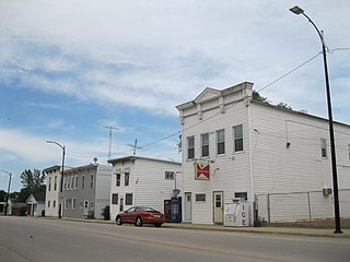
Orangeville is a village in Stephenson County, Illinois, United States. The town's sign lists the population at 800 as of January 2021. The population in 2020 was 738. The population according to the 2010 census was 793, up from 751 in 2000. Using the 2020 population of 738 Orangeville is the 741st largest city in Illinois and the 11,650th largest city in the United States. Orangeville is currently declining at a rate of -0.94% annually and its population has decreased by -6.94% since the 2010 census. The area's earliest white settlers arrived in the year 1833, and the village was platted in 1851 by John Bower, who is considered the village founder. In 1867 Orangeville was incorporated as a village. The town's central business district contains several 19th century commercial buildings, many of which were built during the railroad boom of 1888–1914. By the time the Great Depression was ongoing, business in Orangeville had started to decline, with the last bank closing in 1932. In 1956 another bank started operating in the village and is still in town today. Some recent infrastructure jumps have restored some of the village's old decor.
Pearl City is an incorporated village in Stephenson County, Illinois, with a population of 838 at the 2010 census, up from 780 in 2000.
Pecatonica is a village in Winnebago County, Illinois, United States. It is part of the Rockford, Illinois Metropolitan Statistical Area. The population was 2,195 at the 2010 census, up from 1,997 in 2000.
Surfside Beach, also known locally as Surfside, is a city in Brazoria County, Texas, United States, that is situated on Follet's Island by the Gulf of Mexico near the city of Freeport. The population was 640 at the 2020 census. The city has claimed the "Cradle of Texas Liberty" title due to the fact that the Treaty of Velasco which ended hostilities between Texas and Mexico was signed at Fort Velasco, which was located near the city's current City Hall.
Erin Township is located in Stephenson County, Illinois. As of the 2010 census, its population was 410 and it contained 177 housing units. The unincorporated community of Eleroy is located in the township.
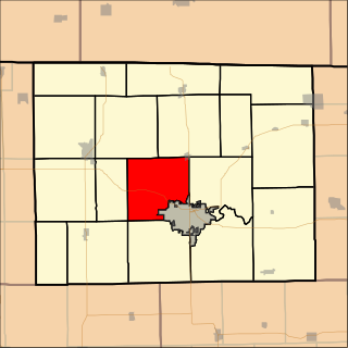
Freeport Township is located in Stephenson County, Illinois. As of the 2010 census, its population was 25,638 and it contained 12,396 housing units. Freeport Township is coterminous with City of Freeport. It is one of seventeen coterminous townships in Illinois.
Harlem Township is located in Stephenson County, Illinois. As of the 2010 census, its population was 2,275 and it contained 981 housing units.
Ridott Township is located in Stephenson County, Illinois, USA. At the 2010 census, its population was 1,451 and it contained 612 housing units. The villages of Ridott and German Valley are located in this township.
Silver Creek Township is a township in Stephenson County, Illinois. As of the 2010 census, its population was 696 and it contained 332 housing units.
St. Charles is a city in DuPage and Kane counties in the U.S. state of Illinois. It lies roughly 40 miles (64 km) west of Chicago on Illinois Route 64. Per the 2020 census, the population was 33,081. The official city slogan is "Pride of the Fox", after the Fox River that runs through the center of town. St. Charles is part of a tri-city area along with Geneva and Batavia, all western suburbs of similar size and socioeconomic condition.