History
Salem was founded in 1823 as the county seat of the newly formed Marion County. It is situated halfway between the Indiana and Missouri borders on what was originally the Vincennes-St. Louis Road, now U.S. Highway 50. [6]
Salem was formerly a sundown town. For decades, Salem had signs on each main road going into town telling African Americans that they were not allowed in town after sundown. [7]
In the late 1930s, production increased in local oil fields, leading to a significant population increase in the city. [8]
Geography
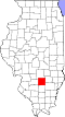
Salem is located in central Marion County. U.S. Route 50 passes through the city center as Main Street, leading east 26 miles (42 km) to Flora and west 23 miles (37 km) to Carlyle. Illinois Route 37 (Broadway) crosses US 50 in the center of town, leading north 7 miles (11 km) to Alma and south 15 miles (24 km) to Dix. Interstate 57 passes through the west side of Salem, with access from Exit 116 (US 50); the Interstate leads northeast 45 miles (72 km) to Effingham and south 21 miles (34 km) to Mount Vernon.
According to the U.S. Census Bureau, Salem has a total area of 7.15 square miles (18.52 km2), of which 6.99 square miles (18.10 km2) are land and 0.16 square miles (0.41 km2), or 2.17%, are water. [3] Town Creek flows through the east side of the city, running to Crooked Creek just south of the city limits. Via Crooked Creek, Salem is part of the Kaskaskia River watershed.
Climate
| Climate data for Salem, Illinois (1991–2020 normals, extremes 1932–present) |
|---|
| Month | Jan | Feb | Mar | Apr | May | Jun | Jul | Aug | Sep | Oct | Nov | Dec | Year |
|---|
| Record high °F (°C) | 71
(22) | 78
(26) | 85
(29) | 91
(33) | 100
(38) | 104
(40) | 105
(41) | 105
(41) | 100
(38) | 94
(34) | 82
(28) | 74
(23) | 105
(41) |
|---|
| Mean maximum °F (°C) | 61.0
(16.1) | 66.6
(19.2) | 75.3
(24.1) | 82.2
(27.9) | 88.0
(31.1) | 93.9
(34.4) | 95.4
(35.2) | 95.1
(35.1) | 91.4
(33.0) | 85.2
(29.6) | 72.9
(22.7) | 62.8
(17.1) | 97.1
(36.2) |
|---|
| Mean daily maximum °F (°C) | 38.4
(3.6) | 43.4
(6.3) | 54.0
(12.2) | 66.2
(19.0) | 75.7
(24.3) | 84.5
(29.2) | 87.8
(31.0) | 86.6
(30.3) | 80.4
(26.9) | 68.7
(20.4) | 54.3
(12.4) | 42.8
(6.0) | 65.2
(18.4) |
|---|
| Daily mean °F (°C) | 29.6
(−1.3) | 33.7
(0.9) | 43.5
(6.4) | 55.0
(12.8) | 65.2
(18.4) | 74.2
(23.4) | 77.6
(25.3) | 75.9
(24.4) | 68.6
(20.3) | 56.9
(13.8) | 44.1
(6.7) | 34.2
(1.2) | 54.9
(12.7) |
|---|
| Mean daily minimum °F (°C) | 20.8
(−6.2) | 24.0
(−4.4) | 33.0
(0.6) | 43.7
(6.5) | 54.6
(12.6) | 63.8
(17.7) | 67.4
(19.7) | 65.2
(18.4) | 56.9
(13.8) | 45.0
(7.2) | 34.0
(1.1) | 25.6
(−3.6) | 44.5
(6.9) |
|---|
| Mean minimum °F (°C) | 1.0
(−17.2) | 7.1
(−13.8) | 16.5
(−8.6) | 29.9
(−1.2) | 40.6
(4.8) | 51.9
(11.1) | 58.8
(14.9) | 56.8
(13.8) | 43.8
(6.6) | 30.8
(−0.7) | 20.1
(−6.6) | 8.2
(−13.2) | −2.0
(−18.9) |
|---|
| Record low °F (°C) | −23
(−31) | −23
(−31) | −8
(−22) | 20
(−7) | 31
(−1) | 38
(3) | 48
(9) | 44
(7) | 33
(1) | 21
(−6) | 2
(−17) | −20
(−29) | −23
(−31) |
|---|
| Average precipitation inches (mm) | 3.07
(78) | 2.56
(65) | 3.73
(95) | 4.69
(119) | 4.99
(127) | 5.08
(129) | 4.07
(103) | 3.80
(97) | 3.54
(90) | 3.44
(87) | 3.99
(101) | 2.93
(74) | 45.89
(1,166) |
|---|
| Average snowfall inches (cm) | 3.9
(9.9) | 2.5
(6.4) | 0.2
(0.51) | 0.0
(0.0) | 0.0
(0.0) | 0.0
(0.0) | 0.0
(0.0) | 0.0
(0.0) | 0.0
(0.0) | 0.1
(0.25) | 0.6
(1.5) | 2.9
(7.4) | 10.2
(26) |
|---|
| Average precipitation days (≥ 0.01 in) | 9.5 | 8.3 | 9.8 | 10.6 | 11.8 | 10.0 | 8.5 | 8.1 | 7.1 | 8.7 | 9.3 | 9.3 | 111.0 |
|---|
| Average snowy days (≥ 0.1 in) | 2.4 | 2.0 | 0.6 | 0.0 | 0.0 | 0.0 | 0.0 | 0.0 | 0.0 | 0.0 | 0.4 | 1.6 | 7.0 |
|---|
| Source: NOAA [9] [10] |
Demographics
Historical population| Census | Pop. | Note | %± |
|---|
| 1870 | 1,182 | | — |
|---|
| 1880 | 1,327 | | 12.3% |
|---|
| 1890 | 1,493 | | 12.5% |
|---|
| 1900 | 1,642 | | 10.0% |
|---|
| 1910 | 2,669 | | 62.5% |
|---|
| 1920 | 3,457 | | 29.5% |
|---|
| 1930 | 4,420 | | 27.9% |
|---|
| 1940 | 7,319 | | 65.6% |
|---|
| 1950 | 6,159 | | −15.8% |
|---|
| 1960 | 6,165 | | 0.1% |
|---|
| 1970 | 6,187 | | 0.4% |
|---|
| 1980 | 7,813 | | 26.3% |
|---|
| 1990 | 7,470 | | −4.4% |
|---|
| 2000 | 7,909 | | 5.9% |
|---|
| 2010 | 7,485 | | −5.4% |
|---|
| 2020 | 7,282 | | −2.7% |
|---|
|
At the 2000 census there were 7,909 people in 3,249 households, including 2,082 families, in the city. The population density was 1,296.5 inhabitants per square mile (500.6/km2). There were 3,473 housing units at an average density of 569.3 per square mile (219.8/km2). The racial makeup of the city was 97.13% White, 0.72% African American, 0.30% Native American, 1.15% Asian, 0.04% Pacific Islander, 0.14% from other races, and 0.52% from two or more races. Hispanic or Latino of any race were 0.72%. [12]
Of the 3,249 households, 28.6% had children under the age of 18 living with them, 48.8% were married couples living together, 11.0% had a female householder with no husband present, and 35.9% were non-families. 32.3% of households were one person and 17.2% were one person aged 65 or older. The average household size was 2.32 and the average family size was 2.91.
The age distribution was 23.5% under the age of 18, 8.7% from 18 to 24, 26.1% from 25 to 44, 22.1% from 45 to 64, and 19.6% 65 or older. The median age was 39 years. For every 100 females, there were 87.6 males. For every 100 females age 18 and over, there were 83.9 males.
The median household income was $34,339 and the median family income was $42,070. Males had a median income of $31,811 versus $21,931 for females. The per capita income for the city was $16,954. About 6.1% of families and 9.2% of the population were below the poverty line, including 13.2% of those under age 18 and 9.2% of those age 65 or over.
This page is based on this
Wikipedia article Text is available under the
CC BY-SA 4.0 license; additional terms may apply.
Images, videos and audio are available under their respective licenses.