Related Research Articles

Clinton County is located in the U.S. state of Illinois. As of the 2010 United States Census, the population was 37,762. Its county seat is Carlyle.
Washington County is a county located in the U.S. state of Illinois. According to the 2010 census, it had a population of 14,716. Its county seat is Nashville. It is located in the southern portion of Illinois known locally as "Little Egypt".

Randolph County is a county located in the U.S. state of Illinois. According to the 2010 census, it had a population of 33,476. Its county seat is Chester.

Monroe County is a county located in the U.S. state of Illinois. According to the 2010 census, it had a population of 32,957. Its county seat and largest city is Waterloo.

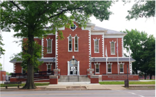
Carlyle is a city in Clinton County, Illinois, United States. The population was 3,281 at the 2010 census. It is the county seat of Clinton County.

Centralia is a city in Clinton, Jefferson, Marion, and Washington counties in the U.S. state of Illinois with the largest portion being within Marion County. The city is the largest in three of the counties; Clinton, Marion, and Washington, but is not a county seat of any of them. The population was 13,032 as of the 2010 census, down from 14,136 in 2000.

Walnut Hill is a village in Marion County, Illinois, United States. The population was 109 at the 2000 census.

The Kaskaskia were one of the indigenous peoples of the Northeastern Woodlands. They were one of about a dozen cognate tribes that made up the Illiniwek Confederation, also called the Illinois Confederation. Their longstanding homeland was in the Great Lakes region. Their first contact with Europeans reportedly occurred near present-day Green Bay, Wisconsin, in 1667 at a Jesuit mission station.

The Kaskaskia River is a tributary of the Mississippi River, approximately 325 miles (523 km) long, in central and southern Illinois in the United States. The second largest river system within Illinois, it drains a rural area of farms, as well as rolling hills along river bottoms of hardwood forests in its lower reaches. The lower reaches of the river have been canalized to allow barge traffic.

Metro East is a region in southern Illinois that comprises the eastern suburbs of St. Louis, Missouri, United States. It encompasses five Southern Illinois counties in the St. Louis Metropolitan Statistical Area. The region's most populated city is Belleville, with 45,000 residents. The Metro East is the second largest urban area in Illinois after the Chicago metropolitan area and, as of the 2000 census, the population of the Metro East statistical area was 599,845 residents, a figure that has risen above 700,000 in 2010. The significant growth in the Metro East is mainly due to people in smaller outlying towns in Illinois moving to the area for better economic/job opportunities.
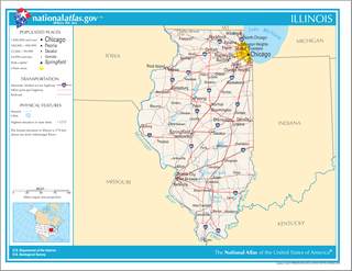
Illinois is in the midwestern United States. Surrounding states are Wisconsin to the north, Iowa and Missouri to the west, Kentucky to the south, and Indiana to the east. Illinois also borders Michigan, but only via a northeastern water boundary in Lake Michigan. Nearly the entire western boundary of Illinois is the Mississippi River, except for a few areas where the river has changed course. Illinois' southeastern and southern boundary is along the Wabash River and the Ohio River, whereas its northern boundary and much of its eastern boundary are straight survey lines. Illinois has a maximum north-south distance of 390 miles and 210 miles east-west. Its total area is 57,918 square miles (150,010 km2).
Goshen Road was an early road that ran from Old Shawneetown, Illinois, on the Ohio River, northwest to the Goshen Settlement, near Glen Carbon, Illinois, near the Mississippi River. In the early 19th century, this was the main east/west road in Illinois.

Carlyle Lake is a 25,000 acres (101.2 km2) reservoir largely located in Clinton County, Illinois, with smaller portions of the lake within Bond and Fayette counties. It is the largest man-made lake in Illinois, and the largest lake wholly contained within the state.

Kaskaskia College is a public community college in Centralia, Illinois. Kaskaskia College's Community College District 501 serves all or part of nine counties, including Bond, Clinton, Fayette, Marion, Washington, Jefferson, St. Clair, Madison and Montgomery. Kaskaskia College is accredited by the Higher Learning Commission.

Ramsey Lake State Recreation Area is a 1,980-acre (800 ha) state park located in Fayette County, Illinois, United States. The nearest town is Ramsey, Illinois, and the park is adjacent to U.S. Highway 51. The park is managed by the Illinois Department of Natural Resources (IDNR).
The Vandalia Baptist Association, a precursor to the Centralia Baptist Association and Kaskaskia Baptist Association, was organized in 1840 and centered in the Vandalia, Illinois, area. It originated from the Saline Fraternity, which was organized in 1834, which in turn was an offspring of the Old South District of the Friends of Humanity.
Shoal Creek is a watercourse in the U.S. state of Illinois. It rises near Harvel, Illinois and, flowing southward through Lake Lou Yaeger, discharges into the Kaskaskia River near Okawville. It drains parts of Montgomery County, Bond County, and Clinton County.
The Kaskaskia were an indigenous North American tribe of the Northeastern Woodlands.
Lake Centralia is a reservoir in Marion County, Illinois. Served by rural roads, it is 8 miles east of the Illinois city of Centralia. The reservoir is 412 acres in size, has a shoreline length of 12.9 miles, and possesses an average water depth of 10 feet. The city, which owns the lake for water-supply purposes, works with the Illinois Department of Natural Resources (IDNR) to stock it with fish. The IDNR reports that lake fishing specializes in stocked bass, including largemouth bass. The lake also offers channel catfish, white and black crappies, and bluegill. The marina is located on the north side of the lake, and there are no restrictions on boat fishing.
Raccoon Lake, also called Raccoon Creek Reservoir, is a reservoir in Marion County, Illinois. Served by Illinois Route 161, it is 2 miles (3 km) northeast of the Illinois city of Centralia. The reservoir is 970 acres in size, has a shoreline length of 16.4 miles, and possesses an average water depth of 3.9 feet.
References
- 1 2 3 Illinois Atlas and Gazetteer. Freeport, Maine: DeLorme. 1991. pp. 77, 78, 83. ISBN 0-89933-213-7.