Hennepin, Illinois

Last updated

Hennepin
Putnam County Courthouse, Hennepin.jpg
Putnam County Illinois Incorporated and Unincorporated areas Hennepin Highlighted.svg
Location of Hennepin in Putnam County, Illinois.
Coordinates: 41°15′10″N89°20′30″W / 41.25278°N 89.34167°W / 41.25278; -89.34167
Country United States
State Illinois
County Putnam
Township Hennepin
Incorporated February 13, 1837
Government
   Mayor Kevin Coleman
   Clerk Diana Brandstatter
   Treasurer Diana Gibson
Area
[1]
  Total5.66 sq mi (14.66 km2)
  Land5.31 sq mi (13.74 km2)
  Water0.35 sq mi (0.92 km2)  6.39%
Elevation
503 ft (153 m)
Population
 (2020)
  Total769
  Density144.90/sq mi (55.95/km2)
Time zone UTC-6 (CST)
  Summer (DST) UTC-5 (CDT)
ZIP codes
61327
FIPS code 17-34098
Website http://www.villageofhennepin.com

Hennepin is a village located on the Illinois River in Putnam County, Illinois, United States. The population was 757 in 2010, an increase of 50 since the 2000 census. It is the county seat and second largest village in Putnam County. [2]

Contents

Hennepin is part of the Ottawa Micropolitan Statistical Area.

History

The Village of Hennepin was named for the explorer, Father Louis Hennepin, O. F. M. [3]

The Putnam County Courthouse, in Hennepin, was built in 1837, and is the oldest county courthouse in Illinois still serving its original purpose. [4] Abraham Lincoln visited the courthouse, including when he campaigned for a Congressional seat in September, 1845. The Putnam County Courthouse is listed on the National Register of Historic Places.

Geography

Climate

Climate data for Hennepin, Illinois (1991–2020)
MonthJanFebMarAprMayJunJulAugSepOctNovDecYear
Mean daily maximum °F (°C)32.3
(0.2)
37.1
(2.8)
50.1
(10.1)
63.5
(17.5)
73.7
(23.2)
81.7
(27.6)
84.5
(29.2)
82.9
(28.3)
77.1
(25.1)
65.2
(18.4)
49.9
(9.9)
36.7
(2.6)
61.2
(16.2)
Daily mean °F (°C)24.6
(−4.1)
28.6
(−1.9)
40.1
(4.5)
52.0
(11.1)
62.5
(16.9)
71.6
(22.0)
74.5
(23.6)
72.7
(22.6)
65.8
(18.8)
54.1
(12.3)
41.1
(5.1)
29.3
(−1.5)
51.4
(10.8)
Mean daily minimum °F (°C)16.8
(−8.4)
20.1
(−6.6)
30.1
(−1.1)
40.5
(4.7)
51.3
(10.7)
61.4
(16.3)
64.5
(18.1)
62.4
(16.9)
54.5
(12.5)
43.0
(6.1)
32.3
(0.2)
21.8
(−5.7)
41.6
(5.3)
Average precipitation inches (mm)1.95
(50)
1.80
(46)
2.46
(62)
3.85
(98)
4.76
(121)
4.55
(116)
3.89
(99)
3.77
(96)
3.45
(88)
3.31
(84)
2.60
(66)
2.19
(56)
38.58
(982)
Source: NOAA [5]

Demographics

Historical population
CensusPop.Note
1880 623
1890 574−7.9%
1900 523−8.9%
1910 451−13.8%
1920 377−16.4%
1930 312−17.2%
1940 39626.9%
1950 312−21.2%
1960 39125.3%
1970 53536.8%
1980 71633.8%
1990 669−6.6%
2000 7075.7%
2010 7577.1%
2020 7691.6%
U.S. Decennial Census [6]

As of the census [7] of 2000, there were 707 people, 304 households, and 206 families residing in the village. The population density was 135.4 inhabitants per square mile (52.3/km2). There were 334 housing units at an average density of 64.0 per square mile (24.7/km2). The racial makeup of the village was 97.17% White, 1.13% African American, 0.28% Native American, 0.71% Asian, 0.57% from other races, and 0.14% from two or more races. Hispanic or Latino of any race were 3.82% of the population.

There were 304 households, out of which 26.6% had children under the age of 18 living with them, 59.2% were married couples living together, 5.6% had a female householder with no husband present, and 32.2% were non-families. 30.3% of all households were made up of individuals, and 16.1% had someone living alone who was 65 years of age or older. The average household size was 2.32 and the average family size was 2.87.

In the village, the population was spread out, with 20.8% under the age of 18, 9.2% from 18 to 24, 24.6% from 25 to 44, 27.0% from 45 to 64, and 18.4% who were 65 years of age or older. The median age was 42 years. For every 100 females, there were 96.4 males. For every 100 females age 18 and over, there were 92.4 males.

The median income for a household in the village was $46,827, and the median income for a family was $56,111. Males had a median income of $48,500 versus $19,231 for females. The per capita income for the village was $23,981. About 2.6% of families and 2.9% of the population were below the poverty line, including 5.6% of those under age 18 and 2.9% of those age 65 or over.

Industry

Hennepin's location on the Illinois River, along with its proximity to a Class I railroad (Norfolk Southern Railway), and multiple inter and intrastate highway routes (Interstate 80, Interstate 39, Illinois Route 180, Illinois Route 89, Illinois Route 71, Illinois Route 26, and Illinois Route 6) has, historically, made it a transportation hub attracting a variety of both small businesses and large industries.

J&L Steel, a cold roll steel mill built by Jones and Laughlin Steel Company on Hennepin's northern boundary, began operations in 1967 and employed 600 workers at height of production. The mill was later acquired by Ling-Temco-Vought, at which time it became known as LTV Steel. Ling-Temco-Vought's bankruptcy led to acquisition of the mill by International Steel Group (ISG). As a result of additional acquisitions followed by a merger, Putnam County's largest employer was absorbed by ArcelorMittal. Long and arduous union lobbying and protests ultimately proved futile and ArcelorMittal ceased production at the mill in March, 2009. The mill's equipment was dismantled, sold, or shipped and on June 22, 2017, the vast plant was imploded. As of 2020, the 800 acres once occupied by the steel mill remain mostly vacant, though infrastructure has been retained in anticipation that another industry might one day purchase and redevelop the property.

Hennepin Power Station, a coal-fired power plant near Donnelley Wildlife Area on the western edge of town, was retired November 1, 2019.

There are also Cargill, ADM, and CGB elevators throughout the area.

Marquis Energy opened a 100 million gallon/year ICM/Fagen ethanol plant just north of town in April 2008.

Landmarks

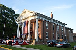
Edward Pulsifer House, museum and headquarters of the Putnam County Historical Society

Putnam County Historical Society's Agriculture Museum

Putnam County Courthouse (Illinois)

The Dixon Waterfowl Refuge, a privately maintained wetland, is located two miles south of Hennepin.

Notable people

Related Research Articles

<span class="mw-page-title-main">Putnam County, Illinois</span> County in Illinois, United States

Putnam County is the least extensive county in the U.S. state of Illinois. According to the 2020 census, it had a population of 5,637. The county seat is Hennepin. The county was formed in 1825 out of Fulton County and named after Israel Putnam, who was a general in the American Revolution. Putnam County is part of the Ottawa, IL Micropolitan Statistical Area.

<span class="mw-page-title-main">Putnam County, Missouri</span> County in Missouri, United States

Putnam County is in north central Missouri. At the 2020 census, the population was 4,681. Its county seat is Unionville. The county was organized February 28, 1845, and named for Israel Putnam, a hero in the French and Indian War and a general in the American Revolutionary War.

<span class="mw-page-title-main">Bond County, Illinois</span> County in Illinois, United States

Bond County is a county located in the U.S. state of Illinois. As of the 2020 census, the population was 16,725. Its county seat is Greenville.

<span class="mw-page-title-main">Liverpool, Illinois</span> Village in Illinois, United States

Liverpool is a village in Fulton County, Illinois, United States. The population was 94 at the 2010 census.

<span class="mw-page-title-main">London Mills, Illinois</span> Village in Illinois, United States

London Mills is a village in Fulton and Knox counties in the U.S. state of Illinois. The population was 350 at the 2020 census.

<span class="mw-page-title-main">Elizabethtown, Illinois</span> Village in Illinois, United States

Elizabethtown is a village in and the county seat of Hardin County, Illinois, United States, along the Ohio River. The population was 299 at the 2010 census, down from 348 at the 2000 census. It is the least-populous county seat in the state.

<span class="mw-page-title-main">Watseka, Illinois</span> City in Illinois, United States

Watseka is a city in and the county seat of Iroquois County, Illinois, United States. It is located approximately 15 miles (24 km) west of the Illinois-Indiana state line on U.S. Route 24.

<span class="mw-page-title-main">Vienna, Illinois</span> City in Illinois, United States

Vienna is a city in and the county seat of Johnson County, Illinois, United States, and it is the site of two well-known state penitentiaries. The population of Vienna was 1,434 at the 2010 census.

<span class="mw-page-title-main">St. Augustine, Illinois</span> Village in Illinois, United States

St. Augustine or Saint Augustine is a village in Knox County, Illinois, United States. The population was 120 at the 2010 census, down from 152 at the 2000 census. It is part of the Galesburg Micropolitan Statistical Area.

<span class="mw-page-title-main">Reynolds, Illinois</span> Village in Illinois, United States

Reynolds is a village mainly in Rock Island County in the U.S. state of Illinois. The population was 498 at the 2020 census. A small portion on the south side is in Mercer County. The village was founded in 1876.

<span class="mw-page-title-main">Magnolia, Illinois</span> Place in Illinois, United States

Magnolia is a village in Putnam County, Illinois, United States. The population was 260 at the 2010 census. It is part of the Ottawa Micropolitan Statistical Area.

<span class="mw-page-title-main">Milan, Illinois</span> Village in Illinois, United States

Milan is a village in Rock Island County, Illinois, United States. The population was 5,097 at the time of the 2020 census; down from 5,099 at the 2010 census.

<span class="mw-page-title-main">Mill Creek, Illinois</span> Village in Illinois, United States

Mill Creek is a village in Union County, Illinois, United States. The population was 59 at the 2020 census.

<span class="mw-page-title-main">East Chicago, Indiana</span> City in Indiana, United States

East Chicago is a city in Lake County, Indiana, United States. The population was 26,370 at the 2020 census. Centered around heavy industry, the city is home to the Indiana Harbor and Ship Canal, an artificial freshwater harbor characterized by industrial and manufacturing activity.

<span class="mw-page-title-main">Steelton, Pennsylvania</span> Borough in Pennsylvania, United States

Steelton is a borough in Dauphin County, Pennsylvania, United States, 4 miles (6 km) southeast of Harrisburg. The population was 6,263 at the 2020 census. The borough is part of the Harrisburg–Carlisle Metropolitan Statistical Area.

<span class="mw-page-title-main">Vinton, Texas</span> Village in Texas, United States

Vinton is a village in El Paso County, Texas, United States. The population was 1,971 at the 2010 census. It is part of the El Paso Metropolitan Statistical Area.

<span class="mw-page-title-main">Rockford, Minnesota</span> City in Minnesota, United States

Rockford is a city in Wright and Hennepin counties in the U.S. state of Minnesota. The population was 4,316 at the 2010 census. While Rockford is mainly located within Wright County, a small part of the city extends into Hennepin County. It is part of the Minneapolis–Saint Paul metropolitan statistical area. Minnesota State Highway 55 serves as a main route in the city.

<span class="mw-page-title-main">Weirton, West Virginia</span> City in West Virginia, United States

Weirton is a city in Hancock and Brooke counties in the U.S. state of West Virginia. Located along the Ohio River in the state's Northern Panhandle, the city's population was 19,163 as of the 2020 census, making it the seventh most populous city in the state.

<span class="mw-page-title-main">Mulberry Grove Township, Bond County, Illinois</span> Township in Illinois, United States

Mulberry Grove Township is one of nine townships in Bond County, Illinois, USA. As of the 2020 census, its population was 1,133 and it contained 569 housing units.

<span class="mw-page-title-main">Portage, Indiana</span> City in Indiana, United States

Portage is a city in Portage Township, Porter County, in the U.S. state of Indiana, on the border with Lake County. The population was 37,926 as of the 2020 census. It is the largest city in Porter County, and third largest in Northwest Indiana.

References

  1. "2020 U.S. Gazetteer Files". United States Census Bureau. Retrieved March 15, 2022.
  2. "Find a County". National Association of Counties. Archived from the original on May 31, 2011. Retrieved June 7, 2011.
  3. Gannett, Henry (1905). The Origin of Certain Place Names in the United States. Govt. Print. Off. pp.  155.
  4. "Putnam County, Illinois, USA". illinois.outfitters.com.
  5. "NOAA NCEI U.S. Climate Normals Quick Access". NOAA. Retrieved April 17, 2024.
  6. "Census of Population and Housing". Census.gov. Retrieved June 4, 2015.
  7. "U.S. Census website". United States Census Bureau . Retrieved January 31, 2008.
  8. 'Wisconsin Blue Book 1907,' Biographical Sketch of Albert W. Durley. pg. 1147
  9. "USGS: John Wesley Powell: Soldier, Explorer, Scientist". Archived from the original on July 16, 2007.