Schuyler County, Illinois

Last updated

Schuyler County
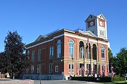
Schuyler County Courthouse, Rushville.jpg
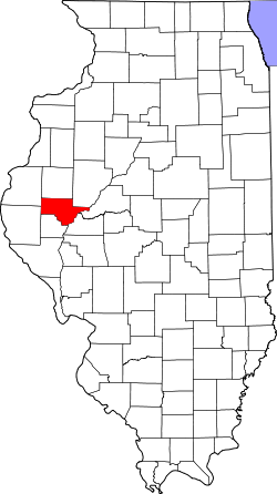
Map of Illinois highlighting Schuyler County.svg
Location within the U.S. state of Illinois
Illinois in United States.svg
Illinois's location within the U.S.
Coordinates: 40°10′N90°37′W / 40.16°N 90.61°W / 40.16; -90.61
CountryFlag of the United States.svg United States
StateFlag of Illinois.svg  Illinois
Founded1825
Named for Philip Schuyler
Seat Rushville
Largest cityRushville
Area
  Total441 sq mi (1,140 km2)
  Land437 sq mi (1,130 km2)
  Water4.1 sq mi (11 km2)  0.9%
Population
 (2020)
  Total6,902
  Density16/sq mi (6.0/km2)
Time zone UTC−6 (Central)
  Summer (DST) UTC−5 (CDT)
Congressional district 15th
Website www.schuylercountyillinois.com

Schuyler County is a county in the U.S. state of Illinois. According to the 2020 census, it had a population of 6,902. [1] Its county seat is Rushville. [2]

Contents

History

Schuyler County was formed in 1825 out of Pike and Fulton counties. It is named for Philip Schuyler, member of the Continental Congress and Senator from New York. In 1826, the county seat was moved from Beardstown (now in Cass County) to Rushville. [3]

Geography

According to the US Census Bureau, the county has a total area of 441 square miles (1,140 km2), of which 437 square miles (1,130 km2) is land and 4.1 square miles (11 km2) (0.9%) is water. [5]

Climate and weather

Rushville, Illinois
Climate chart (explanation)
J
F
M
A
M
J
J
A
S
O
N
D
 
 
1.6
 
 
32
15
 
 
1.9
 
 
38
20
 
 
3.1
 
 
50
30
 
 
3.9
 
 
63
41
 
 
5.1
 
 
73
51
 
 
3.9
 
 
82
61
 
 
3.9
 
 
87
65
 
 
3.5
 
 
84
63
 
 
3.6
 
 
78
54
 
 
3.3
 
 
66
43
 
 
3.2
 
 
50
31
 
 
2.4
 
 
37
20
Average max. and min. temperatures in °F
Precipitation totals in inches
Source: The Weather Channel [6]
Metric conversion
J
F
M
A
M
J
J
A
S
O
N
D
 
 
39
 
 
0
−9
 
 
48
 
 
3
−7
 
 
77
 
 
10
−1
 
 
99
 
 
17
5
 
 
131
 
 
23
11
 
 
100
 
 
28
16
 
 
98
 
 
31
18
 
 
90
 
 
29
17
 
 
92
 
 
26
12
 
 
83
 
 
19
6
 
 
80
 
 
10
−1
 
 
62
 
 
3
−7
Average max. and min. temperatures in °C
Precipitation totals in mm

In recent years, average temperatures in the county seat of Rushville have ranged from a low of 15 °F (−9 °C) in January to a high of 87 °F (31 °C) in July, although a record low of −26 °F (−32 °C) was recorded in February 1905 and a record high of 113 °F (45 °C) was recorded in July 1936. Average monthly precipitation ranged from 1.55 inches (39 mm) in January to 5.14 inches (131 mm) in May. [6]

Major highways

Adjacent counties

Demographics

Historical population
CensusPop.Note
1840 6,972
1850 10,57351.6%
1860 14,68438.9%
1870 17,41918.6%
1880 16,249−6.7%
1890 16,013−1.5%
1900 16,1290.7%
1910 14,852−7.9%
1920 13,285−10.6%
1930 11,676−12.1%
1940 11,430−2.1%
1950 9,613−15.9%
1960 8,746−9.0%
1970 8,135−7.0%
1980 8,3652.8%
1990 7,498−10.4%
2000 7,189−4.1%
2010 7,5444.9%
2020 6,902−8.5%
2023 (est.)6,733 [7] −2.4%
US Decennial Census [8]
1790-1960 [9] 1900-1990 [10]
1990-2000 [11] 2010 [12]

As of the 2010 United States Census, there were 7,544 people, 3,040 households, and 2,014 families residing in the county. [13] The population density was 17.3 inhabitants per square mile (6.7/km2). There were 3,459 housing units at an average density of 7.9 per square mile (3.1/km2). [5] The racial makeup of the county was 95.5% white, 3.2% black or African American, 0.2% American Indian, 0.1% Asian, 0.5% from other races, and 0.5% from two or more races. Those of Hispanic or Latino origin made up 1.2% of the population. [13] In terms of ancestry, 26.8% were American, 20.2% were German, 13.1% were English, and 12.0% were Irish. [14]

Of the 3,040 households, 28.2% had children under the age of 18 living with them, 53.5% were married couples living together, 7.6% had a female householder with no husband present, 33.8% were non-families, and 28.6% of all households were made up of individuals. The average household size was 2.33 and the average family size was 2.83. The median age was 43.6 years. [13]

The median income for a household in the county was $43,686 and the median income for a family was $51,654. Males had a median income of $40,998 versus $28,810 for females. The per capita income for the county was $20,649. About 8.6% of families and 14.0% of the population were below the poverty line, including 16.8% of those under age 18 and 14.1% of those age 65 or over. [15]

Government and politics

In 1853, Schyler County adopted the township form of county government. [3] Since November 22, 2013, Schuyler County is located in Regional Office of Education #26 alongside Hancock, Fulton, and McDonough counties. [16]

The county is located in Illinois's 15th Congressional District and is currently represented by Republican Mary Miller. In the Illinois General Assembly, the county is split between multiple legislative districts. The northern portion of the county is located in the 47th legislative district and the 94th house district represented by Senator Neil Anderson and Representative Norine Hammond respectively. The southern portion of the county is located in the 50th legislative district and the 99th house district represented by Senator Jil Tracy and Representative Randy Frese respectively. [17]

In presidential elections, Schuyler County usually favors Republican candidates, having voted for Democratic presidential candidates in only four elections during the period of 1944–2020. Since 1944, the Democratic candidate has won a majority of the vote in Schuyler County only once (in 1964).

United States presidential election results for Schuyler County, Illinois [18]
Year Republican Democratic Third party
No.%No.%No.%
2020 2,77370.78%1,06827.26%771.97%
2016 2,52465.83%1,07528.04%2356.13%
2012 2,06953.02%1,72744.26%1062.72%
2008 1,83347.75%1,90049.49%1062.76%
2004 2,40359.61%1,59439.54%340.84%
2000 2,07755.06%1,58742.07%1082.86%
1996 1,59742.60%1,63643.64%51613.76%
1992 1,51237.85%1,65041.30%83320.85%
1988 2,17853.57%1,86645.89%220.54%
1984 2,51561.93%1,53337.75%130.32%
1980 2,79962.76%1,44532.40%2164.84%
1976 2,63556.44%2,01443.14%200.43%
1972 2,99466.03%1,53433.83%60.13%
1968 2,76060.00%1,47532.07%3657.93%
1964 2,41749.12%2,50450.88%00.00%
1960 3,04759.00%2,11540.96%20.04%
1956 3,06858.22%2,18941.54%130.25%
1952 3,29561.30%2,07638.62%40.07%
1948 2,51949.65%2,46448.56%911.79%
1944 2,80151.82%2,55547.27%490.91%
1940 3,31848.77%3,40450.04%811.19%
1936 3,02943.54%3,88555.84%430.62%
1932 2,07534.99%3,78263.78%731.23%
1928 3,01154.00%2,54245.59%230.41%
1924 2,72946.21%2,86048.43%3175.37%
1920 2,80053.86%2,25843.43%1412.71%
1916 2,59541.57%3,39254.34%2554.09%
1912 69420.25%1,71450.00%1,02029.75%
1908 1,62243.31%1,87650.09%2476.60%
1904 1,63645.28%1,68246.55%2958.16%
1900 1,79144.22%2,16753.51%922.27%
1896 1,84843.37%2,33454.78%791.85%
1892 1,56341.20%1,88049.55%3519.25%

Communities

City

Villages

Unincorporated communities

Townships

See also

Related Research Articles

<span class="mw-page-title-main">Warren County, Illinois</span> County in Illinois, United States

Warren County is a county in the U.S. state of Illinois. According to the 2020 census, it had a population of 16,835. Its county seat is Monmouth.

<span class="mw-page-title-main">McDonough County, Illinois</span> County in Illinois, United States

McDonough County is a county in the U.S. state of Illinois. According to the 2020 census, it had a population of 27,238. Its county seat is Macomb, which is also the home of Western Illinois University.

<span class="mw-page-title-main">Mason County, Illinois</span> County in Illinois, United States

Mason County is a county in the U.S. state of Illinois. According to the 2020 census, it had a population of 13,086. Its county seat is Havana. The county is named in honor of George Mason, a member of the Virginia legislature who campaigned for the adoption of the United States Bill of Rights.

<span class="mw-page-title-main">Hancock County, Illinois</span> County in Illinois, United States

Hancock County is a county in the U.S. state of Illinois. According to the 2020 census, it has a population of 17,620. Its county seat is Carthage, and its largest city is Hamilton. The county is composed of rural towns with many farmers.

<span class="mw-page-title-main">Fulton County, Illinois</span> County in Illinois, United States

Fulton County is a county in the U.S. state of Illinois. According to the 2020 census, it had a population of 33,609. Its county seat is Lewistown, and the largest city is Canton. Fulton County comprises the Canton, IL Micropolitan Statistical Area, which is part of the Peoria-Canton, IL Combined Statistical Area.

<span class="mw-page-title-main">Cass County, Illinois</span> County in Illinois, United States

Cass County is a county located in the U.S. state of Illinois. As of the 2020 United States Census, the population was 13,042. Its county seat is Virginia. It is the home of the Jim Edgar Panther Creek State Fish and Wildlife Area.

<span class="mw-page-title-main">Brown County, Illinois</span> County in Illinois, United States

Brown County is a county located in the U.S. state of Illinois. As of the 2020 census, the population was 6,244. Its county seat is Mount Sterling.

<span class="mw-page-title-main">Fulton, Arkansas</span> Town in Arkansas, United States

Fulton is a town in Hempstead County, Arkansas, United States. The population was 201 at the 2010 census. It is part of the Hope Micropolitan Statistical Area. The community is named after steamboat inventor Robert Fulton.

<span class="mw-page-title-main">Astoria, Illinois</span> Town in Illinois, United States

Astoria is an incorporated town in Fulton County, Illinois, United States. The population was 929 at the 2020 census.

<span class="mw-page-title-main">London Mills, Illinois</span> Village in Illinois, United States

London Mills is a village in Fulton and Knox counties in the U.S. state of Illinois. The population was 350 at the 2020 census.

<span class="mw-page-title-main">Blandinsville, Illinois</span> Village in Illinois, United States

Blandinsville is a village in McDonough County, Illinois, United States. The population was 569 at the 2020 census, down from 651 in 2010.

<span class="mw-page-title-main">Industry, Illinois</span> Village in Illinois, United States

Industry is a village in McDonough County, Illinois, United States. As of the 2020 census, the village population was 399, down from 478 in 2010.

<span class="mw-page-title-main">Tennessee, Illinois</span> Village in Illinois, United States

Tennessee is a village in McDonough County, Illinois, United States. The population was 101 at the 2020 census.

<span class="mw-page-title-main">Rushville, Illinois</span> City in Illinois, United States

Rushville is a city in Schuyler County, Illinois, United States. The population was 3,005 at the 2020 census. It is the county seat of Schuyler County. It was first settled by Euro-Americans in 1823.

<span class="mw-page-title-main">West Rushville, Ohio</span> Village in Ohio, United States

West Rushville is a village in Fairfield County, Ohio, United States. The population was 166 at the 2020 census.

<span class="mw-page-title-main">Fairview Township, Fulton County, Illinois</span> Township in Illinois, United States

Fairview Township is one of 26 townships in Fulton County, in the U.S. state of Illinois. As of the 2020 census, its population was 596 and it contained 285 housing units.

<span class="mw-page-title-main">Farmers Township, Fulton County, Illinois</span> Township in Illinois, United States

Farmers Township is one of twenty-six townships in Fulton County, Illinois, USA. As of the 2020 census, its population was 370 and it contained 180 housing units.

<span class="mw-page-title-main">Harris Township, Fulton County, Illinois</span> Township in Illinois, United States

Harris Township is one of twenty-six townships in Fulton County, Illinois, USA. As of the 2020 census, its population was 312 and it contained 155 housing units.

<span class="mw-page-title-main">Putman Township, Fulton County, Illinois</span> Township in Illinois, United States

Putman Township is one of twenty-six townships in Fulton County, Illinois, USA. As of the 2020 census, its population was 1,967 and it contained 935 housing units.

<span class="mw-page-title-main">Vermont Township, Fulton County, Illinois</span> Township in Illinois, United States

Vermont Township is one of twenty-six townships in Fulton County, Illinois, USA. As of the 2020 census, its population was 848 and it contained 411 housing units.

References

  1. "Schuyler County, Illinois". United States Census Bureau . Retrieved June 10, 2023.
  2. "Find a County". National Association of Counties. Retrieved June 7, 2011.
  3. 1 2 White, Jesse (ed.). "Schuyler County". Illinois Regional Archives Depository System. Illinois Secretary of State. Archived from the original on May 15, 2021. Retrieved December 27, 2023.
  4. White, Jesse. Origin and Evolution of Illinois Counties. State of Illinois, March 2010.
  5. 1 2 "Population, Housing Units, Area, and Density: 2010 - County". US Census Bureau. Archived from the original on February 12, 2020. Retrieved July 12, 2015.
  6. 1 2 "Monthly Averages for Rushville IL". The Weather Channel. Retrieved January 27, 2011.
  7. "Annual Estimates of the Resident Population for Counties: April 1, 2020 to July 1, 2023". United States Census Bureau. Retrieved April 2, 2024.
  8. "US Decennial Census". US Census Bureau. Retrieved July 8, 2014.
  9. "Historical Census Browser". University of Virginia Library. Retrieved July 8, 2014.
  10. "Population of Counties by Decennial Census: 1900 to 1990". US Census Bureau. Retrieved July 8, 2014.
  11. "Census 2000 PHC-T-4. Ranking Tables for Counties: 1990 and 2000" (PDF). US Census Bureau. Retrieved July 8, 2014.
  12. "State & County QuickFacts". US Census Bureau. Archived from the original on June 7, 2011. Retrieved July 8, 2014.
  13. 1 2 3 "Profile of General Population and Housing Characteristics: 2010 Demographic Profile Data". US Census Bureau. Archived from the original on February 13, 2020. Retrieved July 12, 2015.
  14. "Selected Social Characteristics in the United States – 2006-2010 American Community Survey 5-Year Estimates". US Census Bureau. Archived from the original on February 13, 2020. Retrieved July 12, 2015.
  15. "Selected Economic Characteristics – 2006-2010 American Community Survey 5-Year Estimates". US Census Bureau. Archived from the original on February 13, 2020. Retrieved July 12, 2015.
  16. Chico, Gery J. (November 23, 2013). "Order of the State Board of Education Pursuant to 105 ILCS 5/3A-4 (a)" (PDF). Illinois State Board of Education. Archived from the original (PDF) on January 6, 2018. Retrieved April 24, 2022.
  17. "Maps of Districts of the Illinois House of Representatives (2023-2033)". Illinois State Board of Elections. July 16, 2022. Retrieved November 14, 2022.
  18. Leip, David. "Atlas of US Presidential Elections". uselectionatlas.org. Retrieved November 12, 2018.

40°10′N90°37′W / 40.16°N 90.61°W / 40.16; -90.61